

Mount Holyoke
Encyclopedia
Mount Holyoke, a traprock mountain, elevation 935 feet (285 m), is the western-most peak of the Holyoke Range
and part of the 100-mile (160 km) Metacomet Ridge
. The mountain is located in the Connecticut River Valley of western Massachusetts
, and is the namesake of nearby Mount Holyoke College
. The mountain is located in the towns of Hadley
and South Hadley, Massachusetts
. It is known for its historic summit house, auto road, scenic vistas, and biodiversity
. The mountain is crossed by the 110 miles (177 km) Metacomet-Monadnock Trail
and numerous shorter trails. Mount Holyoke is the home of J.A. Skinner State Park which is accessible from Route 47
in Hadley, Massachusetts
.
, an early resident of Springfield, Massachusetts
who first explored the mountainous region that came to bear his name. The city of Holyoke, Massachusetts
and Mount Holyoke Female Seminary (now Mount Holyoke College
) were both named after the nearby Mount Holyoke and not directly after Elizur Holyoke.
 In 1821, an 18 by guest cabin was built on Mount Holyoke by a local committee—one of the first New England summit houses. The property changed hands several times between 1821 and 1851 when it was bought and rebuilt as a two-story, eight-room hotel. Local entrepreneurs John and Frances French were the primary owners; between 1851 and 1900, the hotel and property were subject to a number of upgrades and related construction projects including a covered tramway to the summit of the mountain (first drawn by horse, then mechanized), a railroad from the base of the mountain to a steamboat
dock on the Connecticut River, and the construction of a number of outbuildings and trails. With passenger steamship to the connecting summit railway established, the Mount Holyoke "Prospect House" became a popular tourist destination. The steamship would pick up guests at the Smiths Ferry railroad station across the Connecticut River in what was then Northampton
, ferry them to a tramway leading to the Half Way House. From there guests could take a steep (600 feet long, rising 365 feet) covered inclined tram to the summit (shown in drawing at right). The track for this tram was first laid in 1867 and the system electrified in 1926. Competing establishments were soon built on Mount Tom
and Mount Nonotuck
across the Connecticut River, and on Sugarloaf Mountain
and Mount Toby
to the north. The Prospect House property passed hands again in the early 1900s, to chain hotel
ier Joseph Allen Skinner, who eventually donated the hotel and property to the Commonwealth of Massachusetts for a state park in 1939 on the condition that the park be named after him (now the J.A. Skinner State Park).
The summit house's 1894 annex had suffered from storm damage during the Great Hurricane of 1938 and had been demolished; in 1942 the enclosed tramway to the summit house broke down. A heavy snow storm in 1948 collapsed sections of the roof. Despite proposals to repair the tram it never ran again. The tram was finally demolished in 1965. State funds for maintenance of the summit house during the 1950s and 1960s were never adequate and by the mid-1970s there were proposals to condemn and demolish the summit house. This led to a public outcry and in the mid-1980s the summit house, consisting of the original 1851 structure and the 1861 addition, was restored by the state and through the efforts of local volunteers.
, also called trap rock
, a volcanic rock. The mountain formed near the end of the Triassic Period with the rifting apart of the North America
n continent from Africa
and Eurasia
. Lava
welled up from the rift and solidified into sheets of strata hundreds of feet thick. Subsequent faulting and earthquake
activity tilted the strata, creating the dramatic cliffs and ridges of Mount Holyoke. Hot, dry upper slopes, cool, moist ravines, and mineral-rich ledges of basalt talus
produce a combination of microclimate
ecosystems on the mountain that support plant and animal species uncommon in greater Massachusetts. (See Metacomet Ridge
for more information on the geology and ecosystem of Mount Holyoke).
through Columbus Day
. A number of hiking trails also cross the mountain, most notably the 110 mile (180k) Metacomet-Monadnock Trail
and the 47 miles (75.6 km) Robert Frost Trail
.
Every year in early fall, since 1838, students from nearby Mount Holyoke College
participate in Mountain Day
. On that day, at the sound of ringing bells from Abbey Chapel on a random Autumn morning, all classes are cancelled and students hike to the summit of Mount Holyoke.
The area around the summit house has many picnic tables. Also, there are trailheads and memorials. One notable memorial is that to the men aboard a transport plane that crashed into the flank of the mountain. On May 27, 1944, a B-24, flying a night training mission out of Westover Air Force Base in Chicopee, Massachusetts
, crashed into the side of the range, killing all ten crewmen. A memorial plaque on the summit of Mount Holyoke eulogizes the disaster. The crash site itself is a few hundred feet away.
The views from the top of the mountain are some of the best in Massachusetts. They have inspired artists and poets. The nearby Connecticut River Oxbow
(now a lake), immortalized by the famous landscape painter Thomas Cole
just four years before natural flooding and erosion separated it from the Connecticut River, was composed from sketches the artist made from the summit of Mount Holyoke in 1836. To the south are the cities of Holyoke, Springfield, and Hartford. To the north are the University of Massachusetts in Amherst and mountains in Sunderland. To the east is the Holyoke Range and the town of South Hadley. To the west are the foothills of the Berkshires, the Connecticut River, and Northampton.
is a sister park occupying the east side of the Holyoke Range. Its visitor center is located at "the Notch", where Route 116
crosses the range in Amherst
.
In 2000, Mount Holyoke was included in a study by the National Park Service
for the designation of a new National Scenic Trail
now tentatively called the New England National Scenic Trail
, which would include the Metacomet-Monadnock Trail
in Massachusetts and the Mattabesett Trail
and Metacomet Trail
trails in Connecticut.
Holyoke Range
The Holyoke Range or Mount Holyoke Range is a traprock mountain range located in the Connecticut River Valley of Massachusetts. It is a sub-range of the narrow, linear Metacomet Ridge that extends from Long Island Sound near New Haven, Connecticut north through the Connecticut River Valley of...
and part of the 100-mile (160 km) Metacomet Ridge
Metacomet Ridge
The Metacomet Ridge, Metacomet Ridge Mountains, or Metacomet Range of southern New England, United States, is a narrow and steep fault-block mountain ridge known for its extensive cliff faces, scenic vistas, microclimate ecosystems, and communities of plants considered rare or endangered...
. The mountain is located in the Connecticut River Valley of western Massachusetts
Massachusetts
The Commonwealth of Massachusetts is a state in the New England region of the northeastern United States of America. It is bordered by Rhode Island and Connecticut to the south, New York to the west, and Vermont and New Hampshire to the north; at its east lies the Atlantic Ocean. As of the 2010...
, and is the namesake of nearby Mount Holyoke College
Mount Holyoke College
Mount Holyoke College is a liberal arts college for women in South Hadley, Massachusetts. It was the first member of the Seven Sisters colleges, and served as a model for some of the others...
. The mountain is located in the towns of Hadley
Hadley, Massachusetts
Hadley is a town in Hampshire County, Massachusetts. The population was 4,793 at the 2000 census. It is part of the Springfield, Massachusetts Metropolitan Statistical Area. The area around Hampshire Mall and Mountain Farms Mall along Route 9 is a major shopping destination for the surrounding...
and South Hadley, Massachusetts
South Hadley, Massachusetts
South Hadley is a town in Hampshire County, Massachusetts, United States. The population was 17,514 at the 2010 census. It is part of the Springfield, Massachusetts Metropolitan Statistical Area....
. It is known for its historic summit house, auto road, scenic vistas, and biodiversity
Biodiversity
Biodiversity is the degree of variation of life forms within a given ecosystem, biome, or an entire planet. Biodiversity is a measure of the health of ecosystems. Biodiversity is in part a function of climate. In terrestrial habitats, tropical regions are typically rich whereas polar regions...
. The mountain is crossed by the 110 miles (177 km) Metacomet-Monadnock Trail
Metacomet-Monadnock Trail
The Metacomet-Monadnock Trail is a hiking trail that traverses the Metacomet Ridge of the Pioneer Valley region of Massachusetts and the central uplands of Massachusetts and southern New Hampshire...
and numerous shorter trails. Mount Holyoke is the home of J.A. Skinner State Park which is accessible from Route 47
Massachusetts Route 47
Route 47 is a north–south state highway in the Pioneer Valley region of the U.S. state of Massachusetts.-Route description:Route 47 begins at Route 116 in South Hadley near the northwest corner of the Mount Holyoke College campus. It heads northwestward towards the southwest corner of...
in Hadley, Massachusetts
Hadley, Massachusetts
Hadley is a town in Hampshire County, Massachusetts. The population was 4,793 at the 2000 census. It is part of the Springfield, Massachusetts Metropolitan Statistical Area. The area around Hampshire Mall and Mountain Farms Mall along Route 9 is a major shopping destination for the surrounding...
.
Origin of name
The mountain was named after Elizur HolyokeElizur Holyoke
Captain Elizur Holyoke of Springfield, Massachusetts was the namesake of the mountain, Mount Holyoke, and , of the city of Holyoke, Massachusetts.-Background:...
, an early resident of Springfield, Massachusetts
Springfield, Massachusetts
Springfield is the most populous city in Western New England, and the seat of Hampden County, Massachusetts, United States. Springfield sits on the eastern bank of the Connecticut River near its confluence with three rivers; the western Westfield River, the eastern Chicopee River, and the eastern...
who first explored the mountainous region that came to bear his name. The city of Holyoke, Massachusetts
Holyoke, Massachusetts
Holyoke is a city in Hampden County, Massachusetts, United States, between the western bank of the Connecticut River and the Mount Tom Range of mountains. As of the 2010 Census, the city had a population of 39,880...
and Mount Holyoke Female Seminary (now Mount Holyoke College
Mount Holyoke College
Mount Holyoke College is a liberal arts college for women in South Hadley, Massachusetts. It was the first member of the Seven Sisters colleges, and served as a model for some of the others...
) were both named after the nearby Mount Holyoke and not directly after Elizur Holyoke.
The Mount Holyoke Summit House
Steamboat
A steamboat or steamship, sometimes called a steamer, is a ship in which the primary method of propulsion is steam power, typically driving propellers or paddlewheels...
dock on the Connecticut River, and the construction of a number of outbuildings and trails. With passenger steamship to the connecting summit railway established, the Mount Holyoke "Prospect House" became a popular tourist destination. The steamship would pick up guests at the Smiths Ferry railroad station across the Connecticut River in what was then Northampton
Northampton, Massachusetts
The city of Northampton is the county seat of Hampshire County, Massachusetts, United States. As of the 2010 census, the population of Northampton's central neighborhoods, was 28,549...
, ferry them to a tramway leading to the Half Way House. From there guests could take a steep (600 feet long, rising 365 feet) covered inclined tram to the summit (shown in drawing at right). The track for this tram was first laid in 1867 and the system electrified in 1926. Competing establishments were soon built on Mount Tom
Mount Tom (Massachusetts)
Mount Tom, , is a steep, rugged traprock mountain peak on the west bank of the Connecticut River 4.5 miles northwest of downtown Holyoke, Massachusetts. The mountain is the southernmost and highest peak of the Mount Tom Range and the highest traprock peak of the long Metacomet Ridge...
and Mount Nonotuck
Mount Nonotuck
Mount Nonotuck, , is the northernmost peak of the Mount Tom Range of traprock mountains located in the Connecticut River Valley of Massachusetts and part of the larger Metacomet Ridge which stretches from Long Island Sound to nearly the Vermont border. Rugged and considered scenic, the peak rises...
across the Connecticut River, and on Sugarloaf Mountain
Sugarloaf Mountain (Franklin County, Massachusetts)
Sugarloaf Mountain or Mount Sugarloaf, is a butte-like mountain located in Deerfield, Massachusetts, United States, with two summits, North Sugarloaf Mountain and its more popular knee, South Sugarloaf Mountain . Its cliffs, made of arkose sandstone, are a very prominent landscape feature visible...
and Mount Toby
Mount Toby
Mount Toby, , is the highest summit of a sprawling collection of mostly wooded hills and knolls that rise from a distinct plateau-like upland in the towns of Sunderland and Leverett, Massachusetts, just east of the Connecticut River. This mountain mass, part of the Metacomet Ridge geology, is oval...
to the north. The Prospect House property passed hands again in the early 1900s, to chain hotel
Hotel
A hotel is an establishment that provides paid lodging on a short-term basis. The provision of basic accommodation, in times past, consisting only of a room with a bed, a cupboard, a small table and a washstand has largely been replaced by rooms with modern facilities, including en-suite bathrooms...
ier Joseph Allen Skinner, who eventually donated the hotel and property to the Commonwealth of Massachusetts for a state park in 1939 on the condition that the park be named after him (now the J.A. Skinner State Park).
The summit house's 1894 annex had suffered from storm damage during the Great Hurricane of 1938 and had been demolished; in 1942 the enclosed tramway to the summit house broke down. A heavy snow storm in 1948 collapsed sections of the roof. Despite proposals to repair the tram it never ran again. The tram was finally demolished in 1965. State funds for maintenance of the summit house during the 1950s and 1960s were never adequate and by the mid-1970s there were proposals to condemn and demolish the summit house. This led to a public outcry and in the mid-1980s the summit house, consisting of the original 1851 structure and the 1861 addition, was restored by the state and through the efforts of local volunteers.
Geology and ecology
Mount Holyoke, like much of the Metacomet Ridge, is composed of basaltBasalt
Basalt is a common extrusive volcanic rock. It is usually grey to black and fine-grained due to rapid cooling of lava at the surface of a planet. It may be porphyritic containing larger crystals in a fine matrix, or vesicular, or frothy scoria. Unweathered basalt is black or grey...
, also called trap rock
Trap rock
Trap rock is a form of igneous rock that tends to form polygonal vertical fractures, most typically hexagonal, but also four to eight sided. The fracture pattern forms when magma of suitable chemical composition intrudes as a sill or extrudes as a thick lava flow, and slowly cools.Because of the...
, a volcanic rock. The mountain formed near the end of the Triassic Period with the rifting apart of the North America
North America
North America is a continent wholly within the Northern Hemisphere and almost wholly within the Western Hemisphere. It is also considered a northern subcontinent of the Americas...
n continent from Africa
Africa
Africa is the world's second largest and second most populous continent, after Asia. At about 30.2 million km² including adjacent islands, it covers 6% of the Earth's total surface area and 20.4% of the total land area...
and Eurasia
Eurasia
Eurasia is a continent or supercontinent comprising the traditional continents of Europe and Asia ; covering about 52,990,000 km2 or about 10.6% of the Earth's surface located primarily in the eastern and northern hemispheres...
. Lava
Lava
Lava refers both to molten rock expelled by a volcano during an eruption and the resulting rock after solidification and cooling. This molten rock is formed in the interior of some planets, including Earth, and some of their satellites. When first erupted from a volcanic vent, lava is a liquid at...
welled up from the rift and solidified into sheets of strata hundreds of feet thick. Subsequent faulting and earthquake
Earthquake
An earthquake is the result of a sudden release of energy in the Earth's crust that creates seismic waves. The seismicity, seismism or seismic activity of an area refers to the frequency, type and size of earthquakes experienced over a period of time...
activity tilted the strata, creating the dramatic cliffs and ridges of Mount Holyoke. Hot, dry upper slopes, cool, moist ravines, and mineral-rich ledges of basalt talus
Scree
Scree, also called talus, is a term given to an accumulation of broken rock fragments at the base of crags, mountain cliffs, or valley shoulders. Landforms associated with these materials are sometimes called scree slopes or talus piles...
produce a combination of microclimate
Microclimate
A microclimate is a local atmospheric zone where the climate differs from the surrounding area. The term may refer to areas as small as a few square feet or as large as many square miles...
ecosystems on the mountain that support plant and animal species uncommon in greater Massachusetts. (See Metacomet Ridge
Metacomet Ridge
The Metacomet Ridge, Metacomet Ridge Mountains, or Metacomet Range of southern New England, United States, is a narrow and steep fault-block mountain ridge known for its extensive cliff faces, scenic vistas, microclimate ecosystems, and communities of plants considered rare or endangered...
for more information on the geology and ecosystem of Mount Holyoke).
Recreation
The summit automobile road is open from April through November, and the hiking trails year-round. The Summit House is open weekends and holidays from Memorial DayMemorial Day
Memorial Day is a United States federal holiday observed on the last Monday of May. Formerly known as Decoration Day, it originated after the American Civil War to commemorate the fallen Union soldiers of the Civil War...
through Columbus Day
Columbus Day
Many countries in the New World and elsewhere celebrate the anniversary of Christopher Columbus's arrival in the Americas, which occurred on October 12, 1492, as an official holiday...
. A number of hiking trails also cross the mountain, most notably the 110 mile (180k) Metacomet-Monadnock Trail
Metacomet-Monadnock Trail
The Metacomet-Monadnock Trail is a hiking trail that traverses the Metacomet Ridge of the Pioneer Valley region of Massachusetts and the central uplands of Massachusetts and southern New Hampshire...
and the 47 miles (75.6 km) Robert Frost Trail
Robert Frost Trail (Massachusetts)
The Robert Frost Trail is a long footpath that passes through the eastern Connecticut River Valley of Massachusetts. The trail runs from the Connecticut River in South Hadley, Massachusetts to Ruggles Pond in Wendell State Forest, through both Hampshire and Franklin County and includes a number of...
.
Every year in early fall, since 1838, students from nearby Mount Holyoke College
Mount Holyoke College
Mount Holyoke College is a liberal arts college for women in South Hadley, Massachusetts. It was the first member of the Seven Sisters colleges, and served as a model for some of the others...
participate in Mountain Day
Mountain Day
Mountain Day is a traditional student celebration in which classes are cancelled without prior notice, and the student body heads to the mountains or a park.The day chosen is often a beautiful, crisp day when the fall foliage is in full color...
. On that day, at the sound of ringing bells from Abbey Chapel on a random Autumn morning, all classes are cancelled and students hike to the summit of Mount Holyoke.
The area around the summit house has many picnic tables. Also, there are trailheads and memorials. One notable memorial is that to the men aboard a transport plane that crashed into the flank of the mountain. On May 27, 1944, a B-24, flying a night training mission out of Westover Air Force Base in Chicopee, Massachusetts
Chicopee, Massachusetts
Chicopee is a city located on the Connecticut River in Hampden County, Massachusetts, United States of America. It is part of the Springfield, Massachusetts Metropolitan Statistical Area. As of the 2010 census, the city had a total population of 55,298, making it the second largest city in...
, crashed into the side of the range, killing all ten crewmen. A memorial plaque on the summit of Mount Holyoke eulogizes the disaster. The crash site itself is a few hundred feet away.
The views from the top of the mountain are some of the best in Massachusetts. They have inspired artists and poets. The nearby Connecticut River Oxbow
The Oxbow
View from Mount Holyoke, Northampton, Massachusetts, after a Thunderstorm, commonly known as The Oxbow, is a painting by Thomas Cole.-Background:...
(now a lake), immortalized by the famous landscape painter Thomas Cole
Thomas Cole
Thomas Cole was an English-born American artist. He is regarded as the founder of the Hudson River School, an American art movement that flourished in the mid-19th century...
just four years before natural flooding and erosion separated it from the Connecticut River, was composed from sketches the artist made from the summit of Mount Holyoke in 1836. To the south are the cities of Holyoke, Springfield, and Hartford. To the north are the University of Massachusetts in Amherst and mountains in Sunderland. To the east is the Holyoke Range and the town of South Hadley. To the west are the foothills of the Berkshires, the Connecticut River, and Northampton.
Conservation
Most of Mount Holyoke is located within the Skinner State Park. The Mount Holyoke Range State ParkMount Holyoke Range State Park
The Mount Hoyoke Range State Park of the Pioneer Valley region of Massachusetts, encompasses the eastern half of the Holyoke Range to traprock mountains. The park is managed by the Massachusetts Department of Conservation and Recreation...
is a sister park occupying the east side of the Holyoke Range. Its visitor center is located at "the Notch", where Route 116
Massachusetts Route 116
Route 116 is a south–north state highway in Massachusetts. The route runs from Springfield through mill towns, college towns and rural towns, crossing the Connecticut River three times before finally ending in Adams.-Route description:...
crosses the range in Amherst
Amherst, Massachusetts
Amherst is a town in Hampshire County, Massachusetts, United States in the Connecticut River valley. As of the 2010 census, the population was 37,819, making it the largest community in Hampshire County . The town is home to Amherst College, Hampshire College, and the University of Massachusetts...
.
In 2000, Mount Holyoke was included in a study by the National Park Service
National Park Service
The National Park Service is the U.S. federal agency that manages all national parks, many national monuments, and other conservation and historical properties with various title designations...
for the designation of a new National Scenic Trail
National Scenic Trail
National Scenic Trail is a designation for protected areas in the United States that consist of trails of particular natural beauty.National Scenic Trails were authorized under the National Trails System Act of 1968 along with National Historic Trails and National Recreation Trails...
now tentatively called the New England National Scenic Trail
New England National Scenic Trail
The New England National Scenic Trail is a National Scenic Trail in southern New England, which includes most of the three single trails Metacomet-Monadnock Trail, Mattabesett Trail and Metacomet Trail. After the Metacomet-Monadnock-Mattabesett trail system, the trail is sometimes called Triple-M...
, which would include the Metacomet-Monadnock Trail
Metacomet-Monadnock Trail
The Metacomet-Monadnock Trail is a hiking trail that traverses the Metacomet Ridge of the Pioneer Valley region of Massachusetts and the central uplands of Massachusetts and southern New Hampshire...
in Massachusetts and the Mattabesett Trail
Mattabesett Trail
The Mattabesett Trail is a long, hook-shaped Blue-Blazed hiking trail in central Connecticut and a part of the newly designated New England National Scenic Trail. One half of the trail follows the high traprock ridges of the Metacomet Ridge, from Totoket Mountain in Guilford, Connecticut to...
and Metacomet Trail
Metacomet Trail
The Metacomet Trail is a Blue-Blazed hiking trail that traverses the Metacomet Ridge of central Connecticut and is a part of the newly designated New England National Scenic Trail. Despite being easily accessible and close to large population centers, the trail is considered remarkably rugged and...
trails in Connecticut.
See also
- Metacomet RidgeMetacomet RidgeThe Metacomet Ridge, Metacomet Ridge Mountains, or Metacomet Range of southern New England, United States, is a narrow and steep fault-block mountain ridge known for its extensive cliff faces, scenic vistas, microclimate ecosystems, and communities of plants considered rare or endangered...
- Metacomet-Monadnock TrailMetacomet-Monadnock TrailThe Metacomet-Monadnock Trail is a hiking trail that traverses the Metacomet Ridge of the Pioneer Valley region of Massachusetts and the central uplands of Massachusetts and southern New Hampshire...
- Robert Frost Trail (Massachusetts)Robert Frost Trail (Massachusetts)The Robert Frost Trail is a long footpath that passes through the eastern Connecticut River Valley of Massachusetts. The trail runs from the Connecticut River in South Hadley, Massachusetts to Ruggles Pond in Wendell State Forest, through both Hampshire and Franklin County and includes a number of...
- Adjacent summits:
< West East > 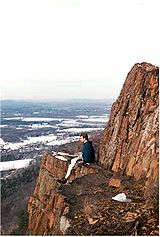
Seven Sisters Seven Sisters (Massachusetts)The Seven Sisters, part of the Holyoke Range and located within the Pioneer Valley region of Massachusetts, are a series of basalt ridgeline knobs between Mount Holyoke and Mount Hitchcock . The knobs offer scenic clifftop views interspersed with oak savanna woodlands...
(no image)
Cultural references
- Mount Holyoke is mentioned in Henry JamesHenry JamesHenry James, OM was an American-born writer, regarded as one of the key figures of 19th-century literary realism. He was the son of Henry James, Sr., a clergyman, and the brother of philosopher and psychologist William James and diarist Alice James....
's 1875 novel Roderick HudsonRoderick HudsonRoderick Hudson is a novel by Henry James. Originally published in 1875 as a serial in The Atlantic Monthly, it is a bildungsroman that traces the development of the title character, a sculptor.-Plot summary:...
, in chapters II and IX.
External links
- J.A. Skinner State Park Map
- Hampshire College mountain biking map of the Holyoke Range
- Berkshire Chapter of the Appalachian Mountain Club
- The Kestrel Trust
- The Valley Land Fund
- Friends of the Mount Holyoke Range
- U.S. Congress New England National Scenic Trail Designation Act.
- NPS brochure for National Scenic Trail proposal.
- Natural resource assessment of the Metacomet Ridge
- Geology of the northern Metacomet Ridge region
- State website for Skinner State Park
- Save The Mountain, a citizen action group
- Guide to the Robert Frost Trail
- Mt. Holyoke - FranklinSites.com Hiking Guide