
.gif)
Sugarloaf Mountain (Franklin County, Massachusetts)
Encyclopedia
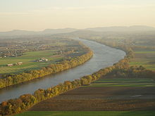
Sugarloaf Mountain or Mount Sugarloaf, is a butte
Butte
A butte is a conspicuous isolated hill with steep, often vertical sides and a small, relatively flat top; it is smaller than mesas, plateaus, and table landform tables. In some regions, such as the north central and northwestern United States, the word is used for any hill...
-like mountain located in Deerfield, Massachusetts
Deerfield, Massachusetts
Deerfield is a town in Franklin County, Massachusetts, United States. The population was 4,750 as of the 2000 census. Deerfield is part of the Springfield, Massachusetts Metropolitan Statistical Area in Western Massachusetts, lying only north of the city of Springfield.Deerfield includes the...
, United States, with two summits, North Sugarloaf Mountain 791 ft (241 m) and its more popular knee, South Sugarloaf Mountain 652 ft (199 m). Its cliffs, made of arkose sandstone
Arkose
Arkose is a detrital sedimentary rock, specifically a type of sandstone containing at least 25% feldspar. Arkosic sand is sand that is similarly rich in feldspar, and thus the potential precursor of arkose....
, are a very prominent landscape feature visible for miles. Despite the low elevation of the summits to the nearby Berkshire Mountains, dramatic cliff faces and a rise of 500 to 600 feet (182.9 m) from the nearby Connecticut River
Connecticut River
The Connecticut River is the largest and longest river in New England, and also an American Heritage River. It flows roughly south, starting from the Fourth Connecticut Lake in New Hampshire. After flowing through the remaining Connecticut Lakes and Lake Francis, it defines the border between the...
make the mountain a popular tourist and hiking destination. Sugarloaf Mountain is the southern terminus of the Pocumtuck Range
Pocumtuck Range
The Pocumtuck Range, also referred to as the Pocumtuck Ridge, is the northern-most subrange of the Metacomet Ridge mountain range of southern New England...
.
Origin of the name
Sugarloaf
A sugarloaf was the traditional form in which refined sugar was produced and sold until the late 19th century when granulated and cube sugars were introduced. A tall cone with a rounded top was the end product of a process that saw the dark molasses-rich raw sugar, which had been imported from...
refers to the loaf-like shape that sugar
Sugar
Sugar is a class of edible crystalline carbohydrates, mainly sucrose, lactose, and fructose, characterized by a sweet flavor.Sucrose in its refined form primarily comes from sugar cane and sugar beet...
was once molded into for shipment. The names Sugarloaf Mountain and Mount Sugarloaf are both used to describe this mountain. USGS sources and published hiking maps refer to (North and South) Sugarloaf Mountain. However, the Massachusetts state reservation encompassing them is called the Mount Sugarloaf State Reservation
Mount Sugarloaf State Reservation
Sugarloaf Mountain State Reservation, managed by the Massachusetts Department of Conservation and Recreation, is located in Deerfield, Massachusetts, just west of the Connecticut River...
. The name Mount Sugarloaf is sometimes used to describe only the south summit, and the north summit is sometimes described as the Pocumtuck Ridge. Both names are used locally.
The original Native American name for the mountain is Wequamps (or Wequomps). The root wehqu- in this name or weckw- in Weckwannuck "Sugarloaf Brook" means "at the point of or extremity of" and occurs in placenames indicating a stopping point. According to native American myth, Sugarloaf Mountain is the carcass of a human-eating giant beaver who lived in a lake now occupied by the Connecticut River. The beaver was killed by the benevolent spirit Hobomock. There may be some truth to this tale; 15,000 years ago the Connecticut River from northern Vermont to southern Connecticut was a post-glacial lake. A now extinct species of giant beaver as big as black bears once inhabited North America at about the same time (see Pocumtuck Range
Pocumtuck Range
The Pocumtuck Range, also referred to as the Pocumtuck Ridge, is the northern-most subrange of the Metacomet Ridge mountain range of southern New England...
for details).
Geology
Sugarloaf Mountain, geologically contiguous with the Pocumtuck Ridge to the north, is composed of sedimentary arkose sandstoneArkose
Arkose is a detrital sedimentary rock, specifically a type of sandstone containing at least 25% feldspar. Arkosic sand is sand that is similarly rich in feldspar, and thus the potential precursor of arkose....
. It is associated with the geologic processes which created the Metacomet Ridge
Metacomet Ridge
The Metacomet Ridge, Metacomet Ridge Mountains, or Metacomet Range of southern New England, United States, is a narrow and steep fault-block mountain ridge known for its extensive cliff faces, scenic vistas, microclimate ecosystems, and communities of plants considered rare or endangered...
which extends through New England
New England
New England is a region in the northeastern corner of the United States consisting of the six states of Maine, New Hampshire, Vermont, Massachusetts, Rhode Island, and Connecticut...
from Long Island Sound
Long Island Sound
Long Island Sound is an estuary of the Atlantic Ocean, located in the United States between Connecticut to the north and Long Island, New York to the south. The mouth of the Connecticut River at Old Saybrook, Connecticut, empties into the sound. On its western end the sound is bounded by the Bronx...
to the Vermont
Vermont
Vermont is a state in the New England region of the northeastern United States of America. The state ranks 43rd in land area, , and 45th in total area. Its population according to the 2010 census, 630,337, is the second smallest in the country, larger only than Wyoming. It is the only New England...
border. Mount Sugarloaf is the bottom layer of a geologic layer cake. The middle layer is composed basalt
Basalt
Basalt is a common extrusive volcanic rock. It is usually grey to black and fine-grained due to rapid cooling of lava at the surface of a planet. It may be porphyritic containing larger crystals in a fine matrix, or vesicular, or frothy scoria. Unweathered basalt is black or grey...
; it is most visible as part of the geology of the Pocumtuck Ridge to the north. The top (youngest) layer is composed of conglomerate
Conglomerate (geology)
A conglomerate is a rock consisting of individual clasts within a finer-grained matrix that have become cemented together. Conglomerates are sedimentary rocks consisting of rounded fragments and are thus differentiated from breccias, which consist of angular clasts...
(known as Mount Toby Conglomerate), which makes up Mount Toby
Mount Toby
Mount Toby, , is the highest summit of a sprawling collection of mostly wooded hills and knolls that rise from a distinct plateau-like upland in the towns of Sunderland and Leverett, Massachusetts, just east of the Connecticut River. This mountain mass, part of the Metacomet Ridge geology, is oval...
directly across the Connecticut River from Sugarloaf Mountain. About 200 million years ago, as the continent of North America
North America
North America is a continent wholly within the Northern Hemisphere and almost wholly within the Western Hemisphere. It is also considered a northern subcontinent of the Americas...
began rifting apart from Africa
Africa
Africa is the world's second largest and second most populous continent, after Asia. At about 30.2 million km² including adjacent islands, it covers 6% of the Earth's total surface area and 20.4% of the total land area...
and Eurasia
Eurasia
Eurasia is a continent or supercontinent comprising the traditional continents of Europe and Asia ; covering about 52,990,000 km2 or about 10.6% of the Earth's surface located primarily in the eastern and northern hemispheres...
, a series of erosion
Erosion
Erosion is when materials are removed from the surface and changed into something else. It only works by hydraulic actions and transport of solids in the natural environment, and leads to the deposition of these materials elsewhere...
and deposition episodes interspersed with heavy basalt lava
Lava
Lava refers both to molten rock expelled by a volcano during an eruption and the resulting rock after solidification and cooling. This molten rock is formed in the interior of some planets, including Earth, and some of their satellites. When first erupted from a volcanic vent, lava is a liquid at...
flows created this layer cake. Faulting and earthquakes tilted the layers diagonally; subsequent erosion and glacial activity exposed the tilted "layers" of sandstone, basalt, and erosion-resistant conglomerate visible today. Although not composed of trap rock
Trap rock
Trap rock is a form of igneous rock that tends to form polygonal vertical fractures, most typically hexagonal, but also four to eight sided. The fracture pattern forms when magma of suitable chemical composition intrudes as a sill or extrudes as a thick lava flow, and slowly cools.Because of the...
, Sugarloaf Mountain is a closely associated with the Metacomet Ridge by virtue of its origin via the same rifting and uplift that created those mountains.
Recreation
Pocumtuck Ridge Trail
The Pocumtuck Ridge Trail is a footpath that traverses the Pocumtuck Range of Deerfield and Greenfield, Massachusetts.The trail is known for its dramatic views of the Deerfield River and Connecticut River valleys from extensive cliff faces...
, make the mountain a favorite local hiking destination.
Most of the mountain has been conserved as part of the Mount Sugarloaf State Reservation
Mount Sugarloaf State Reservation
Sugarloaf Mountain State Reservation, managed by the Massachusetts Department of Conservation and Recreation, is located in Deerfield, Massachusetts, just west of the Connecticut River...
. The reservation is easily accessible via Route 116
Massachusetts Route 116
Route 116 is a south–north state highway in Massachusetts. The route runs from Springfield through mill towns, college towns and rural towns, crossing the Connecticut River three times before finally ending in Adams.-Route description:...
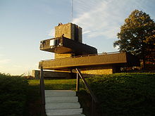
and is only a 15 minute drive from the University of Massachusetts, Amherst campus. There is parking at the base of the mountain and at the top of the paved road that leads from the parking area to the summit of South Sugarloaf. It is free to hike the trails or climb the road by foot or by bike, but there is a nominal fee for vehicles. North Sugarloaf Mountain is only accessible by foot; a small cave is located just beneath the summit ledges.
Film and television
In Fall 2008, the Mel GibsonMel Gibson
Mel Colm-Cille Gerard Gibson, AO is an American actor, film director, producer and screenwriter. Born in Peekskill, New York, Gibson moved with his parents to Sydney, Australia when he was 12 years old and later studied acting at the Australian National Institute of Dramatic Art.After appearing in...
film Edge of Darkness was filmed at the summit of South Sugarloaf. The observation tower was temporarily renovated for the film.
See also
- Information specific to the Mount Sugarloaf State ReservationMount Sugarloaf State ReservationSugarloaf Mountain State Reservation, managed by the Massachusetts Department of Conservation and Recreation, is located in Deerfield, Massachusetts, just west of the Connecticut River...
.
- Mount SugarloafMount SugarloafMount Sugarloaf, also known as Great Sugar Loaf, is a mountain in the lower Hunter Region of New South Wales, Australia, overlooking the cites of Newcastle, Lake Macquarie, Cessnock and Maitland. The summit of the mountain is in the Lake Macquarie suburb of West Wallsend and access to the summit is...
and Sugarloaf Mountain are also the names of numerous other hills and mountains worldwide. Several nearby mountains with the name "Sugarloaf" are located in MaineMaineMaine is a state in the New England region of the northeastern United States, bordered by the Atlantic Ocean to the east and south, New Hampshire to the west, and the Canadian provinces of Quebec to the northwest and New Brunswick to the northeast. Maine is both the northernmost and easternmost...
, VermontVermontVermont is a state in the New England region of the northeastern United States of America. The state ranks 43rd in land area, , and 45th in total area. Its population according to the 2010 census, 630,337, is the second smallest in the country, larger only than Wyoming. It is the only New England...
, New HampshireNew HampshireNew Hampshire is a state in the New England region of the northeastern United States of America. The state was named after the southern English county of Hampshire. It is bordered by Massachusetts to the south, Vermont to the west, Maine and the Atlantic Ocean to the east, and the Canadian...
, and ConnecticutConnecticutConnecticut is a state in the New England region of the northeastern United States. It is bordered by Rhode Island to the east, Massachusetts to the north, and the state of New York to the west and the south .Connecticut is named for the Connecticut River, the major U.S. river that approximately...
.