
Saltonstall Mountain
Encyclopedia
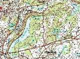
Saltonstall Mountain, also known as Saltonstall Ridge, with a high point of (est.) 320 feet (97.5 m) above sea level, is a traprock mountain ridge located 3 miles (5 km) east of New Haven, Connecticut
and 1.75 miles (2.8 km) north of Long Island Sound. It is part of the Metacomet Ridge
that extends from Long Island Sound
near New Haven, Connecticut
, north through the Connecticut River Valley of Massachusetts
to the Vermont
border. Saltonstall Mountain is known for its 100 feet (30.5 m) scenic cliff faces and sharp ridgeline, unique microclimate
ecosystems, rare plant communities, and for Lake Saltonstall
, a 3 miles (5 km) long by 0.3 miles (400 m) wide municipal reservoir nearly enclosed by the mountain. Saltonstall Mountain is traversed by a number of hiking trails managed by the South Central Connecticut Regional Water Authority
(SCCRWA) and Branford Land Trust.
 Saltonstall Mountain rises steeply 200 feet (61 m) above the surrounding landscape, with a high point of (est.) 320 feet (98 m). It is roughly 5.75 miles (9.3 km) long by 1.25 miles (2 km) miles wide and shaped like a hunting bow
. The mountain lies within the towns of Branford
, North Branford
, and East Haven, Connecticut
. Its western side is steepest, with vertical ledges and talus
slopes, while its eastern side is lower and punctuated by hilly rises. The high point lies at the north end of the mountain; Lake Saltonstall is sanwiched in the mountain's southern arms. Beside Lake Saltonstall, the mountain shelters several other small bodies of water, including Lidyhites Pond, located in the center of the ridge north of Lake Saltonstall; Linsley Pond and Cedar Pond, located at the mountain's northern foot; and the two Branford Supply Ponds, located at the eastern foot. The Farm River runs along the western foot of the mountain. Interstate 95
cuts through the southern tip of the ridge.
The Metacomet Ridge continues north from Saltonstall Mountain as Totoket Mountain
and south as Beacon Hill
where the ridge terminates at Long Island Sound. To the west, the Metacomet Ridge continues from Saltonstall Mountain through urban East Haven and New Haven as a series of parallel traprock rises culminating in East Rock
. An outlying peak, Peter's Rock
, lies to the north-northwest of Saltonstall Mountain.
The west side of Saltonstall Mountain drains into the Farm River, thence to the East Haven River and Long Island Sound; the east side into Pisgah Brook, thence into the Branford River and Long Island Sound.
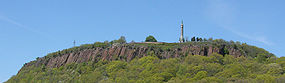
 Saltonstall Mountain, like much of the Metacomet Ridge, is composed of basalt
, also called traprock, a volcanic rock. The mountain formed near the end of the Triassic Period with the rifting apart of the North America
n continent from Africa
and Eurasia
. Lava
welled up from the rift and solidified into sheets of strata hundreds of feet thick. Subsequent faulting and earthquake
activity tilted the strata, creating the cliffs and ridgeline of Saltonstall Mountain. Hot, dry upper slopes, cool, moist ravines, and mineral-rich ledges of basalt talus
produce a combination of microclimate
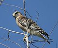
ecosystems on the mountain that support plant and animal species uncommon in greater Connecticut. Examples rare plant and animal species (protected by the state of Connecticut) that live on Saltonstall Mountain include the Eastern Box Turtle, Red-shouldered Hawk
, and Violet Wood Sorrel
. Saltonstall Mountain is also an important raptor migration path. (See Metacomet Ridge
for more information on the geology and ecosystem of Saltonstall Mountain).
, bicycling, picnicking, snowshoeing, and other passive activities. Notable trails include an interpretive nature trail and a dead-end ridgeline trail with precipitous views to the west. The 28 miles (45.1 km) Branford Trail, a recreational footpath that loops around the town of Branford and visits the town's many conservation properties, passes through the east side of the SCCRWA watershed property. Fishing and boating (using the SCCRWA's boats only) are allowed on Lake Saltonstall, where the SCCRWA manages a boat rental shop and handicap accessible fishing pier in season. Swimming and dogs are prohibited, and most of the southernmost 0.5 miles (804.7 m) of the mountain is off limits to the public.
The northern half of the mountain is surrounded by suburban subdivisions; a few reach to parts of the ridgeline. Nonetheless, the Branford Land Trust and the town of Branford manage 800 acres (3.2 km²) of protected open space on the north summit and adjoining parts of the mountain. The Branford Trail crosses through these properties. Passive activities such as hiking and picnicking are encouraged. The town of East Haven maintains open frontage on the Farm River at the west base of Saltonstall Mountain where fishing is allowed.
in Branford. A permit is required to park and use the trails or lake. There are two parking areas for the Branford Trail. The first is located on Laurel Hill Road via Brushy Hill Road, 1.25 miles (2 km) north of its junction with Route 1. The second is located on Northford Avenue via Mill Plain Road, 1.2 miles (1.9 km) north of Route 1. Three parking lots for the Branford Supply Ponds trails are located on Chestnut Street and its extension, Short Rocks Road, 0.3 miles (0.5 km) north of Route 1. Permits are not required to use the Branford Trail and Branford Supply Ponds parking areas.
New Haven, Connecticut
New Haven is the second-largest city in Connecticut and the sixth-largest in New England. According to the 2010 Census, New Haven's population increased by 5.0% between 2000 and 2010, a rate higher than that of the State of Connecticut, and higher than that of the state's five largest cities, and...
and 1.75 miles (2.8 km) north of Long Island Sound. It is part of the Metacomet Ridge
Metacomet Ridge
The Metacomet Ridge, Metacomet Ridge Mountains, or Metacomet Range of southern New England, United States, is a narrow and steep fault-block mountain ridge known for its extensive cliff faces, scenic vistas, microclimate ecosystems, and communities of plants considered rare or endangered...
that extends from Long Island Sound
Long Island Sound
Long Island Sound is an estuary of the Atlantic Ocean, located in the United States between Connecticut to the north and Long Island, New York to the south. The mouth of the Connecticut River at Old Saybrook, Connecticut, empties into the sound. On its western end the sound is bounded by the Bronx...
near New Haven, Connecticut
New Haven, Connecticut
New Haven is the second-largest city in Connecticut and the sixth-largest in New England. According to the 2010 Census, New Haven's population increased by 5.0% between 2000 and 2010, a rate higher than that of the State of Connecticut, and higher than that of the state's five largest cities, and...
, north through the Connecticut River Valley of Massachusetts
Massachusetts
The Commonwealth of Massachusetts is a state in the New England region of the northeastern United States of America. It is bordered by Rhode Island and Connecticut to the south, New York to the west, and Vermont and New Hampshire to the north; at its east lies the Atlantic Ocean. As of the 2010...
to the Vermont
Vermont
Vermont is a state in the New England region of the northeastern United States of America. The state ranks 43rd in land area, , and 45th in total area. Its population according to the 2010 census, 630,337, is the second smallest in the country, larger only than Wyoming. It is the only New England...
border. Saltonstall Mountain is known for its 100 feet (30.5 m) scenic cliff faces and sharp ridgeline, unique microclimate
Microclimate
A microclimate is a local atmospheric zone where the climate differs from the surrounding area. The term may refer to areas as small as a few square feet or as large as many square miles...
ecosystems, rare plant communities, and for Lake Saltonstall
Lake Saltonstall
Lake Saltonstall is a long narrow lake located in south-central Connecticut. It covers an area of approximately and is nestled in the center of the trap rock Saltonstall Mountain...
, a 3 miles (5 km) long by 0.3 miles (400 m) wide municipal reservoir nearly enclosed by the mountain. Saltonstall Mountain is traversed by a number of hiking trails managed by the South Central Connecticut Regional Water Authority
South Central Connecticut Regional Water Authority
The South Central Connecticut Regional Water Authority is a public water supply utility in Connecticut, United States.The Authority supplies water in a 15-town region with a population of about 400,000. Historically it was the water supplier in the towns of Bethany, Branford, Cheshire, East Haven,...
(SCCRWA) and Branford Land Trust.
Geography
Bow (weapon)
The bow and arrow is a projectile weapon system that predates recorded history and is common to most cultures.-Description:A bow is a flexible arc that shoots aerodynamic projectiles by means of elastic energy. Essentially, the bow is a form of spring powered by a string or cord...
. The mountain lies within the towns of Branford
Branford, Connecticut
-Landmarks and attractions:Branford has six historic districts that are listed on the U.S. National Register of Historic Places . These include buildings in Federal, Arts and Crafts, and Queen Anne styles of architecture...
, North Branford
North Branford, Connecticut
North Branford is a town in New Haven County, Connecticut, United States. The population was 13,906 at the 2000 census.-Geography:According to the United States Census Bureau, the town has a total area of 26.6 square miles , of which 24.9 square miles is land and 1.7 square miles is water...
, and East Haven, Connecticut
East Haven, Connecticut
East Haven is a town in New Haven County, Connecticut, in the United States. As of the 2000 census, the town population was 28,189. The town is just 3 minutes from downtown New Haven...
. Its western side is steepest, with vertical ledges and talus
Scree
Scree, also called talus, is a term given to an accumulation of broken rock fragments at the base of crags, mountain cliffs, or valley shoulders. Landforms associated with these materials are sometimes called scree slopes or talus piles...
slopes, while its eastern side is lower and punctuated by hilly rises. The high point lies at the north end of the mountain; Lake Saltonstall is sanwiched in the mountain's southern arms. Beside Lake Saltonstall, the mountain shelters several other small bodies of water, including Lidyhites Pond, located in the center of the ridge north of Lake Saltonstall; Linsley Pond and Cedar Pond, located at the mountain's northern foot; and the two Branford Supply Ponds, located at the eastern foot. The Farm River runs along the western foot of the mountain. Interstate 95
Interstate 95 in Connecticut
Interstate 95, the main north–south Interstate Highway on the East Coast of the United States, runs in a general east–west compass direction for 111.57 miles in Connecticut from the Rhode Island state line to the New York State line. I-95 Southbound from East Lyme to the New York State...
cuts through the southern tip of the ridge.
The Metacomet Ridge continues north from Saltonstall Mountain as Totoket Mountain
Totoket Mountain
Totoket Mountain, with a high point of above sea level, is a traprock massif with several distinct summits, located northeast of New Haven, Connecticut. It is part of the Metacomet Ridge that extends from Long Island Sound near New Haven, north through the Connecticut River Valley of...
and south as Beacon Hill
Beacon Hill (Branford, Connecticut)
Beacon Hill, above sea level, is a traprock outcrop located southeast of New Haven, Connecticut overlooking the mouth of the East Haven River 1.2 miles north of Long Island Sound...
where the ridge terminates at Long Island Sound. To the west, the Metacomet Ridge continues from Saltonstall Mountain through urban East Haven and New Haven as a series of parallel traprock rises culminating in East Rock
East Rock
East Rock of south-central Connecticut, United States, with a high point of , is a long trap rock ridge located on the north side of the city of New Haven...
. An outlying peak, Peter's Rock
Peter's Rock
Peter's Rock, also known as Rabbit Rock, Rabbit Hill, Indian Rock and Great Rock, with a high point of above sea level, is a trap rock peak located northeast of downtown New Haven, Connecticut in the town of North Haven...
, lies to the north-northwest of Saltonstall Mountain.
The west side of Saltonstall Mountain drains into the Farm River, thence to the East Haven River and Long Island Sound; the east side into Pisgah Brook, thence into the Branford River and Long Island Sound.
Geology and environment
Basalt
Basalt is a common extrusive volcanic rock. It is usually grey to black and fine-grained due to rapid cooling of lava at the surface of a planet. It may be porphyritic containing larger crystals in a fine matrix, or vesicular, or frothy scoria. Unweathered basalt is black or grey...
, also called traprock, a volcanic rock. The mountain formed near the end of the Triassic Period with the rifting apart of the North America
North America
North America is a continent wholly within the Northern Hemisphere and almost wholly within the Western Hemisphere. It is also considered a northern subcontinent of the Americas...
n continent from Africa
Africa
Africa is the world's second largest and second most populous continent, after Asia. At about 30.2 million km² including adjacent islands, it covers 6% of the Earth's total surface area and 20.4% of the total land area...
and Eurasia
Eurasia
Eurasia is a continent or supercontinent comprising the traditional continents of Europe and Asia ; covering about 52,990,000 km2 or about 10.6% of the Earth's surface located primarily in the eastern and northern hemispheres...
. Lava
Lava
Lava refers both to molten rock expelled by a volcano during an eruption and the resulting rock after solidification and cooling. This molten rock is formed in the interior of some planets, including Earth, and some of their satellites. When first erupted from a volcanic vent, lava is a liquid at...
welled up from the rift and solidified into sheets of strata hundreds of feet thick. Subsequent faulting and earthquake
Earthquake
An earthquake is the result of a sudden release of energy in the Earth's crust that creates seismic waves. The seismicity, seismism or seismic activity of an area refers to the frequency, type and size of earthquakes experienced over a period of time...
activity tilted the strata, creating the cliffs and ridgeline of Saltonstall Mountain. Hot, dry upper slopes, cool, moist ravines, and mineral-rich ledges of basalt talus
Scree
Scree, also called talus, is a term given to an accumulation of broken rock fragments at the base of crags, mountain cliffs, or valley shoulders. Landforms associated with these materials are sometimes called scree slopes or talus piles...
produce a combination of microclimate
Microclimate
A microclimate is a local atmospheric zone where the climate differs from the surrounding area. The term may refer to areas as small as a few square feet or as large as many square miles...
ecosystems on the mountain that support plant and animal species uncommon in greater Connecticut. Examples rare plant and animal species (protected by the state of Connecticut) that live on Saltonstall Mountain include the Eastern Box Turtle, Red-shouldered Hawk
Red-shouldered Hawk
The Red-shouldered Hawk is a medium-sized hawk. Its breeding range spans eastern North America and along the coast of California and northern to northeastern-central Mexico.-Description:...
, and Violet Wood Sorrel
Oxalis violacea
Oxalis violacea, the violet woodsorrel, is a perennial plant native to the United States. Similar in appearance to small clovers such as the shamrock, the plant bears violet colored flowers among three-parted leaves having heart-shaped leaflets. Wood sorrel emerges in early spring from an...
. Saltonstall Mountain is also an important raptor migration path. (See Metacomet Ridge
Metacomet Ridge
The Metacomet Ridge, Metacomet Ridge Mountains, or Metacomet Range of southern New England, United States, is a narrow and steep fault-block mountain ridge known for its extensive cliff faces, scenic vistas, microclimate ecosystems, and communities of plants considered rare or endangered...
for more information on the geology and ecosystem of Saltonstall Mountain).
Conservation and recreation
The southern half of the mountain is protected as public watershed managed by the SCCRWA. The SCCRWA maintains a number of hiking trails and pedestrian/bicycle roads on the ridge and along the shore of Lake Saltonstall. A permit (good for a year, fee charged), available from the SCCRWA, is required to visit the property. Permitted activities on the mountain include hikingHiking
Hiking is an outdoor activity which consists of walking in natural environments, often in mountainous or other scenic terrain. People often hike on hiking trails. It is such a popular activity that there are numerous hiking organizations worldwide. The health benefits of different types of hiking...
, bicycling, picnicking, snowshoeing, and other passive activities. Notable trails include an interpretive nature trail and a dead-end ridgeline trail with precipitous views to the west. The 28 miles (45.1 km) Branford Trail, a recreational footpath that loops around the town of Branford and visits the town's many conservation properties, passes through the east side of the SCCRWA watershed property. Fishing and boating (using the SCCRWA's boats only) are allowed on Lake Saltonstall, where the SCCRWA manages a boat rental shop and handicap accessible fishing pier in season. Swimming and dogs are prohibited, and most of the southernmost 0.5 miles (804.7 m) of the mountain is off limits to the public.
The northern half of the mountain is surrounded by suburban subdivisions; a few reach to parts of the ridgeline. Nonetheless, the Branford Land Trust and the town of Branford manage 800 acres (3.2 km²) of protected open space on the north summit and adjoining parts of the mountain. The Branford Trail crosses through these properties. Passive activities such as hiking and picnicking are encouraged. The town of East Haven maintains open frontage on the Farm River at the west base of Saltonstall Mountain where fishing is allowed.
Trailheads
The SSCRWA parking lots are located off Hoseley Avenue, 1.9 miles (3.1 km) north of U.S. Route 1U.S. Route 1
U.S. Route 1 is a major north–south U.S. Highway that serves the East Coast of the United States. It runs 2,377 miles from Fort Kent, Maine at the Canadian border south to Key West, Florida. U.S. 1 generally parallels Interstate 95, though it is significantly farther west between...
in Branford. A permit is required to park and use the trails or lake. There are two parking areas for the Branford Trail. The first is located on Laurel Hill Road via Brushy Hill Road, 1.25 miles (2 km) north of its junction with Route 1. The second is located on Northford Avenue via Mill Plain Road, 1.2 miles (1.9 km) north of Route 1. Three parking lots for the Branford Supply Ponds trails are located on Chestnut Street and its extension, Short Rocks Road, 0.3 miles (0.5 km) north of Route 1. Permits are not required to use the Branford Trail and Branford Supply Ponds parking areas.
See also
- Metacomet RidgeMetacomet RidgeThe Metacomet Ridge, Metacomet Ridge Mountains, or Metacomet Range of southern New England, United States, is a narrow and steep fault-block mountain ridge known for its extensive cliff faces, scenic vistas, microclimate ecosystems, and communities of plants considered rare or endangered...
- Lake SaltonstallLake SaltonstallLake Saltonstall is a long narrow lake located in south-central Connecticut. It covers an area of approximately and is nestled in the center of the trap rock Saltonstall Mountain...
- Adjacent summits:
↓ South North ↑ North ↑ < West Beacon Hill Beacon Hill (Branford, Connecticut)Beacon Hill, above sea level, is a traprock outcrop located southeast of New Haven, Connecticut overlooking the mouth of the East Haven River 1.2 miles north of Long Island Sound...
(no image)

External links
- SCCRWA website
- Branford Land Trust
- Town of Branford
- SCCRWA Lake Saltonstall map and brochure.
- Branford Trail map and brochure: Pisgah Brook (north half of Saltonstall Mountain).
- Branford Supply Ponds Trails map and brochure
- Branford Trail map and brochure: Short Beach (Saltonstall Mountain south to Long Island Sound).
- Farm River North map and brochure.