
Talcott Mountain
Encyclopedia
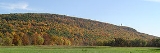
Talcott Montain of central Connecticut
, with a high point of 950 feet (289.6 m), is a 13 miles (20.9 km) long trap rock
mountain ridge located 6 miles (10 km) west of the city of Hartford
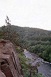
. The ridge, a prominent landscape feature, forms a continuous line of exposed western cliffs visible across the Farmington River
valley from Farmington to Simsbury. Talcott Mountain is part of the narrow, linear Metacomet Ridge
that extends from Long Island Sound
near New Haven, Connecticut
, north through the Connecticut River Valley of Massachusetts
to the Vermont
border.
A popular outdoor recreation resource, Talcott Montain is known for its microclimate
ecosystems, rare plant communities, and expansive views from cliffs that tower up to 700 ft (213 m) above the surrounding landscape.
Talcott Montain encompasses two state parks, several municipal recreation areas and reservoirs, a science center and school, a demonstration forest, and the historic Heublein Tower
. The 51 miles (82.1 km) Metacomet Trail
traverses the ridge.
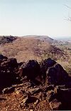 The Talcott Mountain ridgeline, located in Farmington
, West Hartford
, Avon
, Bloomfield
, and Simsbury, Connecticut
, is composed of a tiered series of west facing cliffs punctuated by knobs and peaks. Two of the ridge tiers are distinct along most of the mountain's length; additional tiers manifest themselves over shorter sections of the mountain. Talcott Mountain is 3 miles (5 km) at its widest point. Notable peaks on the ridge include the high point, on which stands the historic Heublein Tower, 950 ft (290 m); Ely Mound, 820 ft (250 m), a conical peak south of the main summit overlooking Ely Pond; Kilkenny Rocks, 730 ft (223 m), an exposed ledge near the southern end of the mountain; King Phillip Mountain, 920 ft (280 m), just north of the main summit; Burnt Hill, 447 ft (136 m), a summit located on the southeast side of the mountain; and The Pinnacle (not to be confused with Pinnacle Rock
of Farmington Connecticut, also part of the Metacomet Ridge to the south), 737 ft (225 m), in Penwood State Park
, just north of the centerpoint of the mountain.
Talcott Montain is an important aquifer serving metropolitan Hartford and several other communities. Notable reservoir
s and other bodies of water on the mountain include: Wash Brook Pond; Lake Louise, a glacial kettle pond with a swamp boardwalk, observation platform, and waterfall; Hartford Reservoirs #'s 1, 2, 3, 5, and 6; Hoe Pond; Ely Pond; Dyke Pond; and Woodridge Lake.
Talcott Montain is traversed by the following roads (from south to north), Connecticut Route 4, U.S. Route 44
, and Connecticut Route 185
. A network of suburban streets climb the southern slopes of the mountain, and a number of communications towers sprout from the summit peaks.
The Metacomet Ridge extends north from Talcott Mountain as Hatchet Hill
and south as Farmington Mountain
. The north and west sides of the mountain drain into the Farmington River
, thence into the Connecticut River
and Long Island Sound. The Farmington River runs along the east base of the mountain, cutting through the Metacomet Ridge between Talcott Mountain and Hatchet Hill at the Tarrifville Gorge. The east side of the mountain drains into the Park River, thence into the Connecticut River and Long Island Sound.
, a fault-block ridge that formed 200 million years ago during the Triassic
and Jurassic
periods. It is composed of trap rock, also known as basalt
, an extrusive volcanic rock. Basalt is a dark colored rock, but the iron within it weathers to a rusty brown when exposed to the air, lending the ledges a distinct reddish appearance. Basalt frequently breaks into octagonal and pentagonal columns, creating a unique "postpile" appearance. Huge slopes made of fractured basalt scree
are visible beneath many of the ledges of Talcott Mountain; they are particularly evident along the base of the lower tier of cliffs west of Heublein Tower. The basalt cliffs are the product of several massive lava
flows hundreds of feet deep that welled up in faults created by the rifting apart of North America
from Eurasia
and Africa
. These basalt floods of lava happened over a period 20 million years. Erosion occurring between the eruptions deposited deep layers of sediment between the lava flows, which eventually lithified into sedimentary rock
. The resulting "layer cake" of basalt and sedimentary sheets eventually faulted and tilted upward. Subsequent erosion wore away the weaker sedimentary layers a faster rate than the basalt layers, leaving the abruptly tilted edges of the basalt sheets exposed, creating the distinct linear ridge and dramatic cliff faces visible today. The best way to imagine this is to picture a layer cake tilted slightly up with some of the frosting (the sedimentary layer) removed in between.
 Talcott Mountain hosts a combination of microclimate
s unusual in New England
. Dry, hot upper ridges support oak savanna
s, often dominated by chestnut oak
and a variety of understory grasses and ferns. Eastern red cedar
, a dry-loving species, clings to the barren edges of cliffs. Cooler east-facing backslopes tend to support extensive stands of eastern hemlock interspersed with the oak-hickory forest
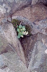
species more common in the surrounding lowlands. Narrow ravines crowded with hemlock block sunlight, creating damp, cooler growing conditions with associated cooler climate plant species. Talus
slopes are especially rich in nutrients and support a number of calcium-loving plants uncommon in eastern Connecticut. Because the trap rock ridges generate such varied terrain, they are the home of several plant and animal species that are state-listed or globally rare.
Infestation by an invasive species
, the Hemlock Woolly Adelgid
, resulted in the death of large stands of mature eastern hemlock in Penwood State Park
on Talcott Mountain. The Connecticut Department of Environmental Protection began a program of removal of dead trees and contaminated living trees in 2000. The infestation and subsequent tree removal dramatically impacted the character of the forests on that part of the mountain.
The massive Pinchot Sycamore
, a champion tree candidate with a trunk 25 ft (8 m) in diameter, is located at the foot of the mountain next to the Farmington River in Simsbury.
Talcott Mountain is also an important seasonal raptor migration path.
 Penwood State Park
and Talcott Mountain State Park
offer miles of paved and dirt park roads (open to pedestrian use only) and a network of trails including the 51 mile (80k) blue-blazed
Metacomet Trail
(maintained by the Connecticut Forest and Park Association
). The parks are open to hiking
, cross-country skiing
, snowshoeing, picnicking, and other passive pursuits. Penwood State Park was donated to the state by Curtis H. Veeder, an industrialist, inventor, and outdoorsperson. Veeder wished the property to "be kept in a natural state so that those who love nature may enjoy this property as I have enjoyed it." He blazed many of the original trails in the park; Lake Louise, a scenic kettle pond atop the ridge, also called Gale Pond, was named after his wife.
The Metropolitan District (MDC), a non-profit municipal corporation chartered by the state of Connecticut, manages more than 3000 acres (12.1 km²) on Talcott Mountain as public water supply, watershed, and open space. Besides providing drinking water, the MDC manages hiking trails and dirt roads (non-motorized use only) and practices silvaculture in the property's forests. MDC lands are open to hiking, picnicking, cross-country skiing, snowshoeing, bicycling, mountain biking
, and other passive activities. The MDC also manages an interpretive trail and has been active in helping to establish bald eagle
populations on the property. Swimming, boating
, hunting
and fishing
are prohibited on MDC lands.
Batterson Park, an urban park located on the southeast side of the mountain in West Hartford next to Hartford Reservoir #1, offers a baseball field, picnic areas, playgrounds, a fresh swimming pond, and a boat launch. The towns of Bloomfield and Simsbury own considerable acreage on the northeast and northwest sides of the mountain including town parks and watershed lands. The town of Farmington owns part of Burnt Hill on the southeast side of the mountain; a rough trail navigates it. The town of Avon owns park space on the west side of the mountain as well as significant frontage on the Farmington River at the base of the mountain.
 The centerpiece of Talcott Mountain State Park is Heublein Tower
, accessible by trail only (1.25 miles (2 km), 30 to 40 minute hike). The tower, 165 ft (50 m) tall and 1040 ft (317 m) above sea level, built for Gilbert F. Hueblein in 1914 as a summer retreat and home, was designed to withstand winds of 100 mph (160 km/h). Ownership of the property passed to the Hartford Times newspaper during World War II
, and, in the 1950s, was used primarily as a radio beacon. Put up for sale in the 1960s and slated for residential development, the tower became part of the Talcott Mountain State Park in 1965 through the efforts of conservation non-profit groups, the state of Connecticut and the United States
government. The tower has been renovated as a museum with period artifacts and furnishings. Visitors may climb to the top of the tower for a 360° view encompassing four states. The tower is open for tours Memorial Day
to Labor Day
, Thursday through Sunday, 10 am to 5 pm; Labor Day through the end of October, 10 am to 5 pm.
In 2000, Talcott Mountain was included in a study by the National Park Service
for the designation of a new National Scenic Trail
now tentatively called the New England National Scenic Trail
, which would include the Metacomet-Monadnock Trail
in Massachusetts and the Mattabesett Trail
and Metacomet Trail
trails in Connecticut.
The Talcott Mountain Science Center
, a regional non-profit education and research facility, located atop the ridge, offers a variety of programs including geology
, ecology
, astronomy
, and meteorology
geared toward children.
A number of regional and local non-profit organizations are active in conserving the landscape and ecosystems of Talcott Mountain, most notably the Connecticut Forest and Park Association
, Simsbury Land Trust, Avon Land Trust, and the Farmington Land Trust.
Connecticut
Connecticut is a state in the New England region of the northeastern United States. It is bordered by Rhode Island to the east, Massachusetts to the north, and the state of New York to the west and the south .Connecticut is named for the Connecticut River, the major U.S. river that approximately...
, with a high point of 950 feet (289.6 m), is a 13 miles (20.9 km) long trap rock
Trap rock
Trap rock is a form of igneous rock that tends to form polygonal vertical fractures, most typically hexagonal, but also four to eight sided. The fracture pattern forms when magma of suitable chemical composition intrudes as a sill or extrudes as a thick lava flow, and slowly cools.Because of the...
mountain ridge located 6 miles (10 km) west of the city of Hartford
Hartford, Connecticut
Hartford is the capital of the U.S. state of Connecticut. The seat of Hartford County until Connecticut disbanded county government in 1960, it is the second most populous city on New England's largest river, the Connecticut River. As of the 2010 Census, Hartford's population was 124,775, making...
. The ridge, a prominent landscape feature, forms a continuous line of exposed western cliffs visible across the Farmington River
Farmington River
The Farmington River is a river located in northwest Connecticut, with major tributaries extending into southwest Massachusetts. Via its longest branch , the Farmington's length increases to , making it the Connecticut River's longest tributary by a mere over the major river directly to its...
valley from Farmington to Simsbury. Talcott Mountain is part of the narrow, linear Metacomet Ridge
Metacomet Ridge
The Metacomet Ridge, Metacomet Ridge Mountains, or Metacomet Range of southern New England, United States, is a narrow and steep fault-block mountain ridge known for its extensive cliff faces, scenic vistas, microclimate ecosystems, and communities of plants considered rare or endangered...
that extends from Long Island Sound
Long Island Sound
Long Island Sound is an estuary of the Atlantic Ocean, located in the United States between Connecticut to the north and Long Island, New York to the south. The mouth of the Connecticut River at Old Saybrook, Connecticut, empties into the sound. On its western end the sound is bounded by the Bronx...
near New Haven, Connecticut
New Haven, Connecticut
New Haven is the second-largest city in Connecticut and the sixth-largest in New England. According to the 2010 Census, New Haven's population increased by 5.0% between 2000 and 2010, a rate higher than that of the State of Connecticut, and higher than that of the state's five largest cities, and...
, north through the Connecticut River Valley of Massachusetts
Massachusetts
The Commonwealth of Massachusetts is a state in the New England region of the northeastern United States of America. It is bordered by Rhode Island and Connecticut to the south, New York to the west, and Vermont and New Hampshire to the north; at its east lies the Atlantic Ocean. As of the 2010...
to the Vermont
Vermont
Vermont is a state in the New England region of the northeastern United States of America. The state ranks 43rd in land area, , and 45th in total area. Its population according to the 2010 census, 630,337, is the second smallest in the country, larger only than Wyoming. It is the only New England...
border.
A popular outdoor recreation resource, Talcott Montain is known for its microclimate
Microclimate
A microclimate is a local atmospheric zone where the climate differs from the surrounding area. The term may refer to areas as small as a few square feet or as large as many square miles...
ecosystems, rare plant communities, and expansive views from cliffs that tower up to 700 ft (213 m) above the surrounding landscape.
Talcott Montain encompasses two state parks, several municipal recreation areas and reservoirs, a science center and school, a demonstration forest, and the historic Heublein Tower
Heublein Tower
The Heublein Tower located in Talcott Mountain State Park in Connecticut provides panoramic views of the Hartford skyline and the Farmington River Valley that are particularly spectacular in the fall.-Origin:...
. The 51 miles (82.1 km) Metacomet Trail
Metacomet Trail
The Metacomet Trail is a Blue-Blazed hiking trail that traverses the Metacomet Ridge of central Connecticut and is a part of the newly designated New England National Scenic Trail. Despite being easily accessible and close to large population centers, the trail is considered remarkably rugged and...
traverses the ridge.
Geography
Farmington, Connecticut
Farmington is a town located in Hartford County in the Farmington Valley area of central Connecticut in the United States. The population was 25,340 at the 2010 census. It is home to the world headquarters of several large corporations including Carrier Corporation, Otis Elevator Company, and Carvel...
, West Hartford
West Hartford, Connecticut
West Hartford is a town located in Hartford County, Connecticut, United States. The town was incorporated in 1854. Prior to that date, the town was a parish of Hartford....
, Avon
Avon, Connecticut
Avon is a town in the Farmington Valley region of Hartford County, Connecticut, United States. , the town had a population of 18,098.Avon is a suburb of Hartford. Avon Old Farms School, a prestigious boarding school, is located there. In 2005, Avon was named the third-safest town in America by...
, Bloomfield
Bloomfield, Connecticut
Bloomfield is a town in Hartford County, Connecticut, United States. The population was 20,626 at the 2009 census.-Geography:According to the United States Census Bureau, the town has a total area of , of which is land and 0.2 square miles is water.Bloomfield is bordered by Windsor to the...
, and Simsbury, Connecticut
Simsbury, Connecticut
Simsbury is a suburban town in Hartford County, Connecticut, United States. The population was 23,234 at the 2000 census. The town was incorporated as Connecticut's twenty-first town in May 1670.-Early history:...
, is composed of a tiered series of west facing cliffs punctuated by knobs and peaks. Two of the ridge tiers are distinct along most of the mountain's length; additional tiers manifest themselves over shorter sections of the mountain. Talcott Mountain is 3 miles (5 km) at its widest point. Notable peaks on the ridge include the high point, on which stands the historic Heublein Tower, 950 ft (290 m); Ely Mound, 820 ft (250 m), a conical peak south of the main summit overlooking Ely Pond; Kilkenny Rocks, 730 ft (223 m), an exposed ledge near the southern end of the mountain; King Phillip Mountain, 920 ft (280 m), just north of the main summit; Burnt Hill, 447 ft (136 m), a summit located on the southeast side of the mountain; and The Pinnacle (not to be confused with Pinnacle Rock
Pinnacle Rock (Connecticut)
Pinnacle Rock, , is a traprock mountain peak located southwest of Hartford, Connecticut in the towns of Farmington and Plainville.It is part of the narrow, linear Metacomet Ridge that extends from Long Island Sound near New Haven, Connecticut, north through the Connecticut River Valley of...
of Farmington Connecticut, also part of the Metacomet Ridge to the south), 737 ft (225 m), in Penwood State Park
Penwood State Park
Penwood State Park is a state park in Bloomfield, Connecticut. Located on Talcott Mountain, it is contiguous with the north end of Talcott Mountain State Park. The Metacomet Trail runs the entire length of the park, in addition to park trails and paved roads accessible by bike.Penwood State Park...
, just north of the centerpoint of the mountain.
Talcott Montain is an important aquifer serving metropolitan Hartford and several other communities. Notable reservoir
Reservoir
A reservoir , artificial lake or dam is used to store water.Reservoirs may be created in river valleys by the construction of a dam or may be built by excavation in the ground or by conventional construction techniques such as brickwork or cast concrete.The term reservoir may also be used to...
s and other bodies of water on the mountain include: Wash Brook Pond; Lake Louise, a glacial kettle pond with a swamp boardwalk, observation platform, and waterfall; Hartford Reservoirs #'s 1, 2, 3, 5, and 6; Hoe Pond; Ely Pond; Dyke Pond; and Woodridge Lake.
Talcott Montain is traversed by the following roads (from south to north), Connecticut Route 4, U.S. Route 44
U.S. Route 44
U.S. Route 44 is an east–west United States highway that runs for 237 miles through four states in the Northeastern region of the United States. The western terminus is at U.S. Route 209 and New York State Route 55 in Kerhonkson, a hamlet in the Hudson Valley region of New York...
, and Connecticut Route 185
Connecticut Route 185
Route 185 is a Connecticut state highway in the western Hartford suburbs, running from Simsbury to West Hartford.-Route description:Route 185 begins as Hartford Road at an intersection with US 202 and Route 10 in the Weatogue section of Simsbury...
. A network of suburban streets climb the southern slopes of the mountain, and a number of communications towers sprout from the summit peaks.
The Metacomet Ridge extends north from Talcott Mountain as Hatchet Hill
Hatchet Hill
Hatchet Hill, est. , is a trap rock ridge located in East Granby, Connecticut, northeast of Hartford, Connecticut. It is part of the narrow, linear Metacomet Ridge that extends from Long Island Sound near New Haven, Connecticut, north through the Connecticut River Valley of Massachusetts to the...
and south as Farmington Mountain
Farmington Mountain
Farmington Mountain, , is a traprock ridge located southwest of Hartford, Connecticut in the town of Farmington. It is part of the narrow, linear Metacomet Ridge that extends from Long Island Sound near New Haven, Connecticut, north through the Connecticut River Valley of Massachusetts to the...
. The north and west sides of the mountain drain into the Farmington River
Farmington River
The Farmington River is a river located in northwest Connecticut, with major tributaries extending into southwest Massachusetts. Via its longest branch , the Farmington's length increases to , making it the Connecticut River's longest tributary by a mere over the major river directly to its...
, thence into the Connecticut River
Connecticut River
The Connecticut River is the largest and longest river in New England, and also an American Heritage River. It flows roughly south, starting from the Fourth Connecticut Lake in New Hampshire. After flowing through the remaining Connecticut Lakes and Lake Francis, it defines the border between the...
and Long Island Sound. The Farmington River runs along the east base of the mountain, cutting through the Metacomet Ridge between Talcott Mountain and Hatchet Hill at the Tarrifville Gorge. The east side of the mountain drains into the Park River, thence into the Connecticut River and Long Island Sound.
Geology
Talcott Montain is a high point on the Metacomet RidgeMetacomet Ridge
The Metacomet Ridge, Metacomet Ridge Mountains, or Metacomet Range of southern New England, United States, is a narrow and steep fault-block mountain ridge known for its extensive cliff faces, scenic vistas, microclimate ecosystems, and communities of plants considered rare or endangered...
, a fault-block ridge that formed 200 million years ago during the Triassic
Triassic
The Triassic is a geologic period and system that extends from about 250 to 200 Mya . As the first period of the Mesozoic Era, the Triassic follows the Permian and is followed by the Jurassic. Both the start and end of the Triassic are marked by major extinction events...
and Jurassic
Jurassic
The Jurassic is a geologic period and system that extends from about Mya to Mya, that is, from the end of the Triassic to the beginning of the Cretaceous. The Jurassic constitutes the middle period of the Mesozoic era, also known as the age of reptiles. The start of the period is marked by...
periods. It is composed of trap rock, also known as basalt
Basalt
Basalt is a common extrusive volcanic rock. It is usually grey to black and fine-grained due to rapid cooling of lava at the surface of a planet. It may be porphyritic containing larger crystals in a fine matrix, or vesicular, or frothy scoria. Unweathered basalt is black or grey...
, an extrusive volcanic rock. Basalt is a dark colored rock, but the iron within it weathers to a rusty brown when exposed to the air, lending the ledges a distinct reddish appearance. Basalt frequently breaks into octagonal and pentagonal columns, creating a unique "postpile" appearance. Huge slopes made of fractured basalt scree
Scree
Scree, also called talus, is a term given to an accumulation of broken rock fragments at the base of crags, mountain cliffs, or valley shoulders. Landforms associated with these materials are sometimes called scree slopes or talus piles...
are visible beneath many of the ledges of Talcott Mountain; they are particularly evident along the base of the lower tier of cliffs west of Heublein Tower. The basalt cliffs are the product of several massive lava
Lava
Lava refers both to molten rock expelled by a volcano during an eruption and the resulting rock after solidification and cooling. This molten rock is formed in the interior of some planets, including Earth, and some of their satellites. When first erupted from a volcanic vent, lava is a liquid at...
flows hundreds of feet deep that welled up in faults created by the rifting apart of North America
North America
North America is a continent wholly within the Northern Hemisphere and almost wholly within the Western Hemisphere. It is also considered a northern subcontinent of the Americas...
from Eurasia
Eurasia
Eurasia is a continent or supercontinent comprising the traditional continents of Europe and Asia ; covering about 52,990,000 km2 or about 10.6% of the Earth's surface located primarily in the eastern and northern hemispheres...
and Africa
Africa
Africa is the world's second largest and second most populous continent, after Asia. At about 30.2 million km² including adjacent islands, it covers 6% of the Earth's total surface area and 20.4% of the total land area...
. These basalt floods of lava happened over a period 20 million years. Erosion occurring between the eruptions deposited deep layers of sediment between the lava flows, which eventually lithified into sedimentary rock
Sedimentary rock
Sedimentary rock are types of rock that are formed by the deposition of material at the Earth's surface and within bodies of water. Sedimentation is the collective name for processes that cause mineral and/or organic particles to settle and accumulate or minerals to precipitate from a solution....
. The resulting "layer cake" of basalt and sedimentary sheets eventually faulted and tilted upward. Subsequent erosion wore away the weaker sedimentary layers a faster rate than the basalt layers, leaving the abruptly tilted edges of the basalt sheets exposed, creating the distinct linear ridge and dramatic cliff faces visible today. The best way to imagine this is to picture a layer cake tilted slightly up with some of the frosting (the sedimentary layer) removed in between.
Ecosystem
Microclimate
A microclimate is a local atmospheric zone where the climate differs from the surrounding area. The term may refer to areas as small as a few square feet or as large as many square miles...
s unusual in New England
New England
New England is a region in the northeastern corner of the United States consisting of the six states of Maine, New Hampshire, Vermont, Massachusetts, Rhode Island, and Connecticut...
. Dry, hot upper ridges support oak savanna
Oak savanna
An oak savanna is a type of savanna, or lightly forested grassland, where oaks are the dominant tree species. These savannas were maintained historically through wildfires set by lightning, grazing, low precipitation, poor soil, and/or fires set by Native Americans...
s, often dominated by chestnut oak
Chestnut oak
Quercus prinus , the chestnut oak, is a species of oak in the white oak group, Quercus sect. Quercus. It is native to the eastern United States, where it is one of the most important ridgetop trees from southern Maine southwest to central Mississippi, with an outlying northwestern population in...
and a variety of understory grasses and ferns. Eastern red cedar
Juniperus virginiana
Juniperus virginiana is a species of juniper native to eastern North America, from southeastern Canada to the Gulf of Mexico, east of the Great Plains...
, a dry-loving species, clings to the barren edges of cliffs. Cooler east-facing backslopes tend to support extensive stands of eastern hemlock interspersed with the oak-hickory forest
Oak-hickory forest
The oak-hickory forest is a general type of North American forest ecosystem with a range extending from southern New England and New York, west to Iowa, and south to Northern Georgia. Smaller, isolated Oak-Hickory communities can also be found as far west as North Dakota, south to Florida and...
species more common in the surrounding lowlands. Narrow ravines crowded with hemlock block sunlight, creating damp, cooler growing conditions with associated cooler climate plant species. Talus
Scree
Scree, also called talus, is a term given to an accumulation of broken rock fragments at the base of crags, mountain cliffs, or valley shoulders. Landforms associated with these materials are sometimes called scree slopes or talus piles...
slopes are especially rich in nutrients and support a number of calcium-loving plants uncommon in eastern Connecticut. Because the trap rock ridges generate such varied terrain, they are the home of several plant and animal species that are state-listed or globally rare.
Infestation by an invasive species
Invasive species
"Invasive species", or invasive exotics, is a nomenclature term and categorization phrase used for flora and fauna, and for specific restoration-preservation processes in native habitats, with several definitions....
, the Hemlock Woolly Adelgid
Hemlock Woolly Adelgid
Hemlock woolly adelgid , commonly abbreviated as HWA, is a true bug native to East Asia that feeds by sucking sap from hemlock trees . In eastern North America, it is a destructive pest that poses a major threat to the eastern hemlock and the Carolina hemlock...
, resulted in the death of large stands of mature eastern hemlock in Penwood State Park
Penwood State Park
Penwood State Park is a state park in Bloomfield, Connecticut. Located on Talcott Mountain, it is contiguous with the north end of Talcott Mountain State Park. The Metacomet Trail runs the entire length of the park, in addition to park trails and paved roads accessible by bike.Penwood State Park...
on Talcott Mountain. The Connecticut Department of Environmental Protection began a program of removal of dead trees and contaminated living trees in 2000. The infestation and subsequent tree removal dramatically impacted the character of the forests on that part of the mountain.
The massive Pinchot Sycamore
Pinchot Sycamore
The Pinchot Sycamore is a large American sycamore in Simsbury, Connecticut. It is the largest tree in Connecticut. When measured by the Connecticut Botanical Society in 1998, the Pinchot Sycamore was 26 feet around and 95 feet tall, with an average canopy diameter of 140 feet...
, a champion tree candidate with a trunk 25 ft (8 m) in diameter, is located at the foot of the mountain next to the Farmington River in Simsbury.
Talcott Mountain is also an important seasonal raptor migration path.
Recreation
Talcott Mountain is a popular outdoor recreation resource among residents and visitors of the metropolitan Hartford region. The mountain boasts a substantial network of hiking trails, clifftop overlooks with expansive views over the rural landscape to the west, rugged woodlands, two small waterfalls, a highland swamp boardwalk, scenic ponds and reservoirs, and a number of active recreation facilities.Penwood State Park
Penwood State Park is a state park in Bloomfield, Connecticut. Located on Talcott Mountain, it is contiguous with the north end of Talcott Mountain State Park. The Metacomet Trail runs the entire length of the park, in addition to park trails and paved roads accessible by bike.Penwood State Park...
and Talcott Mountain State Park
Talcott Mountain State Park
Talcott Mountain State Park is a state park located in Bloomfield, Connecticut. The Heublein Tower, a 165 foot high lookout tower, sits atop Talcott Mountain. The Tower Trail is 1.25 miles long; a walk to the Tower takes approximately 30 – 40 minutes. Also running through the park is a section of...
offer miles of paved and dirt park roads (open to pedestrian use only) and a network of trails including the 51 mile (80k) blue-blazed
Blue-Blazed Trails
The Blue-Blazed trail system, managed by the Connecticut Forest and Park Association, and the related trail systems documented in the two volume 19th Edition of the "Connecticut Walk Book" comprise over 800 miles of hiking trails in Connecticut.There are now over 825 miles of CFPA Blue-Blazed...
Metacomet Trail
Metacomet Trail
The Metacomet Trail is a Blue-Blazed hiking trail that traverses the Metacomet Ridge of central Connecticut and is a part of the newly designated New England National Scenic Trail. Despite being easily accessible and close to large population centers, the trail is considered remarkably rugged and...
(maintained by the Connecticut Forest and Park Association
Connecticut Forest and Park Association
The Connecticut Forest and Park Association , established in 1895, is the oldest private, nonprofit conservation organization in Connecticut. The organization is credited as an important early pioneer of the national land conservation movement and as an early advocate of long distance trail building...
). The parks are open to hiking
Hiking
Hiking is an outdoor activity which consists of walking in natural environments, often in mountainous or other scenic terrain. People often hike on hiking trails. It is such a popular activity that there are numerous hiking organizations worldwide. The health benefits of different types of hiking...
, cross-country skiing
Cross-country skiing
Cross-country skiing is a winter sport in which participants propel themselves across snow-covered terrain using skis and poles...
, snowshoeing, picnicking, and other passive pursuits. Penwood State Park was donated to the state by Curtis H. Veeder, an industrialist, inventor, and outdoorsperson. Veeder wished the property to "be kept in a natural state so that those who love nature may enjoy this property as I have enjoyed it." He blazed many of the original trails in the park; Lake Louise, a scenic kettle pond atop the ridge, also called Gale Pond, was named after his wife.
The Metropolitan District (MDC), a non-profit municipal corporation chartered by the state of Connecticut, manages more than 3000 acres (12.1 km²) on Talcott Mountain as public water supply, watershed, and open space. Besides providing drinking water, the MDC manages hiking trails and dirt roads (non-motorized use only) and practices silvaculture in the property's forests. MDC lands are open to hiking, picnicking, cross-country skiing, snowshoeing, bicycling, mountain biking
Mountain biking
Mountain biking is a sport which consists of riding bicycles off-road, often over rough terrain, using specially adapted mountain bikes. Mountain bikes share similarities with other bikes, but incorporate features designed to enhance durability and performance in rough terrain.Mountain biking can...
, and other passive activities. The MDC also manages an interpretive trail and has been active in helping to establish bald eagle
Bald Eagle
The Bald Eagle is a bird of prey found in North America. It is the national bird and symbol of the United States of America. This sea eagle has two known sub-species and forms a species pair with the White-tailed Eagle...
populations on the property. Swimming, boating
Boating
Boating is the leisurely activity of travelling by boat, or the recreational use of a boat whether powerboats, sailboats, or man-powered vessels , focused on the travel itself, as well as sports activities, such as fishing or water skiing...
, hunting
Hunting
Hunting is the practice of pursuing any living thing, usually wildlife, for food, recreation, or trade. In present-day use, the term refers to lawful hunting, as distinguished from poaching, which is the killing, trapping or capture of the hunted species contrary to applicable law...
and fishing
Fishing
Fishing is the activity of trying to catch wild fish. Fish are normally caught in the wild. Techniques for catching fish include hand gathering, spearing, netting, angling and trapping....
are prohibited on MDC lands.
Batterson Park, an urban park located on the southeast side of the mountain in West Hartford next to Hartford Reservoir #1, offers a baseball field, picnic areas, playgrounds, a fresh swimming pond, and a boat launch. The towns of Bloomfield and Simsbury own considerable acreage on the northeast and northwest sides of the mountain including town parks and watershed lands. The town of Farmington owns part of Burnt Hill on the southeast side of the mountain; a rough trail navigates it. The town of Avon owns park space on the west side of the mountain as well as significant frontage on the Farmington River at the base of the mountain.
Heublein Tower
Heublein Tower
The Heublein Tower located in Talcott Mountain State Park in Connecticut provides panoramic views of the Hartford skyline and the Farmington River Valley that are particularly spectacular in the fall.-Origin:...
, accessible by trail only (1.25 miles (2 km), 30 to 40 minute hike). The tower, 165 ft (50 m) tall and 1040 ft (317 m) above sea level, built for Gilbert F. Hueblein in 1914 as a summer retreat and home, was designed to withstand winds of 100 mph (160 km/h). Ownership of the property passed to the Hartford Times newspaper during World War II
World War II
World War II, or the Second World War , was a global conflict lasting from 1939 to 1945, involving most of the world's nations—including all of the great powers—eventually forming two opposing military alliances: the Allies and the Axis...
, and, in the 1950s, was used primarily as a radio beacon. Put up for sale in the 1960s and slated for residential development, the tower became part of the Talcott Mountain State Park in 1965 through the efforts of conservation non-profit groups, the state of Connecticut and the United States
United States
The United States of America is a federal constitutional republic comprising fifty states and a federal district...
government. The tower has been renovated as a museum with period artifacts and furnishings. Visitors may climb to the top of the tower for a 360° view encompassing four states. The tower is open for tours Memorial Day
Memorial Day
Memorial Day is a United States federal holiday observed on the last Monday of May. Formerly known as Decoration Day, it originated after the American Civil War to commemorate the fallen Union soldiers of the Civil War...
to Labor Day
Labor Day
Labor Day is a United States federal holiday observed on the first Monday in September that celebrates the economic and social contributions of workers.-History:...
, Thursday through Sunday, 10 am to 5 pm; Labor Day through the end of October, 10 am to 5 pm.
Conservation and education
Talcott Mountain and its ecosystems are most threatened by suburban sprawl and ridgetop home building. Although extensive tracts of the mountain have been conserved as state park, municipal water supply, or conservation easement, private landowners also hold significant acreage, particularly on the southwest side of the mountain where upscale homes dot the ridge crest, and also on the lower slopes of the north and west sides of the mountain.In 2000, Talcott Mountain was included in a study by the National Park Service
National Park Service
The National Park Service is the U.S. federal agency that manages all national parks, many national monuments, and other conservation and historical properties with various title designations...
for the designation of a new National Scenic Trail
National Scenic Trail
National Scenic Trail is a designation for protected areas in the United States that consist of trails of particular natural beauty.National Scenic Trails were authorized under the National Trails System Act of 1968 along with National Historic Trails and National Recreation Trails...
now tentatively called the New England National Scenic Trail
New England National Scenic Trail
The New England National Scenic Trail is a National Scenic Trail in southern New England, which includes most of the three single trails Metacomet-Monadnock Trail, Mattabesett Trail and Metacomet Trail. After the Metacomet-Monadnock-Mattabesett trail system, the trail is sometimes called Triple-M...
, which would include the Metacomet-Monadnock Trail
Metacomet-Monadnock Trail
The Metacomet-Monadnock Trail is a hiking trail that traverses the Metacomet Ridge of the Pioneer Valley region of Massachusetts and the central uplands of Massachusetts and southern New Hampshire...
in Massachusetts and the Mattabesett Trail
Mattabesett Trail
The Mattabesett Trail is a long, hook-shaped Blue-Blazed hiking trail in central Connecticut and a part of the newly designated New England National Scenic Trail. One half of the trail follows the high traprock ridges of the Metacomet Ridge, from Totoket Mountain in Guilford, Connecticut to...
and Metacomet Trail
Metacomet Trail
The Metacomet Trail is a Blue-Blazed hiking trail that traverses the Metacomet Ridge of central Connecticut and is a part of the newly designated New England National Scenic Trail. Despite being easily accessible and close to large population centers, the trail is considered remarkably rugged and...
trails in Connecticut.
The Talcott Mountain Science Center
Talcott Mountain Science Center
Talcott Mountain Science Center for Student Involvement is a not-for-profit 501c corporation in Avon, Connecticut. It is dedicated to the improvement of science education and does so by working directly with students, teachers, and the general public.- History :TMSC was established in 1967 under...
, a regional non-profit education and research facility, located atop the ridge, offers a variety of programs including geology
Geology
Geology is the science comprising the study of solid Earth, the rocks of which it is composed, and the processes by which it evolves. Geology gives insight into the history of the Earth, as it provides the primary evidence for plate tectonics, the evolutionary history of life, and past climates...
, ecology
Ecology
Ecology is the scientific study of the relations that living organisms have with respect to each other and their natural environment. Variables of interest to ecologists include the composition, distribution, amount , number, and changing states of organisms within and among ecosystems...
, astronomy
Astronomy
Astronomy is a natural science that deals with the study of celestial objects and phenomena that originate outside the atmosphere of Earth...
, and meteorology
Meteorology
Meteorology is the interdisciplinary scientific study of the atmosphere. Studies in the field stretch back millennia, though significant progress in meteorology did not occur until the 18th century. The 19th century saw breakthroughs occur after observing networks developed across several countries...
geared toward children.
A number of regional and local non-profit organizations are active in conserving the landscape and ecosystems of Talcott Mountain, most notably the Connecticut Forest and Park Association
Connecticut Forest and Park Association
The Connecticut Forest and Park Association , established in 1895, is the oldest private, nonprofit conservation organization in Connecticut. The organization is credited as an important early pioneer of the national land conservation movement and as an early advocate of long distance trail building...
, Simsbury Land Trust, Avon Land Trust, and the Farmington Land Trust.
See also
- Metacomet RidgeMetacomet RidgeThe Metacomet Ridge, Metacomet Ridge Mountains, or Metacomet Range of southern New England, United States, is a narrow and steep fault-block mountain ridge known for its extensive cliff faces, scenic vistas, microclimate ecosystems, and communities of plants considered rare or endangered...
- Metacomet TrailMetacomet TrailThe Metacomet Trail is a Blue-Blazed hiking trail that traverses the Metacomet Ridge of central Connecticut and is a part of the newly designated New England National Scenic Trail. Despite being easily accessible and close to large population centers, the trail is considered remarkably rugged and...
- Farmington RiverFarmington RiverThe Farmington River is a river located in northwest Connecticut, with major tributaries extending into southwest Massachusetts. Via its longest branch , the Farmington's length increases to , making it the Connecticut River's longest tributary by a mere over the major river directly to its...
- Adjacent summits:
↓ South North ↑ 
External links
- Connecticut Forest and Park Association
- U.S. Congress New England National Scenic Trail Designation Act.
- NPS brochure for National Scenic Trail proposal.
- Friends of Heublein Tower
- Talcott Mountain State Park
- Talcott Mountain State Park map
- Penwood State Park map
- Penwood State Park
- MDC Talcott Mountain Reservoir area map
- "Farmington Walking Trails" brochure.
- MDC website
- MDC rules & regulations page
- Town of Simsbury Parks
- Town of Avon parks map
- Avon Land Trust map of Hazen Park
- Avon Land Trust
- Talcott Mountain Science Center
- Simsbury Land Trust
- Farmington Land Trust