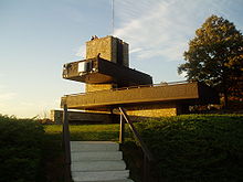
Mount Sugarloaf State Reservation
Encyclopedia

Department of Conservation and Recreation (Massachusetts)
The Department of Conservation and Recreation is a state agency of the Commonwealth of Massachusetts, situated in the Executive Office of Energy and Environmental Affairs. It is best known for its parks and parkways. As of May 24, 2011 the Commissioner of the DCR is Edward M. Lambert, Jr...
, is located in Deerfield, Massachusetts
Deerfield, Massachusetts
Deerfield is a town in Franklin County, Massachusetts, United States. The population was 4,750 as of the 2000 census. Deerfield is part of the Springfield, Massachusetts Metropolitan Statistical Area in Western Massachusetts, lying only north of the city of Springfield.Deerfield includes the...
, just west of the Connecticut River
Connecticut River
The Connecticut River is the largest and longest river in New England, and also an American Heritage River. It flows roughly south, starting from the Fourth Connecticut Lake in New Hampshire. After flowing through the remaining Connecticut Lakes and Lake Francis, it defines the border between the...
. The park includes the summits of North Sugarloaf Mountain and South Sugarloaf Mountain (see Sugarloaf Mountain (Franklin County, Massachusetts)
Sugarloaf Mountain (Franklin County, Massachusetts)
Sugarloaf Mountain or Mount Sugarloaf, is a butte-like mountain located in Deerfield, Massachusetts, United States, with two summits, North Sugarloaf Mountain and its more popular knee, South Sugarloaf Mountain . Its cliffs, made of arkose sandstone, are a very prominent landscape feature visible...
), as well as 1.75 miles of frontage on the Connecticut River and two river islands. The park is part of a larger park designation called the Connecticut River Greenway State Park
Connecticut River Greenway State Park
Connecticut River Greenway State Park consists of a number of separate state land holdings in the Pioneer Valley of western Massachusetts. The park includes critical wildlife and plant habitat as well as areas providing public access to the Connecticut River...
. Portions of the park property along the river are used by the University of Massachusetts Amherst
University of Massachusetts Amherst
The University of Massachusetts Amherst is a public research and land-grant university in Amherst, Massachusetts, United States and the flagship of the University of Massachusetts system...
for agricultural research.
The state maintains an automobile road (nominal fee for cars) and an observation tower on South Sugarloaf, open from late spring through the fall foliage season. The reservation is open for hiking
Hiking
Hiking is an outdoor activity which consists of walking in natural environments, often in mountainous or other scenic terrain. People often hike on hiking trails. It is such a popular activity that there are numerous hiking organizations worldwide. The health benefits of different types of hiking...
, bicycling, canoeing
Canoeing
Canoeing is an outdoor activity that involves a special kind of canoe.Open canoes may be 'poled' , sailed, 'lined and tracked' or even 'gunnel-bobbed'....
, kayaking
Kayaking
Kayaking is the use of a kayak for moving across water. Kayaking and canoeing are also known as paddling. Kayaking is distinguished from canoeing by the sitting position of the paddler and the number of blades on the paddle...
, cross country skiing, snowshoeing, and hunting
Hunting
Hunting is the practice of pursuing any living thing, usually wildlife, for food, recreation, or trade. In present-day use, the term refers to lawful hunting, as distinguished from poaching, which is the killing, trapping or capture of the hunted species contrary to applicable law...
(in season). A number of hiking trails cross the reservation, including the 20-mile Pocumtuck Ridge Trail
Pocumtuck Ridge Trail
The Pocumtuck Ridge Trail is a footpath that traverses the Pocumtuck Range of Deerfield and Greenfield, Massachusetts.The trail is known for its dramatic views of the Deerfield River and Connecticut River valleys from extensive cliff faces...
. Canoe
Canoe
A canoe or Canadian canoe is a small narrow boat, typically human-powered, though it may also be powered by sails or small electric or gas motors. Canoes are usually pointed at both bow and stern and are normally open on top, but can be decked over A canoe (North American English) or Canadian...
and kayak
Kayak
A kayak is a small, relatively narrow, human-powered boat primarily designed to be manually propelled by means of a double blade paddle.The traditional kayak has a covered deck and one or more cockpits, each seating one paddler...
camping is allowed on the islands.
The reservation is easily accessible via Route 116
Massachusetts Route 116
Route 116 is a south–north state highway in Massachusetts. The route runs from Springfield through mill towns, college towns and rural towns, crossing the Connecticut River three times before finally ending in Adams.-Route description:...
and is only a 15 minute drive from the University of Massachusetts Amherst campus. Parking is available at the base of the mountain and at the summit of the auto road.

