
Hanging Hills
Encyclopedia
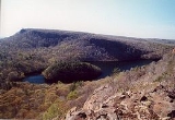
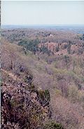
The Hanging Hills of south central Connecticut
, USA are a range of mountainous trap rock
ridges overlooking the city of Meriden
and the Quinnipiac River Valley
900 feet (274 m) below. They are a sub-range of the narrow, linear Metacomet Ridge
that extends from Long Island Sound
near New Haven, Connecticut
, north through the Connecticut River Valley of Massachusetts
to the Vermont
border. A popular outdoor recreation resource, the range is known for its microclimate
ecosystems, rare plant communities, and expansive views from cliffs that rise abruptly over 700 feet (213 m) above the surrounding landscape. The Hanging Hills encompass the 1800 acres (7.3 km²) Hubbard Park
, designed with the help of landscape architect Frederick Law Olmstead The 51 mile (80k) Metacomet Trail
traverses the range.
 Located within the towns of Meriden, Southington
, and Berlin
, the range, roughly horseshoe-shaped with cliff faces oriented south and west, includes, from east to west, Cathole Mountain
515 feet (157 m), South Mountain
767 feet (234 m), East Peak
976 feet (297 m), and West Peak
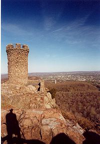
1024 feet (312 m). Castle Craig
is a small stone tower built in 1900 on East Peak. The Metacomet Ridge extends north from the Hanging Hills as Short Mountain
and Ragged Mountain and southeast as Lamentation Mountain
.
The south, east, and west sides of the Hanging Hills drain into the Quinnipiac River
, thence into Long Island Sound
; the north side into the Mattabesett River, to the Connecticut River
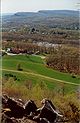
, thence to Long Island Sound. Several notable reservoir
s and natural bodies of water are located within the Hanging Hills or beneath its slopes, including Kenmere Reservoir, Hallmere Reservoir, Elmere Reservoir, Beaver Pond, Silver Lake, Mirror Lake, and Slopers Ponds. Merimere Reservoir, nestled between South Mountain and East Peak and punctuated by the rocky mass of Mine Island, is considered particularly scenic.
was financed by Walter Hubbard, local entrepreneur and president of the Bradley & Hubbard Manufacturing Company. Hubbard elicited the assistance of notable landscape architect Fredrick Law Olmstead in drawing up the design.
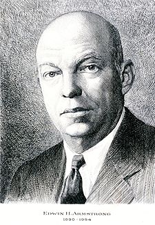
Edwin Howard Armstrong, a network radio pioneer who invented FM radio, used West Peak for the location of one of the first FM radio broadcasts in 1939. His original 70 feet (21 m) tall radio mast still stands on the peak. Currently West Peak is home to six FM broadcast stations, including WPKT, WWYZ, WKSS, WDRC-FM, WPHH and WHCN.
 The fault-block Hanging Hills were formed 200 million years ago during the Triassic
and Jurassic
periods and are composed of trap rock, also known as basalt
, an extrusive volcanic rock. Basalt is a dark colored rock, but the iron within it weathers to a rusty brown when exposed to the air, lending the ledges a distinct reddish appearance. Basalt frequently breaks into octagonal and pentagonal columns, creating a unique "postpile" appearance. Huge slopes made of fractured basalt scree
are visible beneath many of the ledges of the Hanging Hills; they are particularly visible along the base of East Peak where it plunges into Merimere Reservoir. The basalt cliffs are the product of several massive lava
flows hundreds of feet deep that welled up in faults created by the rifting apart of North America
from Eurasia
and Africa
. These basalt floods of lava happened over a period of 20 million years. Erosion occurring between the eruptions deposited deep layers of sediment between the lava flows, which eventually lithified into sedimentary rock
. The resulting "layer cake" of basalt and sedimentary sheets eventually faulted and tilted upward. Subsequent erosion wore away the weaker sedimentary layers a faster rate than the basalt layers, leaving the abruptly tilted edges of the basalt sheets exposed, creating the distinct linear ridge and dramatic cliff faces visible today. The best way to imagine this is to picture a layer cake tilted slightly up with some of the frosting (the sedimentary layer) removed in between. Subsequent scour by moving glacial ice
plucked away the basalt
from the steep southern end of the crest of the broken ridge, creating overhanging cliffs. In the Meriden region, numerous northeast-trending normal faults offset the volcanic flows and intervening sedimentary rocks. Several of these faults break the Metacomet Ridge north of Meriden. Stream erosion and glacial ice carved canyons along these faults, dividing the ridge into the finger-like promontories of the Hanging Hills. Merimere Reservoir was built in the fault-controlled valley between East Peak and South Mountain.
s unusual in New England
. Dry, hot upper ridges support oak savanna
s, often dominated by chestnut oak
and a variety of understory grasses and ferns. Eastern red cedar
, a dry-loving species, clings to the barren edges of cliffs. Cooler north facing backslopes tend to support extensive stands of eastern hemlock interspersed with the oak-hickory forest
species more common in the surrounding lowlands. Narrow ravines crowded with hemlock block sunlight, creating damp, cooler growing conditions with associated cooler climate plant species. Talus slopes are especially rich in nutrients and support a number of calcium-loving plants uncommon in eastern Connecticut. Because the trap rock ridges generate such varied terrain, they are the home of several plant and animal species that are state-listed or globally rare.
The Hanging Hills are also an important seasonal raptor migration path.
(maintained by the Connecticut Forest and Park Association
), traverse the range. Trails are open to hiking
, backcountry skiing
, and snowshoeing; roads are open to bicycling and mountain biking
. Swimming is prohibited. Rock climbing
, prohibited within Hubbard Park, is enjoyed on Cathole Mountain. From the top of the Hanging Hills' many cliffs it is possible to see much of the Quinnipiac River Valley region, Long Island Sound, and the distant higher peaks of southern New England
.
for the designation of a new National Scenic Trail
now tentatively called the New England National Scenic Trail
, which would include the Metacomet-Monadnock Trail
in Massachusetts and the Mattabesett Trail
and Metacomet Trail
trails in Connecticut.
A number of regional and local non-profit organizations are active in conserving the landscape and ecosystems of the Hanging Hills, most notably the Connecticut Forest and Park Association
, the Meriden Land Trust, and the Berlin Land Trust.
for similar legends in other places). Folklore holds that it has haunted the region since the early 19th century and that it manifests as a small black dog, often gregarious in nature, which leaves no footprints and makes no sound. According to the legend, to see the Black Dog the first time results in joy while a second sighting results in misfortune. Seeing the Black Dog a third time is said to be a death omen. At least six deaths have been blamed on third meetings with the Black Dog.
One of the earliest accounts of the dog was published in the Connecticut Quarterly, (April–June, 1898) by New York geologist W.H.C. Pynchon. According to Pynchon, in February 1891 he and geologist Herbert Marshall of the USGS were conducting geologic research in the Hanging Hills when they saw the dog. Pynchon had seen the dog once before. Marshall, who had seen the dog twice, scoffed at the legend. Shortly after the two of them saw the dog, Marshall slipped on the ice atop one of the cliffs and plunged to his death. His body was recovered by authorities. Reports of the Black Dog continue to circulate today.
Adjacent summits:
Connecticut
Connecticut is a state in the New England region of the northeastern United States. It is bordered by Rhode Island to the east, Massachusetts to the north, and the state of New York to the west and the south .Connecticut is named for the Connecticut River, the major U.S. river that approximately...
, USA are a range of mountainous trap rock
Trap rock
Trap rock is a form of igneous rock that tends to form polygonal vertical fractures, most typically hexagonal, but also four to eight sided. The fracture pattern forms when magma of suitable chemical composition intrudes as a sill or extrudes as a thick lava flow, and slowly cools.Because of the...
ridges overlooking the city of Meriden
Meriden, Connecticut
Meriden is a city in New Haven County, Connecticut, United States. According to 2005 Census Bureau estimates, the population of the city is 59,653.-History:...
and the Quinnipiac River Valley
Quinnipiac River
The Quinnipiac River is a river in the New England region of the United States, located entirely in the state of Connecticut.It rises in west central Connecticut from Dead Wood Swamp west of the city of New Britain...
900 feet (274 m) below. They are a sub-range of the narrow, linear Metacomet Ridge
Metacomet Ridge
The Metacomet Ridge, Metacomet Ridge Mountains, or Metacomet Range of southern New England, United States, is a narrow and steep fault-block mountain ridge known for its extensive cliff faces, scenic vistas, microclimate ecosystems, and communities of plants considered rare or endangered...
that extends from Long Island Sound
Long Island Sound
Long Island Sound is an estuary of the Atlantic Ocean, located in the United States between Connecticut to the north and Long Island, New York to the south. The mouth of the Connecticut River at Old Saybrook, Connecticut, empties into the sound. On its western end the sound is bounded by the Bronx...
near New Haven, Connecticut
New Haven, Connecticut
New Haven is the second-largest city in Connecticut and the sixth-largest in New England. According to the 2010 Census, New Haven's population increased by 5.0% between 2000 and 2010, a rate higher than that of the State of Connecticut, and higher than that of the state's five largest cities, and...
, north through the Connecticut River Valley of Massachusetts
Massachusetts
The Commonwealth of Massachusetts is a state in the New England region of the northeastern United States of America. It is bordered by Rhode Island and Connecticut to the south, New York to the west, and Vermont and New Hampshire to the north; at its east lies the Atlantic Ocean. As of the 2010...
to the Vermont
Vermont
Vermont is a state in the New England region of the northeastern United States of America. The state ranks 43rd in land area, , and 45th in total area. Its population according to the 2010 census, 630,337, is the second smallest in the country, larger only than Wyoming. It is the only New England...
border. A popular outdoor recreation resource, the range is known for its microclimate
Microclimate
A microclimate is a local atmospheric zone where the climate differs from the surrounding area. The term may refer to areas as small as a few square feet or as large as many square miles...
ecosystems, rare plant communities, and expansive views from cliffs that rise abruptly over 700 feet (213 m) above the surrounding landscape. The Hanging Hills encompass the 1800 acres (7.3 km²) Hubbard Park
Hubbard Park
Hubbard Park, located in the Hanging Hills of Connecticut, is a wooded, mountainous park located just north of downtown urban Meriden, Connecticut. It comprises approximately of carefully kept woodlands, streams, dramatic cliff faces, flower gardens, and the James Barry bandshell and picnic...
, designed with the help of landscape architect Frederick Law Olmstead The 51 mile (80k) Metacomet Trail
Metacomet Trail
The Metacomet Trail is a Blue-Blazed hiking trail that traverses the Metacomet Ridge of central Connecticut and is a part of the newly designated New England National Scenic Trail. Despite being easily accessible and close to large population centers, the trail is considered remarkably rugged and...
traverses the range.
Geography
Southington, Connecticut
Southington is a town in Hartford County, Connecticut, United States. It is part of Connecticut's 1st congressional district. It is situated about 20 miles southwest of Hartford, about 80 miles northeast of New York City, 105 miles southwest of Boston and 77 miles west of Providence...
, and Berlin
Berlin, Connecticut
Berlin is a town in Hartford County, Connecticut, United States. The population was 19,866 at the 2010 census. It was incorporated in 1785. The geographic center of Connecticut is located in the town. Berlin is residential and industrial, and served by the Amtrak station of the same name...
, the range, roughly horseshoe-shaped with cliff faces oriented south and west, includes, from east to west, Cathole Mountain
Cathole Mountain
Cathole Mountain, , is the lowest peak in the trap rock Hanging Hills of Meriden, Connecticut. The rugged southern ledges of the mountain rise steeply above the city of Meriden...
515 feet (157 m), South Mountain
South Mountain (New Haven County, Connecticut)
South Mountain, , is a prominent traprock peak in the Hanging Hills of Meriden, Connecticut. Rugged and scenic, the peak rises steeply above the city of Meriden below and is characterized by its vertical cliffs and sweeping views of southern Connecticut and Long Island Sound.Most of South Mountain...
767 feet (234 m), East Peak
East Peak (New Haven County, Connecticut)
East Peak, , is a prominent traprock mountain in the Hanging Hills of Meriden, Connecticut. Rugged and scenic, the peak rises steeply above the city of Meriden below and is characterized by its vertical cliffs and sweeping views of southern Connecticut and Long Island Sound...
976 feet (297 m), and West Peak
West Peak (New Haven County, Connecticut)
West Peak, , of the Hanging Hills, is the highest traprock peak in the state of Connecticut. The peak hangs above the city of Meriden below and is characterized by its vertical cliffs and sweeping views of southern Connecticut, Long Island Sound, and the Berkshires to the west...
1024 feet (312 m). Castle Craig
Castle Craig
Castle Craig, located on East Peak in the Hanging Hills, is constructed of trap rock and is in height and has a base in circumference . A metal interior stairway is used to ascend the observation deck on top...
is a small stone tower built in 1900 on East Peak. The Metacomet Ridge extends north from the Hanging Hills as Short Mountain
Short Mountain (Connecticut)
Short Mountain is a traprock mountain located in south central Connecticut north of the city of Meriden. It is part of the narrow Metacomet Ridge that extends from Long Island Sound near New Haven, Connecticut, north through the Connecticut River Valley of Massachusetts to the Vermont border...
and Ragged Mountain and southeast as Lamentation Mountain
Lamentation Mountain
Lamentation Mountain, or Mount Lamentation, , is a traprock mountain located north of Meriden, Connecticut. It is part of the narrow, linear Metacomet Ridge that extends from Long Island Sound near New Haven, Connecticut, north through the Connecticut River Valley of Massachusetts to the Vermont...
.
The south, east, and west sides of the Hanging Hills drain into the Quinnipiac River
Quinnipiac River
The Quinnipiac River is a river in the New England region of the United States, located entirely in the state of Connecticut.It rises in west central Connecticut from Dead Wood Swamp west of the city of New Britain...
, thence into Long Island Sound
Long Island Sound
Long Island Sound is an estuary of the Atlantic Ocean, located in the United States between Connecticut to the north and Long Island, New York to the south. The mouth of the Connecticut River at Old Saybrook, Connecticut, empties into the sound. On its western end the sound is bounded by the Bronx...
; the north side into the Mattabesett River, to the Connecticut River
Connecticut River
The Connecticut River is the largest and longest river in New England, and also an American Heritage River. It flows roughly south, starting from the Fourth Connecticut Lake in New Hampshire. After flowing through the remaining Connecticut Lakes and Lake Francis, it defines the border between the...
, thence to Long Island Sound. Several notable reservoir
Reservoir
A reservoir , artificial lake or dam is used to store water.Reservoirs may be created in river valleys by the construction of a dam or may be built by excavation in the ground or by conventional construction techniques such as brickwork or cast concrete.The term reservoir may also be used to...
s and natural bodies of water are located within the Hanging Hills or beneath its slopes, including Kenmere Reservoir, Hallmere Reservoir, Elmere Reservoir, Beaver Pond, Silver Lake, Mirror Lake, and Slopers Ponds. Merimere Reservoir, nestled between South Mountain and East Peak and punctuated by the rocky mass of Mine Island, is considered particularly scenic.
History
The Hanging Hills' Hubbard ParkHubbard Park
Hubbard Park, located in the Hanging Hills of Connecticut, is a wooded, mountainous park located just north of downtown urban Meriden, Connecticut. It comprises approximately of carefully kept woodlands, streams, dramatic cliff faces, flower gardens, and the James Barry bandshell and picnic...
was financed by Walter Hubbard, local entrepreneur and president of the Bradley & Hubbard Manufacturing Company. Hubbard elicited the assistance of notable landscape architect Fredrick Law Olmstead in drawing up the design.
Edwin Howard Armstrong, a network radio pioneer who invented FM radio, used West Peak for the location of one of the first FM radio broadcasts in 1939. His original 70 feet (21 m) tall radio mast still stands on the peak. Currently West Peak is home to six FM broadcast stations, including WPKT, WWYZ, WKSS, WDRC-FM, WPHH and WHCN.
Geology
Triassic
The Triassic is a geologic period and system that extends from about 250 to 200 Mya . As the first period of the Mesozoic Era, the Triassic follows the Permian and is followed by the Jurassic. Both the start and end of the Triassic are marked by major extinction events...
and Jurassic
Jurassic
The Jurassic is a geologic period and system that extends from about Mya to Mya, that is, from the end of the Triassic to the beginning of the Cretaceous. The Jurassic constitutes the middle period of the Mesozoic era, also known as the age of reptiles. The start of the period is marked by...
periods and are composed of trap rock, also known as basalt
Basalt
Basalt is a common extrusive volcanic rock. It is usually grey to black and fine-grained due to rapid cooling of lava at the surface of a planet. It may be porphyritic containing larger crystals in a fine matrix, or vesicular, or frothy scoria. Unweathered basalt is black or grey...
, an extrusive volcanic rock. Basalt is a dark colored rock, but the iron within it weathers to a rusty brown when exposed to the air, lending the ledges a distinct reddish appearance. Basalt frequently breaks into octagonal and pentagonal columns, creating a unique "postpile" appearance. Huge slopes made of fractured basalt scree
Scree
Scree, also called talus, is a term given to an accumulation of broken rock fragments at the base of crags, mountain cliffs, or valley shoulders. Landforms associated with these materials are sometimes called scree slopes or talus piles...
are visible beneath many of the ledges of the Hanging Hills; they are particularly visible along the base of East Peak where it plunges into Merimere Reservoir. The basalt cliffs are the product of several massive lava
Lava
Lava refers both to molten rock expelled by a volcano during an eruption and the resulting rock after solidification and cooling. This molten rock is formed in the interior of some planets, including Earth, and some of their satellites. When first erupted from a volcanic vent, lava is a liquid at...
flows hundreds of feet deep that welled up in faults created by the rifting apart of North America
North America
North America is a continent wholly within the Northern Hemisphere and almost wholly within the Western Hemisphere. It is also considered a northern subcontinent of the Americas...
from Eurasia
Eurasia
Eurasia is a continent or supercontinent comprising the traditional continents of Europe and Asia ; covering about 52,990,000 km2 or about 10.6% of the Earth's surface located primarily in the eastern and northern hemispheres...
and Africa
Africa
Africa is the world's second largest and second most populous continent, after Asia. At about 30.2 million km² including adjacent islands, it covers 6% of the Earth's total surface area and 20.4% of the total land area...
. These basalt floods of lava happened over a period of 20 million years. Erosion occurring between the eruptions deposited deep layers of sediment between the lava flows, which eventually lithified into sedimentary rock
Sedimentary rock
Sedimentary rock are types of rock that are formed by the deposition of material at the Earth's surface and within bodies of water. Sedimentation is the collective name for processes that cause mineral and/or organic particles to settle and accumulate or minerals to precipitate from a solution....
. The resulting "layer cake" of basalt and sedimentary sheets eventually faulted and tilted upward. Subsequent erosion wore away the weaker sedimentary layers a faster rate than the basalt layers, leaving the abruptly tilted edges of the basalt sheets exposed, creating the distinct linear ridge and dramatic cliff faces visible today. The best way to imagine this is to picture a layer cake tilted slightly up with some of the frosting (the sedimentary layer) removed in between. Subsequent scour by moving glacial ice
Glacier
A glacier is a large persistent body of ice that forms where the accumulation of snow exceeds its ablation over many years, often centuries. At least 0.1 km² in area and 50 m thick, but often much larger, a glacier slowly deforms and flows due to stresses induced by its weight...
plucked away the basalt
Basalt
Basalt is a common extrusive volcanic rock. It is usually grey to black and fine-grained due to rapid cooling of lava at the surface of a planet. It may be porphyritic containing larger crystals in a fine matrix, or vesicular, or frothy scoria. Unweathered basalt is black or grey...
from the steep southern end of the crest of the broken ridge, creating overhanging cliffs. In the Meriden region, numerous northeast-trending normal faults offset the volcanic flows and intervening sedimentary rocks. Several of these faults break the Metacomet Ridge north of Meriden. Stream erosion and glacial ice carved canyons along these faults, dividing the ridge into the finger-like promontories of the Hanging Hills. Merimere Reservoir was built in the fault-controlled valley between East Peak and South Mountain.
Ecosystem
The Hanging Hills host a combination of microclimateMicroclimate
A microclimate is a local atmospheric zone where the climate differs from the surrounding area. The term may refer to areas as small as a few square feet or as large as many square miles...
s unusual in New England
New England
New England is a region in the northeastern corner of the United States consisting of the six states of Maine, New Hampshire, Vermont, Massachusetts, Rhode Island, and Connecticut...
. Dry, hot upper ridges support oak savanna
Oak savanna
An oak savanna is a type of savanna, or lightly forested grassland, where oaks are the dominant tree species. These savannas were maintained historically through wildfires set by lightning, grazing, low precipitation, poor soil, and/or fires set by Native Americans...
s, often dominated by chestnut oak
Chestnut oak
Quercus prinus , the chestnut oak, is a species of oak in the white oak group, Quercus sect. Quercus. It is native to the eastern United States, where it is one of the most important ridgetop trees from southern Maine southwest to central Mississippi, with an outlying northwestern population in...
and a variety of understory grasses and ferns. Eastern red cedar
Juniperus virginiana
Juniperus virginiana is a species of juniper native to eastern North America, from southeastern Canada to the Gulf of Mexico, east of the Great Plains...
, a dry-loving species, clings to the barren edges of cliffs. Cooler north facing backslopes tend to support extensive stands of eastern hemlock interspersed with the oak-hickory forest
Oak-hickory forest
The oak-hickory forest is a general type of North American forest ecosystem with a range extending from southern New England and New York, west to Iowa, and south to Northern Georgia. Smaller, isolated Oak-Hickory communities can also be found as far west as North Dakota, south to Florida and...
species more common in the surrounding lowlands. Narrow ravines crowded with hemlock block sunlight, creating damp, cooler growing conditions with associated cooler climate plant species. Talus slopes are especially rich in nutrients and support a number of calcium-loving plants uncommon in eastern Connecticut. Because the trap rock ridges generate such varied terrain, they are the home of several plant and animal species that are state-listed or globally rare.
The Hanging Hills are also an important seasonal raptor migration path.
Recreation
The Hanging Hills are popular outdoor recreation resource. Hubbard Park features a bandshell and flower gardens and is the site of a variety of local festivals and concerts, most notably the spring Daffodil Festival. A park road leads to Castle Craig Tower and is open from April through October from 10:00 a.m. to 5:00 p.m. A number of trails, most notably the 51 mile (80k) blue-blazed Metacomet TrailMetacomet Trail
The Metacomet Trail is a Blue-Blazed hiking trail that traverses the Metacomet Ridge of central Connecticut and is a part of the newly designated New England National Scenic Trail. Despite being easily accessible and close to large population centers, the trail is considered remarkably rugged and...
(maintained by the Connecticut Forest and Park Association
Connecticut Forest and Park Association
The Connecticut Forest and Park Association , established in 1895, is the oldest private, nonprofit conservation organization in Connecticut. The organization is credited as an important early pioneer of the national land conservation movement and as an early advocate of long distance trail building...
), traverse the range. Trails are open to hiking
Hiking
Hiking is an outdoor activity which consists of walking in natural environments, often in mountainous or other scenic terrain. People often hike on hiking trails. It is such a popular activity that there are numerous hiking organizations worldwide. The health benefits of different types of hiking...
, backcountry skiing
Backcountry skiing
Backcountry skiing is skiing in a sparsely inhabited rural region over ungroomed and unmarked slopes or pistes, including skiing in unmarked or unpatrolled areas either within the ski resort's boundaries or in the backcountry, frequently amongst trees , usually in pursuit of fresh fallen powder...
, and snowshoeing; roads are open to bicycling and mountain biking
Mountain biking
Mountain biking is a sport which consists of riding bicycles off-road, often over rough terrain, using specially adapted mountain bikes. Mountain bikes share similarities with other bikes, but incorporate features designed to enhance durability and performance in rough terrain.Mountain biking can...
. Swimming is prohibited. Rock climbing
Rock climbing
Rock climbing also lightly called 'The Gravity Game', is a sport in which participants climb up, down or across natural rock formations or artificial rock walls. The goal is to reach the summit of a formation or the endpoint of a pre-defined route without falling...
, prohibited within Hubbard Park, is enjoyed on Cathole Mountain. From the top of the Hanging Hills' many cliffs it is possible to see much of the Quinnipiac River Valley region, Long Island Sound, and the distant higher peaks of southern New England
New England
New England is a region in the northeastern corner of the United States consisting of the six states of Maine, New Hampshire, Vermont, Massachusetts, Rhode Island, and Connecticut...
.
Conservation
Much of the Hanging Hills have been conserved as parkland, municipal water supply, or conservation easement. Private landowners also hold significant acreage, particularly on the east and north sides of the range. In 2000, the Hanging Hills were included in a study by the National Park ServiceNational Park Service
The National Park Service is the U.S. federal agency that manages all national parks, many national monuments, and other conservation and historical properties with various title designations...
for the designation of a new National Scenic Trail
National Scenic Trail
National Scenic Trail is a designation for protected areas in the United States that consist of trails of particular natural beauty.National Scenic Trails were authorized under the National Trails System Act of 1968 along with National Historic Trails and National Recreation Trails...
now tentatively called the New England National Scenic Trail
New England National Scenic Trail
The New England National Scenic Trail is a National Scenic Trail in southern New England, which includes most of the three single trails Metacomet-Monadnock Trail, Mattabesett Trail and Metacomet Trail. After the Metacomet-Monadnock-Mattabesett trail system, the trail is sometimes called Triple-M...
, which would include the Metacomet-Monadnock Trail
Metacomet-Monadnock Trail
The Metacomet-Monadnock Trail is a hiking trail that traverses the Metacomet Ridge of the Pioneer Valley region of Massachusetts and the central uplands of Massachusetts and southern New Hampshire...
in Massachusetts and the Mattabesett Trail
Mattabesett Trail
The Mattabesett Trail is a long, hook-shaped Blue-Blazed hiking trail in central Connecticut and a part of the newly designated New England National Scenic Trail. One half of the trail follows the high traprock ridges of the Metacomet Ridge, from Totoket Mountain in Guilford, Connecticut to...
and Metacomet Trail
Metacomet Trail
The Metacomet Trail is a Blue-Blazed hiking trail that traverses the Metacomet Ridge of central Connecticut and is a part of the newly designated New England National Scenic Trail. Despite being easily accessible and close to large population centers, the trail is considered remarkably rugged and...
trails in Connecticut.
A number of regional and local non-profit organizations are active in conserving the landscape and ecosystems of the Hanging Hills, most notably the Connecticut Forest and Park Association
Connecticut Forest and Park Association
The Connecticut Forest and Park Association , established in 1895, is the oldest private, nonprofit conservation organization in Connecticut. The organization is credited as an important early pioneer of the national land conservation movement and as an early advocate of long distance trail building...
, the Meriden Land Trust, and the Berlin Land Trust.
The Black Dog of the Hanging Hills
The Black Dog of the Hanging Hills is an allegedly supernatural hound that appears in local folklore (see also Black dogBlack dog (ghost)
A black dog is the name given to a being found primarily in the folklores of the British Isles. The black dog is essentially a nocturnal apparition, often said to be associated with the Devil, and its appearance was regarded as a portent of death. It is generally supposed to be larger than a normal...
for similar legends in other places). Folklore holds that it has haunted the region since the early 19th century and that it manifests as a small black dog, often gregarious in nature, which leaves no footprints and makes no sound. According to the legend, to see the Black Dog the first time results in joy while a second sighting results in misfortune. Seeing the Black Dog a third time is said to be a death omen. At least six deaths have been blamed on third meetings with the Black Dog.
One of the earliest accounts of the dog was published in the Connecticut Quarterly, (April–June, 1898) by New York geologist W.H.C. Pynchon. According to Pynchon, in February 1891 he and geologist Herbert Marshall of the USGS were conducting geologic research in the Hanging Hills when they saw the dog. Pynchon had seen the dog once before. Marshall, who had seen the dog twice, scoffed at the legend. Shortly after the two of them saw the dog, Marshall slipped on the ice atop one of the cliffs and plunged to his death. His body was recovered by authorities. Reports of the Black Dog continue to circulate today.
See also
- Black dog (ghost)Black dog (ghost)A black dog is the name given to a being found primarily in the folklores of the British Isles. The black dog is essentially a nocturnal apparition, often said to be associated with the Devil, and its appearance was regarded as a portent of death. It is generally supposed to be larger than a normal...
- Metacomet RidgeMetacomet RidgeThe Metacomet Ridge, Metacomet Ridge Mountains, or Metacomet Range of southern New England, United States, is a narrow and steep fault-block mountain ridge known for its extensive cliff faces, scenic vistas, microclimate ecosystems, and communities of plants considered rare or endangered...
- Metacomet TrailMetacomet TrailThe Metacomet Trail is a Blue-Blazed hiking trail that traverses the Metacomet Ridge of central Connecticut and is a part of the newly designated New England National Scenic Trail. Despite being easily accessible and close to large population centers, the trail is considered remarkably rugged and...
- Mattabesett TrailMattabesett TrailThe Mattabesett Trail is a long, hook-shaped Blue-Blazed hiking trail in central Connecticut and a part of the newly designated New England National Scenic Trail. One half of the trail follows the high traprock ridges of the Metacomet Ridge, from Totoket Mountain in Guilford, Connecticut to...
Adjacent summits:
| East > | North ↑ | |
|---|---|---|
 |
 |
|