Totoket Mountain
Encyclopedia
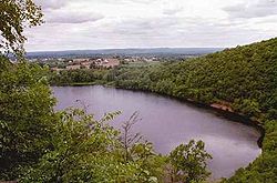
Totoket Mountain, with a high point of (est.) 720 feet (219.5 m) above sea level, is a traprock massif with several distinct summits, located 7 miles (11.3 km) northeast of New Haven, Connecticut
. It is part of the Metacomet Ridge
that extends from Long Island Sound
near New Haven, north through the Connecticut River Valley of Massachusetts
to the Vermont
border. Totoket Mountain is known for its 500 feet (152.4 m) high scenic cliffs, unique microclimate
ecosystems, rare plant communities, and for Lake Gaillard, a 2.5 miles (4 km) wide public reservoir nearly enclosed by the mountain. The north ridge of Totoket Mountain is traversed by the 50 miles (80.5 km) Mattabesett Trail
and a significant network of shorter trails. The name "Totoket Mountain" applies to both the entire mountain and to a subordinate northwestern peak (577 ft (175.9 m)).
 Totoket Mountain rises steeply between 200 ft (61 m) and 650 ft (198 m) above the surrounding landscape, with a high point of (est.) 720 ft (219 m) above sea level. It is roughly 11.5 miles (18.5 km) long by 4.25 mile miles wide at its widest point and lies within the towns of Durham
, North Branford
, and Guilford, Connecticut
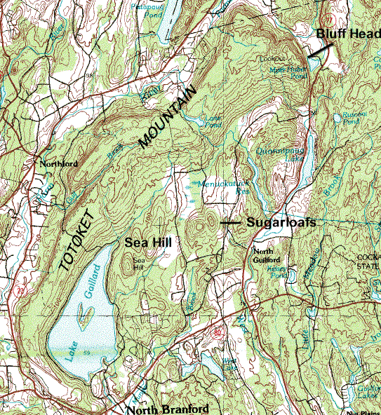
. Major peaks on the mountain include Sea Hill 410 feet (125 m); East and West Sugarloaf Hill, 512 and 476 ft (156.1 and 145.1 ); Totoket Mountain (a subordinate peak), 577 feet (175.9 m); and Bluff Head, est. 720 feet (219.5 m), the high point. The southern half of the mountain splits into two arms which completely encircle the Lake Gaillard Reservoir. Beside Lake Gaillard, the mountain shelters several other small bodies of water, including Menuckatuck Reservoir, West Lake, Clear Lake, Bartlett Pond, Lane Pond, and the scenic Myerhuber Pond (protected as part of the Northwoods conservation area), just below the high cliffs of Bluff Head.
The Metacomet Ridge continues north from Totoket Mountain as Pistapaug Mountain
and south as Saltonstall Mountain
. An outlying peak, Peter's Rock
, lies to the west of Totoket Mountain. The west side of Totoket Mountain drains into the Farm River, thence to the East Haven River and Long Island Sound; the south side into the Branford River and Long Island Sound, the east side into West River and Long Island Sound, and the north side into Parmalee Brook, then to the Coginchaug River
, thence to the Connecticut River
and Long Island Sound.
from Eurasia
in the process that would ultimately create the Atlantic Ocean
. In the area that is now the Metacomet Ridge and surrounding sedimentary rock basin, massive basalt (traprock) lava
flows spread across the prehistoric rift valley
, some of them several hundred feet thick, over a period of 20 million years. Sediment accumulated between lava flows and lithified into sedimentary rock
. After the rifting processes ceased, layers of strata faulted and tilted upward. Subsequent erosion
, glaciation, and uplift exposed the weather resistant edge of the traprock lava sheets, creating the cliffline of the Metacomet Ridge as it is today. The mineral content and the shape of the ridge make possible a variety of microclimate ecosystems. Hot and dry cliff faces support plant and animal species uncommon so far north. Deeply gouged ravines support cooler climate species found in more northerly climes, while gradual backslope environments support species typical of the surrounding latitude. Talus slopes beneath cliffs accumulate minerals that support alkaline-loving plant species uncommon in surrounding acidic southern New England. Extensive cliffs provide ideal habitat and important migration corridors for raptor species.
See Metacomet Ridge
for detailed information about the geology and ecosystem of Totoket Mountain.
, mountain biking
, hunting
(in season), picnicking, fishing
(certain locations only) and snowshoeing; many high cliffs provide excellent views of the rural countryside. The South Central Connecticut Regional Water Authority
(SCCRWA) maintains two networks of trails on Totoket Mountain: Big Gulph on the northwest side of the mountain, and Sugarloaf Hills located in the center of the ridge. An admission permit (fee charged) is required to use these trails. The Northwoods trailhead area is located in the area of Bluff Head, on the northeast side of the mountain; it is maintained by the Guilford Land Trust and is free to the public; 500 ft (152 m) sheer basalt cliffs and a firetower provide sweeping views. The 50 mile (80k) Mattabesett Trail
(managed by the Connecticut Forest and Park Association
), passes over Bluff Head and through the Northwoods area. A fourth tralhead is located in the gap between Pistapaug Mountain and Totoket Mountain.
Much of the mountain has been protected as public watershed. The balance of the landscape is relatively rural, with farmland and semi-rural home development in the center of the ridge and some conservation land on the northeast bluffs. The SCCRWA restricts public access on portions of its watershed property; boating and fishing on Lake Gaillard are prohibited.
Threats to Totoket Mountain and its unique habitat include suburban sprawl and quarrying. A large quarry operates on the southwest side of the mountain, but expansion is restricted by watershed property to the east and housing to the north.
In 2000, the north side of Totoket Mountain was included in a study by the National Park Service
for the designation of a new National Scenic Trail
now tentatively called the New England National Scenic Trail
, which would include the Metacomet-Monadnock Trail
in Massachusetts and the Mattabesett Trail
and Metacomet Trail
trails in Connecticut.
, 3.75 miles (6 km) south of Durham center and 9 miles (14 km) north of Guilford center. The Mattabesett Trail is accessible from this lot and via a trailhead located between Totoket Mountain and Pistapaug Mountain on Connecticut Route 17, 4 miles (6 km) east of Northford center and 3.3 miles (5.3 km) west of the junction of Route 77; parking is permitted along the road. The Big Gulph trailhead is located behind the Northford Park recreation fields on Connecticut Route 17, 2.2 miles (3.5 km) east of Northford center and 5.4 miles (8.7 km) west of the junction of Route 77. Parking is free, but a permit is required to use the trails. The Sugarloaf Hills trailhead and parking lot are located on West Street, 2 miles (3 km) north of its junction with Connecticut Route 80 in North Branford. A permit is required to park and use the trails.
New Haven, Connecticut
New Haven is the second-largest city in Connecticut and the sixth-largest in New England. According to the 2010 Census, New Haven's population increased by 5.0% between 2000 and 2010, a rate higher than that of the State of Connecticut, and higher than that of the state's five largest cities, and...
. It is part of the Metacomet Ridge
Metacomet Ridge
The Metacomet Ridge, Metacomet Ridge Mountains, or Metacomet Range of southern New England, United States, is a narrow and steep fault-block mountain ridge known for its extensive cliff faces, scenic vistas, microclimate ecosystems, and communities of plants considered rare or endangered...
that extends from Long Island Sound
Long Island Sound
Long Island Sound is an estuary of the Atlantic Ocean, located in the United States between Connecticut to the north and Long Island, New York to the south. The mouth of the Connecticut River at Old Saybrook, Connecticut, empties into the sound. On its western end the sound is bounded by the Bronx...
near New Haven, north through the Connecticut River Valley of Massachusetts
Massachusetts
The Commonwealth of Massachusetts is a state in the New England region of the northeastern United States of America. It is bordered by Rhode Island and Connecticut to the south, New York to the west, and Vermont and New Hampshire to the north; at its east lies the Atlantic Ocean. As of the 2010...
to the Vermont
Vermont
Vermont is a state in the New England region of the northeastern United States of America. The state ranks 43rd in land area, , and 45th in total area. Its population according to the 2010 census, 630,337, is the second smallest in the country, larger only than Wyoming. It is the only New England...
border. Totoket Mountain is known for its 500 feet (152.4 m) high scenic cliffs, unique microclimate
Microclimate
A microclimate is a local atmospheric zone where the climate differs from the surrounding area. The term may refer to areas as small as a few square feet or as large as many square miles...
ecosystems, rare plant communities, and for Lake Gaillard, a 2.5 miles (4 km) wide public reservoir nearly enclosed by the mountain. The north ridge of Totoket Mountain is traversed by the 50 miles (80.5 km) Mattabesett Trail
Mattabesett Trail
The Mattabesett Trail is a long, hook-shaped Blue-Blazed hiking trail in central Connecticut and a part of the newly designated New England National Scenic Trail. One half of the trail follows the high traprock ridges of the Metacomet Ridge, from Totoket Mountain in Guilford, Connecticut to...
and a significant network of shorter trails. The name "Totoket Mountain" applies to both the entire mountain and to a subordinate northwestern peak (577 ft (175.9 m)).
Geography
Durham, Connecticut
Durham is a town in Middlesex County, Connecticut, United States. Durham is a former farming village on the Coginchaug River in central Connecticut. The population was 6,627 at the 2000 census. Every autumn, the town hosts the Durham Fair, the largest volunteer agricultural fair in New...
, North Branford
North Branford, Connecticut
North Branford is a town in New Haven County, Connecticut, United States. The population was 13,906 at the 2000 census.-Geography:According to the United States Census Bureau, the town has a total area of 26.6 square miles , of which 24.9 square miles is land and 1.7 square miles is water...
, and Guilford, Connecticut
Guilford, Connecticut
Guilford is a town in New Haven County, Connecticut, United States, that borders Madison, Branford, North Branford and Durham, and is situated on I-95 and the coast. The population was 21,398 at the 2000 census...
. Major peaks on the mountain include Sea Hill 410 feet (125 m); East and West Sugarloaf Hill, 512 and 476 ft (156.1 and 145.1 ); Totoket Mountain (a subordinate peak), 577 feet (175.9 m); and Bluff Head, est. 720 feet (219.5 m), the high point. The southern half of the mountain splits into two arms which completely encircle the Lake Gaillard Reservoir. Beside Lake Gaillard, the mountain shelters several other small bodies of water, including Menuckatuck Reservoir, West Lake, Clear Lake, Bartlett Pond, Lane Pond, and the scenic Myerhuber Pond (protected as part of the Northwoods conservation area), just below the high cliffs of Bluff Head.
The Metacomet Ridge continues north from Totoket Mountain as Pistapaug Mountain
Pistapaug Mountain
Pistapaug Mountain, also known as Paug Mountain, est. , is a traprock mountain located northeast of New Haven, Connecticut. It is part of the narrow, linear Metacomet Ridge that extends from Long Island Sound near New Haven, Connecticut, north through the Connecticut River Valley of Massachusetts...
and south as Saltonstall Mountain
Saltonstall Mountain
Saltonstall Mountain, also known as Saltonstall Ridge, with a high point of above sea level, is a traprock mountain ridge located east of New Haven, Connecticut and north of Long Island Sound. It is part of the Metacomet Ridge that extends from Long Island Sound near New Haven, Connecticut,...
. An outlying peak, Peter's Rock
Peter's Rock
Peter's Rock, also known as Rabbit Rock, Rabbit Hill, Indian Rock and Great Rock, with a high point of above sea level, is a trap rock peak located northeast of downtown New Haven, Connecticut in the town of North Haven...
, lies to the west of Totoket Mountain. The west side of Totoket Mountain drains into the Farm River, thence to the East Haven River and Long Island Sound; the south side into the Branford River and Long Island Sound, the east side into West River and Long Island Sound, and the north side into Parmalee Brook, then to the Coginchaug River
Coginchaug River
The Coginchaug River in Connecticut, with a watershed of including forests, pastures, farmland, industrial, and commercial areas, is the predominant tributary of the Mattabesset River...
, thence to the Connecticut River
Connecticut River
The Connecticut River is the largest and longest river in New England, and also an American Heritage River. It flows roughly south, starting from the Fourth Connecticut Lake in New Hampshire. After flowing through the remaining Connecticut Lakes and Lake Francis, it defines the border between the...
and Long Island Sound.
Geology and environment
The origin of Totoket Mountain and the Metacomet Ridge dates back 200 million years ago with the rifting apart of North AmericaNorth America
North America is a continent wholly within the Northern Hemisphere and almost wholly within the Western Hemisphere. It is also considered a northern subcontinent of the Americas...
from Eurasia
Eurasia
Eurasia is a continent or supercontinent comprising the traditional continents of Europe and Asia ; covering about 52,990,000 km2 or about 10.6% of the Earth's surface located primarily in the eastern and northern hemispheres...
in the process that would ultimately create the Atlantic Ocean
Atlantic Ocean
The Atlantic Ocean is the second-largest of the world's oceanic divisions. With a total area of about , it covers approximately 20% of the Earth's surface and about 26% of its water surface area...
. In the area that is now the Metacomet Ridge and surrounding sedimentary rock basin, massive basalt (traprock) lava
Lava
Lava refers both to molten rock expelled by a volcano during an eruption and the resulting rock after solidification and cooling. This molten rock is formed in the interior of some planets, including Earth, and some of their satellites. When first erupted from a volcanic vent, lava is a liquid at...
flows spread across the prehistoric rift valley
Rift valley
A rift valley is a linear-shaped lowland between highlands or mountain ranges created by the action of a geologic rift or fault. This action is manifest as crustal extension, a spreading apart of the surface which is subsequently further deepened by the forces of erosion...
, some of them several hundred feet thick, over a period of 20 million years. Sediment accumulated between lava flows and lithified into sedimentary rock
Sedimentary rock
Sedimentary rock are types of rock that are formed by the deposition of material at the Earth's surface and within bodies of water. Sedimentation is the collective name for processes that cause mineral and/or organic particles to settle and accumulate or minerals to precipitate from a solution....
. After the rifting processes ceased, layers of strata faulted and tilted upward. Subsequent erosion
Erosion
Erosion is when materials are removed from the surface and changed into something else. It only works by hydraulic actions and transport of solids in the natural environment, and leads to the deposition of these materials elsewhere...
, glaciation, and uplift exposed the weather resistant edge of the traprock lava sheets, creating the cliffline of the Metacomet Ridge as it is today. The mineral content and the shape of the ridge make possible a variety of microclimate ecosystems. Hot and dry cliff faces support plant and animal species uncommon so far north. Deeply gouged ravines support cooler climate species found in more northerly climes, while gradual backslope environments support species typical of the surrounding latitude. Talus slopes beneath cliffs accumulate minerals that support alkaline-loving plant species uncommon in surrounding acidic southern New England. Extensive cliffs provide ideal habitat and important migration corridors for raptor species.
See Metacomet Ridge
Metacomet Ridge
The Metacomet Ridge, Metacomet Ridge Mountains, or Metacomet Range of southern New England, United States, is a narrow and steep fault-block mountain ridge known for its extensive cliff faces, scenic vistas, microclimate ecosystems, and communities of plants considered rare or endangered...
for detailed information about the geology and ecosystem of Totoket Mountain.
Conservation and recreation
Recreational activities enjoyed on the mountain include hikingHiking
Hiking is an outdoor activity which consists of walking in natural environments, often in mountainous or other scenic terrain. People often hike on hiking trails. It is such a popular activity that there are numerous hiking organizations worldwide. The health benefits of different types of hiking...
, mountain biking
Mountain biking
Mountain biking is a sport which consists of riding bicycles off-road, often over rough terrain, using specially adapted mountain bikes. Mountain bikes share similarities with other bikes, but incorporate features designed to enhance durability and performance in rough terrain.Mountain biking can...
, hunting
Hunting
Hunting is the practice of pursuing any living thing, usually wildlife, for food, recreation, or trade. In present-day use, the term refers to lawful hunting, as distinguished from poaching, which is the killing, trapping or capture of the hunted species contrary to applicable law...
(in season), picnicking, fishing
Fishing
Fishing is the activity of trying to catch wild fish. Fish are normally caught in the wild. Techniques for catching fish include hand gathering, spearing, netting, angling and trapping....
(certain locations only) and snowshoeing; many high cliffs provide excellent views of the rural countryside. The South Central Connecticut Regional Water Authority
South Central Connecticut Regional Water Authority
The South Central Connecticut Regional Water Authority is a public water supply utility in Connecticut, United States.The Authority supplies water in a 15-town region with a population of about 400,000. Historically it was the water supplier in the towns of Bethany, Branford, Cheshire, East Haven,...
(SCCRWA) maintains two networks of trails on Totoket Mountain: Big Gulph on the northwest side of the mountain, and Sugarloaf Hills located in the center of the ridge. An admission permit (fee charged) is required to use these trails. The Northwoods trailhead area is located in the area of Bluff Head, on the northeast side of the mountain; it is maintained by the Guilford Land Trust and is free to the public; 500 ft (152 m) sheer basalt cliffs and a firetower provide sweeping views. The 50 mile (80k) Mattabesett Trail
Mattabesett Trail
The Mattabesett Trail is a long, hook-shaped Blue-Blazed hiking trail in central Connecticut and a part of the newly designated New England National Scenic Trail. One half of the trail follows the high traprock ridges of the Metacomet Ridge, from Totoket Mountain in Guilford, Connecticut to...
(managed by the Connecticut Forest and Park Association
Connecticut Forest and Park Association
The Connecticut Forest and Park Association , established in 1895, is the oldest private, nonprofit conservation organization in Connecticut. The organization is credited as an important early pioneer of the national land conservation movement and as an early advocate of long distance trail building...
), passes over Bluff Head and through the Northwoods area. A fourth tralhead is located in the gap between Pistapaug Mountain and Totoket Mountain.
Much of the mountain has been protected as public watershed. The balance of the landscape is relatively rural, with farmland and semi-rural home development in the center of the ridge and some conservation land on the northeast bluffs. The SCCRWA restricts public access on portions of its watershed property; boating and fishing on Lake Gaillard are prohibited.
Threats to Totoket Mountain and its unique habitat include suburban sprawl and quarrying. A large quarry operates on the southwest side of the mountain, but expansion is restricted by watershed property to the east and housing to the north.
In 2000, the north side of Totoket Mountain was included in a study by the National Park Service
National Park Service
The National Park Service is the U.S. federal agency that manages all national parks, many national monuments, and other conservation and historical properties with various title designations...
for the designation of a new National Scenic Trail
National Scenic Trail
National Scenic Trail is a designation for protected areas in the United States that consist of trails of particular natural beauty.National Scenic Trails were authorized under the National Trails System Act of 1968 along with National Historic Trails and National Recreation Trails...
now tentatively called the New England National Scenic Trail
New England National Scenic Trail
The New England National Scenic Trail is a National Scenic Trail in southern New England, which includes most of the three single trails Metacomet-Monadnock Trail, Mattabesett Trail and Metacomet Trail. After the Metacomet-Monadnock-Mattabesett trail system, the trail is sometimes called Triple-M...
, which would include the Metacomet-Monadnock Trail
Metacomet-Monadnock Trail
The Metacomet-Monadnock Trail is a hiking trail that traverses the Metacomet Ridge of the Pioneer Valley region of Massachusetts and the central uplands of Massachusetts and southern New Hampshire...
in Massachusetts and the Mattabesett Trail
Mattabesett Trail
The Mattabesett Trail is a long, hook-shaped Blue-Blazed hiking trail in central Connecticut and a part of the newly designated New England National Scenic Trail. One half of the trail follows the high traprock ridges of the Metacomet Ridge, from Totoket Mountain in Guilford, Connecticut to...
and Metacomet Trail
Metacomet Trail
The Metacomet Trail is a Blue-Blazed hiking trail that traverses the Metacomet Ridge of central Connecticut and is a part of the newly designated New England National Scenic Trail. Despite being easily accessible and close to large population centers, the trail is considered remarkably rugged and...
trails in Connecticut.
Trailheads and parking
The Northwoods-Bluff Head parking lot is located on Connecticut Route 77Connecticut Route 77
Route 77 is a secondary state highway in southern Connecticut. It is a state-designated scenic road and runs from the Guilford town green, through North Guilford, into the town center of Durham.- Route description:...
, 3.75 miles (6 km) south of Durham center and 9 miles (14 km) north of Guilford center. The Mattabesett Trail is accessible from this lot and via a trailhead located between Totoket Mountain and Pistapaug Mountain on Connecticut Route 17, 4 miles (6 km) east of Northford center and 3.3 miles (5.3 km) west of the junction of Route 77; parking is permitted along the road. The Big Gulph trailhead is located behind the Northford Park recreation fields on Connecticut Route 17, 2.2 miles (3.5 km) east of Northford center and 5.4 miles (8.7 km) west of the junction of Route 77. Parking is free, but a permit is required to use the trails. The Sugarloaf Hills trailhead and parking lot are located on West Street, 2 miles (3 km) north of its junction with Connecticut Route 80 in North Branford. A permit is required to park and use the trails.
See also
- Metacomet RidgeMetacomet RidgeThe Metacomet Ridge, Metacomet Ridge Mountains, or Metacomet Range of southern New England, United States, is a narrow and steep fault-block mountain ridge known for its extensive cliff faces, scenic vistas, microclimate ecosystems, and communities of plants considered rare or endangered...
- Adjacent summits:
↓ South North ↑ < West