

Milestone
Encyclopedia
Number
A number is a mathematical object used to count and measure. In mathematics, the definition of number has been extended over the years to include such numbers as zero, negative numbers, rational numbers, irrational numbers, and complex numbers....
ed markers placed along a road
Road
A road is a thoroughfare, route, or way on land between two places, which typically has been paved or otherwise improved to allow travel by some conveyance, including a horse, cart, or motor vehicle. Roads consist of one, or sometimes two, roadways each with one or more lanes and also any...
or boundary
Border
Borders define geographic boundaries of political entities or legal jurisdictions, such as governments, sovereign states, federated states and other subnational entities. Some borders—such as a state's internal administrative borders, or inter-state borders within the Schengen Area—are open and...
at intervals of one mile or occasionally, parts of a mile. They are typically located at the side of the road or in a median
Central reservation
On divided roads, such as divided highways or freeways/motorways, the central reservation , median, parkway , median strip or central nature strip is the area which separates opposing lanes of traffic...
. They are alternatively known as mile markers, mileposts or mile posts (sometimes abbreviated MPs). Mileage is the distance along the road from a fixed commencement point.
Milestones are constructed to provide reference points along the road. This can be used to reassure travel
Travel
Travel is the movement of people or objects between relatively distant geographical locations. 'Travel' can also include relatively short stays between successive movements.-Etymology:...
lers that the proper path is being followed, and to indicate either distance
Distance
Distance is a numerical description of how far apart objects are. In physics or everyday discussion, distance may refer to a physical length, or an estimation based on other criteria . In mathematics, a distance function or metric is a generalization of the concept of physical distance...
travelled or the remaining distance to a destination. Such references are also used to by maintenance engineers and emergency services to direct them to specific points where their presence is required. This term is sometimes used to denote a location on a road even if no physical sign is present. This is useful for accident reporting and other record keeping (e.g., "an accident occurred at the 13 mile mark" even if the road is only marked with a stone once every 10 miles).
Roman Empire
Rock (geology)
In geology, rock or stone is a naturally occurring solid aggregate of minerals and/or mineraloids.The Earth's outer solid layer, the lithosphere, is made of rock. In general rocks are of three types, namely, igneous, sedimentary, and metamorphic...
obelisk
Obelisk
An obelisk is a tall, four-sided, narrow tapering monument which ends in a pyramid-like shape at the top, and is said to resemble a petrified ray of the sun-disk. A pair of obelisks usually stood in front of a pylon...
s – made from granite
Granite
Granite is a common and widely occurring type of intrusive, felsic, igneous rock. Granite usually has a medium- to coarse-grained texture. Occasionally some individual crystals are larger than the groundmass, in which case the texture is known as porphyritic. A granitic rock with a porphyritic...
, marble
Marble
Marble is a metamorphic rock composed of recrystallized carbonate minerals, most commonly calcite or dolomite.Geologists use the term "marble" to refer to metamorphosed limestone; however stonemasons use the term more broadly to encompass unmetamorphosed limestone.Marble is commonly used for...
, or whatever local stone was available – and later concrete
Concrete
Concrete is a composite construction material, composed of cement and other cementitious materials such as fly ash and slag cement, aggregate , water and chemical admixtures.The word concrete comes from the Latin word...
posts. They were widely used by Roman Empire
Roman Empire
The Roman Empire was the post-Republican period of the ancient Roman civilization, characterised by an autocratic form of government and large territorial holdings in Europe and around the Mediterranean....
road builders and were an important part of any Roman road
Roman road
The Roman roads were a vital part of the development of the Roman state, from about 500 BC through the expansion during the Roman Republic and the Roman Empire. Roman roads enabled the Romans to move armies and trade goods and to communicate. The Roman road system spanned more than 400,000 km...
network: the distance travelled per day was only a few miles in some cases. Many Roman milestones only record the name of the reigning emperor without giving any placenames or distances. The first Roman milestones appeared on the Appian way
Appian Way
The Appian Way was one of the earliest and strategically most important Roman roads of the ancient republic. It connected Rome to Brindisi, Apulia, in southeast Italy...
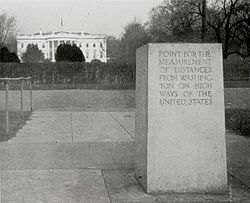
. At the centre of Rome, the "Golden Milestone" was erected to mark the presumed centre of the empire: this milestone has since been lost. The Golden Milestone inspired the Zero Milestone
Zero Milestone
The Zero Milestone is a zero mile marker monument in Washington, D.C. intended as the initial milestone from which all road distances in the United States should be reckoned when it was built. At present, only roads in the Washington, D.C...
in Washington, D.C., intended as the point from which all road distances in the United States should be reckoned.
Byzantine Empire

Constantinople
Constantinople was the capital of the Roman, Eastern Roman, Byzantine, Latin, and Ottoman Empires. Throughout most of the Middle Ages, Constantinople was Europe's largest and wealthiest city.-Names:...
. It served as the starting point for measurement of distances for all the roads leading to the cities of the Byzantine Empire
Byzantine Empire
The Byzantine Empire was the Eastern Roman Empire during the periods of Late Antiquity and the Middle Ages, centred on the capital of Constantinople. Known simply as the Roman Empire or Romania to its inhabitants and neighbours, the Empire was the direct continuation of the Ancient Roman State...
, and had the same function as the Milliarium Aureum of Ancient Rome
Ancient Rome
Ancient Rome was a thriving civilization that grew on the Italian Peninsula as early as the 8th century BC. Located along the Mediterranean Sea and centered on the city of Rome, it expanded to one of the largest empires in the ancient world....
. The Milion survived intact until at least the late 15th century. Its fragments were discovered again in the late 1960s. A fragment is re-erected as a pillar.
Post Medieval Europe
In EuropeEurope
Europe is, by convention, one of the world's seven continents. Comprising the westernmost peninsula of Eurasia, Europe is generally 'divided' from Asia to its east by the watershed divides of the Ural and Caucasus Mountains, the Ural River, the Caspian and Black Seas, and the waterways connecting...
, the distance measured typically starts at specified point within a city
City
A city is a relatively large and permanent settlement. Although there is no agreement on how a city is distinguished from a town within general English language meanings, many cities have a particular administrative, legal, or historical status based on local law.For example, in the U.S...
or town
Town
A town is a human settlement larger than a village but smaller than a city. The size a settlement must be in order to be called a "town" varies considerably in different parts of the world, so that, for example, many American "small towns" seem to British people to be no more than villages, while...
, as many roads were named for the towns at either end. For example in London
London
London is the capital city of :England and the :United Kingdom, the largest metropolitan area in the United Kingdom, and the largest urban zone in the European Union by most measures. Located on the River Thames, London has been a major settlement for two millennia, its history going back to its...
, United Kingdom
United Kingdom
The United Kingdom of Great Britain and Northern IrelandIn the United Kingdom and Dependencies, other languages have been officially recognised as legitimate autochthonous languages under the European Charter for Regional or Minority Languages...
, a plaque near the Eleanor cross
Eleanor cross
The Eleanor crosses were twelve originally wooden, but later lavishly decorated stone, monuments of which three survive intact in a line down part of the east of England. King Edward I had the crosses erected between 1291 and 1294 in memory of his wife Eleanor of Castile, marking the nightly...
at Charing Cross
Charing Cross
Charing Cross denotes the junction of Strand, Whitehall and Cockspur Street, just south of Trafalgar Square in central London, England. It is named after the now demolished Eleanor cross that stood there, in what was once the hamlet of Charing. The site of the cross is now occupied by an equestrian...
is the reference point from which distances from London to other towns and cities are measured. In the UK, milestones are especially associated with former Turnpike roads.
Modern highways
Metal
A metal , is an element, compound, or alloy that is a good conductor of both electricity and heat. Metals are usually malleable and shiny, that is they reflect most of incident light...
signs and in most countries are based on metric rather than imperial units of measure. Also found today are more closely spaced signs containing fractional numbers, and signs along railways, beaches and canals.
United States
In the U.S. Interstate Highway SystemInterstate Highway System
The Dwight D. Eisenhower National System of Interstate and Defense Highways, , is a network of limited-access roads including freeways, highways, and expressways forming part of the National Highway System of the United States of America...
, the numbers usually measure the distance to the southern or western state
U.S. state
A U.S. state is any one of the 50 federated states of the United States of America that share sovereignty with the federal government. Because of this shared sovereignty, an American is a citizen both of the federal entity and of his or her state of domicile. Four states use the official title of...
line, while other highway
Highway
A highway is any public road. In American English, the term is common and almost always designates major roads. In British English, the term designates any road open to the public. Any interconnected set of highways can be variously referred to as a "highway system", a "highway network", or a...
s use the county
County
A county is a jurisdiction of local government in certain modern nations. Historically in mainland Europe, the original French term, comté, and its equivalents in other languages denoted a jurisdiction under the sovereignty of a count A county is a jurisdiction of local government in certain...
line as the benchmark
Benchmark (surveying)
The term bench mark, or benchmark, originates from the chiseled horizontal marks that surveyors made in stone structures, into which an angle-iron could be placed to form a "bench" for a leveling rod, thus ensuring that a leveling rod could be accurately repositioned in the same place in the future...
. Often, the exits are numbered according to the nearest milepost, known as the mile-log system. Some historic and scenic route
Scenic route
A scenic route, tourist road, tourist route, theme route, or scenic byway is a specially designated road or waterway that travels through an area of natural or cultural beauty...
s – such as along the Blue Ridge Parkway
Blue Ridge Parkway
The Blue Ridge Parkway is a National Parkway and All-American Road in the United States, noted for its scenic beauty. It runs for 469 miles , mostly along the famous Blue Ridge, a major mountain chain that is part of the Appalachian Mountains...
in North Carolina
North Carolina
North Carolina is a state located in the southeastern United States. The state borders South Carolina and Georgia to the south, Tennessee to the west and Virginia to the north. North Carolina contains 100 counties. Its capital is Raleigh, and its largest city is Charlotte...
and Virginia
Virginia
The Commonwealth of Virginia , is a U.S. state on the Atlantic Coast of the Southern United States. Virginia is nicknamed the "Old Dominion" and sometimes the "Mother of Presidents" after the eight U.S. presidents born there...
and the Overseas Highway
Overseas Highway
The Overseas Highway is a highway carrying U.S. Route 1 through the Florida Keys. Large parts of it were built on the former right-of-way of the Overseas Railroad, the Key West Extension of the Florida East Coast Railway. Completed in 1912, the Overseas Railroad was heavily damaged and partially...
of the Florida Keys
Florida Keys
The Florida Keys are a coral archipelago in southeast United States. They begin at the southeastern tip of the Florida peninsula, about south of Miami, and extend in a gentle arc south-southwest and then westward to Key West, the westernmost of the inhabited islands, and on to the uninhabited Dry...
– use mileposts to mark points of interest.
India
Milestones on Indian highwaysIndian highways
The National Highways Network of India, is a network of highways that is managed and maintained by agencies of the Government of India. These highways measured over as of 2010, including over of limited-access Expressways....
typically have white backgrounds with yellow tops (on national highways) or green tops (on state highways). The names of cities and distances are painted in black. The names of the nearest towns and cities are written along with distance in kilometres. On undivided highways, both sides of the milestones are used, telling the distance to the nearest cities in each direction. The highway number is written on the head of the milestone. The sum of the distances of two nearest cities in each direction from the milestone is listed on the side.
Zimbabwe
Milestones in ZimbabweZimbabwe
Zimbabwe is a landlocked country located in the southern part of the African continent, between the Zambezi and Limpopo rivers. It is bordered by South Africa to the south, Botswana to the southwest, Zambia and a tip of Namibia to the northwest and Mozambique to the east. Zimbabwe has three...
are still actual stones placed on roadsides and painted white with black markings highlighting the particular distance (in kilometres)
|of the landmark
Landmark
This is a list of landmarks around the world.Landmarks may be split into two categories - natural phenomena and man-made features, like buildings, bridges, statues, public squares and so forth...
from the closest city hall. Given the small size of the country, there is no distinction between state and national road-sign markings.
Australia
Metrication in AustraliaMetrication in Australia
Metrication in Australia took place between 1970 and 1988. Before then, Australia mostly used the imperial system for measurement, which the Australian colonies had inherited from the United Kingdom. Between 1970 and 1988, imperial units were withdrawn from general legal use and replaced with SI...
caused the former mile markers to be gradually replaced with 10 km markers on highways and country roads, and even these have been removed from most major highways with distances to several towns ahead being shown on signboards. Some mile markers are retained as curiosities (see gallery).
Canada
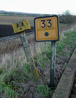
Usage varies by province, as highways are under provincial jurisdiction. In Alberta, for example, kilometre markers are green metal signs with white lettering, and are generally placed every 4 km starting at the last major intersection to the south or west, depending on whether the route runs north-south or east-west.United Kingdom
Although British road signs give distances in miles,British motorways have been marked out in kilometres since the 1980s. Plastic marker posts are installed at 100 m (approximately 5 chain) intervals. Since the advent of the mobile phone, much larger driver location signsDriver location signs
Driver location signs are English highway route markers, first introduced in 2003, that complement distance marker posts. Both types of marker post display the distances from a nominal start point in kilometres...
have been erected to assist drivers when calling the emergency services.
Railway mileposts
"The company shall cause the length of the railway to be measured, and milestones, posts, or other conspicuous objects to be set up and maintained along the whole line thereof, at the distance of one quarter of a mile from each other, with numbers or marks inscribed thereon denoting such distances."
Similar laws were passed in other countries. On the modern railway, these historical markers are still used as infrastructure reference points. At many points, the distances shown on the markers are based upon points no longer on the network – for example, distances measured via a closed line or from a junction which has subsequently been moved. Whole mileposts are usually supplemented by half and quarter posts. Structure signs often include the mileage to a fair degree of precision; in the UK, a chain
Chain (unit)
A chain is a unit of length; it measures 66 feet or 22 yards or 100 links . There are 10 chains in a furlong, and 80 chains in one statute mile. An acre is the area of 10 square chains...
is the usual accuracy. In the U.S. and Canada, miles are "decimalized", so that, for example, there may be a "milepost 4.83" to mark a junction or crossing.
In metricated
Metrication
Metrication refers to the introduction and use of the SI metric system, the international standard for physical measurements. This has involved a long process of independent and systematic conversions of countries from various local systems of weights and measures. Metrication began in France in...
areas, the equivalent is the "point kilométrique
Point kilométrique
Point kilométrique is a French acronym used to measure distances for boundary mileage used mainly in France, on railways, highways, canals, and freeways to help locate a specific location. For example, locations on the Canal du Midi are marked in PK values....
".
Boundaries
SurveyorsSurveying
See Also: Public Land Survey SystemSurveying or land surveying is the technique, profession, and science of accurately determining the terrestrial or three-dimensional position of points and the distances and angles between them...
place milestones to mark the boundaries between the jurisdictions separated by borders. A series of such boundary markers exists at one mile (1.6 km) intervals along the borders of the District of Columbia
Boundary Stones (District of Columbia)
The Boundary Markers of the Original District of Columbia are the 40 milestones that mark the four lines forming the boundaries between the states of Maryland and Virginia and the square of 100 square miles of federal territory that became the District of Columbia in 1801...
in the United States
United States
The United States of America is a federal constitutional republic comprising fifty states and a federal district...
.
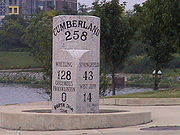
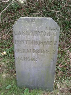
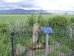
Gallery
See also
- Parting stoneParting stoneA Parting stone is a monument, usually of stone, to either:# Provide direction at a fork in the road -- a parting of the way, or# Commemorate a final parting, as from a loved one.- Directions :...
- Boundary markerBoundary markerA boundary marker, boundary stone or border stone is a robust physical marker that identifies the start of a land boundary or the change in a boundary, especially a change in a direction of a boundary...
- California postmileCalifornia postmileCalifornia uses a postmile system on all of its state highways, including U.S. Routes and Interstate Highways. The postmile markers indicate the distance a route travels through individual counties, as opposed to mile markers that indicate the distance traveled through a state.-Format:A postmile...
- Milepost equationMilepost equationA milepost equation, milepoint equation, or postmile equation is a place where mileposts on a linear feature, such as a highway or rail line, fail to increase normally, usually due to realignment or changes in planned alignment...
- Reassurance markerReassurance markerA reassurance marker or road identification sign is a road sign that repeats the name or number of the current route. Typically posted at intervals alongside a numbered highway, the signs are intended to reassure drivers that they are traveling on the desired road .- North America :In the United...
– a road sign with a route number, but no distance - survey markerSurvey markerSurvey markers, also called survey marks, and sometimes geodetic marks, are objects placed to mark key survey points on the Earth's surface. They are used in geodetic and land surveying. Informally, such marks are referred to as benchmarks, although strictly speaking the term "benchmark" is...
- Highway route markersHighway route markersHighway route markers are the modern-day equivalent of milestones. Unlike traditional milestones, however, which were originally carved from stone and sited at one-mile intervals, modern highway route markers are made from a variety of materials and are almost invariably spaced at intervals of a...
- Kilometre ZeroKilometre ZeroIn many countries, Kilometre Zero or similar terms in other languages, is a particular location , from which distances are traditionally measured...
External links
- The Milestone Society UK
- Mileposts and milestones on the Leeds Liverpool Canal
- Article in Smith's Dictionary of Greek and Roman Antiquities with further links, including to a photograph of a Roman milestone in Orvieto
- Inventory of Roman milestones in France (in French)
- Section 2D.46 of the U.S. Manual on Uniform Traffic Control DevicesManual on Uniform Traffic Control DevicesThe Manual on Uniform Traffic Control Devices is a document issued by the Federal Highway Administration of the United States Department of Transportation to specify the standards by which traffic signs, road surface markings, and signals are designed, installed, and used...
- MileStonesGurus a weblog pictures project with only milestones with an equal KM point