

Road signs in the United Kingdom
Encyclopedia

United Kingdom
The United Kingdom of Great Britain and Northern IrelandIn the United Kingdom and Dependencies, other languages have been officially recognised as legitimate autochthonous languages under the European Charter for Regional or Minority Languages...
conform broadly to Europe
Europe
Europe is, by convention, one of the world's seven continents. Comprising the westernmost peninsula of Eurasia, Europe is generally 'divided' from Asia to its east by the watershed divides of the Ural and Caucasus Mountains, the Ural River, the Caspian and Black Seas, and the waterways connecting...
an norms, though a number of signs are unique to Britain and direction signs omit European route numbers.
History

The rise of Motoring after 1896 saw the pattern repeated. The larger motoring clubs, notably the Automobile Association (AA) and the Royal Scottish Automobile Club (RSAC) erected their own, idiosyncratic warning boards and direction signs on a wide scale. In addition, under the 1903 Motor Act, four national signs were created, supposed to be set at least eight feet from the ground and fifty yards from the reference point. These signs were interesting in being based on shape, rather than text or image; a white ring (speed limited as marked on a small information plate below it; somewhat ironic, given that few vehicles carried speedometers); a white (sometimes red) diamond (a 'motor notice' e.g. weight restriction, given on a plate below); a red disc,(a prohibition); and a red, open triangle (a hazard or warning). These latter two could be given detail by the attachment of an information plate below, but often it was left to the motorist to guess what the sign was referring to and local variations as to the definition of what was a prohibition or just a 'notice', for instance, were common. In spite of this confusing beginning, this format of sign was to develop into the British road sign that was standard from 1934 until 1964. Before this time, until 1933, when regulations for traffic signs were published under powers created by the Road Traffic Act (RTA) of 1930, 'national' road signage specifications were only advisory.
Following a review of 'national' signage in 1921 a limited number of warning/hazard information plates were enhanced by the use of symbols, rather than text only. Such symbols had been developed in continental Europe as early as 1909, but had been dismissed by the UK, which favoured the use of text. The symbols were simple silhouettes, easy to 'read' at a distance. Some were peculiarly British, 'SCHOOL' (and later even 'CHILDREN') depicted by the flaming torch of knowledge, presumably assuming that all motorists were affluent enough to have enjoyed a classical education. Government was to make increasing efforts to standardise road signs in the Road Traffic Act of 1930 and regulations of 1933, being finally consolidated with the publication of the 1934 Road Traffic Acts and Regulations. These saw the end of the very individual black and yellow vitreous enamel AA signs (although the AA was still allowed to erect temporary direction signs, and still does). While the RSAC had ceased erecting signs, the Royal Automobile Club (RAC) had begun to do so to RTA specifications (save for the inclusion of the RAC badge) and was very active in this respect in the late 1930s.
The national British signs were now a red disc (prohibition) a red, open triangle (warning/hazard), a red ring (an order), and a red, open triangle in a ring for the new (1933) warning with order 'SLOW -MAJOR ROAD AHEAD' and 'HALT AT MAJOR ROAD AHEAD' plates. (The predecessors of 'GIVE WAY' and 'STOP'). All signs were to carry information plates mounted below them, the warnings or hazards being illustrated with a wide range of prescribed symbols, but with a text panel below, being only text where no symbol existed. Lettering and symbols were black on a white ground except for orders (e.g. TURN LEFT) , which were white on blue. New to the UK were the first combination sign, which incorporated information on the sign itself, the 30 miles per hour speed restriction (introduced in 1934), '30' in black letters on a white disc (the information) surrounded by a red ring (the order sign). It was accompanied by its 'derestriction' a white disc with a diagonal black band bisecting it. Neither of these signs required separate information plates. The 1934 RTA&R also clarified direction and distance signage which also remained in that form until 1964. All signs were mounted on posts painted in black and white stripes, and their reverse sides were finished black, green, or more rarely (usually after repainting) white. The HALT plate was unique in being T shaped, orders were mainly landscape and warnings always portrait. Sizes were strictly prescribed, the warning plate being 21x12 inches with the surmounting triangle 18 inches equal.
The national signs were subject to minor modification, mainly in the early post-war years. For instance, 'SCHOOL' became a schoolboy and girl marching off a kerb, 'CHILDREN' a boy and girl playing handball on a kerb's edge. 'CROSSING NO GATES' was given a more toy-like locomotive. Meanwhile the triangle was inverted for 'HALT' and 'SLOW', while 'NO ENTRY' became a combination sign - a red disc bisected by a horizontal white rectangle bearing the lettering. Orders were now black on white, save for 'NO WAITING', which was black on yellow in a red ring. Some of these changes were part of an attempt to reflect European standards.
Early road signs were usually cast iron, but this was increasingly displaced by cast aluminium in the 1930s. Cast signs were designed to be maintained by being repainted with the raised lettering and symbol easily picked out by an untrained hand. This sort of sign was sometimes given an element of night use by the inclusion of glass reflectors. An alternative to casting and painting was vitreous enamelled sheet iron or steel. In the 1950s cast signs were quickly displaced by sheet metal (usually aluminium) coated with adhesive plastics, these could be made reflective, famously by 'Scotchlite'. Such signs had become almost universal by the reforms of the early 1960s.
The major reform of UK road signage to more reflect mainland European practice happened in two stages. The first was associated with the first motorway construction project and the development of a signage system for it by the Anderson Committee (1957). Although it was additional to the existing signage, it set a number of benchmarks that were developed under the Worboys Committee (1963) that was largely responsible for the road signage system effected from 1964, which is still current. Until Worboys, the most notable differences between European signs and those in the UK was their reliance on symbols without text wherever possible, thereby increasing the internationalism of their 'language', together with their combined nature, for instance the warning signs having the symbol inside the triangle instead of on a separate information plate. The Worboys Committee recommended that such practices were adopted in the UK and the 'New Traffic Signs' of 1964 were part of the most comprehensive reformation of the UK streetscape that the country has experienced. Unlike previous government efforts to regulate signage, which tended to be cumulative, Worboys argued a modernist position of starting from zero, with all previous signs being deemed obsolete, illegal even, therefore subject to total and systematic replacement. As a result local authorities were charged with massive resignage programmes. Order and Prohibition signs were almost all replaced within a couple of years, with the warning and direction signs taking somewhat longer. Few pre 1964 warning signs survived more than about ten years, and, while direction signs were similarly replaced, more have survived as they were not deemed as essential as the others in regulatory terms.
The system currently in use was mainly developed in the late 1950s and the early 1960s, with additional colour coding introduced in the mid 1980s. There were three major steps in the development of the system.
- The Anderson Committee established the motorway signing system.
- The Worboys Committee reformed signing for existing all-purpose roads.
- The Guildford Rules introduced features to indicate different categories of route.
Anderson Committee
In 1957, a government committee was formed to design signs for the new motorway network. A system was needed that could be easily read at high speed. Colin Anderson, chairman of P&OPeninsular and Oriental Steam Navigation Company
The Peninsular and Oriental Steam Navigation Company, which is usually known as P&O, is a British shipping and logistics company which dated from the early 19th century. Following its sale in March 2006 to Dubai Ports World for £3.9 billion, it became a subsidiary of DP World; however, the P&O...
, was appointed chairman; T. G. Usborne, of the Ministry of Transport
Department for Transport
In the United Kingdom, the Department for Transport is the government department responsible for the English transport network and a limited number of transport matters in Scotland, Wales and Northern Ireland which are not devolved...
had charge of proceedings. Two graphic designers were commissioned to design the system of signage: Jock Kinneir
Jock Kinneir
Richard 'Jock' Kinneir was a typographer and graphic designer who, with colleague Margaret Calvert, designed many of the road signs used throughout the United Kingdom. Their system has become a model for modern road signage....
and his assistant (and later business partner) Margaret Calvert
Margaret Calvert
Margaret Calvert is a typographer and graphic designer who, with colleague Jock Kinneir, designed many of the road signs used throughout Great Britain, as well as the Transport font used on road signs and the Rail Alphabet font used on the British railway system and an early version of the signs...
. The new signs were first used on the Preston By-pass
M6 motorway
The M6 motorway runs from junction 19 of the M1 at the Catthorpe Interchange, near Rugby via Birmingham then heads north, passing Stoke-on-Trent, Manchester, Preston, Carlisle and terminating at the Gretna junction . Here, just short of the Scottish border it becomes the A74 which continues to...
in 1958.
Worboys Committee
The UK government formed another committee in 1963 to review signage on all British roads. It was chaired by Sir Walter Worboys of ICIImperial Chemical Industries
Imperial Chemical Industries was a British chemical company, taken over by AkzoNobel, a Dutch conglomerate, one of the largest chemical producers in the world. In its heyday, ICI was the largest manufacturing company in the British Empire, and commonly regarded as a "bellwether of the British...
.
The result was a document that defined traffic signing in Britain: Traffic Signs Regulations and General Directions (TSRGD). It was first introduced on 1 January 1965 but has been updated many times since. It is comparable with the Manual on Uniform Traffic Control Devices
Manual on Uniform Traffic Control Devices
The Manual on Uniform Traffic Control Devices is a document issued by the Federal Highway Administration of the United States Department of Transportation to specify the standards by which traffic signs, road surface markings, and signals are designed, installed, and used...
in the United States
United States
The United States of America is a federal constitutional republic comprising fifty states and a federal district...
.
Guildford Rules
As part of an effort to eliminate sign clutter in the mid-1980s, a colour-coding system was developed to indicate information pertaining to different categories of route. The system became known as Guildford Rules, after the town of GuildfordGuildford
Guildford is the county town of Surrey. England, as well as the seat for the borough of Guildford and the administrative headquarters of the South East England region...
, Surrey
Surrey
Surrey is a county in the South East of England and is one of the Home Counties. The county borders Greater London, Kent, East Sussex, West Sussex, Hampshire and Berkshire. The historic county town is Guildford. Surrey County Council sits at Kingston upon Thames, although this has been part of...
, where experimental versions of this signing system were tested. But in later years, the term Guildford Rules became infrequently used.
Design
Traffic signs are generally designed using specialist computer software. The two most popular systems are SignPlot
SignPlot
SignPlot is a software application for the design of UK traffic signs and their supports and foundations, developed and sold by Buchanan Computing. Initially created for MSDOS in the early 1980s as a university project by Simon Morgan, SignPlot 2 has evolved into a 32-bit Windows application...
from Buchanan Computing, and KeySign (previously AutoSign) from Key Traffic Systems, originally developed in 1980s by Pete Harman and Geoff Walker whilst working for Humberside County Council.
Shape
Almost all signs have rounded corners. This is partly for aesthetic reasons. It is also safer for anyone coming into contact with a sign, and it makes the sign more durable, as rain is less likely to corrode the corners.Units of measurement
Britain is the only European UnionEuropean Union
The European Union is an economic and political union of 27 independent member states which are located primarily in Europe. The EU traces its origins from the European Coal and Steel Community and the European Economic Community , formed by six countries in 1958...
member nation to use Imperial rather than SI
Si
Si, si, or SI may refer to :- Measurement, mathematics and science :* International System of Units , the modern international standard version of the metric system...
measurements for distance and speed. Aside from the USA and Burma-Myanmar, it is the only highways network still adopting the Imperial system. The Secretary of State for Transport can authorise the use of sign designs not currently specified, or which do not comply with current specifications, and these may incorporate metric units. The Welsh Assembly and the appropriate minister in the Scottish Parliament
Scottish Parliament
The Scottish Parliament is the devolved national, unicameral legislature of Scotland, located in the Holyrood area of the capital, Edinburgh. The Parliament, informally referred to as "Holyrood", is a democratically elected body comprising 129 members known as Members of the Scottish Parliament...
have similar powers. However, vehicle weight limits are signed only in metric (TSRGD 1981), and metric units may optionally be used in addition to imperial ones for height, width and length restrictions.
Because of the disproportionate number of bridge strikes involving foreign lorries (between 10 and 12% in 2008), the British Government has made dual units mandatory on new height warning and restriction signs on 9 April 2010. However, a wholesale metrication of distance signage in line with all other EU states is not under consideration.
Colours
Three colour combinations are used on Worboys direction signs depending upon the category of the route. A road may be a motorway (white on blue), a primary route (white on dark green with yellow route numbers), or a non-primary route (black on white).TSRGD 1994 prescribed a system of white-on-brown direction signs for tourist attractions and also introduced the Guildford Rules (see below). TSRGD 2002 contains the current standards and includes a sophisticated system of black-on-yellow direction signs for roadworks.
On Advance Direction Signs, as introduced under the Guildford rules, the background colour indicates the category of route on which it is located. On all directional signs, destination names are placed on the colour appropriate to the category of route used from that junction. A panel of one colour on a different colour of background therefore indicates a change of route status. A smaller area of colour, called a patch, surrounds a bracketed route number (but not its associated destination) to indicate a higher status route that is joined some distance away. A patch may only be coloured blue or green.
Other colours indicate the type of destination or category of road user, rather than route status; for example, brown for tourist attractions.
Signs indicating a temporary change such as roadworks or route diversions are denoted with a yellow background. Usually these signs use a simple black on yellow colour code, more complex signage use the conventional signs superimposed onto a yellow background.
In some areas, such as the Dartmoor National Park, additional signs and colours are used to distinguish road conditions. In addition to the national colour schemes, the national park also uses white signs with a light blue border and text to denote routes suitable for medium sized vehicles and white signs with a brown border and text for routes suitable for cars and small vehicles only. The national park also uses Fingerpost
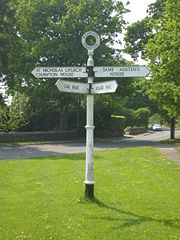
Fingerpost
A fingerpost is a name given to traditional British and Irish sign posts comprising a post with one or more arms — known as fingers — pointing in the direction of travel to named places on the fingers...
signs for routes suitable for local traffic only. These routes, it publicises in leaflets and other media.
For ease of reference, the main colour coding rules are summarised in Table 1.
| Background | Border | Lettering | Usage | Ruleset |
| White | Black | Black | Non-primary Route | Worboys |
| White | Red | Black | Ministry of Defence Ministry of Defence (United Kingdom) The Ministry of Defence is the United Kingdom government department responsible for implementation of government defence policy and is the headquarters of the British Armed Forces.... sites |
|
| Yellow | Black | Black | Roadworks | Guildford |
| Green | White | White with Yellow Route Numbers | Primary Route | Worboys |
| Blue | White | White | Motorway | Anderson |
| Brown | White | White | Attractions | |
Table 1
The colour coding for Patches and/or Panels on signs is summarised in Table 2.
| Patch or Panel Border | Lettering | Usage | Ruleset |
| Red | White | Hospitals | Guildford |
| Red | Black | Ministry of Defence sites | Guildford |
| Green | White | Primary Route | Guildford |
| Blue | White | Motorway | Guildford |
| Brown | White | Attractions | Guildford |
Table 2
Typefaces
Two typefaceTypeface
In typography, a typeface is the artistic representation or interpretation of characters; it is the way the type looks. Each type is designed and there are thousands of different typefaces in existence, with new ones being developed constantly....
s are specified for current British road signs: Transport
Transport (typeface)
Transport is a sans serif typeface designed for road signs in the United Kingdom. It was created between 1957 and 1963 by Jock Kinneir and Margaret Calvert as part of their work as designers for the Department of Transport's Anderson and Worboys committees....
and Motorway
Motorway (typeface)
Motorway is a typeface designed by Jock Kinneir and Margaret Calvert for use on the motorway network of the United Kingdom. It was first used on the M6 Preston bypass in 1958 and has been in use on the UK's motorways since...
.
Transport is a mixed-case font and is used for all text on fixed permanent signs except route numbers on motorway signs. It is used in two weights: Transport Medium (for light text on dark backgrounds) and Transport Heavy (for dark text on light backgrounds).
Motorway has a limited character set consisting of just numbers and a few letters and symbols needed to show route numbers; it has elongated characters and is designed to add emphasis to route numbers on motorways. Motorway is used to sign all route numbers on motorways themselves, and may also be used on non-motorway roads to sign directions in which motorway regulations apply immediately (such as motorway slip roads).
Motorway Permanent is light characters on dark background; Motorway Temporary (dark on light).
Transport Medium and Motorway Permanent were developed for the Anderson Committee and appeared on the first motorway signs. The other two typefaces are similar but have additional stroke width in the letters to compensate for light backgrounds. These typefaces are the only ones permitted on road signs in the UK. Although signs containing other typefaces do appear occasionally in some places, they are explicitly forbidden in Government guidelines, and are technically illegal.
Language

Wales
Wales is a country that is part of the United Kingdom and the island of Great Britain, bordered by England to its east and the Atlantic Ocean and Irish Sea to its west. It has a population of three million, and a total area of 20,779 km²...
. Welsh highway authorities choose whether they are "English-priority" or "Welsh-priority", and the language having priority in each highway authority's area appears first on signs. Most of south Wales is English-priority while western, mid, and most of northern Wales are Welsh-priority. Bilingual signs were permitted by special authorisation after 1965 and in 1972 the Bowen Committee recommended that they should be provided systematically throughout Wales.
Bilingual signing in Wales and elsewhere has caused traffic engineers to inquire into the safety ramifications of providing sign legend in multiple languages. As a result some countries have opted to limit bilingual signing to dual-name signs near places of cultural importance (New Zealand
New Zealand
New Zealand is an island country in the south-western Pacific Ocean comprising two main landmasses and numerous smaller islands. The country is situated some east of Australia across the Tasman Sea, and roughly south of the Pacific island nations of New Caledonia, Fiji, and Tonga...
), or to use it only in narrowly circumscribed areas such as near borders or in designated language zones (such as the North American Free Trade Agreement
North American Free Trade Agreement
The North American Free Trade Agreement or NAFTA is an agreement signed by the governments of Canada, Mexico, and the United States, creating a trilateral trade bloc in North America. The agreement came into force on January 1, 1994. It superseded the Canada – United States Free Trade Agreement...
(NAFTA) countries). A small number of these signs exist in the UK on major roads that leave major ports (such as Dover
Dover
Dover is a town and major ferry port in the home county of Kent, in South East England. It faces France across the narrowest part of the English Channel, and lies south-east of Canterbury; east of Kent's administrative capital Maidstone; and north-east along the coastline from Dungeness and Hastings...
). They detail in English, French
French language
French is a Romance language spoken as a first language in France, the Romandy region in Switzerland, Wallonia and Brussels in Belgium, Monaco, the regions of Quebec and Acadia in Canada, and by various communities elsewhere. Second-language speakers of French are distributed throughout many parts...
, German
German language
German is a West Germanic language, related to and classified alongside English and Dutch. With an estimated 90 – 98 million native speakers, German is one of the world's major languages and is the most widely-spoken first language in the European Union....
, and, occasionally, Swedish
Swedish language
Swedish is a North Germanic language, spoken by approximately 10 million people, predominantly in Sweden and parts of Finland, especially along its coast and on the Åland islands. It is largely mutually intelligible with Norwegian and Danish...
, standard speed limits and reminders to drive on the left. Multi-lingual "no parking" signs exist in several locations on the M25
M25 motorway
The M25 motorway, or London Orbital, is a orbital motorway that almost encircles Greater London, England, in the United Kingdom. The motorway was first mooted early in the 20th century. A few sections, based on the now abandoned London Ringways plan, were constructed in the early 1970s and it ...
.
In the Scottish Highlands
Scottish Highlands
The Highlands is an historic region of Scotland. The area is sometimes referred to as the "Scottish Highlands". It was culturally distinguishable from the Lowlands from the later Middle Ages into the modern period, when Lowland Scots replaced Scottish Gaelic throughout most of the Lowlands...
, road signs often have Scottish Gaelic in green, in addition to English in black. This seems to be part of the Gaelic language revival encouraged by many, including the Bòrd na Gàidhlig
Bòrd na Gàidhlig
Bòrd na Gàidhlig is a quango appointed by the Scottish Government with responsibility for Scottish Gaelic...
; see Gaelic road signs in Scotland
Gaelic road signs in Scotland
In the Gaelic-speaking parts of Scotland, the use of the Gaelic language on road signs instead of, or more often alongside, English is now common, but has historically been a controversial issue of symbolic rather than practical significance for people on both sides of the debate.- History :In the...
.
Retroreflection
Road signs in the UK must be retroreflective in order for drivers to read them at night. There are 3 commonly used grades of materials used:Class 1 (Engineering Grade)is a low performance glass bead product, it was the first reflective material used on the UK network and invented by 3M. Today in the UK it is used only for street nameplates and parking signs.
Class 2 (High Intensity) is generally a microprismatic product which uses truncated cube corners to return light to the driver. It is commonly used for directional signs or less important regulatory signs. There are also high intensity glass bead products that meet this class.
Class 3 (Diamond Grade)is a high end microprismatic product for important signs, those on high speed roads and in areas of ambient lighting where a driver may be distracted by the light clutter. Class 3 can be divided into two divisions; 3A for long distance and 3B for short distance. Currently the only product that performs to these levels is DG3.
Directional signs
An Advance Direction Sign may be one of four types:
- Stack type — with the destinations in each direction on a separate panel that also contains an arrow;
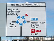
- Map-type — to give a highly clear and simplified diagrammatic plan view of a junction, for example a roundaboutRoundaboutA roundabout is the name for a road junction in which traffic moves in one direction around a central island. The word dates from the early 20th century. Roundabouts are common in many countries around the world...
. - Dedicated lane — shows the destinations separated by vertical dotted lines to indicate which lane to use;
- Mounted overhead — for use on busy motorways and other wide roads where verge mounted signs would be frequently obstructed by other traffic.
An ADS generally has blue, green or white as its background colour to indicate the status of road (motorway, primary or non-primary) on which it is placed. Except on the main carriageway of a motorway, coloured panels are used to indicate routes from the junction being signed that have a different status. A DS should always be a single colour indicating the status of the road to be joined, although there are a few rare exceptions to this rule.
The Heavy and Medium typefaces were designed to compensate for the optical illusion that makes dark lines on pale backgrounds appear narrower than pale lines on dark backgrounds. Hence destinations are written in mixed case white Transport Medium on green and blue backgrounds, and in black Transport Heavy on white backgrounds. Route numbers are coloured yellow when placed directly on a green background. Some signs logically show the closest destination on the route first (ie, on top), while others show the most distant settlement first. On a roundabout DS, the route locations are usually listed with the closest destination at the bottom and the furthest away at the top when going straight ahead, and likewise going left and right. However, many left-right signs logically indicate the closest destination at the top with further afield destinations listed in descending order.
Destinations/roads which cannot be directly accessed on a driver's current actual route, but can be accessed via an artery route of that carriageway, are displayed in brackets.
All types of ADS (but not DS) may optionally have the junction name at the top of the sign in capital letters in a separate panel.
A route confirmatory sign is placed either after a junction where distances were not shown on the ADS or DS or is placed on an overhead information sign but does not show distances to the destinations along that route.
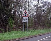
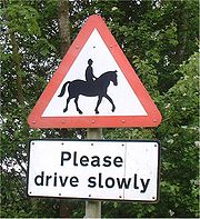
Warning signs
The importance of a warning signWarning sign
A traffic warning sign is a type of traffic sign that indicates a hazard ahead on the road that may not be readily apparent to a driver.In most countries, they usually take the shape of an equilateral triangle with a white background and a thick red border...
is emphasised by the red border drawn around it and the mostly triangular shape.
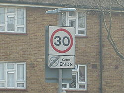
Regulatory signs
Signs in circular red borders are prohibitive, whether or not they also have a diagonal red line. Circular blue signs mainly give a positive (mandatory) instruction. Such circular signs may be accompanied by, or place on, a rectangular plate (information) that provides details of the prohibition or instruction; for example, waiting and loading plates and zone entry signs."Stop" signs (octagonal) and "Give Way" signs (inverted triangle) are the two notable exceptions, the distinctive shapes being recognisable even if the face is obscured by dirt or snow.
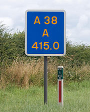
Informational signs
Informational signs are mainly rectangular (square or oblong) but, strictly speaking, this category also covers directional signs. They are often coloured to match the directional signing for the status of road in question, but where this is not necessary they are generally blue with white text. Examples include "lane gain" and "lane drop" signs on grade-separatedGrade separation
Grade separation is the method of aligning a junction of two or more transport axes at different heights so that they will not disrupt the traffic flow on other transit routes when they cross each other. The composition of such transport axes does not have to be uniform; it can consist of a...
roads, and "IN" and "OUT" indications for accesses to private premises from the highway.
Road works signs
Road works are normally signalled with a triangular, red-bordered warning format is used to indicate that there are works ahead. The graphic is of a man digging. Within the roadworks, diversions and other instructions to drivers are normally given on yellow signs with black script.Street name signs
Legally these are not defined as traffic signs in the UK. This gives authorities flexibility on the design and placement of them. They can be fixed to a signpost, wall, lamp column, or building. The text is usually in the Transport typeface used on road signs. It is also common for street nameplates to use the serifSerif
In typography, serifs are semi-structural details on the ends of some of the strokes that make up letters and symbols. A typeface with serifs is called a serif typeface . A typeface without serifs is called sans serif or sans-serif, from the French sans, meaning “without”...
font designed by David Kindersley
David Kindersley
David Guy Barnabas Kindersley was a British stone letter-carver and typeface designer, and the founder of the Kindersley Workshop . His carved plaques and inscriptions in stone and slate can be seen on many churches and public buildings in the United Kingdom...
.
Location identifiers
Numbered route markersHighway route markers
Highway route markers are the modern-day equivalent of milestones. Unlike traditional milestones, however, which were originally carved from stone and sited at one-mile intervals, modern highway route markers are made from a variety of materials and are almost invariably spaced at intervals of a...
of one type or another are used to identify specific locations along a road. Historically, milestone
Milestone
A milestone is one of a series of numbered markers placed along a road or boundary at intervals of one mile or occasionally, parts of a mile. They are typically located at the side of the road or in a median. They are alternatively known as mile markers, mileposts or mile posts...
s were used, but since the early 20th century they fell into disuse. However, for administrative and maintenance purposes, distance marker posts and driver location signs
Driver location signs
Driver location signs are English highway route markers, first introduced in 2003, that complement distance marker posts. Both types of marker post display the distances from a nominal start point in kilometres...
have been erected on motorways and certain dual carriageways.
The numbers on distance marker posts are embedded into emergency roadside telephone numbers and are used by the emergency services to pinpoint incidents.
The advent of the mobile phone meant that location information embedded into motorway emergency telephone systems was not being accessed by drivers and since 2007 driver location signs have been erected on many motorways. These contain important information about the location and carriageway direction, and the reference number should be quoted in full when contacting the emergency services.
Northern Ireland, Crown Dependencies and overseas territories
The designs of road signs in Great BritainGreat Britain
Great Britain or Britain is an island situated to the northwest of Continental Europe. It is the ninth largest island in the world, and the largest European island, as well as the largest of the British Isles...
is prescribed in the Traffic Signs Regulations and General Directions (TSRGD) apply specifically to England, Scotland and Wales. These regulations do not extend to other territories that come under the jurisdiction of the Crown
The Crown
The Crown is a corporation sole that in the Commonwealth realms and any provincial or state sub-divisions thereof represents the legal embodiment of governance, whether executive, legislative, or judicial...
. Road signs in Northern Ireland
Northern Ireland
Northern Ireland is one of the four countries of the United Kingdom. Situated in the north-east of the island of Ireland, it shares a border with the Republic of Ireland to the south and west...
, the Channel Islands
Channel Islands
The Channel Islands are an archipelago of British Crown Dependencies in the English Channel, off the French coast of Normandy. They include two separate bailiwicks: the Bailiwick of Guernsey and the Bailiwick of Jersey...
and the Isle of Man
Isle of Man
The Isle of Man , otherwise known simply as Mann , is a self-governing British Crown Dependency, located in the Irish Sea between the islands of Great Britain and Ireland, within the British Isles. The head of state is Queen Elizabeth II, who holds the title of Lord of Mann. The Lord of Mann is...
are under the jurisdiction of their local legislatures. Although the policy in these territories is to align their road signs with those prescribed in the TSRGD, small variations may be seen.
Traffic signs in Northern Ireland are prescribed by The Traffic Signs Regulations (Northern Ireland) 1997 and are administered by the Northern Ireland Assembly
Northern Ireland Assembly
The Northern Ireland Assembly is the devolved legislature of Northern Ireland. It has power to legislate in a wide range of areas that are not explicitly reserved to the Parliament of the United Kingdom, and to appoint the Northern Ireland Executive...
. The Tynwald
Tynwald
The Tynwald , or more formally, the High Court of Tynwald is the legislature of the Isle of Man. It is claimed to be the oldest continuous parliamentary body in the world, consisting of the directly elected House of Keys and the indirectly chosen Legislative Council.The Houses sit jointly, for...
(Isle of Man Parliament), through its Traffic Signs (Application) Regulations 2003 explicitly included Part I of the TSRGD into Manx law, but not the other parts of that legislation. One of the consequences of this partial incorporation is that while in England and Wales speed limit signs must appear on both sides of a carriageway, this is not necessary in the Isle of Man.
Road signs in Gibraltar
Gibraltar
Gibraltar is a British overseas territory located on the southern end of the Iberian Peninsula at the entrance of the Mediterranean. A peninsula with an area of , it has a northern border with Andalusia, Spain. The Rock of Gibraltar is the major landmark of the region...
and the British Sovereign Base Areas
Sovereign Base Areas
The Sovereign Base Areas are military bases located on territory in which the United Kingdom is sovereign, but which are separated from the ordinary British territory....
in Cyprus are controlled by the Ministry of Defence. In the SBA road signs are modelled on Cypriot road signs rather than British Road signs including the use of metric speed limits while in Gibraltar the rule of the road is to drive on the right and to use metric units (as in the rest of the Iberian peninsula).
Road signs in Hong Kong also use a modified version of the British model, including the Transport font. This policy has continued post- the 1997 transfer of sovereignty to China. Directional signs include place-names in Chinese characters which have been designed to match the Transport font, as well as English-language text.
See also
- Highway CodeHighway CodeThe Highway Code is the official road user guide for Great Britain. In Northern Ireland the applies while the Republic of Ireland has its own Rules of the Road. It contains 306 numbered rules and 9 annexes covering pedestrians, animals, cyclists, motorcyclists and drivers...
- Gaelic road signs in ScotlandGaelic road signs in ScotlandIn the Gaelic-speaking parts of Scotland, the use of the Gaelic language on road signs instead of, or more often alongside, English is now common, but has historically been a controversial issue of symbolic rather than practical significance for people on both sides of the debate.- History :In the...
- Road signs in WalesRoad signs in WalesRoad signs in Wales follow the same design principles as those in other parts of the United Kingdom. However, all modern road signs feature directions in both the Welsh and English languages, with the Welsh first in many principal areas.-Current policy:...
- Off-Network Tactical Diversion RouteOff-Network Tactical Diversion RouteIn the United Kingdom, Emergency Diversion Routes are planned road traffic routes that bypass the main trunk road network.Emergency Diversion routes provide the public with a pre-planned, checked and agreed junction to junction diversion route that circumnavigates an incident which has resulted in...
- FingerpostFingerpostA fingerpost is a name given to traditional British and Irish sign posts comprising a post with one or more arms — known as fingers — pointing in the direction of travel to named places on the fingers...
- SignageSignageSignage is any kind of visual graphics created to display information to a particular audience. This is typically manifested in the form of wayfinding information in places such as streets or inside/outside of buildings.-History:...
External links
Official government websites- Department for Transport traffic signs and signals index page
- The Traffic Signs Regulations and General Directions 2002
- Know Your Traffic Signs, DfT 2007 (PDF 6MB)
- Signs & Markings. Part of the Highway Code website
Driving test websites
History
Other resources