

Geology of British Columbia
Encyclopedia
British Columbia
British Columbia is the westernmost of Canada's provinces and is known for its natural beauty, as reflected in its Latin motto, Splendor sine occasu . Its name was chosen by Queen Victoria in 1858...
is a function of its location on the leading edge of the North American continent
North America
North America is a continent wholly within the Northern Hemisphere and almost wholly within the Western Hemisphere. It is also considered a northern subcontinent of the Americas...
. The mountainous physiography and the diversity of rock types and ages hint at the complex geology
Geology
Geology is the science comprising the study of solid Earth, the rocks of which it is composed, and the processes by which it evolves. Geology gives insight into the history of the Earth, as it provides the primary evidence for plate tectonics, the evolutionary history of life, and past climates...
, which is still undergoing revision despite a century of exploration and mapping.
The country's most prominent geological features are mountain range
Mountain range
A mountain range is a single, large mass consisting of a succession of mountains or narrowly spaced mountain ridges, with or without peaks, closely related in position, direction, formation, and age; a component part of a mountain system or of a mountain chain...
s, including the North American Cordillera
North American Cordillera
The North American Cordillera is the North American portion of the American Cordillera which is a cordillera extending up and down the western side of the Americas. The North American Cordillera covers an extensive area of mountain ranges, intermontane basins, and plateaus in western North...
, which stretches from Southern Mexico
Mexico
The United Mexican States , commonly known as Mexico , is a federal constitutional republic in North America. It is bordered on the north by the United States; on the south and west by the Pacific Ocean; on the southeast by Guatemala, Belize, and the Caribbean Sea; and on the east by the Gulf of...
to Alaska
Alaska
Alaska is the largest state in the United States by area. It is situated in the northwest extremity of the North American continent, with Canada to the east, the Arctic Ocean to the north, and the Pacific Ocean to the west and south, with Russia further west across the Bering Strait...
.
Terrane theory
TerraneTerrane
A terrane in geology is short-hand term for a tectonostratigraphic terrane, which is a fragment of crustal material formed on, or broken off from, one tectonic plate and accreted or "sutured" to crust lying on another plate...
theory was first proposed by Jim Monger of the Geological Survey of Canada and Charlie Rouse in 1971 as an explanation for a set of fusilinid fossils found in central British Columbia. Rather than use facies
Facies
In geology, facies are a body of rock with specified characteristics. Ideally, a facies is a distinctive rock unit that forms under certain conditions of sedimentation, reflecting a particular process or environment....
changes or seaway
Seaway
Seaway is a Canadian drama series that aired on CBC from 1965 to 1966. The series was a Seaway Films production in collaboration with the UK's ATV, with production money provided by the CBC...
s (which were common explanations at the time), the two geologists proposed that the fossils in question had been part of an assemblage of rocks that had migrated across the Pacific Ocean
Pacific Ocean
The Pacific Ocean is the largest of the Earth's oceanic divisions. It extends from the Arctic in the north to the Southern Ocean in the south, bounded by Asia and Australia in the west, and the Americas in the east.At 165.2 million square kilometres in area, this largest division of the World...
to their present location. This theory was then developed by Porter Irwin and Davy Jones of the US Geological Survey to its common definition of "fault bounded regional geologic entities, each characterized by a different geologic history than its neighbours".
Terranes are most commonly associated with different tectonic elements such as island arcs, volcanic plateau
Volcanic plateau
A volcanic plateau is a plateau produced by volcanic activity. There are two main types: lava plateaus and pyroclastic plateaus.-Lava plateau:...
s, subduction zones, continental margin
Continental margin
The continental margin is the zone of the ocean floor that separates the thin oceanic crust from thick continental crust. Continental margins constitute about 28% of the oceanic area....
s, mid-oceanic ridges and continental fragment
Continental fragment
Continental crustal fragments, partially synonymous with microcontinents, are fragments of continents thought to have been broken off from the main continental mass forming distinct islands, possibly several hundred kilometers from their place of origin...
s. These terranes are gradually joined together by elements such as overlap assemblages and stitching plutons and are then accreted
Accretion (geology)
Accretion is a process by which material is added to a tectonic plate or a landmass. This material may be sediment, volcanic arcs, seamounts or other igneous features.-Description:...
to the continent. In some cases, a terrane can contain multiple tectonic elements. The Cache Creek Terrane
Cache Creek Terrane
The Cache Creek Terrane is a geologic terrane in British Columbia and southern Yukon, Canada. It consists of volcanics, carbonate rocks, coarse clastic rocks and small amounts of ultramafic rock, chert and argillite....
is composed of a massive carbonate
Carbonate rock
Carbonate rocks are a class of sedimentary rocks composed primarily of carbonate minerals. The two major types are limestone, which is composed of calcite or aragonite and dolostone, which is composed of the mineral dolomite .Calcite can be either dissolved by groundwater or precipitated by...
component, an oceanic floor
Oceanic crust
Oceanic crust is the part of Earth's lithosphere that surfaces in the ocean basins. Oceanic crust is primarily composed of mafic rocks, or sima, which is rich in iron and magnesium...
component and a subduction
Subduction
In geology, subduction is the process that takes place at convergent boundaries by which one tectonic plate moves under another tectonic plate, sinking into the Earth's mantle, as the plates converge. These 3D regions of mantle downwellings are known as "Subduction Zones"...
mélange
Mélange
In geology, a mélange is a large-scale breccia, a mappable body of rock characterized by a lack of continuous bedding and the inclusion of fragments of rock of all sizes, contained in a fine-grained deformed matrix. The mélange typically consists of a jumble of large blocks of varied lithologies...
component.
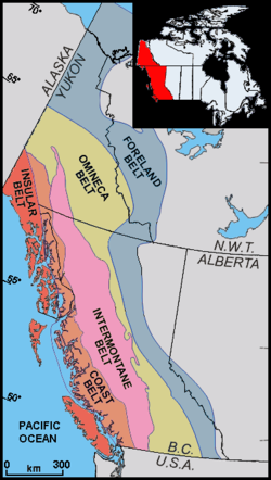
Architecture and composition
There are five morpho-geological belts that define the geology of British Columbia from east to west: the Foreland, Omineca, Intermontane, Coast and Insular Belt. Each has a separate geology, including different metamorphic, physiograhpic, metallogenic and tectonic histories.The Foreland Belt is composed of weakly metamorphosed sedimentary rocks which are 1.4 billion to 33 million years olds, and the belt represents a rift
Rift
In geology, a rift or chasm is a place where the Earth's crust and lithosphere are being pulled apart and is an example of extensional tectonics....
sequence followed by a passive margin
Passive margin
A passive margin is the transition between oceanic and continental crust which is not an active plate margin. It is constructed by sedimentation above an ancient rift, now marked by transitional crust. Continental rifting creates new ocean basins. Eventually the continental rift forms a mid-oceanic...
that was turned into a retro arc fold and thrust belt with synorogenic sedimentation. The region is very rugged except in the northeast of the province where the earth flattens out to a wide plain.
The Omineca Belt is composed of highly metamorphosed, pericratonic (near craton) terranes and fragments of North America that are 2 billion to 180 million years old. Terranes in the belt include the Slide Mountain Terrane
Slide Mountain Terrane
The Slide Mountain Terrane is a late Paleozoic terrane made of a complex of oceanic rocks in northern and southern British Columbia, Canada. These oceanic rocks were derived from the seafloor of the prehistoric Slide Mountain Ocean, the Intermontane Plate, which was subducted under the North...
, the Yukon-Tanana Terrane
Yukon-Tanana Terrane
The Yukon-Tanana Terrane is a tectonic terrane that extends from central Alaska through central Yukon and into northern British Columbia, Canada and Southeast Alaska, USA. Extending over 2000 km, the YTT is the largest tectonostratigraphic terrane in the northern North American Cordillera...
and the Cassiar Terrane
Cassiar Terrane
The Cassiar Terrane is a long Cretaceous terrane located in the Northern Interior British Columbia and southern Yukon. It consists of miogeoclinal strata and contains the Cassiar Batholith, a 100 million year old igneous intrusion and the single largest intrusive body in the hinterland of the...
. This belt goes from low hills to high mountains across its length, with the majority of the region being extremely rugged.
The Intermontane Belt
Intermontane Belt
The Intermontane Belt is a physiogeological region in the Pacific Northwest of North America, stretching from northern Washington into British Columbia, Yukon, and Alaska. It comprises rolling hills, high plateaus and deeply cut valleys. The rocks in the belt have very little similarities with the...
is a flatter, more rounded region composed of three terranes, Stikinia
Stikinia
Stikinia is the name of a tectonostratigraphic terrane in the Canadian Cordillera of British Columbia, Canada. It was formed in a volcanic arc environment during the Paleozoic and Mesozoic periods...
, Quenellia and the Cache Creek Terrane. The belt has a lower metamorphic grade than the Omineca Belt and ranges from 400 million to within 10,000 years old. Volcanic activity has been recorded as occurring in the past 10,000 years, including at Nazko Cone
Nazko Cone
Nazko Cone is a small potentially active basaltic cinder cone in central British Columbia, Canada, located 75 km west of Quesnel and 150 kilometers southwest of Prince George. It is considered the easternmost volcano in the Anahim Volcanic Belt. The small tree-covered cone rises 120 m above...
and in the Satah Mountain volcanic field
Satah Mountain volcanic field
The Satah Mountain volcanic field is an extensive north-south trending volcanic chain in the Central Interior of British Columbia that stretches south of the Itcha Range shield volcano to northeast of Nimpo Lake. The chain is located on the Chilcotin Plateau, a major subdivision of the Interior...
.
The Coast Belt is the single largest outpouring of granite and granodiorite in the phanerozoic, it contains heavily metamorphosed fragments of both the terranes of the Insular Belt
Insular Belt
The Insular Belt is a physiogeological region on the north western North American coast. It consist of three major island groups and many smaller islands and stretches from southern British Columbia into Alaska and the Yukon...
and the Intermontane Belt. In the southeast there is a series of small terranes of both oceanic (Bridge River and Chilliwack) and continental affinity (Jack Konat Mountain, Ladner). The hard weathering granite is extensively rugged the throughout the belt.
The Insular Belt is composed of the outboard terrain with no connection to North America before accretion. There are two main terranes—Wrangellia and the Alexander—and few smaller ones such as the Leech River and Crescent terranes. Because the Insular Belt is the most tectonically active of the belts, it has the greatest relief differences from the depths of Queen Charlotte sound to the heights of the Wrangell–St. Elias mountains. The ages are from 600 million years to recent, with metamorphic grade depending on the age and host of the rock type.
See also
- Coast MountainsCoast MountainsThe Coast Mountains are a major mountain range, in the Pacific Coast Ranges, of western North America, extending from southwestern Yukon through the Alaska Panhandle and virtually all of the Coast of British Columbia. They are so-named because of their proximity to the sea coast, and are often...
- Coast Range ArcCoast Range ArcThe Coast Range Arc was a large volcanic arc system, extending from northern Washington through British Columbia and the Alaska Panhandle to southwestern Yukon. The Coast Range Arc lies along the western margin of the North American Plate in the Pacific Northwest of western North America...
- Okanagan HighlandOkanagan HighlandThe Okanagan Highland is a plateau-like hilly area in British Columbia, Canada, and the U.S. state of Washington . It lies between the Okanagan Valley on its west and the Kettle River on its east, and geologically is more or less an extension of the Thompson Plateau, which lies west of the Okanagan...
- Omineca MountainsOmineca MountainsThe Omineca Mountains, also known as "the Ominecas", are a group of remote mountain ranges in north-central British Columbia, Canada. They are bounded by the Finlay River on the north, the Rocky Mountain Trench on the east, the Nation River on the south, and the upper reaches of the Omineca River...
- Quesnel HighlandQuesnel HighlandThe Quesnel Highland is a geographic area in the Central Interior of the Canadian province of British Columbia. As defined by BC government geographer in Landforms of British Columbia, an account and analysis of British Columbia geography that is often cited as authoritative...
- Shuswap HighlandShuswap HighlandThe Shuswap Highland is a plateau-like hilly area of in British Columbia, Canada. It spans the upland area between the Bonaparte and Thompson Plateaus from the area of Mahood Lake, at the southeast corner of the Cariboo Plateau, southeast towards the lower Shuswap River east of Vernon in the...
- Geology of the Pacific NorthwestGeology of the Pacific NorthwestThe geology of the Pacific Northwest refers to the study of the composition , structure, physical properties and the processes that shape the Pacific Northwest region of the United States and Canada...
- Volcanism of Canada
- Pacific Ring of FirePacific Ring of FireThe Pacific Ring of Fire is an area where large numbers of earthquakes and volcanic eruptions occur in the basin of the Pacific Ocean. In a horseshoe shape, it is associated with a nearly continuous series of oceanic trenches, volcanic arcs, and volcanic belts and/or plate movements...
External links
- Government of British Columbia: Geology of BC
- Evolution of the Pacific Northwest Good text on the geology of Cascadia.