
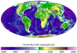
Terrain
Encyclopedia
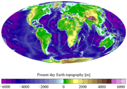
.jpg)
Underwater
Underwater is a term describing the realm below the surface of water where the water exists in a natural feature such as an ocean, sea, lake, pond, or river. Three quarters of the planet Earth is covered by water...
, the term bathymetry
Bathymetry
Bathymetry is the study of underwater depth of lake or ocean floors. In other words, bathymetry is the underwater equivalent to hypsometry. The name comes from Greek βαθύς , "deep", and μέτρον , "measure"...
is used. In America, topography
Topography
Topography is the study of Earth's surface shape and features or those ofplanets, moons, and asteroids...
has recently become an additional synonym, though in many parts of the world it retains its original more general meaning of description of place.
Terrain is used as a general term in physical geography
Physical geography
Physical geography is one of the two major subfields of geography. Physical geography is that branch of natural science which deals with the study of processes and patterns in the natural environment like the atmosphere, biosphere and geosphere, as opposed to the cultural or built environment, the...
, referring to the lie of the land. This is usually expressed in terms of the elevation
Elevation
The elevation of a geographic location is its height above a fixed reference point, most commonly a reference geoid, a mathematical model of the Earth's sea level as an equipotential gravitational surface ....
, slope
Slope
In mathematics, the slope or gradient of a line describes its steepness, incline, or grade. A higher slope value indicates a steeper incline....
, and orientation of terrain features. Terrain affects surface water flow and distribution. Over a large area, it can affect weather
Weather
Weather is the state of the atmosphere, to the degree that it is hot or cold, wet or dry, calm or stormy, clear or cloudy. Most weather phenomena occur in the troposphere, just below the stratosphere. Weather refers, generally, to day-to-day temperature and precipitation activity, whereas climate...
and climate
Climate
Climate encompasses the statistics of temperature, humidity, atmospheric pressure, wind, rainfall, atmospheric particle count and other meteorological elemental measurements in a given region over long periods...
patterns.
Importance
The understanding of terrain is critical for many reasons:- The terrain of a region largely determines its suitability for human settlement: flatter, alluvial plains tend to have better farming soils than steeper, rockier uplands.
- In terms of environmentalNatural environmentThe natural environment encompasses all living and non-living things occurring naturally on Earth or some region thereof. It is an environment that encompasses the interaction of all living species....
quality, agricultureAgricultureAgriculture is the cultivation of animals, plants, fungi and other life forms for food, fiber, and other products used to sustain life. Agriculture was the key implement in the rise of sedentary human civilization, whereby farming of domesticated species created food surpluses that nurtured the...
, and hydrologyHydrologyHydrology is the study of the movement, distribution, and quality of water on Earth and other planets, including the hydrologic cycle, water resources and environmental watershed sustainability...
, understanding the terrain of an area enables the understanding of watershedDrainage basinA drainage basin is an extent or an area of land where surface water from rain and melting snow or ice converges to a single point, usually the exit of the basin, where the waters join another waterbody, such as a river, lake, reservoir, estuary, wetland, sea, or ocean...
boundaries, drainageDrainageDrainage is the natural or artificial removal of surface and sub-surface water from an area. Many agricultural soils need drainage to improve production or to manage water supplies.-Early history:...
characteristics, waterWaterWater is a chemical substance with the chemical formula H2O. A water molecule contains one oxygen and two hydrogen atoms connected by covalent bonds. Water is a liquid at ambient conditions, but it often co-exists on Earth with its solid state, ice, and gaseous state . Water also exists in a...
movement, and impacts on water qualityWater qualityWater quality is the physical, chemical and biological characteristics of water. It is a measure of the condition of water relative to the requirements of one or more biotic species and or to any human need or purpose. It is most frequently used by reference to a set of standards against which...
. Complex arrays of relief data are used as input parameters for hydrology transport models (such as the SWMM or DSSAM ModelDSSAM ModelThe DSSAM Model is a computer simulation developed for the Truckee River to analyze water quality impacts from land use and wastewater management decisions in the Truckee River Basin. This area includes the cities of Reno and Sparks, Nevada as well as the Lake Tahoe Basin...
s) to allow prediction of river water qualityWater pollutionWater pollution is the contamination of water bodies . Water pollution occurs when pollutants are discharged directly or indirectly into water bodies without adequate treatment to remove harmful compounds....
. - Understanding terrain also supports on soil conservationSoil conservationSoil conservation is a set of management strategies for prevention of soil being eroded from the Earth’s surface or becoming chemically altered by overuse, acidification, salinization or other chemical soil contamination...
, especially in agriculture. ContourContour lineA contour line of a function of two variables is a curve along which the function has a constant value. In cartography, a contour line joins points of equal elevation above a given level, such as mean sea level...
plowingPloughThe plough or plow is a tool used in farming for initial cultivation of soil in preparation for sowing seed or planting. It has been a basic instrument for most of recorded history, and represents one of the major advances in agriculture...
is an established practice enabling sustainable agricultureSustainable agricultureSustainable agriculture is the practice of farming using principles of ecology, the study of relationships between organisms and their environment...
on sloping land; it is the practice of plowing along lines of equal elevation instead of up and down a slope. - Terrain is militarilyMilitaryA military is an organization authorized by its greater society to use lethal force, usually including use of weapons, in defending its country by combating actual or perceived threats. The military may have additional functions of use to its greater society, such as advancing a political agenda e.g...
critical because it determines the ability of armed forcesArmed forcesThe armed forces of a country are its government-sponsored defense, fighting forces, and organizations. They exist to further the foreign and domestic policies of their governing body, and to defend that body and the nation it represents from external aggressors. In some countries paramilitary...
to take and hold areas, and move troopTroopA troop is a military unit, originally a small force of cavalry, subordinate to a squadron and headed by the troop leader. In many armies a troop is the equivalent unit to the infantry section or platoon...
s and material into and through areas. An understanding of terrain is basic to both defensive and offensive strategy. - Terrain is important in determining weatherWeatherWeather is the state of the atmosphere, to the degree that it is hot or cold, wet or dry, calm or stormy, clear or cloudy. Most weather phenomena occur in the troposphere, just below the stratosphere. Weather refers, generally, to day-to-day temperature and precipitation activity, whereas climate...
patterns. Two areas geographically close to each other may differ radically in precipitationPrecipitation (meteorology)In meteorology, precipitation In meteorology, precipitation In meteorology, precipitation (also known as one of the classes of hydrometeors, which are atmospheric water phenomena is any product of the condensation of atmospheric water vapor that falls under gravity. The main forms of precipitation...
levels or timing because of elevation differences or a "rain shadowRain shadowA rain shadow is a dry area on the lee side of a mountainous area. The mountains block the passage of rain-producing weather systems, casting a "shadow" of dryness behind them. As shown by the diagram to the right, the warm moist air is "pulled" by the prevailing winds over a mountain...
" effect. - Precise knowledge of terrain is vital in aviationAviationAviation is the design, development, production, operation, and use of aircraft, especially heavier-than-air aircraft. Aviation is derived from avis, the Latin word for bird.-History:...
, especially for low-flying routes and maneuvers (see terrain collision avoidanceTerrain awareness and warning systemA terrain awareness and warning system aims to prevent "Controlled Flight Into Terrain" accidents. The actual systems in current use are known as ground proximity warning system and enhanced GPWS. The U.S. Federal Aviation Administration developed the TAWS term to encompass all current and...
) and airport altitudes. Terrain will also affect range and performance of radars and terrestrial radio navigation systems. Furthermore, a hilly or mountainous terrain may strongly impact the implementation of a new aerodromeAerodromeAn aerodrome, airdrome or airfield is a term for any location from which aircraft flight operations take place, regardless of whether they involve cargo, passengers or neither...
and the orientation of its runways.
Geomorphology
GeomorphologyGeomorphology
Geomorphology is the scientific study of landforms and the processes that shape them...
is in large part the study of the formation of terrain or topography. Terrain is formed by intersecting processes:
- GeologicalGeologyGeology is the science comprising the study of solid Earth, the rocks of which it is composed, and the processes by which it evolves. Geology gives insight into the history of the Earth, as it provides the primary evidence for plate tectonics, the evolutionary history of life, and past climates...
processes: migration of tectonic plates, faulting and foldingFold (geology)The term fold is used in geology when one or a stack of originally flat and planar surfaces, such as sedimentary strata, are bent or curved as a result of permanent deformation. Synsedimentary folds are those due to slumping of sedimentary material before it is lithified. Folds in rocks vary in...
, volcanic eruptions, riverRiverA river is a natural watercourse, usually freshwater, flowing towards an ocean, a lake, a sea, or another river. In a few cases, a river simply flows into the ground or dries up completely before reaching another body of water. Small rivers may also be called by several other names, including...
s. - Erosional processes: water and wind erosionErosionErosion is when materials are removed from the surface and changed into something else. It only works by hydraulic actions and transport of solids in the natural environment, and leads to the deposition of these materials elsewhere...
, landslides. - Extraterrestrial: meteoriteMeteoriteA meteorite is a natural object originating in outer space that survives impact with the Earth's surface. Meteorites can be big or small. Most meteorites derive from small astronomical objects called meteoroids, but they are also sometimes produced by impacts of asteroids...
impacts.
Tectonic processes such as orogenies
Orogeny
Orogeny refers to forces and events leading to a severe structural deformation of the Earth's crust due to the engagement of tectonic plates. Response to such engagement results in the formation of long tracts of highly deformed rock called orogens or orogenic belts...
cause land to be elevated, and erosional or weathering
Weathering
Weathering is the breaking down of rocks, soils and minerals as well as artificial materials through contact with the Earth's atmosphere, biota and waters...
processes cause land to be worn away to lower elevations.
Land surface parameters are quantitative measures of various morphometric properties of a surface. The most common examples are used to derive slope
Slope
In mathematics, the slope or gradient of a line describes its steepness, incline, or grade. A higher slope value indicates a steeper incline....
or aspect
Aspect
Aspect may be:*Aspect , a feature that is linked to many parts of a program, but which is not necessarily the primary function of the program...
of a terrain or curvatures at each location. These measures can also be used to derive hydrological parameters
Hydrology
Hydrology is the study of the movement, distribution, and quality of water on Earth and other planets, including the hydrologic cycle, water resources and environmental watershed sustainability...
that reflect flow/erosion processes. Climatic
Climate
Climate encompasses the statistics of temperature, humidity, atmospheric pressure, wind, rainfall, atmospheric particle count and other meteorological elemental measurements in a given region over long periods...
parameters are based on the modelling of solar radiation or air flow.
Land surface objects, or landform
Landform
A landform or physical feature in the earth sciences and geology sub-fields, comprises a geomorphological unit, and is largely defined by its surface form and location in the landscape, as part of the terrain, and as such, is typically an element of topography...
s, are definite physical objects (lines, points, areas) that differ from the surrounding objects. The most typical examples arelines of watershed
Water divide
A drainage divide, water divide, divide or watershed is the line separating neighbouring drainage basins...
s, stream
Stream
A stream is a body of water with a current, confined within a bed and stream banks. Depending on its locale or certain characteristics, a stream may be referred to as a branch, brook, beck, burn, creek, "crick", gill , kill, lick, rill, river, syke, bayou, rivulet, streamage, wash, run or...
patterns, ridge
Ridge
A ridge is a geological feature consisting of a chain of mountains or hills that form a continuous elevated crest for some distance. Ridges are usually termed hills or mountains as well, depending on size. There are several main types of ridges:...
s, break-line
Fall line
A fall line is a geomorphologic unconformity between an upland region of relatively hard crystalline basement rock and a coastal plain of softer sedimentary rock. A fall line is typically prominent when crossed by a river, for there will often be rapids or waterfalls...
s, pool
Stream pool
A stream pool, in hydrology, is a stretch of a river or stream in which the water depth is above average and the water velocity is quite below average.-Formation:...
s or borders of specific landforms.
See also
- Relief ratioRelief ratioThe relief ratio is a number calculated to describe the Grade of a river or stream.The calculation is just the difference in elevation between the river's source and the river's confluence or mouth divided by the total length of the river or stream. This gives the average drop in elevation per...
- Cartographic relief depictionCartographic relief depictionTerrain or relief is an essential aspect of physical geography, and as such its portrayal presents a central problem in cartography, and more recently GIS and 3D Visualization....
(2D relief map) - Raised-relief mapRaised-relief mapA raised-relief map or terrain model is a three-dimensional representation, usually of terrain. When representing terrain, the elevation dimension is usually exaggerated by a factor between five and ten; this facilitates the visual recognition of terrain features.-History:In his 1665 paper for the...
(3D relief map) - Digital terrain model
- Geographic Information SystemGeographic Information SystemA geographic information system, geographical information science, or geospatial information studies is a system designed to capture, store, manipulate, analyze, manage, and present all types of geographically referenced data...
s (GIS) - Applications of global navigation satellite systems (GNSS)
- GeomorphometryGeomorphometryGeomorphometry is the science of quantitative land surface analysis. It gathers various mathematical, statistical and image processing techniques that can be used to quantify morphological, hydrological, ecological and other aspects of a land surface. Common synonyms for geomorphometry are...
- SubterraneaSubterranea (geography)Subterranea refers to underground structures, both natural and man-made . Some subterranea include:* Bunker* Casemate* Catacombs* Caves** Ice caves* Cave dwellings, Cave house* Cave temple* Cellar* Cenote* Dungeon...
- TerraneTerraneA terrane in geology is short-hand term for a tectonostratigraphic terrane, which is a fragment of crustal material formed on, or broken off from, one tectonic plate and accreted or "sutured" to crust lying on another plate...