
Fraser Valley
Encyclopedia
The Fraser Valley is the section of the Fraser River
basin in southwestern British Columbia
downstream of the Fraser Canyon
. The term is sometimes used to refer to the Fraser Canyon and stretches upstream from there, but in general British Columbian usage of the term refers to the stretch of the river downstream from the town of Hope
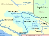
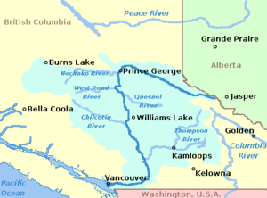
(about where the "r" in "Vancouver" is on the map below).
 After descending through the rapids of the Fraser Canyon
, the Fraser River emerges almost at sea level at Yale
, over 100 km inland. Although the canyon in geographic terms is defined at ending at Yale, Hope is generally to be considered the southern end of the canyon, partly because of the change in the character of the highway from that point , and perhaps also because it is at Hope that the first floodplain
s typifying the course of the Lower Fraser are found. Downstream from Hope, the river and adjoining floodplains widen considerably in the area of Rosedale
, Chilliwack
and Agassiz
, which is considered the head of the Fraser Delta. From there the river passes through some of the most fertile agricultural land in British Columbia—as well as the heart of the Metro Vancouver region—on its way through the valley to its mouth at Georgia Strait.
During the last ice age
, the area that would become the Fraser Valley was covered by a sheet of ice, walled in by the surrounding mountains. As the ice receded, land that had been covered by glaciers became covered by water instead, then slowly rose above the water, forming the basin that exists today. The valley is the largest landform
of the Lower Mainland
ecoregion, with its delta considered to begin in the area of Agassiz and Chilliwack, although stretches of floodplain flank the mountainsides between there and Hope.
Several of the Fraser's lower tributaries have floodplains of their own, shared in common with the Fraser freshet. Of varying size these include the Harrison River
, Chilliwack River (Vedder River
), Hatzic Creek and Hatzic Lake, the Stave
, Alouette
, Pitt
and Coquitlam River
s. Also incorporated in the Fraser delta region are the Nicomekl and Serpentine River floodplains and the Sumas River drainage, which flow to saltwater independently of the Fraser but help drain its lowland. The Fraser is tidal as far upstream as the town of Mission
and, across the river, the City of Abbotsford
, which is at the Fraser's closest approach to the international boundary, about 6 miles north of Sumas, Washington. Pitt Lake, one of the Fraser's last tributaries and among its largest, is so low in elevation, despite its mountain setting, that it is one of the largest tidal freshwater lakes in the world .
Oxbow lakes and side-sloughs are a common feature of the Lower Fraser's geography. The two main oxbows are those of Hatzic Lake and the Stave River on opposite sides of Mission, although that of the Stave has been silted in and part of it drained for a man-made lake. Around Fort Langley is an oxbow formation, mostly swamped in at the time of the fort's foundation, which was drained and made part of the fort's farm and remains farmland today. The system of sloughs and side-channels of the river is complicated, but important sloughs include those around Nicomen Island
, Sea Bird Island
and flanking the river from Rosedale
to Sumas Mountain
, on the western side of Chilliwack
.
, other than the Skwxwu7kmesh and Musqueam — was a vital lifeline before the first European contact
, and has been an important transportation corridor ever since.
In the nineteenth century, steamboat
s plied the waters between Georgia Strait and Yale, and were especially busy during the gold rush
from 1858 into the 1860s. Boats continued to provide a vital link in the valley as the gold rush tapered off and Europeans began farming.
Eventually, roads and railways were built, fueled by and in turn fuelling population growth. Today, the most important transportation l through the region are the Canadian Pacific Railway
and Canadian National Railway
transcontinental main lines, the Lougheed Highway (Hwy 7), and the Trans-Canada Highway
(Hwy 1).
, Surrey
, and Abbotsford
through golf courses and parks to dairy farms and market garden
s.
Agricultural land in the valley – much of it protected by the Agricultural Land Reserve
– is intensively farmed: the Fraser Valley brings in over half of British Columbia's annual agricultural revenue, although it makes up a small percentage of the province's total land area.
, acting as a natural outlet for the intensely cold Arctic air mass
which typically sits over Western Canada
during winter. Under certain meteorological conditions strong winds pour out of the Fraser Valley and over the relatively warmer waters of the Strait of Georgia
and the Strait of Juan de Fuca
. This can cause ocean-effect snow, especially between Port Angeles
and Sequim
, where the air mass collides with the Olympic Mountains
. The cold air from the Fraser Valley can also flow out over the Pacific Ocean. Lanes of convective ocean-effect clouds and showers are produced as heat and moisture modify the very dry, frigid air mass. These then typically organize as a low pressure system which returns the showers to the coast south of Canada, often bringing snow to unusually low elevations.
becomes an increasingly important issue; various controversies have risen over the years (most recently over "Sumas 2
", a defeated proposal for a power plant just south of the Canadian/USA border) as to whether or not air pollution is a problem, and if it is a problem, how this should be addressed.
Air quality monitoring has improved in recent years and it is now possible to compare BC communities on a variety of measures. Comparative data on four measures—fine particulate matter, ground-level ozone
, nitrogen dioxide
and sulpher dioxide
—shows the Fraser Valley to rank lower than Vancouver on several measures of air quality. For example, Fraser Valley communities had less than half the levels of nitrogen dioxide, and were lower in fine particulate matter and sulphur dioxide (on the latter measure, Abbotsford and Chilliwack were among the lowest of all BC sites).
In certain weather conditions during the summer, prevailing westerly winds blow air pollution from vehicles and from ships in Vancouver harbour east up the triangular delta, trapping it between the Coast Mountains on the north and the Cascades on the southeast. Air quality suffers. This usually occurs during a temperature inversion, and lasts for a few days. Ground-level ozone tends to be from local sources in the valley and varies with prevailing winds. With prevailing winds from the northeast during the late fall and winter, air quality is seldom a problem.
Air quality in the Fraser Valley at times exceeds the Canada-Wide Standard (CWS) for ozone (at Hope) and is close to exceeding the CWS for Particulate Matter.
from Boston Bar to Hope.
The term "Central Fraser Valley" refers to Mission and Abbotsford and is included within the Lower Fraser Valley. The Upper Fraser Valley means from Chilliwack and Agassiz to Hope. The phrases "Fraser Valley towns" and "Fraser River municipalities" include Delta and Richmond, though the colloquial "in the Valley" means from Surrey and Coquitlam eastwards.
" of British Columbia and is home to many of Canada's largest churches, notably the Mennonite Brethren and the Dutch Reformed Church
, a reflection of the heavy settlement of the Valley by post-war Dutch and German immigrants, as well as the Canadian headquarters of many Christian/Evangelical para-church organizations such as Focus on the Family
and Campus Crusade for Christ
. Voters in south shore ridings typically elect right-wing candidates, while in ridings on the river's north side elections sway between left-wing and right-wing parties regularly.
Fraser River
The Fraser River is the longest river within British Columbia, Canada, rising at Fraser Pass near Mount Robson in the Rocky Mountains and flowing for , into the Strait of Georgia at the city of Vancouver. It is the tenth longest river in Canada...
basin in southwestern British Columbia
British Columbia
British Columbia is the westernmost of Canada's provinces and is known for its natural beauty, as reflected in its Latin motto, Splendor sine occasu . Its name was chosen by Queen Victoria in 1858...
downstream of the Fraser Canyon
Fraser Canyon
The Fraser Canyon is an 84 km landform of the Fraser River where it descends rapidly through narrow rock gorges in the Coast Mountains en route from the Interior Plateau of British Columbia to the Fraser Valley...
. The term is sometimes used to refer to the Fraser Canyon and stretches upstream from there, but in general British Columbian usage of the term refers to the stretch of the river downstream from the town of Hope
Hope, British Columbia
Hope is a district municipality located at the confluence of the Fraser and Coquihalla rivers in the province of British Columbia, Canada. Hope is at the eastern end of both the Fraser Valley and the Lower Mainland region, and is at the southern end of the Fraser Canyon...
(about where the "r" in "Vancouver" is on the map below).
Physical geography
Fraser Canyon
The Fraser Canyon is an 84 km landform of the Fraser River where it descends rapidly through narrow rock gorges in the Coast Mountains en route from the Interior Plateau of British Columbia to the Fraser Valley...
, the Fraser River emerges almost at sea level at Yale
Yale, British Columbia
Yale is an unincorporated town in the Canadian province of British Columbia. It was founded in 1848 by the Hudson's Bay Company as Fort Yale by Ovid Allard, the appointed manager of the new post, who named it after his superior, James Murray Yale, then Chief Factor of the Columbia District...
, over 100 km inland. Although the canyon in geographic terms is defined at ending at Yale, Hope is generally to be considered the southern end of the canyon, partly because of the change in the character of the highway from that point , and perhaps also because it is at Hope that the first floodplain
Floodplain
A floodplain, or flood plain, is a flat or nearly flat land adjacent a stream or river that stretches from the banks of its channel to the base of the enclosing valley walls and experiences flooding during periods of high discharge...
s typifying the course of the Lower Fraser are found. Downstream from Hope, the river and adjoining floodplains widen considerably in the area of Rosedale
Rosedale, British Columbia
Rosedale is a farming-based community located in Chilliwack, British Columbia. It serves as a base for many tourists, both in summer and winter. The hills and valleys of British Columbia are popular skiing, snowboarding and dogsledding locations...
, Chilliwack
Chilliwack, British Columbia
Chilliwack is a Canadian city in the Province of British Columbia. It is a predominantly agricultural community with an estimated population of 80,000 people. Chilliwack is the second largest city in the Fraser Valley Regional District after Abbotsford. The city is surrounded by mountains and...
and Agassiz
Agassiz, British Columbia
Agassiz is a small community located in British Columbia's Fraser Valley. The only town within the jurisdiction of the District Municipality of Kent, it contains the majority of Kent's population.-References:...
, which is considered the head of the Fraser Delta. From there the river passes through some of the most fertile agricultural land in British Columbia—as well as the heart of the Metro Vancouver region—on its way through the valley to its mouth at Georgia Strait.
During the last ice age
Ice age
An ice age or, more precisely, glacial age, is a generic geological period of long-term reduction in the temperature of the Earth's surface and atmosphere, resulting in the presence or expansion of continental ice sheets, polar ice sheets and alpine glaciers...
, the area that would become the Fraser Valley was covered by a sheet of ice, walled in by the surrounding mountains. As the ice receded, land that had been covered by glaciers became covered by water instead, then slowly rose above the water, forming the basin that exists today. The valley is the largest landform
Landform
A landform or physical feature in the earth sciences and geology sub-fields, comprises a geomorphological unit, and is largely defined by its surface form and location in the landscape, as part of the terrain, and as such, is typically an element of topography...
of the Lower Mainland
Lower Mainland
The Lower Mainland is a name commonly applied to the region surrounding and including Vancouver, British Columbia, Canada. As of 2007, 2,524,113 people live in the region; sixteen of the province's thirty most populous municipalities are located there.While the term Lower Mainland has been...
ecoregion, with its delta considered to begin in the area of Agassiz and Chilliwack, although stretches of floodplain flank the mountainsides between there and Hope.
Several of the Fraser's lower tributaries have floodplains of their own, shared in common with the Fraser freshet. Of varying size these include the Harrison River
Harrison River
The Harrison River is a short but large tributary of the Fraser River, entering it near the community of Chehalis, British Columbia. The Harrison drains Harrison Lake and is the de facto continuation of the Lillooet River, which feeds the lake....
, Chilliwack River (Vedder River
Vedder River
The Vedder River, called the Chilliwack River above Vedder Crossing, is a river in the Canadian province of British Columbia and the U.S. state of Washington....
), Hatzic Creek and Hatzic Lake, the Stave
Stave River
The Stave River is a tributary of the Fraser, joining it at the boundary between the municipalities of Maple Ridge and Mission, about 35 km east of Vancouver, British Columbia, Canada, in the Central Fraser Valley region....
, Alouette
Alouette River
The Alouette River is a river in the Canadian province of British Columbia.The Alouette River was known as the Lillooet River until 1914, at which time its name was changed to avoid confusion with the much larger Lillooet River...
, Pitt
Pitt River
The Pitt River in British Columbia, Canada is a large tributary of the Fraser River, entering it a few miles upstream from New Westminster and about 25 km ESE of Downtown Vancouver. The river, which begins in the Garibaldi Ranges of the Coast Mountains, is in two sections above and below Pitt...
and Coquitlam River
Coquitlam River
The Coquitlam River is located in between the cities of Coquitlam and Port Coquitlam, suburban municipalities located in the Metro Vancouver. This river is a tributary for the Fraser River. Each year hundreds of salmon return to spawn in the Coquitlam River. There is a reservoir near the...
s. Also incorporated in the Fraser delta region are the Nicomekl and Serpentine River floodplains and the Sumas River drainage, which flow to saltwater independently of the Fraser but help drain its lowland. The Fraser is tidal as far upstream as the town of Mission
Mission, British Columbia
Mission, the core of which was formerly known as Mission City, is a district municipality in the province of British Columbia, Canada. It is situated on the north bank of the Fraser River overlooking the City of Abbotsford and with that city is part of the Central Fraser Valley. Mission is the...
and, across the river, the City of Abbotsford
Abbotsford, British Columbia
Abbotsford is a Canadian city located in the Lower Mainland of British Columbia, adjacent to Greater Vancouver. It is the fifth largest municipality in British Columbia, home to 123,864 people . Its Census Metropolitan Area, which includes the District of Mission, is the 23rd largest in Canada,...
, which is at the Fraser's closest approach to the international boundary, about 6 miles north of Sumas, Washington. Pitt Lake, one of the Fraser's last tributaries and among its largest, is so low in elevation, despite its mountain setting, that it is one of the largest tidal freshwater lakes in the world .
Oxbow lakes and side-sloughs are a common feature of the Lower Fraser's geography. The two main oxbows are those of Hatzic Lake and the Stave River on opposite sides of Mission, although that of the Stave has been silted in and part of it drained for a man-made lake. Around Fort Langley is an oxbow formation, mostly swamped in at the time of the fort's foundation, which was drained and made part of the fort's farm and remains farmland today. The system of sloughs and side-channels of the river is complicated, but important sloughs include those around Nicomen Island
Nicomen Island
Nicomen Island is an island in the Fraser River east of Mission and between Deroche and Dewdney . Located on the river's north side, and separated from the foot of the Douglas Ranges by Nicomen Slough, the island is near-totally given over to agriculture and constitutes a rural community in its...
, Sea Bird Island
Sea Bird Island (British Columbia)
Sea Bird Island is an island in the Fraser River just east of Agassiz, British Columbia, Canada, in the Upper Fraser Valley region of that province, about 75 miles east of Vancouver...
and flanking the river from Rosedale
Rosedale, British Columbia
Rosedale is a farming-based community located in Chilliwack, British Columbia. It serves as a base for many tourists, both in summer and winter. The hills and valleys of British Columbia are popular skiing, snowboarding and dogsledding locations...
to Sumas Mountain
Sumas Mountain
Sumas Mountain is a mountain located in Whatcom County, Washington, 15 miles northeast of Bellingham and southwest of Vedder Mountain. Located in the Skagit Range the mountain is notable for its high biodiversity and year-round hiking trails. It is sometimes referred to as American Sumas to...
, on the western side of Chilliwack
Chilliwack, British Columbia
Chilliwack is a Canadian city in the Province of British Columbia. It is a predominantly agricultural community with an estimated population of 80,000 people. Chilliwack is the second largest city in the Fraser Valley Regional District after Abbotsford. The city is surrounded by mountains and...
.
Historical settlement
This section of the Fraser River — called "Sto:lo" in the Halqemeylem language of the area, and who have adopted it as the collective name for all the peoples of the Fraser LowlandFraser Lowland
The Fraser Lowland is a landform and physiographic region of the Pacific Northwest, in the Canadian province of British Columbia and the U.S. state of Washington. It includes much of the Lower Mainland region of British Columbia and a portion of Whatcom County, south of the Canada–US border...
, other than the Skwxwu7kmesh and Musqueam — was a vital lifeline before the first European contact
First contact (anthropology)
First contact is a term describing the first meeting of two cultures previously unaware of one another. One notable example of first contact is that between the Spanish and the Arawak in 1492....
, and has been an important transportation corridor ever since.
In the nineteenth century, steamboat
Steamboat
A steamboat or steamship, sometimes called a steamer, is a ship in which the primary method of propulsion is steam power, typically driving propellers or paddlewheels...
s plied the waters between Georgia Strait and Yale, and were especially busy during the gold rush
Gold rush
A gold rush is a period of feverish migration of workers to an area that has had a dramatic discovery of gold. Major gold rushes took place in the 19th century in Australia, Brazil, Canada, South Africa, and the United States, while smaller gold rushes took place elsewhere.In the 19th and early...
from 1858 into the 1860s. Boats continued to provide a vital link in the valley as the gold rush tapered off and Europeans began farming.
Eventually, roads and railways were built, fueled by and in turn fuelling population growth. Today, the most important transportation l through the region are the Canadian Pacific Railway
Canadian Pacific Railway
The Canadian Pacific Railway , formerly also known as CP Rail between 1968 and 1996, is a historic Canadian Class I railway founded in 1881 and now operated by Canadian Pacific Railway Limited, which began operations as legal owner in a corporate restructuring in 2001...
and Canadian National Railway
Canadian National Railway
The Canadian National Railway Company is a Canadian Class I railway headquartered in Montreal, Quebec. CN's slogan is "North America's Railroad"....
transcontinental main lines, the Lougheed Highway (Hwy 7), and the Trans-Canada Highway
Trans-Canada Highway
The Trans-Canada Highway is a federal-provincial highway system that joins the ten provinces of Canada. It is, along with the Trans-Siberian Highway and Australia's Highway 1, one of the world's longest national highways, with the main route spanning 8,030 km...
(Hwy 1).
Modern land use
Today, the Fraser Valley has a mix of land uses, ranging from the urban and industrial centres of VancouverVancouver
Vancouver is a coastal seaport city on the mainland of British Columbia, Canada. It is the hub of Greater Vancouver, which, with over 2.3 million residents, is the third most populous metropolitan area in the country,...
, Surrey
Surrey, British Columbia
Surrey is a city in the province of British Columbia, Canada. It is a member municipality of Metro Vancouver, the governing body of the Greater Vancouver Regional District...
, and Abbotsford
Abbotsford, British Columbia
Abbotsford is a Canadian city located in the Lower Mainland of British Columbia, adjacent to Greater Vancouver. It is the fifth largest municipality in British Columbia, home to 123,864 people . Its Census Metropolitan Area, which includes the District of Mission, is the 23rd largest in Canada,...
through golf courses and parks to dairy farms and market garden
Market gardening
A market garden is the relatively small-scale production of fruits, vegetables and flowers as cash crops, frequently sold directly to consumers and restaurants. It is distinguishable from other types of farming by the diversity of crops grown on a small area of land, typically, from under one acre ...
s.
Agricultural land in the valley – much of it protected by the Agricultural Land Reserve
Agricultural Land Reserve
The Agricultural Land Reserve is a collection of land in the Canadian province of British Columbia in which agriculture is recognized as the priority use. Farming is encouraged and non-agricultural uses are controlled. In total, the ALR covers approximately and includes private and public lands...
– is intensively farmed: the Fraser Valley brings in over half of British Columbia's annual agricultural revenue, although it makes up a small percentage of the province's total land area.
Weather
In winter, the Fraser Valley occasionally plays a significant role in the weather regime along the west coast of North America as far south as CaliforniaCalifornia
California is a state located on the West Coast of the United States. It is by far the most populous U.S. state, and the third-largest by land area...
, acting as a natural outlet for the intensely cold Arctic air mass
Air mass
In meteorology, an air mass is a volume of air defined by its temperature and water vapor content. Air masses cover many hundreds or thousands of square miles, and adopt the characteristics of the surface below them. They are classified according to latitude and their continental or maritime...
which typically sits over Western Canada
Western Canada
Western Canada, also referred to as the Western provinces and commonly as the West, is a region of Canada that includes the four provinces west of the province of Ontario.- Provinces :...
during winter. Under certain meteorological conditions strong winds pour out of the Fraser Valley and over the relatively warmer waters of the Strait of Georgia
Strait of Georgia
The Strait of Georgia or the Georgia Strait is a strait between Vancouver Island and the mainland coast of British Columbia, Canada. It is approximately long and varies in width from...
and the Strait of Juan de Fuca
Strait of Juan de Fuca
The Strait of Juan de Fuca is a large body of water about long that is the Salish Sea outlet to the Pacific Ocean...
. This can cause ocean-effect snow, especially between Port Angeles
Port Angeles, Washington
Port Angeles is a city in and the county seat of Clallam County, Washington, United States. The population was 19,038 at the 2010 census. The area's harbor was dubbed Puerto de Nuestra Señora de los Ángeles by Spanish explorer Francisco de Eliza in 1791, but by the mid-19th century the name had...
and Sequim
Sequim, Washington
Sequim is a city in Clallam County, Washington, United States. The 2010 US Census counted a population of 6,606. Sequim is located along the Dungeness River near the base of the Olympic Mountains...
, where the air mass collides with the Olympic Mountains
Olympic Mountains
The Olympic Mountains is a mountain range on the Olympic Peninsula of western Washington in the United States. The mountains, part of the Pacific Coast Ranges, are not especially high - Mount Olympus is the highest at - but the western slopes of the Olympics rise directly out of the Pacific...
. The cold air from the Fraser Valley can also flow out over the Pacific Ocean. Lanes of convective ocean-effect clouds and showers are produced as heat and moisture modify the very dry, frigid air mass. These then typically organize as a low pressure system which returns the showers to the coast south of Canada, often bringing snow to unusually low elevations.
Air quality
As the valley population grows and traffic increases, air pollutionAir pollution
Air pollution is the introduction of chemicals, particulate matter, or biological materials that cause harm or discomfort to humans or other living organisms, or cause damage to the natural environment or built environment, into the atmosphere....
becomes an increasingly important issue; various controversies have risen over the years (most recently over "Sumas 2
Sumas 2
Sumas 2 was a proposal for an additional cogeneration electric power plant in the town of Sumas, Washington near the Canadian border. The excess heat from this generator was to be used by a wood products processing company. The original proposal came in 1999, and was revised twice in 2000 and 2001....
", a defeated proposal for a power plant just south of the Canadian/USA border) as to whether or not air pollution is a problem, and if it is a problem, how this should be addressed.
Air quality monitoring has improved in recent years and it is now possible to compare BC communities on a variety of measures. Comparative data on four measures—fine particulate matter, ground-level ozone
Ozone
Ozone , or trioxygen, is a triatomic molecule, consisting of three oxygen atoms. It is an allotrope of oxygen that is much less stable than the diatomic allotrope...
, nitrogen dioxide
Nitrogen dioxide
Nitrogen dioxide is the chemical compound with the formula it is one of several nitrogen oxides. is an intermediate in the industrial synthesis of nitric acid, millions of tons of which are produced each year. This reddish-brown toxic gas has a characteristic sharp, biting odor and is a prominent...
and sulpher dioxide
Sulfur dioxide
Sulfur dioxide is the chemical compound with the formula . It is released by volcanoes and in various industrial processes. Since coal and petroleum often contain sulfur compounds, their combustion generates sulfur dioxide unless the sulfur compounds are removed before burning the fuel...
—shows the Fraser Valley to rank lower than Vancouver on several measures of air quality. For example, Fraser Valley communities had less than half the levels of nitrogen dioxide, and were lower in fine particulate matter and sulphur dioxide (on the latter measure, Abbotsford and Chilliwack were among the lowest of all BC sites).
In certain weather conditions during the summer, prevailing westerly winds blow air pollution from vehicles and from ships in Vancouver harbour east up the triangular delta, trapping it between the Coast Mountains on the north and the Cascades on the southeast. Air quality suffers. This usually occurs during a temperature inversion, and lasts for a few days. Ground-level ozone tends to be from local sources in the valley and varies with prevailing winds. With prevailing winds from the northeast during the late fall and winter, air quality is seldom a problem.
Air quality in the Fraser Valley at times exceeds the Canada-Wide Standard (CWS) for ozone (at Hope) and is close to exceeding the CWS for Particulate Matter.
Modern usage of the name
In colloquial usage, "Fraser Valley" usually refers only to that part of the valley beyond the continuously built-up urban area around Vancouver, up to and including Chilliwack and Agassiz, about 80 km east, and abutting the border with Washington's Whatcom County; news media typically also include the built-up eastern suburban areas of Vancouver which a few decades ago were mixed farmland and forest, typical of "the Valley". The Fraser Valley region is also the namesake of the Fraser Valley Regional District, though that consists of only about half of the actual Fraser Valley, and is made up of the municipalities and incorporated areas from Abbotsford and Mission eastwards to Hope. It also includes areas not in the Fraser Valley, particularly the lower Fraser CanyonFraser Canyon
The Fraser Canyon is an 84 km landform of the Fraser River where it descends rapidly through narrow rock gorges in the Coast Mountains en route from the Interior Plateau of British Columbia to the Fraser Valley...
from Boston Bar to Hope.
The term "Central Fraser Valley" refers to Mission and Abbotsford and is included within the Lower Fraser Valley. The Upper Fraser Valley means from Chilliwack and Agassiz to Hope. The phrases "Fraser Valley towns" and "Fraser River municipalities" include Delta and Richmond, though the colloquial "in the Valley" means from Surrey and Coquitlam eastwards.
Sociology
The south shore of the Central and Upper Fraser Valley is also known colloquially as the "Bible BeltBible Belt
Bible Belt is an informal term for a region in the southeastern and south-central United States in which socially conservative evangelical Protestantism is a significant part of the culture and Christian church attendance across the denominations is generally higher than the nation's average.The...
" of British Columbia and is home to many of Canada's largest churches, notably the Mennonite Brethren and the Dutch Reformed Church
Dutch Reformed Church
The Dutch Reformed Church was a Reformed Christian denomination in the Netherlands. It existed from the 1570s to 2004, the year it merged with the Reformed Churches in the Netherlands and the Evangelical Lutheran Church in the Kingdom of the Netherlands to form the Protestant Church in the...
, a reflection of the heavy settlement of the Valley by post-war Dutch and German immigrants, as well as the Canadian headquarters of many Christian/Evangelical para-church organizations such as Focus on the Family
Focus on the Family
Focus on the Family is an American evangelical Christian tax-exempt non-profit organization founded in 1977 by psychologist James Dobson, and is based in Colorado Springs, Colorado. Focus on the Family is one of a number of evangelical parachurch organizations that rose to prominence in the 1980s...
and Campus Crusade for Christ
Campus Crusade for Christ
Campus Crusade for Christ is an interdenominational Christian organization that promotes evangelism and discipleship in more than 190 countries...
. Voters in south shore ridings typically elect right-wing candidates, while in ridings on the river's north side elections sway between left-wing and right-wing parties regularly.