
Ohio Department of Transportation
Encyclopedia
The Ohio Department of Transportation (ODOT) is the organization of state government responsible for developing and maintaining all state and federal roadways
in the state of Ohio
with exception of the Ohio Turnpike
. In addition to highways, the department also helps develop public transportation and public aviation programs. ODOT is headquartered in Columbus
, Ohio and is part of the executive branch
of the Ohio
state government
. The Director of Transportation is part of the Governor's Cabinet
.
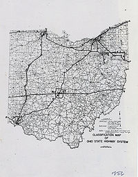
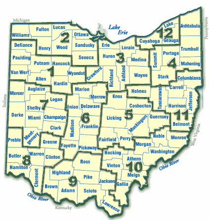
ODOT has broken up the state of Ohio into 12 districts in order to facilitate regional development. Each district is responsible for the planning, design, construction and maintenance of the state and federal highway
s in their region. The department employs over 6,000 people statewide, and has an annual budget approaching $3 billion. It celebrated its 100th anniversary in 2005, and its 35th as the Ohio Department of Transportation in 2007.
in an attempt to reduce the amount of automobile-related fatalities
in 1933. By the end of the year the first patrolmen were on duty.
signed the Federal Aid Highway Act of 1956
into law, designating highways for each state to build with federal
assistance to create the modern interstate highway system
. One year later in 1957 The Ohio’s Department of Highways officially began construction on the 1500 miles (2,414 km) of the interstate system designated for Ohio in the Federal Aid Highway Act. After one year of interstate construction Ohio was spending more on roadway construction than New York or California, and by 1962 had 684 miles (1,100.8 km) of interstates open. By the end of the decade Ohio hit a milestone with over 1000 miles (1,609.3 km) completed.
In 1965 the federal government began to allow new federal funds to be spent on highway beautification projects. The Ohio Department of Highways took a leading role in this national initiative, creating a new Design Services Division to oversee rest areas and landscaping along thousands of miles of state and interstate roadways in Ohio. In an effort to consolidate multiple modes of transportation under one agency, the Ohio Department of Highways officially became the Ohio Department of Transportation in September 1972. Throughout the decade construction of interstate highways continued. Two more milestones were reached during this period, with the full outerbelt (Interstate 270
) being completed around Columbus in 1975, as well as Interstate 70 traveling east to west through the heart of Ohio in 1976.
Since downsizing, ODOT has become more efficient in most areas of operation. Between 1997 and 2004, deficiencies were reduced significantly. Bridge structural deficiencies were reduced 74%, pavement deficiencies were reduced 79%, and guardrail deficiencies were reduced 70%. In addition, snow and ice removal efforts were improved.
unveiled his 10-year, $5 billion, Jobs and Progress plan. The plan was developed in order to supply $500 million annually to ODOT for new construction and revitalization projects designed to ease freeway congestion, improve road safety, and connect rural regions of Ohio. The plan is also estimated to create over 4,000 highway construction jobs. One month later ODOT completed Interstate 670
in Columbus, marking the completion of the original interstate highway plan in Ohio.
 Ohio's interstate highway system is approaching 50 years old and many highways are reaching the end of their designed lives
. Commercial truck traffic alone had grown 90 percent in the last quarter century and is estimated to grow another 60 percent by 2020. This forced ODOT to create a statewide plan to address congestion issues as well as the repair of aging interstate highways. ODOT currently manages 17 major studies or projects, ranging from bridge construction to intersection redesign. Major projects generally involve creating greater allowances for traffic flow and easing congestion.
Study to develop a comprehensive strategy to rebuild portions of Interstate 71, Interstate 77, and Interstate 90 into downtown Cleveland. The focus of the project is reducing inner-city congestion, replacing or repairing older sections of the freeway system, and improving the safety of the system. Of particular interest to ODOT is the safety of the Cleveland Innerbelt and Dead Man's Curve
, both of which experience an accident rate higher than the national average. In addition, ODOT plans to construct a new single-tower cable-stayed bridge
north of the current bridge for westbound traffic on Interstate 90 over the Cuyahoga River
Valley.
Construction was originally planned for 2009, though resistance from some citizens in the community has put the entire project in question. Complaints have been raised over the plan to build the new bridge north of the current span over the Cuyahoga River, mostly due to the effect the construction would have on day-to-day life and the loss of historical buildings and landmarks. In addition, complaints have been raised about the cost of the project which has been raised from the original $800 million to $1–1.5 billion. While the cost of the plan is mostly the construction of two new bridges over fifteen years, many in the community feel the rehabilitation of the existing bridges would be more cost effective. An unofficial estimate for bridge rehabilitation puts the cost at $268 million, or $366 million for the entire innerbelt project.
through Downtown Dayton
is in the process of being upgraded and modernized over the next 10–12 years. Construction includes widening Interstate 75 from Neva Drive through US 35 in Dayton to three through lanes as well as additional lanes for exiting. Also, a new interchange at Route 4 and Interstate 75 is being constructed as part of the project. As part of another phase in the project, ODOT will modify the US 35 interchange to provide three continuous lanes in each direction on I-75. All of the phases of this construction will be done at an estimated cost of $533 million. Construction of the last phase is estimated to be completed by 2016.
On February 26, 2009, the state of Ohio awarded a contract for $22 million dollars to construct an interchange at Austin Boulevard and Interstate 75 in Springboro, Ohio
in southern Montgomery county. Construction on the interchange began in April 2009 and was completed in July 2010. As part of the project, ODOT reconstructed the intersection of SR 741 and Miamisburg-Springboro Pike by widening lanes and adding a two leg continuous flow intersection
.
. The project is expected to cost around $800 million and begin in 2011.
, the department initiated the Veterans' Glass City Skyway project, with an estimated price tag of $234 million. The six-lane, single-tower cable-stayed bridge
design includes glass panels along all four faces of the tower and LED
s installed within, allowing for customizable lighting effects on the bridge. The original completion date was for May 2006, but the project was struck with a sixteen month delay after an accident killed four workers on February 16, 2004. This delayed the initial opening of the skyway until June 24, 2007.
(SPUI), and add through lanes for both I-270 and SR-161. The project was competed in the fall of 2008.
I-75/I-475
Interchange Study, the North Central Outerbelt Study (I-270
), the Akron
Central Interchange Project (I-76). and the US 35 Corridor Major Investment Study (MIS).
s, 6,200 on/off ramps, 5,000 stop signs, 3,400 intersections, and 3100 miles (4,989 km) of guard rail.
(For a complete list of all roads maintained by ODOT, see List of numbered highways in Ohio.)
s, the same construction type as the bridge that collapsed in Minnesota
on August 1, 2007. Of these, six are on the interstate highway system and four of those are in some stage of replacement.
, project and bridge design, and traffic. The department also oversees contracting consultants and coordinating right-of-way and utilities for projects. The principal responsibilities of the highway management department are road maintenance and snow and ice
removal. Besides these, the department also manages traffic signal
s, materials testing, bridge inspection, construction contracts, road sign
s, and highway striping. The final department making up each district of the Ohio Department of Transportation is business and human services. This department is responsible for work safety programs, labor contract management, personnel administration, accounting, information technology, budget and purchasing management, the operation and maintenance of district-wide facilities.
District 2
District 3
District 4
District 5
District 6
District 7
District 8
District 9
District 10
District 11
District 12
tube counters and then generate a Traffic Survey Report. The majority of sensors exist within the major cities, though more are planned for installation throughout the state. The department also partners with the Ohio Department of Public Safety to monitor traffic related crashes. Traffic crash reports are entered into a database that is shared by both departments. This Base Transportation Reporting System (BTRS) allows ODOT to review the number, frequency and severity of accidents that occur on its system. Traffic engineering
is then used to establish safety threshold numbers and signal areas of concern for traffic safety.
In 2000, ODOT began installing pavement
sensors and Global Positioning System
(GPS) tracking devices, as well as generating computer-modeled snow plow routes to enhance its snow and ice removal program. The pavement sensors relay valuable information such as pavement and air temperature, precipitation
accumulation and wind speed. By identifying and reporting weather conditions on the highway, the sensors help ODOT prioritize its response and more efficiently clear the roads. A number of pavement sensors currently exist on highways around the state. Data from these sensors is transferred to ODOT's district offices, and entered into the Road and Weather Information System(RWIS) on the ODOT web site. Motorists can track winter weather conditions by accessing RWIS on the internet. RWIS also lists winter weather advisories, snow warnings, and highway closures. The information is kept current and is available 24 hours per day.
Computer modeling software is also used to plan plow routes for each county. Data on equipment capabilities, personnel resources, facility locations and highway types is entered into the system. Highway layouts and the locations of available plows and salt stores are then examined, to determine the most effective routes for snow plows and salt spreading equipment. Global Positioning System (GPS) devices were also installed on ODOT vehicles, to help monitor the locations of ODOT equipment. This allows the department to track the exact location of snow removal
equipment and determine which routes have already been serviced.
Cincinnati
Cleveland
Columbus
Dayton
Toledo
Road
A road is a thoroughfare, route, or way on land between two places, which typically has been paved or otherwise improved to allow travel by some conveyance, including a horse, cart, or motor vehicle. Roads consist of one, or sometimes two, roadways each with one or more lanes and also any...
in the state of Ohio
Ohio
Ohio is a Midwestern state in the United States. The 34th largest state by area in the U.S.,it is the 7th‑most populous with over 11.5 million residents, containing several major American cities and seven metropolitan areas with populations of 500,000 or more.The state's capital is Columbus...
with exception of the Ohio Turnpike
Ohio Turnpike
The Ohio Turnpike, officially the James W. Shocknessy Ohio Turnpike, is a -long, limited-access toll highway in the U.S. state of Ohio, serving as a primary corridor to Chicago and Pittsburgh...
. In addition to highways, the department also helps develop public transportation and public aviation programs. ODOT is headquartered in Columbus
Columbus, Ohio
Columbus is the capital of and the largest city in the U.S. state of Ohio. The broader metropolitan area encompasses several counties and is the third largest in Ohio behind those of Cleveland and Cincinnati. Columbus is the third largest city in the American Midwest, and the fifteenth largest city...
, Ohio and is part of the executive branch
Executive (government)
Executive branch of Government is the part of government that has sole authority and responsibility for the daily administration of the state bureaucracy. The division of power into separate branches of government is central to the idea of the separation of powers.In many countries, the term...
of the Ohio
Government of Ohio
The government of the state of Ohio comprises three branches executive, legislative, and judicial. Its basic structure is set forth in the Ohio Constitution.-Executive Branch:...
state government
State government
A state government is the government of a subnational entity in a federal form of government, which shares political power with the federal or national government. A state government may have some level of political autonomy, or be subject to the direct control of the federal government...
. The Director of Transportation is part of the Governor's Cabinet
Cabinet of the Governor of Ohio
The statutes of the State of Ohio have established 26 departments of government which are responsible to the Governor. These departments are led by the Director, or in some cases the Commissioner, who must inform and assist the governor in the operation of the state...
.
ODOT has broken up the state of Ohio into 12 districts in order to facilitate regional development. Each district is responsible for the planning, design, construction and maintenance of the state and federal highway
United States Numbered Highways
The system of United States Numbered Highways is an integrated system of roads and highways in the United States numbered within a nationwide grid...
s in their region. The department employs over 6,000 people statewide, and has an annual budget approaching $3 billion. It celebrated its 100th anniversary in 2005, and its 35th as the Ohio Department of Transportation in 2007.
History
Origins
The Ohio Department of Highways began operations on February 15, 1905. The original office consisted of 4 employees and an annual budget of $10,000. Its mission was to study the state roads and the science of road construction. The Department of Highways created the first Ohio State Highway PatrolOhio State Highway Patrol
The Ohio State Highway Patrol is a division of the Ohio Department of Public Safety and is the official highway patrol agency of Ohio. The several missions of the Patrol include providing roadway patrol, emergency response to all public lands, the investigation of crimes which occur on state...
in an attempt to reduce the amount of automobile-related fatalities
Transportation safety in the United States
Transportation safety has steadily improved in the United States for many decades. Between 1920 and 2000, the rate of fatal automobile accidents per vehicle-mile decreased by a factor of about 17. Except for a pause during the 1960s, progress in reducing fatal accidents has been steady. Safety for...
in 1933. By the end of the year the first patrolmen were on duty.
Interstate highway era
On June 29, 1956 President Dwight D. EisenhowerDwight D. Eisenhower
Dwight David "Ike" Eisenhower was the 34th President of the United States, from 1953 until 1961. He was a five-star general in the United States Army...
signed the Federal Aid Highway Act of 1956
Federal Aid Highway Act of 1956
The Federal-Aid Highway Act of 1956, popularly known as the National Interstate and Defense Highways Act , was enacted on June 29, 1956, when Dwight D. Eisenhower signed the bill into law...
into law, designating highways for each state to build with federal
Federal government of the United States
The federal government of the United States is the national government of the constitutional republic of fifty states that is the United States of America. The federal government comprises three distinct branches of government: a legislative, an executive and a judiciary. These branches and...
assistance to create the modern interstate highway system
Interstate Highway System
The Dwight D. Eisenhower National System of Interstate and Defense Highways, , is a network of limited-access roads including freeways, highways, and expressways forming part of the National Highway System of the United States of America...
. One year later in 1957 The Ohio’s Department of Highways officially began construction on the 1500 miles (2,414 km) of the interstate system designated for Ohio in the Federal Aid Highway Act. After one year of interstate construction Ohio was spending more on roadway construction than New York or California, and by 1962 had 684 miles (1,100.8 km) of interstates open. By the end of the decade Ohio hit a milestone with over 1000 miles (1,609.3 km) completed.
In 1965 the federal government began to allow new federal funds to be spent on highway beautification projects. The Ohio Department of Highways took a leading role in this national initiative, creating a new Design Services Division to oversee rest areas and landscaping along thousands of miles of state and interstate roadways in Ohio. In an effort to consolidate multiple modes of transportation under one agency, the Ohio Department of Highways officially became the Ohio Department of Transportation in September 1972. Throughout the decade construction of interstate highways continued. Two more milestones were reached during this period, with the full outerbelt (Interstate 270
Interstate 270 (Ohio)
Interstate 270 is the beltway loop freeway in the Columbus metropolitan area, commonly known locally as "The Outerbelt," or the "Jack Nicklaus Freeway." The "western" terminus of I-270, at least in terms of the zero-milepost, is at the junction with I-71 east of Grove City, Ohio...
) being completed around Columbus in 1975, as well as Interstate 70 traveling east to west through the heart of Ohio in 1976.
Downsizing
In 1995, ODOT began efforts to become more efficient as well as be more customer-friendly. At the time ODOT employed 7,800 employees. By 2000, the total number of employees had been reduced to 6,031, a 22.6% decrease in 5 years. This move reduced the increase in payroll expenditures to 0.78% per year. In addition, non-payroll budgets were limited to a 2% annual increase since 1995. Since the Ohio Department of Transportation is managed by separate districts, district budgets were redesigned to allow any operational efficiencies to remain within the district. This allowed each district to reinvest into their own roads and bridges, provided they are able to spend less than their budget. A comprehensive set of measures and objectives have been adopted in order to oversee each district's performance.Since downsizing, ODOT has become more efficient in most areas of operation. Between 1997 and 2004, deficiencies were reduced significantly. Bridge structural deficiencies were reduced 74%, pavement deficiencies were reduced 79%, and guardrail deficiencies were reduced 70%. In addition, snow and ice removal efforts were improved.
Jobs and Progress plan
On August 5, 2003 Governor Bob TaftBob Taft
Robert Alphonso "Bob" Taft II is an Ohio Republican Party politician. He was elected to two terms of office as the 67th Governor of the U.S. state of Ohio between 1999-2007. After leaving office, Taft started working for the University of Dayton beginning August 15, 2007.-Personal background:Taft...
unveiled his 10-year, $5 billion, Jobs and Progress plan. The plan was developed in order to supply $500 million annually to ODOT for new construction and revitalization projects designed to ease freeway congestion, improve road safety, and connect rural regions of Ohio. The plan is also estimated to create over 4,000 highway construction jobs. One month later ODOT completed Interstate 670
Interstate 670 (Ohio)
Interstate 670 is an Interstate Highway in the U.S. state of Ohio that passes through downtown Columbus, connecting I-70 west of downtown with I-270 and US 62 near the eastern suburb of Gahanna. I-670 provides access to Port Columbus International Airport, and intersects SR 315 and I-71 downtown...
in Columbus, marking the completion of the original interstate highway plan in Ohio.
Studies and projects
Design life
The design life of a component or product is the period of time during which the item is expected by its designers to work within its specified parameters; in other words, the life expectancy of the item...
. Commercial truck traffic alone had grown 90 percent in the last quarter century and is estimated to grow another 60 percent by 2020. This forced ODOT to create a statewide plan to address congestion issues as well as the repair of aging interstate highways. ODOT currently manages 17 major studies or projects, ranging from bridge construction to intersection redesign. Major projects generally involve creating greater allowances for traffic flow and easing congestion.
Cleveland Urban Core Projects
In August 2000 ODOT began the Cleveland InnerbeltInnerbelt Freeway
An Innerbelt Freeway is a set of freeway facilities arranged in a loop that serves the interior of a major city, primarily as a traffic reliever for downtown commuters...
Study to develop a comprehensive strategy to rebuild portions of Interstate 71, Interstate 77, and Interstate 90 into downtown Cleveland. The focus of the project is reducing inner-city congestion, replacing or repairing older sections of the freeway system, and improving the safety of the system. Of particular interest to ODOT is the safety of the Cleveland Innerbelt and Dead Man's Curve
Dead Man's Curve
"Dead Man's Curve" is the unofficial but commonly used name given to hazardous curves on Interstate Highways and other roads in the United States that have claimed lives because of accidents.-Cleveland Innerbelt:...
, both of which experience an accident rate higher than the national average. In addition, ODOT plans to construct a new single-tower cable-stayed bridge
Cable-stayed bridge
A cable-stayed bridge is a bridge that consists of one or more columns , with cables supporting the bridge deck....
north of the current bridge for westbound traffic on Interstate 90 over the Cuyahoga River
Cuyahoga River
The Cuyahoga River is located in Northeast Ohio in the United States. Outside of Ohio, the river is most famous for being "the river that caught fire", helping to spur the environmental movement in the late 1960s...
Valley.
Construction was originally planned for 2009, though resistance from some citizens in the community has put the entire project in question. Complaints have been raised over the plan to build the new bridge north of the current span over the Cuyahoga River, mostly due to the effect the construction would have on day-to-day life and the loss of historical buildings and landmarks. In addition, complaints have been raised about the cost of the project which has been raised from the original $800 million to $1–1.5 billion. While the cost of the plan is mostly the construction of two new bridges over fifteen years, many in the community feel the rehabilitation of the existing bridges would be more cost effective. An unofficial estimate for bridge rehabilitation puts the cost at $268 million, or $366 million for the entire innerbelt project.
Dayton Area Projects
Interstate 75Interstate 75
Interstate 75 is a major north–south Interstate Highway in the Great Lakes and Southeastern regions of the United States. It travels from State Road 826 and State Road 924 in Hialeah, Florida to Sault Ste. Marie, Michigan, at the Ontario, Canada, border...
through Downtown Dayton
Dayton
Dayton is a city in Ohio and the county seat of Montgomery County, Ohio, United States.Dayton may also refer to:-United States:*Dayton, Alabama*Dayton, California, in Butte County*Dayton, Lassen County, California*Dayton, Idaho*Dayton, Indiana...
is in the process of being upgraded and modernized over the next 10–12 years. Construction includes widening Interstate 75 from Neva Drive through US 35 in Dayton to three through lanes as well as additional lanes for exiting. Also, a new interchange at Route 4 and Interstate 75 is being constructed as part of the project. As part of another phase in the project, ODOT will modify the US 35 interchange to provide three continuous lanes in each direction on I-75. All of the phases of this construction will be done at an estimated cost of $533 million. Construction of the last phase is estimated to be completed by 2016.
On February 26, 2009, the state of Ohio awarded a contract for $22 million dollars to construct an interchange at Austin Boulevard and Interstate 75 in Springboro, Ohio
Springboro, Ohio
Springboro is an affluent suburb of Cincinnati and Dayton located in Warren and Montgomery counties in the U.S. state of Ohio. It is in Warren County's Clearcreek and Franklin Townships and Montgomery County's Miami Township...
in southern Montgomery county. Construction on the interchange began in April 2009 and was completed in July 2010. As part of the project, ODOT reconstructed the intersection of SR 741 and Miamisburg-Springboro Pike by widening lanes and adding a two leg continuous flow intersection
Continuous flow intersection
Continuous flow intersection , also called a crossover displaced left-turn , is an at-grade intersection that moves the turning vehicles, conflicting with the through-movements , out of the main intersection...
.
Columbus Crossroads Project
Another large-scale project ODOT is spearheading is the I-70/I-71 South Innerbelt Corridor Project, a multi-faceted plan to reduce congestion in downtown Columbus along the convergence of Interstate 70 and Interstate 71. Commonly known as "the downtown split," the region regularly experiences heavy traffic and is the site of 27% of all traffic accidents along I-70 and I-71 in Franklin county. In an effort to reduce traffic and accidents, as well as remove the confusion of getting on or off the freeway, the downtown split project will add lanes to the freeway in both directions, widen Mound and Fulton streets and convert them to one-way, collector/distributor streets, and move the current on/off-ramps to facilitate better traffic flowTraffic flow
Traffic flow, in mathematics and civil engineering, is the study of interactions between vehicles, drivers, and infrastructure , with the aim of understanding and developing an optimal road network with efficient movement of traffic and minimal traffic congestion problems.-History:Attempts to...
. The project is expected to cost around $800 million and begin in 2011.
Freeway caps
In addition to freeway construction, ODOT, along with the Mid-Ohio Regional Planning Commission (MORPC) and the city of Columbus are discussing the possibility of several freeway caps over portions of I-70 and I-71. These caps, similar to the one built on High Street over I-670, would be widened overpasses, creating a seamless transition between neighborhoods by adding businesses or parks to either side of the current overpass. While this will add considerable cost to the project, it is hoped that the freeway caps will link neighborhoods that were divided when the interstate highway system was put in. Twelve overpasses were originally looked at for freeway caps, though the list has been narrowed to six due to budget constraints. Each cap would cost anywhere between $2 million and $12 million dollars depending on the complexity, and a total of $53 million to $62 million could be added to the project if all six are built. The Ohio Department of Transportation has pledged $10 million toward caps, $37 million for streetscape improvements in total, and the MORPC has pledged another $12 million for the caps. With the caps and other streetscape improvements added to the project, total project cost is expected to reach $1 billion.Veterans' Glass City Skyway
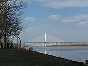
In March 2002 ODOT began the largest single project in their history. Needing a replacement for the outdated Craig Memorial Bridge in ToledoToledo, Ohio
Toledo is the fourth most populous city in the U.S. state of Ohio and is the county seat of Lucas County. Toledo is in northwest Ohio, on the western end of Lake Erie, and borders the State of Michigan...
, the department initiated the Veterans' Glass City Skyway project, with an estimated price tag of $234 million. The six-lane, single-tower cable-stayed bridge
Cable-stayed bridge
A cable-stayed bridge is a bridge that consists of one or more columns , with cables supporting the bridge deck....
design includes glass panels along all four faces of the tower and LED
Light-emitting diode
A light-emitting diode is a semiconductor light source. LEDs are used as indicator lamps in many devices and are increasingly used for other lighting...
s installed within, allowing for customizable lighting effects on the bridge. The original completion date was for May 2006, but the project was struck with a sixteen month delay after an accident killed four workers on February 16, 2004. This delayed the initial opening of the skyway until June 24, 2007.
Northeast Expressway Transformation
The Northeast Expressway Transformation (NExT) project, which began on June 14, 2004, marked another significant undertaking by ODOT as the largest single highway project ever in central Ohio. It includeed rebuilding the State Route 161 interchanges at Interstate 270 and Sunbury Road, including 17 bridges, 18 ramps and five miles (8 km) of highway. The original intersections at I-270 and Sunbury Road were designed to handle 58,000 and 21,000 vehicles per day respectively, but daily loads had surpassed 135,000 at I-270 and 90,000 at Sunbury Road. By 2020, loads are estimated to be approaching 200,000 vehicles per day at both interchanges. To meet and exceed current traffic needs, the project replaced three of the four cloverleaf ramps at I-270 with two flyover ramps and one 'flyunder' tunnel, reconfigured the Sunbury Road exit into a modified single-point urban interchangeSingle-point urban interchange
A single-point urban interchange , also called a single-point interchange or single-point diamond interchange , is a type of highway interchange...
(SPUI), and add through lanes for both I-270 and SR-161. The project was competed in the fall of 2008.
Other studies/projects
Other studies include the ToledoToledo, Ohio
Toledo is the fourth most populous city in the U.S. state of Ohio and is the county seat of Lucas County. Toledo is in northwest Ohio, on the western end of Lake Erie, and borders the State of Michigan...
I-75/I-475
Interstate 475 (Ohio)
Interstate 475 is an Interstate Highway in Ohio that is a western bypass of Toledo. The southern terminus is I-75 near Perrysburg. The northern terminus is I-75 near downtown Toledo...
Interchange Study, the North Central Outerbelt Study (I-270
Interstate 270 (Ohio)
Interstate 270 is the beltway loop freeway in the Columbus metropolitan area, commonly known locally as "The Outerbelt," or the "Jack Nicklaus Freeway." The "western" terminus of I-270, at least in terms of the zero-milepost, is at the junction with I-71 east of Grove City, Ohio...
), the Akron
Akron, Ohio
Akron , is the fifth largest city in the U.S. state of Ohio and the county seat of Summit County. It is located in the Great Lakes region approximately south of Lake Erie along the Little Cuyahoga River. As of the 2010 census, the city had a population of 199,110. The Akron Metropolitan...
Central Interchange Project (I-76). and the US 35 Corridor Major Investment Study (MIS).
Department management
The Ohio Department of Transportation currently operates the seventh largest highway system in the United States and the sixth largest interstate system measured by total lane-miles. These highways support the fifth greatest traffic volume by total vehicle miles, the third greatest value of commercial freight, and contain the second largest inventory of bridges in the nation as well. ODOT maintains approximately 49,000 lane miles of highway system statewide. Included with these highways are over 15,000 bridges and culvertCulvert
A culvert is a device used to channel water. It may be used to allow water to pass underneath a road, railway, or embankment. Culverts can be made of many different materials; steel, polyvinyl chloride and concrete are the most common...
s, 6,200 on/off ramps, 5,000 stop signs, 3,400 intersections, and 3100 miles (4,989 km) of guard rail.
(For a complete list of all roads maintained by ODOT, see List of numbered highways in Ohio.)
Budget
The 2006/2007 operating budget for the department is forecast at $2.898 billion, with $753 million going towards general operating expenditures and $724 million for new programs funded by the Jobs and Progress plan. Total revenue is expected to be $1.089 billion from the state and $1.247 billion from the federal government, equaling $2.336 billion. The remainder of funds are to come from state and federal bonds. Though ODOT currently plans on a 1% yearly growth in overall revenue through 2015, total expenditures are expected to see no growth through the same period. This is due in large part because the funding from the Jobs and Progress plan will even out to $500 million after 2009.Bridge inspection
The department runs an annual bridge inspection program as mandated by state law. Statewide, Ohio has 10,348 bridges owned by the state. In order to maintain all of its bridges, ODOT dedicates a significant portion of its budget to bridge construction and maintenance. For 2008, the department has allocated $239 million toward bridges, with an additional $91 million going towards assisting the bridge projects of counties and cities. The Ohio Department of Transportation is also responsible for twelve under-deck truss bridgeTruss bridge
A truss bridge is a bridge composed of connected elements which may be stressed from tension, compression, or sometimes both in response to dynamic loads. Truss bridges are one of the oldest types of modern bridges...
s, the same construction type as the bridge that collapsed in Minnesota
Minnesota
Minnesota is a U.S. state located in the Midwestern United States. The twelfth largest state of the U.S., it is the twenty-first most populous, with 5.3 million residents. Minnesota was carved out of the eastern half of the Minnesota Territory and admitted to the Union as the thirty-second state...
on August 1, 2007. Of these, six are on the interstate highway system and four of those are in some stage of replacement.
District management
All 12 districts of the Ohio Department of Transportation are divided into four departments which manage the many facets of state transportation. The planning and programs department is responsible for monitoring the district work program, monitoring department adherence to environmental regulations, ensuring community involvement in transportation decisions, and using budget allocations to select improvement projects. In addition, the department schedules the time frame for improvements, and secures the funding needed to design and construct improvements. The production department manages surveyingSurveying
See Also: Public Land Survey SystemSurveying or land surveying is the technique, profession, and science of accurately determining the terrestrial or three-dimensional position of points and the distances and angles between them...
, project and bridge design, and traffic. The department also oversees contracting consultants and coordinating right-of-way and utilities for projects. The principal responsibilities of the highway management department are road maintenance and snow and ice
Ice
Ice is water frozen into the solid state. Usually ice is the phase known as ice Ih, which is the most abundant of the varying solid phases on the Earth's surface. It can appear transparent or opaque bluish-white color, depending on the presence of impurities or air inclusions...
removal. Besides these, the department also manages traffic signal
Traffic light
Traffic lights, which may also be known as stoplights, traffic lamps, traffic signals, signal lights, robots or semaphore, are signalling devices positioned at road intersections, pedestrian crossings and other locations to control competing flows of traffic...
s, materials testing, bridge inspection, construction contracts, road sign
Traffic sign
Traffic signs or road signs are signs erected at the side of roads to provide information to road users. With traffic volumes increasing over the last eight decades, many countries have adopted pictorial signs or otherwise simplified and standardized their signs to facilitate international travel...
s, and highway striping. The final department making up each district of the Ohio Department of Transportation is business and human services. This department is responsible for work safety programs, labor contract management, personnel administration, accounting, information technology, budget and purchasing management, the operation and maintenance of district-wide facilities.
Regions
District 1- Deputy Director: Kirk Slusher P.E.
- Counties served: AllenAllen County, OhioAllen County is a county located in the U.S. state of Ohio. Its population was 106,331 as of the 2010 census. It is included in the Lima, Ohio Metropolitan Statistical Area as well as the Lima–Van Wert–Wapakoneta Combined Statistical Area....
, DefianceDefiance County, OhioAs of the census of 2000, there were 39,500 people, 15,138 households, and 11,020 families residing in the county. The population density was 96 people per square mile . There were 16,040 housing units at an average density of 39 per square mile...
, HancockHancock County, OhioHancock County is a county located in the state of Ohio, United States. As of the 2010 census, the population was 74,782. Its county seat is Findlay and was named for John Hancock, the first signer of the Declaration of Independence...
, HardinHardin County, OhioHardin County is a county located in the state of Ohio, United States. As of the 2010 census, the population was 32,058. Its county seat is Kenton and is named for John Hardin, an officer in the American Revolution.-Geography:According to the U.S...
, PauldingPaulding County, OhioAs of the census of 2000, there were 20,293 people, 7,773 households, and 5,689 families residing in the county. The population density was 49 people per square mile . There were 8,478 housing units at an average density of 20 per square mile...
, PutnamPutnam County, OhioPutnam County is a county located in the state of Ohio, United States. As of the 2010 census, the population was 34,499. The name is in honor of Israel Putnam, who was a hero in the French and Indian War and a general in the American Revolutionary War. Its county seat is...
, Van Wert, WyandotWyandot County, OhioAs of the census of 2000, there were 22,908 people, 8,882 households, and 6,270 families residing in the county. The population density was 56 people per square mile . There were 9,324 housing units at an average density of 23 per square mile...
District 2
- Deputy Director: Todd Audet P.E.
- Counties served: FultonFulton County, OhioFulton County is a county located in the U.S. state of Ohio. As of 2010, the population was 42,698. Its county seat is Wauseon. Fulton County is named for Robert Fulton, inventor of the steamboat....
, HenryHenry County, OhioHenry County is a county located in the state of Ohio, United States. As of the 2010 census, the population was 28,215. Its county seat is Napoleon and is named for Patrick Henry, the Virginian famous for his "give me liberty or give me death" speech....
, LucasLucas County, Ohio----...
, OttawaOttawa County, OhioOttawa County is a county located in the state of Ohio, United States. As of the 2010 census, the population was 41,428. Its county seat is Port Clinton and is named either for the Ottawa Indians who lived there, or for an Indian word meaning "trader"....
, SanduskySandusky County, OhioSandusky County is a county in the U.S. state of Ohio. As of the 2010 census, the population was 60,944. Its county seat is Fremont and it is named for a native word meaning "water" ....
, SenecaSeneca County, OhioSeneca County is a county located in the state of Ohio, United States. As of the 2010 census, the population was 56,745. Its county seat is Tiffin and it is named for the Seneca Indians.The Tiffin Micropolitan Statistical Area includes all of Seneca County....
, WilliamsWilliams County, OhioWilliams County is a county located in the U.S. state of Ohio. As of 2010, the population was 37,642. Its county seat is Bryan and is named for David Williams, one of the captors of John André in the American Revolutionary War.-Geography:According to the U.S...
, WoodWood County, OhioWood County is a county located in the state of Ohio, United States. As of the 2010 census, the population was 125,488. Its county seat is Bowling Green. The county was named for Captain Eleazer D. Wood, the engineer for General William Henry Harrison's army, who built Fort Meigs in the War of 1812...
District 3
- Deputy Director: Allen Biehl P.E.
- Counties served: AshlandAshland County, OhioAshland County is a county located in the state of Ohio, United States, and was formed in 1846 from parts of Huron, Lorain, Richland and Wayne Counties. As of the 2010 census, the population was 53,139. Its county seat is Ashland...
, CrawfordCrawford County, OhioCrawford County is a county located in the state of Ohio, United States. It was named for Colonel William Crawford, a soldier during the American Revolution....
, ErieErie County, OhioAs of the census of 2000, there were 79,551 people, 31,727 households, and 21,764 families residing in the county. The population density was 312 people per square mile . There were 35,909 housing units at an average density of 141 per square mile...
, HuronHuron County, OhioAs of the census of 2000, there were 59,487 people, 22,307 households, and 16,217 families residing in the county. The population density was 121 people per square mile . There were 23,594 housing units at an average density of 48 per square mile...
, LorainLorain County, OhioLorain County is a county located in the U.S. state of Ohio, and is considered to be a part of what is locally referred to as Greater Cleveland. As of the 2010 census, its population was 301,356. an increase from 284,664 in 2000...
, Medina, RichlandRichland County, OhioRichland County is a county located in the state of Ohio, United States. As of the 2010 census, the population was 124,475. It is included in the Mansfield, Ohio, Metropolitan Statistical Area as well as the Mansfield–Bucyrus Combined Statistical Area....
, WayneWayne County, OhioWayne County is a county located in the state of Ohio, United States, and is named for General "Mad" Anthony Wayne. As of the 2010 census, the population was 114,520. Its county seat is Wooster....
District 4
- Deputy Director: Anthony Urankar
- Counties served: AshtabulaAshtabula County, OhioAshtabula County is the northeasternmost county in the state of Ohio. As of 2010, the population was 101,497, its county seat is Jefferson. The county is named for a Native American word meaning "river of many fish"....
, Mahoning, PortagePortage County, OhioPortage County is a county located in the U.S. state of Ohio. The population was 152,061 at the 2000 Census and 161,419 at the 2010 Census. Its county seat is Ravenna. Portage County is named for the portage between the Cuyahoga and Tuscarawas Rivers...
, StarkStark County, OhioStark County is a county located in the U.S. state of Ohio. As of the 2010 census, the population was 375,586. It is included in the Canton-Massillon, Ohio Metropolitan Statistical Area....
, SummitSummit County, OhioSummit County is an urban county located in the state of Ohio, United States. As of the 2000 census, the population was 542,899. In the 2010 Census the population was 541,781. Its county seat is Akron...
, TrumbullTrumbull County, OhioAs of the census of 2000, there were 225,116 people, 89,020 households, and 61,690 families residing in the county. The population density was 365 people per square mile . There were 95,117 housing units at an average density of 154 per square mile...
District 5
- Deputy Director: Joe Rutherford
- Counties served: CoshoctonCoshocton County, OhioCoshocton County is a county located in the state of Ohio, United States. As of the 2010 census, the population was 36,901. Its county seat is Coshocton. Its name comes from the Delaware Indian language and has been translated as "union of waters" or "black bear crossing".The Coshocton...
, FairfieldFairfield County, OhioFairfield County is a county located in the state of Ohio, United States. As of 2010, the population was 146,156. Its county seat is Lancaster. Its name is a reference to the Fairfield area of the original Lancaster....
, GuernseyGuernsey County, OhioGuernsey County is a county located in the state of Ohio. As of 2010, the population was 40,087. Its county seat is Cambridge and is named for the Isle of Guernsey in the English Channel, from which many of the county's early settlers came....
, KnoxKnox County, OhioKnox County is a county located in the state of Ohio, United States. As of 2010, the population was 60,921. Its county seat is Mount Vernon and is named for Henry Knox, an officer in the American Revolutionary War who was later the first Secretary of War....
, LickingLicking County, OhioLicking County is a county located in the state of Ohio, United States. As of the 2010 census, the population was 166,492. Its county seat is Newark and is named for the salt licks that were in the area....
, MuskingumMuskingum County, OhioMuskingum County is a county located in the state of Ohio, United States. As of the 2010 census, the population was 86,074. Its county seat is Zanesville...
, PerryPerry County, OhioPerry County is a county located in the state of Ohio, United States. Founded on March 1, 1818, it was the 55th county to be formed in Ohio. Portions of Fairfield, Washington and Muskingum Counties were taken to create Perry County. As of the 2010 census, the population was 36,058. Its county seat...
District 6
- Deputy Director: Ferzan Ahmed P.E.
- Counties served: DelawareDelaware County, OhioDelaware County is a fast-growing suburban county in the state of Ohio, United States, within the Columbus, Ohio Metropolitan Statistical Area. According to the United States Census Bureau's 2004 population estimates, Delaware County's population of 142,503 made it the fastest growing county in...
, FayetteFayette County, OhioAs of the census of 2000, there were 28,433 people, 11,054 households, and 7,837 families residing in the county. The population density was 70 people per square mile . There were 11,904 housing units at an average density of 29 per square mile...
, FranklinFranklin County, OhioFranklin County is a county located in the state of Ohio, United States. In 2010 the population was 1,163,414, making it the second largest county in Ohio and the 34th largest county in population in the United States. Franklin County is also the largest in the eight-county Columbus, Ohio...
, MadisonMadison County, OhioAs of the census of 2000, there were 40,213 people, 13,672 households, and 10,035 families residing in the county. The population density was 86 people per square mile . There were 14,399 housing units at an average density of 31 per square mile...
, MarionMarion County, OhioMarion County is a county located in the state of Ohio, United States. As of the 2010 census, the population was 66,501. Its county seat is the city of Marion and is named for General Francis "The Swamp Fox" Marion, an officer in the Revolutionary War....
, MorrowMorrow County, OhioMorrow County is a county located in the state of Ohio, United States. Shawnee people used the area for hunting purposes before white settlers arrived in the early 19th century. Morrow County was organized in 1848 from parts of four neighboring counties and named for Jeremiah Morrow, Governor of...
, PickawayPickaway County, OhioAs of the census of 2000, there were 52,727 people, 17,599 households, and 13,287 families residing in the county. The population density was 105 people per square mile . There were 18,596 housing units at an average density of 37 per square mile...
, UnionUnion County, OhioUnion County is a county located in the US state of Ohio. As of the 2010 census, the population was 52,300. Increasingly becoming more of a suburban county, the population was estimated at 47,234 in 2007 by the U.S. Census Bureau...
District 7
- Deputy Director: Randy Chevalley P.E. P.S.
- Counties served: AuglaizeAuglaize County, OhioAs of the census of 2000, there were 46,611 people, 17,376 households, and 12,771 families residing in the county. The population density was 116 people per square mile . There were 18,470 housing units at an average density of 46 per square mile...
, ChampaignChampaign County, OhioAs of the census of 2000, there were 38,890 people, 14,952 households, and 10,870 families residing in the county. The population density was 91 people per square mile . There were 15,890 housing units at an average density of 37 per square mile...
, ClarkClark County, OhioAs of the census of 2000, there were 144,742 people, 56,648 households, and 39,370 families residing in the county. The population density was 362 people per square mile . There were 61,056 housing units at an average density of 153 per square mile...
, DarkeDarke County, OhioAs of the census of 2000, there were 53,309 people, 20,419 households, and 14,905 families residing in the county. The population density was 89 people per square mile . There were 21,583 housing units at an average density of 36 per square mile...
, LoganLogan County, OhioLogan County is a county in the state of Ohio, United States. As of the 2010 census, the population was 45,858. The county seat is Bellefontaine. The county is named for Benjamin Logan, who fought Native Americans in the area....
, MercerMercer County, OhioMercer County is a county located in the state of Ohio, United States. Its county seat is Celina and is named for Hugh Mercer, an officer in the American Revolutionary War.The Celina Micropolitan Statistical Area includes all of Mercer County.-Geography:...
, MiamiMiami County, OhioAs of the census of 2000, there were 98,868 people, 38,437 households, and 27,943 families residing in the county. The population density was 243 people per square mile . There were 40,554 housing units at an average density of 100 per square mile...
, MontgomeryMontgomery County, OhioMontgomery County is a county located in the state of Ohio, United States. The population was 535,153 in the 2010 Census. It was named in honor of Richard Montgomery, an American Revolutionary War general killed in 1775 while attempting to capture Quebec City, Canada. The county seat is Dayton...
, ShelbyShelby County, OhioAs of the census of 2000, there were 47,910 people, 17,636 households, and 13,085 families residing in the county. The population density was 117 people per square mile . There were 18,682 housing units at an average density of 46 per square mile...
District 8
- Deputy Director: Steve Mary P.E.
- Counties served: ButlerButler County, OhioButler County is a county located in the state of Ohio, United States. As of 2010, the population was 368,130. Its county seat is Hamilton. It is named for General Richard Butler, who died in 1791 fighting Indians in northern Ohio. Butler's army marched out of Fort Hamilton, where the city of...
, ClermontClermont County, OhioClermont County is a county located in the state of Ohio, United States, just east of Cincinnati. As of 2010, the population was 197,363. Its county seat is Batavia...
, ClintonClinton County, OhioClinton County is a county located in the state of Ohio, United States. As of the 2010 census, the population was 42,040. The 2008 Census Population Estimate places the figure at 43,200. It is named for former U.S. Vice-President George Clinton...
, GreeneGreene County, OhioGreene County is a county located in the state of Ohio, United States. The population was 161,573 in the 2010 Census. Its county seat is Xenia, and it was named for General Nathanael Greene, an officer in the Revolutionary War. Greene County was established on March 24, 1803.Greene County is part...
, HamiltonHamilton County, OhioAs of 2000, there were 845,303 people, 346,790 households, and 212,582 families residing in the county. The population density was 2,075 people per square mile . There were 373,393 housing units at an average density of 917 per square mile...
, PreblePreble County, OhioAs of the census of 2000, there were 42,337 people, 16,001 households, and 12,144 families residing in the county. The population density was 100 people per square mile . There were 17,186 housing units at an average density of 40 per square mile...
, WarrenWarren County, OhioWarren County is a county located in the state of Ohio, United States. The population was 212,693 at the 2010 census. Its county seat is Lebanon. Warren County was erected May 1, 1803, from Hamilton County, and named for Dr...
District 9
- Deputy Director: Vaughn Wilson P.E.
- Counties served: AdamsAdams County, OhioAs of the census of 2000, there were 27,330 people, 10,501 households, and 7,613 families residing in the county. The population density was 47 people per square mile . There were 11,822 housing units at an average density of 20 per square mile...
, BrownBrown County, OhioAs of the census of 2000, there were 42,285 people, 15,555 households, and 11,790 families residing in the county. The population density was 86 people per square mile . There were 17,193 housing units at an average density of 35 per square mile...
, HighlandHighland County, OhioAs of the census of 2000, there were 40,875 people, 15,587 households, and 11,394 families residing in the county. The population density was 74 people per square mile . There were 17,583 housing units at an average density of 32 per square mile...
, JacksonJackson County, OhioJackson County is a county located in the state of Ohio, United States. As of 2010, the population was 33,225. Its county seat is Jackson and is named for Andrew Jackson, a hero of the War of 1812 who was subsequently elected President of the United States....
, LawrenceLawrence County, OhioAs of the census of 2000, there were 62,319 people, 24,732 households, and 17,807 families residing in the county. The population density was 137 people per square mile . There were 27,189 housing units at an average density of 60 per square mile...
, PikePike County, OhioAs of the census of 2000, there were 27,695 people, 10,444 households, and 7,665 families residing in the county. The population density was 63 people per square mile . There were 11,602 housing units at an average density of 26 per square mile...
, RossRoss County, OhioAs of the census of 2000, there were 73,345 people, 27,136 households, and 19,185 families residing in the county. The population density was 106 people per square mile . There were 29,461 housing units at an average density of 43 per square mile...
, SciotoScioto County, OhioAs of the census of 2000, there were 79,195 people, 30,871 households, and 21,362 families residing in the county. The population density was 129 people per square mile . There were 34,054 housing units at an average density of 56 per square mile...
District 10
- Deputy Director: Steve Williams P.E.
- Counties served: AthensAthens County, OhioAs of the census of 2000, there were 62,223 people, 22,501 households, and 12,713 families residing in the county. The population density was 123 people per square mile . There were 24,901 housing units at an average density of 49 per square mile...
, GalliaGallia County, OhioAs of the census of 2000, there were 31,069 people, 12,060 households, and 8,586 families residing in the county. The population density was 66 people per square mile . There were 13,498 housing units at an average density of 29 per square mile...
, HockingHocking County, OhioHocking County is a county located in the state of Ohio, United States. As of 2010, the population was 29,380. Its county seat is Logan. Its name is from the Hocking River, the origins of which are disputed but is said to be a Delaware Indian word meaning "bottle river".-Geography:According to the...
, MeigsMeigs County, OhioMeigs County is a county located in the state of Ohio, United States. As of the 2010 census, the population was 23,770. Its county seat is Pomeroy, and it is named for Return J. Meigs, Jr., the 4th Governor of Ohio.-Geography:...
, MonroeMonroe County, OhioMonroe County is a county located in the state of Ohio. As of the 2010 census, the population was 14,642. Its county seat is Woodsfield and is named for James Monroe, Secretary of State when the county was formed and later President of the United States....
, MorganMorgan County, Ohio**----...
, NobleNoble County, OhioNoble County is a county located in the state of Ohio. As of the 2010 census, the population was 14,645. Its county seat is Caldwell. Noble County is named for Rep. Warren P. Noble of the Ohio House of Representatives, who was an early settler there.-History:...
, VintonVinton County, OhioVinton County is a county located in the state of Ohio, United States. As of the 2010 census, the population was 13,435. , the least populous in the state. Its county seat is McArthur. The county is named for Samuel Finley Vinton, a 19th-century United States Congressman from...
, WashingtonWashington County, OhioWashington County is a county located in the state of Ohio. As of the 2010 census, the population was 61,778. Its county seat is Marietta. The county, the oldest in the state, is named for George Washington. Washington County is included in the Parkersburg-Marietta-Vienna, West Virginia-Ohio...
District 11
- Deputy Director: Lloyd MacAdam P.E. P.S.
- Counties served: BelmontBelmont County, OhioBelmont County is a county located in the U.S. state of Ohio. It is part of the Wheeling, West Virginia Metropolitan Statistical Area. As of 2010, the population was 70,400. Its county seat is St. Clairsville...
, CarrollCarroll County, OhioCarroll County is a county located in the state of Ohio. As of 2010, the population was 28,836, no change from 2000. Its county seat is Carrollton. It is named for Charles Carroll of Carrollton, the last surviving signer of the Declaration of Independence....
, ColumbianaColumbiana County, OhioColumbiana County is a county located in the U.S. state of Ohio. As of 2010, the population was 107,841. It is named for Christopher Columbus and the county seat is Lisbon....
, Harrison, JeffersonJefferson County, OhioJefferson County is a county located in the state of Ohio. As of 2010, the population was 69,709. Its county seat is Steubenville and is named for Thomas Jefferson, who was at the time Vice President....
, TuscarawasTuscarawas County, OhioTuscarawas County is a county located in the eastern part of the state of Ohio. As of the 2010 census, the population was 92,582. Its county seat is New Philadelphia...
District 12
- Deputy Director: Myron Pakush
- Counties served: CuyahogaCuyahoga County, OhioCuyahoga County is a county located in the state of Ohio, United States. It is the most populous county in Ohio; as of the 2010 census, the population was 1,280,122. Its county seat is Cleveland. Cuyahoga County is part of Greater Cleveland, a metropolitan area, and Northeast Ohio, a...
, GeaugaGeauga County, OhioGeauga County is a county located in the state of Ohio, United States. As of the 2010 census, the population was 93,389. It is named for a Native American word meaning "raccoon". The county seat is Chardon...
, LakeLake County, OhioLake County is a county located in the U.S. state of Ohio. As of 2010, the population was 230,041. The county seat is Painesville, and the county name comes from its location on the southern shore of Lake Erie....
Highway safety
ODOT measures the traffic volumes on its roadways via Automated Traffic Recorders (ATRs), time-lapsed videos, and piezometricPiezometer
A piezometer is either a device used to measure static liquid pressure in a system by measuring the height to which a column of the liquid rises against gravity, or a device which measures the pressure of groundwater at a specific point...
tube counters and then generate a Traffic Survey Report. The majority of sensors exist within the major cities, though more are planned for installation throughout the state. The department also partners with the Ohio Department of Public Safety to monitor traffic related crashes. Traffic crash reports are entered into a database that is shared by both departments. This Base Transportation Reporting System (BTRS) allows ODOT to review the number, frequency and severity of accidents that occur on its system. Traffic engineering
Traffic engineering (transportation)
For the engineering of communications and computer networks, see Teletraffic engineering.Traffic engineering is a branch of civil engineering that uses engineering techniques to achieve the safe and efficient movement of people and goods on roadways...
is then used to establish safety threshold numbers and signal areas of concern for traffic safety.
Snow and ice safety
The Ohio Department of Transportation currently has access to 1,536 snow plows to help maintain good road conditions during winter months, and has approximately 2,500 employees available each season for snow and ice removal. In addition to trucks, the department also has 400,000 tons of salt stored at 222 locations statewide. While ODOT spends an average of $24 million per year for winter operations, though most years can use anywhere from 300,000 to 550,000 tons of salt per year. ODOT now manages a decentralized snow and ice program, giving districts, counties, and snow plow operators a set of guidelines to follow, which can be modified to best assist the area. In prior years, the department issued twelve pages of directives that mandated when and where plows are to be used. This system proved to be inefficient, which helped to bring the new system about.In 2000, ODOT began installing pavement
Pavement (material)
Road surface or pavement is the durable surface material laid down on an area intended to sustain vehicular or foot traffic, such as a road or walkway. In the past cobblestones and granite setts were extensively used, but these surfaces have mostly been replaced by asphalt or concrete. Such...
sensors and Global Positioning System
Global Positioning System
The Global Positioning System is a space-based global navigation satellite system that provides location and time information in all weather, anywhere on or near the Earth, where there is an unobstructed line of sight to four or more GPS satellites...
(GPS) tracking devices, as well as generating computer-modeled snow plow routes to enhance its snow and ice removal program. The pavement sensors relay valuable information such as pavement and air temperature, precipitation
Precipitation (meteorology)
In meteorology, precipitation In meteorology, precipitation In meteorology, precipitation (also known as one of the classes of hydrometeors, which are atmospheric water phenomena is any product of the condensation of atmospheric water vapor that falls under gravity. The main forms of precipitation...
accumulation and wind speed. By identifying and reporting weather conditions on the highway, the sensors help ODOT prioritize its response and more efficiently clear the roads. A number of pavement sensors currently exist on highways around the state. Data from these sensors is transferred to ODOT's district offices, and entered into the Road and Weather Information System(RWIS) on the ODOT web site. Motorists can track winter weather conditions by accessing RWIS on the internet. RWIS also lists winter weather advisories, snow warnings, and highway closures. The information is kept current and is available 24 hours per day.
Computer modeling software is also used to plan plow routes for each county. Data on equipment capabilities, personnel resources, facility locations and highway types is entered into the system. Highway layouts and the locations of available plows and salt stores are then examined, to determine the most effective routes for snow plows and salt spreading equipment. Global Positioning System (GPS) devices were also installed on ODOT vehicles, to help monitor the locations of ODOT equipment. This allows the department to track the exact location of snow removal
Snow removal
Snow removal is the job of removing snow after a snowfall to make travel easier and safer. This is done by both individual households and by governments and institutions.-De-icing and anti-icing:...
equipment and determine which routes have already been serviced.
External links
- Ohio Department of Transportation – official ODOT website
- BuckeyeTraffic.org – ODOT traffic and roadway information
- ODOT Traffic Webcams – ODOT Traffic Webcams
Recent and current projects
AkronCincinnati
Cleveland
Columbus
- Interstate 670 Completion Project
- Northeast Expressway Transformation Project
- North Central Outerbelt Study
- I-70/I-71 South Innerbelt Corridor Study
Dayton
Toledo