

Perry County, Ohio
Encyclopedia
Perry County is a county located in the state
of Ohio
, United States
. Founded on March 1, 1818, it was the 55th county to be formed in Ohio. Portions of Fairfield, Washington and Muskingum Counties were taken to create Perry County. As of the 2010 census, the population was 36,058. http://quickfacts.census.gov/qfd/states/39/39127.html Its county seat
is New Lexington
, and it is named for Oliver Hazard Perry
, a hero of the War of 1812
. One of the poorest counties in the state, this is where the lawsuit challenging Ohio's school funding system, DeRolph v. State
, began.
, the county has a total area of 413 square miles (1,069.7 km²).410 square miles (1,061 km²) of it is land and 3 square miles (7.8 km²) of it (0.68%) is water.
of 2000, there were 34,078 people, 12,500 households, and 9,350 families residing in the county. The population density
was 83 people per square mile (32/km²). There were 13,655 housing units at an average density of 33 per square mile (13/km²). The racial makeup of the county was 98.54% White
, 0.22% Black
or African American
, 0.28% Native American
, 0.10% Asian
, 0.01% Pacific Islander
, 0.09% from other races
, and 0.76% from two or more races. 0.45% of the population were Hispanic
or Latino
of any race.
There were 12,500 households out of which 36.7% had children under the age of 18 living with them, 60.1% were married couples
living together, 9.8% had a female householder with no husband present, and 25.2% were non-families. 21.4% of all households were made up of individuals and 9.9% had someone living alone who was 65 years of age or older. The average household size was 2.70 and the average family size was 3.13.
In the county, the population was spread out with 28.1% under the age of 18, 8.5% from 18 to 24, 29.1% from 25 to 44, 22.3% from 45 to 64, and 12.0% who were 65 years of age or older. The median age was 35 years. For every 100 females there were 98.9 males. For every 100 females age 18 and over, there were 95.4 males.
The median income for a household in the county was $34,383, and the median income for a family was $40,294. Males had a median income of $31,664 versus $21,147 for females. The per capita income
for the county was $15,674. About 9.4% of families and 11.8% of the population were below the poverty line, including 15.2% of those under age 18 and 12.70% of those age 65 or over.
U.S. state
A U.S. state is any one of the 50 federated states of the United States of America that share sovereignty with the federal government. Because of this shared sovereignty, an American is a citizen both of the federal entity and of his or her state of domicile. Four states use the official title of...
of Ohio
Ohio
Ohio is a Midwestern state in the United States. The 34th largest state by area in the U.S.,it is the 7th‑most populous with over 11.5 million residents, containing several major American cities and seven metropolitan areas with populations of 500,000 or more.The state's capital is Columbus...
, United States
United States
The United States of America is a federal constitutional republic comprising fifty states and a federal district...
. Founded on March 1, 1818, it was the 55th county to be formed in Ohio. Portions of Fairfield, Washington and Muskingum Counties were taken to create Perry County. As of the 2010 census, the population was 36,058. http://quickfacts.census.gov/qfd/states/39/39127.html Its county seat
County seat
A county seat is an administrative center, or seat of government, for a county or civil parish. The term is primarily used in the United States....
is New Lexington
New Lexington, Ohio
New Lexington is a village in and the county seat of Perry County, Ohio, United States, southwest of Zanesville. The population was 4,689 at the 2000 census.In 1900, 1,701 people lived in New Lexington, Ohio; in 1910, 2,559 lived here.-Geography:...
, and it is named for Oliver Hazard Perry
Oliver Hazard Perry
United States Navy Commodore Oliver Hazard Perry was born in South Kingstown, Rhode Island , the son of USN Captain Christopher Raymond Perry and Sarah Wallace Alexander, a direct descendant of William Wallace...
, a hero of the War of 1812
War of 1812
The War of 1812 was a military conflict fought between the forces of the United States of America and those of the British Empire. The Americans declared war in 1812 for several reasons, including trade restrictions because of Britain's ongoing war with France, impressment of American merchant...
. One of the poorest counties in the state, this is where the lawsuit challenging Ohio's school funding system, DeRolph v. State
DeRolph v. State
DeRolph v. State was a landmark case in Ohio constitutional law in which the Ohio Supreme Court ruled that the state's method for funding public education was unconstitutional...
, began.
Geography
According to the U.S. Census BureauUnited States Census Bureau
The United States Census Bureau is the government agency that is responsible for the United States Census. It also gathers other national demographic and economic data...
, the county has a total area of 413 square miles (1,069.7 km²).410 square miles (1,061 km²) of it is land and 3 square miles (7.8 km²) of it (0.68%) is water.
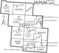
Adjacent counties
- Licking CountyLicking County, OhioLicking County is a county located in the state of Ohio, United States. As of the 2010 census, the population was 166,492. Its county seat is Newark and is named for the salt licks that were in the area....
(north) - Muskingum CountyMuskingum County, OhioMuskingum County is a county located in the state of Ohio, United States. As of the 2010 census, the population was 86,074. Its county seat is Zanesville...
(northeast) - Morgan CountyMorgan County, Ohio**----...
(southeast) - Athens CountyAthens County, OhioAs of the census of 2000, there were 62,223 people, 22,501 households, and 12,713 families residing in the county. The population density was 123 people per square mile . There were 24,901 housing units at an average density of 49 per square mile...
(south) - Hocking CountyHocking County, OhioHocking County is a county located in the state of Ohio, United States. As of 2010, the population was 29,380. Its county seat is Logan. Its name is from the Hocking River, the origins of which are disputed but is said to be a Delaware Indian word meaning "bottle river".-Geography:According to the...
(southwest) - Fairfield CountyFairfield County, OhioFairfield County is a county located in the state of Ohio, United States. As of 2010, the population was 146,156. Its county seat is Lancaster. Its name is a reference to the Fairfield area of the original Lancaster....
(west)
Demographics
As of the censusCensus
A census is the procedure of systematically acquiring and recording information about the members of a given population. It is a regularly occurring and official count of a particular population. The term is used mostly in connection with national population and housing censuses; other common...
of 2000, there were 34,078 people, 12,500 households, and 9,350 families residing in the county. The population density
Population density
Population density is a measurement of population per unit area or unit volume. It is frequently applied to living organisms, and particularly to humans...
was 83 people per square mile (32/km²). There were 13,655 housing units at an average density of 33 per square mile (13/km²). The racial makeup of the county was 98.54% White
Race (United States Census)
Race and ethnicity in the United States Census, as defined by the Federal Office of Management and Budget and the United States Census Bureau, are self-identification data items in which residents choose the race or races with which they most closely identify, and indicate whether or not they are...
, 0.22% Black
Race (United States Census)
Race and ethnicity in the United States Census, as defined by the Federal Office of Management and Budget and the United States Census Bureau, are self-identification data items in which residents choose the race or races with which they most closely identify, and indicate whether or not they are...
or African American
Race (United States Census)
Race and ethnicity in the United States Census, as defined by the Federal Office of Management and Budget and the United States Census Bureau, are self-identification data items in which residents choose the race or races with which they most closely identify, and indicate whether or not they are...
, 0.28% Native American
Race (United States Census)
Race and ethnicity in the United States Census, as defined by the Federal Office of Management and Budget and the United States Census Bureau, are self-identification data items in which residents choose the race or races with which they most closely identify, and indicate whether or not they are...
, 0.10% Asian
Race (United States Census)
Race and ethnicity in the United States Census, as defined by the Federal Office of Management and Budget and the United States Census Bureau, are self-identification data items in which residents choose the race or races with which they most closely identify, and indicate whether or not they are...
, 0.01% Pacific Islander
Race (United States Census)
Race and ethnicity in the United States Census, as defined by the Federal Office of Management and Budget and the United States Census Bureau, are self-identification data items in which residents choose the race or races with which they most closely identify, and indicate whether or not they are...
, 0.09% from other races
Race (United States Census)
Race and ethnicity in the United States Census, as defined by the Federal Office of Management and Budget and the United States Census Bureau, are self-identification data items in which residents choose the race or races with which they most closely identify, and indicate whether or not they are...
, and 0.76% from two or more races. 0.45% of the population were Hispanic
Race (United States Census)
Race and ethnicity in the United States Census, as defined by the Federal Office of Management and Budget and the United States Census Bureau, are self-identification data items in which residents choose the race or races with which they most closely identify, and indicate whether or not they are...
or Latino
Race (United States Census)
Race and ethnicity in the United States Census, as defined by the Federal Office of Management and Budget and the United States Census Bureau, are self-identification data items in which residents choose the race or races with which they most closely identify, and indicate whether or not they are...
of any race.
There were 12,500 households out of which 36.7% had children under the age of 18 living with them, 60.1% were married couples
Marriage
Marriage is a social union or legal contract between people that creates kinship. It is an institution in which interpersonal relationships, usually intimate and sexual, are acknowledged in a variety of ways, depending on the culture or subculture in which it is found...
living together, 9.8% had a female householder with no husband present, and 25.2% were non-families. 21.4% of all households were made up of individuals and 9.9% had someone living alone who was 65 years of age or older. The average household size was 2.70 and the average family size was 3.13.
In the county, the population was spread out with 28.1% under the age of 18, 8.5% from 18 to 24, 29.1% from 25 to 44, 22.3% from 45 to 64, and 12.0% who were 65 years of age or older. The median age was 35 years. For every 100 females there were 98.9 males. For every 100 females age 18 and over, there were 95.4 males.
The median income for a household in the county was $34,383, and the median income for a family was $40,294. Males had a median income of $31,664 versus $21,147 for females. The per capita income
Per capita income
Per capita income or income per person is a measure of mean income within an economic aggregate, such as a country or city. It is calculated by taking a measure of all sources of income in the aggregate and dividing it by the total population...
for the county was $15,674. About 9.4% of families and 11.8% of the population were below the poverty line, including 15.2% of those under age 18 and 12.70% of those age 65 or over.
Communities
Villages
|
Junction City, Ohio Junction City is a village in Perry County, Ohio, United States. The population was 818 at the 2000 census.-Geography:Junction City is located at .... New Lexington, Ohio New Lexington is a village in and the county seat of Perry County, Ohio, United States, southwest of Zanesville. The population was 4,689 at the 2000 census.In 1900, 1,701 people lived in New Lexington, Ohio; in 1910, 2,559 lived here.-Geography:... New Straitsville, Ohio New Straitsville is a village in Perry County, Ohio, United States. The population was 774 at the 2000 census.-History:New Straitsville was originally founded in 1870 as a coal mining town by the New Straitsville Mining Company. The town grew quickly and by 1880 the population was over 4000 people... Rendville, Ohio Rendville is a village in Perry County, Ohio, United States. The population was 46 at the 2000 census.-Geography:Rendville is located at , along Sunday Creek.... |
Roseville, Ohio Roseville is a village in Muskingum and Perry counties in the U.S. state of Ohio, along Moxahala Creek. The population was 1,936 at the 2000 census. Roseville is served by a branch of the Muskingum County Library System.-History:... Shawnee, Ohio Shawnee is a village in Perry County, Ohio, United States. The population was 608 at the 2000 census.-Geography:Shawnee is located at .According to the United States Census Bureau, the village has a total area of , all of it land.... Somerset, Ohio Somerset is a village in Perry County, Ohio, United States. The population was 1,549 at the 2000 census.Saint Joseph Church, the oldest Catholic church in Ohio, is located just outside of Somerset on State Route 383.-Geography:... Thornville, Ohio Thornville is a village in Perry County, Ohio, United States. The population was 731 at the 2000 census.-Geography:Thornville is located at .... |
Townships
|
Jackson Township, Perry County, Ohio Jackson Township is one of the fourteen townships of Perry County, Ohio, United States. The 2000 census found 2,791 people in the township, 1,973 of whom lived in the unincorporated portions of the township.-Geography:... Madison Township, Perry County, Ohio Madison Township is one of the fourteen townships of Perry County, Ohio, United States. The 2000 census found 1,229 people in the township.-Geography:Located in the northeastern corner of the county, it borders the following townships:... Monday Creek Township, Perry County, Ohio Monday Creek Township is one of the fourteen townships of Perry County, Ohio, United States. The 2000 census found 671 people in the township.-Geography:Located in the southwestern corner of the county, it borders the following townships:... Monroe Township, Perry County, Ohio Monroe Township is one of the fourteen townships of Perry County, Ohio, United States. The 2000 census found 1,565 people in the township, 926 of whom lived in the unincorporated portions of the township.-Geography:... Pike Township, Perry County, Ohio Pike Township is one of the fourteen townships of Perry County, Ohio, United States. The 2000 census found 6,595 people in the township, 1,906 of whom lived in the unincorporated portions of the township.-Geography:... |
Pleasant Township, Perry County, Ohio Pleasant Township is one of the fourteen townships of Perry County, Ohio, United States. The 2000 census found 794 people in the township.-Geography:Located in the southeastern part of the county, it borders the following townships:... Reading Township, Perry County, Ohio Reading Township is one of the fourteen townships of Perry County, Ohio, United States. The 2000 census found 3,956 people in the township, 2,407 of whom lived in the unincorporated portions of the township.-Geography:... Salt Lick Township, Perry County, Ohio Salt Lick Township is one of the fourteen townships of Perry County, Ohio, United States. The 2000 census found 1,200 people in the township, 450 of whom lived in the unincorporated portions of the township.-Geography:... Thorn Township, Perry County, Ohio Thorn Township is one of the fourteen townships of Perry County, Ohio, United States. The 2000 census found 3,765 people in the township, 3,034 of whom lived in the unincorporated portions of the township.-Geography:... |
Other communities
|
Moxahala, Ohio Moxahala is an unincorporated community in northern Pleasant Township, Perry County, Ohio, United States. Although it is unincorporated, it has a post office, with the ZIP code of 43761. State Route 13 runs through Moxahala, connecting it with New Lexington to the northwest and Rendville to the... Rehoboth, Ohio Rehoboth is an unincorporated community in southern Clayton Township, Perry County, Ohio, United States. Rehoboth is located along State Route 345 a short distance north of the county seat of New Lexington, and its ZIP code of 43764 is New Lexington's ZIP code.-External links:*... |