
Morrow County, Ohio
Encyclopedia
Morrow County is a county located in the state
of Ohio
, United States
. Shawnee
people used the area for hunting purposes before white settlers arrived in the early 19th century. Morrow County was organized in 1848 from parts of four neighboring counties and named for Jeremiah Morrow
, Governor of Ohio from 1822 to 1826. As of 2010, the population was 34,827. http://quickfacts.census.gov/qfd/states/39/39117.html and the census estimated the population to be 34,529 in 2006. Its county seat
is Mount Gilead
. The center of population
of Ohio is also located east of Mount Gilead. Morrow County is part of the Columbus, Ohio
Metropolitan Statistical Area.
Famous people born in Morrow County include (1) Warren G. Harding
, 29th President of the United States, who was born near Blooming Grove, Ohio
, in northeast Morrow County; (2) Quaker abolitionist Richard Dillingham
, who was born in Peru Township; (3) Reverend Frank W. Gunsaulus
, cleryman, writer and educator (see Illinois Institute of Technology
), who was born in Chesterville, Ohio
; and (4) writer Dawn Powell
, who was born in Mount Gilead.
Morrow County's historic World War I
Victory Shaft, unique in the United States
, is located in the center of downtown Mount Gilead. Other areas interesting to the tourist include: Mount Gilead State Park; Amish
farms and businesses near Johnsville and Chesterville; the Mid-Ohio Race Track near Steam Corners; the rolling Allegheny foothills
of eastern Morrow County; the site of the birthplace of President Warren G. Harding
near Blooming Grove; the site of the former Ohio Central College
in Iberia; the early 19th century architecture of buildings in Chesterville, Ohio
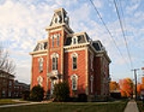
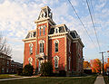
; the Revolutionary War Soldiers' Memorial in Mount Gilead; the Civil War monument in Cardington; and the mid-19th century architecture of the Morrow County Courthouse and Old Jail in Mount Gilead.
, the county has a total area of 407 square miles (1,054.1 km²).406 square miles (1,052 km²) of it is land and 1 square miles (2.6 km²) of it (0.28%) is water. Morrow County is considered to be a part of "Central Ohio."
of 2000, there were 31,628 people, 11,499 households, and 8,854 families residing in the county. The population density
was 78 people per square mile (30/km²). There were 12,132 housing units at an average density of 30 per square mile (12/km²). The racial makeup of the county was 98.37% White
, 0.27% Black
or African American
, 0.30% Native American
, 0.15% Asian
, 0.18% from other races
, and 0.74% from two or more races. 0.58% of the population were Hispanic
or Latino
of any race.
There were 11,499 households out of which 35.60% had children under the age of 18 living with them, 64.60% were married couples
living together, 8.10% had a female householder with no husband present, and 23.00% were non-families. 19.00% of all households were made up of individuals and 7.90% had someone living alone who was 65 years of age or older. The average household size was 2.72 and the average family size was 3.09.
 In the county, the population was spread out with 27.30% under the age of 18, 7.60% from 18 to 24, 29.30% from 25 to 44, 24.30% from 45 to 64, and 11.50% who were 65 years of age or older. The median age was 36 years. For every 100 females there were 99.40 males. For every 100 females age 18 and over, there were 98.00 males.
The median income for a household in the county was $40,882, and the median income for a family was $45,747. Males had a median income of $33,129 versus $22,454 for females. The per capita income
for the county was $17,830. About 6.60% of families and 9.00% of the population were below the poverty line, including 12.40% of those under age 18 and 7.10% of those age 65 or over.

U.S. state
A U.S. state is any one of the 50 federated states of the United States of America that share sovereignty with the federal government. Because of this shared sovereignty, an American is a citizen both of the federal entity and of his or her state of domicile. Four states use the official title of...
of Ohio
Ohio
Ohio is a Midwestern state in the United States. The 34th largest state by area in the U.S.,it is the 7th‑most populous with over 11.5 million residents, containing several major American cities and seven metropolitan areas with populations of 500,000 or more.The state's capital is Columbus...
, United States
United States
The United States of America is a federal constitutional republic comprising fifty states and a federal district...
. Shawnee
Shawnee
The Shawnee, Shaawanwaki, Shaawanooki and Shaawanowi lenaweeki, are an Algonquian-speaking people native to North America. Historically they inhabited the areas of Ohio, Virginia, West Virginia, Western Maryland, Kentucky, Indiana, and Pennsylvania...
people used the area for hunting purposes before white settlers arrived in the early 19th century. Morrow County was organized in 1848 from parts of four neighboring counties and named for Jeremiah Morrow
Jeremiah Morrow
Jeremiah Morrow was a Democratic-Republican Party politician from Ohio. He served as the ninth Governor of Ohio, and the last Democratic-Republican to do so....
, Governor of Ohio from 1822 to 1826. As of 2010, the population was 34,827. http://quickfacts.census.gov/qfd/states/39/39117.html and the census estimated the population to be 34,529 in 2006. Its county seat
County seat
A county seat is an administrative center, or seat of government, for a county or civil parish. The term is primarily used in the United States....
is Mount Gilead
Mount Gilead, Ohio
Mount Gilead is a village in Morrow County, Ohio, United States.Mount Gilead's population was 3,290 at the 2000 census. It is the county seat of Morrow County and the center of population of Ohio. The village was established in 1832, eight years after white settlers arrived in the region...
. The center of population
Center of population
In demographics, the center of population of a region is a geographical point that describes a centerpoint of the region's population...
of Ohio is also located east of Mount Gilead. Morrow County is part of the Columbus, Ohio
Columbus, Ohio
Columbus is the capital of and the largest city in the U.S. state of Ohio. The broader metropolitan area encompasses several counties and is the third largest in Ohio behind those of Cleveland and Cincinnati. Columbus is the third largest city in the American Midwest, and the fifteenth largest city...
Metropolitan Statistical Area.
Famous people born in Morrow County include (1) Warren G. Harding
Warren G. Harding
Warren Gamaliel Harding was the 29th President of the United States . A Republican from Ohio, Harding was an influential self-made newspaper publisher. He served in the Ohio Senate , as the 28th Lieutenant Governor of Ohio and as a U.S. Senator...
, 29th President of the United States, who was born near Blooming Grove, Ohio
Blooming Grove, Ohio
Blooming Grove is an unincorporated community in northeastern North Bloomfield Township, Morrow County, Ohio, United States. The community is located at the junction of State Route 97 and Morrow County Road 20. The nearest city is Galion, Ohio, located to the northwest...
, in northeast Morrow County; (2) Quaker abolitionist Richard Dillingham
Richard Dillingham
Richard Dillingham was a Quaker school teacher from Peru Township in what is now Morrow County, Ohio, U.S.A., who was arrested in Tennessee on December 5, 1848, while aiding the attempted escape of three slaves. Tried April 12, 1849, he was sentenced to three years in the Tennessee State...
, who was born in Peru Township; (3) Reverend Frank W. Gunsaulus
Frank W. Gunsaulus
Frank Wakeley Gunsaulus D.D. LL.D was a noted preacher, educator, pastor, author and humanitarian. Famous for his "Million Dollar Sermon" which led Philip Danforth Armour to donate money to found Armour Institute of Technology where Gunsaulus served as president for its first 27 years...
, cleryman, writer and educator (see Illinois Institute of Technology
Illinois Institute of Technology
Illinois Institute of Technology, commonly called Illinois Tech or IIT, is a private Ph.D.-granting university located in Chicago, Illinois, with programs in engineering, science, psychology, architecture, business, communications, industrial technology, information technology, design, and law...
), who was born in Chesterville, Ohio
Chesterville, Ohio
Chesterville is a village in Morrow County, Ohio, United States, along the Kokosing River. The population was 193 at the 2000 census. Chesterville is southeast of Mount Gilead, the county seat.-Geography:Chesterville is located at...
; and (4) writer Dawn Powell
Dawn Powell
Dawn Powell was an American writer of novels and stories.-Biography:Powell was born in Mount Gilead, Ohio, a village 45 miles north of Columbus and the county seat of Morrow County. Powell regularly gave her birth year as 1897 but primary documents support the earlier date...
, who was born in Mount Gilead.
Morrow County's historic World War I
World War I
World War I , which was predominantly called the World War or the Great War from its occurrence until 1939, and the First World War or World War I thereafter, was a major war centred in Europe that began on 28 July 1914 and lasted until 11 November 1918...
Victory Shaft, unique in the United States
United States
The United States of America is a federal constitutional republic comprising fifty states and a federal district...
, is located in the center of downtown Mount Gilead. Other areas interesting to the tourist include: Mount Gilead State Park; Amish
Amish
The Amish , sometimes referred to as Amish Mennonites, are a group of Christian church fellowships that form a subgroup of the Mennonite churches...
farms and businesses near Johnsville and Chesterville; the Mid-Ohio Race Track near Steam Corners; the rolling Allegheny foothills
Allegheny Mountains
The Allegheny Mountain Range , also spelled Alleghany, Allegany and, informally, the Alleghenies, is part of the vast Appalachian Mountain Range of the eastern United States and Canada...
of eastern Morrow County; the site of the birthplace of President Warren G. Harding
Warren G. Harding
Warren Gamaliel Harding was the 29th President of the United States . A Republican from Ohio, Harding was an influential self-made newspaper publisher. He served in the Ohio Senate , as the 28th Lieutenant Governor of Ohio and as a U.S. Senator...
near Blooming Grove; the site of the former Ohio Central College
Ohio Central College
Ohio Central College was a college located in Iberia, Ohio in northwestern Morrow County, Ohio during the second half of the 19th Century. Open to both genders and all races, the college was founded by the Presbyterian Church and led by the Rev. George Gordon, a strong abolitionist. It counts...
in Iberia; the early 19th century architecture of buildings in Chesterville, Ohio
Chesterville, Ohio
Chesterville is a village in Morrow County, Ohio, United States, along the Kokosing River. The population was 193 at the 2000 census. Chesterville is southeast of Mount Gilead, the county seat.-Geography:Chesterville is located at...
; the Revolutionary War Soldiers' Memorial in Mount Gilead; the Civil War monument in Cardington; and the mid-19th century architecture of the Morrow County Courthouse and Old Jail in Mount Gilead.
Geography
According to the U.S. Census BureauUnited States Census Bureau
The United States Census Bureau is the government agency that is responsible for the United States Census. It also gathers other national demographic and economic data...
, the county has a total area of 407 square miles (1,054.1 km²).406 square miles (1,052 km²) of it is land and 1 square miles (2.6 km²) of it (0.28%) is water. Morrow County is considered to be a part of "Central Ohio."
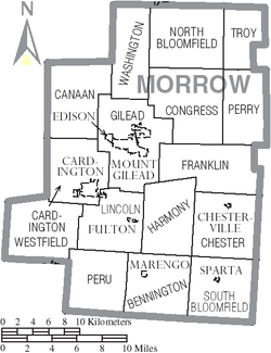
Adjacent counties
- Crawford CountyCrawford County, OhioCrawford County is a county located in the state of Ohio, United States. It was named for Colonel William Crawford, a soldier during the American Revolution....
(north) - Richland CountyRichland County, OhioRichland County is a county located in the state of Ohio, United States. As of the 2010 census, the population was 124,475. It is included in the Mansfield, Ohio, Metropolitan Statistical Area as well as the Mansfield–Bucyrus Combined Statistical Area....
(northeast) - Knox CountyKnox County, OhioKnox County is a county located in the state of Ohio, United States. As of 2010, the population was 60,921. Its county seat is Mount Vernon and is named for Henry Knox, an officer in the American Revolutionary War who was later the first Secretary of War....
(southeast) - Delaware CountyDelaware County, OhioDelaware County is a fast-growing suburban county in the state of Ohio, United States, within the Columbus, Ohio Metropolitan Statistical Area. According to the United States Census Bureau's 2004 population estimates, Delaware County's population of 142,503 made it the fastest growing county in...
(southwest) - Marion CountyMarion County, OhioMarion County is a county located in the state of Ohio, United States. As of the 2010 census, the population was 66,501. Its county seat is the city of Marion and is named for General Francis "The Swamp Fox" Marion, an officer in the Revolutionary War....
(west)
Demographics
As of the censusCensus
A census is the procedure of systematically acquiring and recording information about the members of a given population. It is a regularly occurring and official count of a particular population. The term is used mostly in connection with national population and housing censuses; other common...
of 2000, there were 31,628 people, 11,499 households, and 8,854 families residing in the county. The population density
Population density
Population density is a measurement of population per unit area or unit volume. It is frequently applied to living organisms, and particularly to humans...
was 78 people per square mile (30/km²). There were 12,132 housing units at an average density of 30 per square mile (12/km²). The racial makeup of the county was 98.37% White
Race (United States Census)
Race and ethnicity in the United States Census, as defined by the Federal Office of Management and Budget and the United States Census Bureau, are self-identification data items in which residents choose the race or races with which they most closely identify, and indicate whether or not they are...
, 0.27% Black
Race (United States Census)
Race and ethnicity in the United States Census, as defined by the Federal Office of Management and Budget and the United States Census Bureau, are self-identification data items in which residents choose the race or races with which they most closely identify, and indicate whether or not they are...
or African American
Race (United States Census)
Race and ethnicity in the United States Census, as defined by the Federal Office of Management and Budget and the United States Census Bureau, are self-identification data items in which residents choose the race or races with which they most closely identify, and indicate whether or not they are...
, 0.30% Native American
Race (United States Census)
Race and ethnicity in the United States Census, as defined by the Federal Office of Management and Budget and the United States Census Bureau, are self-identification data items in which residents choose the race or races with which they most closely identify, and indicate whether or not they are...
, 0.15% Asian
Race (United States Census)
Race and ethnicity in the United States Census, as defined by the Federal Office of Management and Budget and the United States Census Bureau, are self-identification data items in which residents choose the race or races with which they most closely identify, and indicate whether or not they are...
, 0.18% from other races
Race (United States Census)
Race and ethnicity in the United States Census, as defined by the Federal Office of Management and Budget and the United States Census Bureau, are self-identification data items in which residents choose the race or races with which they most closely identify, and indicate whether or not they are...
, and 0.74% from two or more races. 0.58% of the population were Hispanic
Race (United States Census)
Race and ethnicity in the United States Census, as defined by the Federal Office of Management and Budget and the United States Census Bureau, are self-identification data items in which residents choose the race or races with which they most closely identify, and indicate whether or not they are...
or Latino
Race (United States Census)
Race and ethnicity in the United States Census, as defined by the Federal Office of Management and Budget and the United States Census Bureau, are self-identification data items in which residents choose the race or races with which they most closely identify, and indicate whether or not they are...
of any race.
There were 11,499 households out of which 35.60% had children under the age of 18 living with them, 64.60% were married couples
Marriage
Marriage is a social union or legal contract between people that creates kinship. It is an institution in which interpersonal relationships, usually intimate and sexual, are acknowledged in a variety of ways, depending on the culture or subculture in which it is found...
living together, 8.10% had a female householder with no husband present, and 23.00% were non-families. 19.00% of all households were made up of individuals and 7.90% had someone living alone who was 65 years of age or older. The average household size was 2.72 and the average family size was 3.09.
The median income for a household in the county was $40,882, and the median income for a family was $45,747. Males had a median income of $33,129 versus $22,454 for females. The per capita income
Per capita income
Per capita income or income per person is a measure of mean income within an economic aggregate, such as a country or city. It is calculated by taking a measure of all sources of income in the aggregate and dividing it by the total population...
for the county was $17,830. About 6.60% of families and 9.00% of the population were below the poverty line, including 12.40% of those under age 18 and 7.10% of those age 65 or over.
Government
Communities
Villages
|
Marengo, Ohio Marengo is a village in Morrow County, Ohio, United States. The population was 297 at the 2000 census. Marengo is south of Mount Gilead, the county seat.-Geography:Marengo is located at... Mount Gilead, Ohio Mount Gilead is a village in Morrow County, Ohio, United States.Mount Gilead's population was 3,290 at the 2000 census. It is the county seat of Morrow County and the center of population of Ohio. The village was established in 1832, eight years after white settlers arrived in the region... Sparta, Ohio Sparta is a village in Morrow County, Ohio, United States. The population was 191 at the 2000 census. Sparta is southeast of Mount Gilead, Ohio, the county seat.-Geography:Sparta is located at... |
Townships
|
Congress Township, Morrow County, Ohio Congress Township is one of the sixteen townships of Morrow County, Ohio, United States. The 2000 census found 2,128 people in the township.-Geography:Located in the northern part of the county, it borders the following townships:... Franklin Township, Morrow County, Ohio Franklin Township is one of the sixteen townships of Morrow County, Ohio, United States. The 2000 census found 1,410 people in the township.-Geography:Located in the eastern part of the county, it borders the following townships:*Congress Township - north... Gilead Township, Morrow County, Ohio Gilead Township is one of the sixteen townships of Morrow County, Ohio, United States. The 2000 census found 5,868 people in the township, 2,141 of whom lived in the unincorporated portions of the township.-Geography:... Harmony Township, Morrow County, Ohio Harmony Township is one of the sixteen townships of Morrow County, Ohio, United States. The 2000 census found 2,040 people in the township.-Geography:Located in the central part of the county, it borders the following townships:... |
Lincoln Township, Morrow County, Ohio Lincoln Township is one of the sixteen townships of Morrow County, Ohio, United States. The 2000 census found 1,955 people in the township, 1,672 of whom lived in the unincorporated portions of the township.-Geography:... North Bloomfield Township, Morrow County, Ohio North Bloomfield Township is one of the sixteen townships of Morrow County, Ohio, United States. The 2000 census found 1,866 people in the township.-Geography:Located in the northern part of the county, it borders the following townships:... Perry Township, Morrow County, Ohio Perry Township is one of the sixteen townships of Morrow County, Ohio, United States. The 2000 census found 1,970 people in the township.-Geography:Located in the eastern part of the county, it borders the following townships:*Troy Township - north... Peru Township, Morrow County, Ohio Peru Township is one of the sixteen townships of Morrow County, Ohio, United States. The 2000 census found 1,260 people in the township.-Geography:Located in the southwestern part of the county, it borders the following townships:*Lincoln Township - north... |
South Bloomfield Township, Morrow County, Ohio South Bloomfield Township is one of the sixteen townships of Morrow County, Ohio, United States. The 2000 census found 1,609 people in the township, 1,418 of whom lived in the unincorporated portions of the township.-Geography:... Troy Township, Morrow County, Ohio Troy Township is one of the sixteen townships of Morrow County, Ohio, United States. The 2000 census found 1,190 people in the township.-Geography:Located in the northeastern corner of the county, it borders the following townships:... Washington Township, Morrow County, Ohio Washington Township is one of the sixteen townships of Morrow County, Ohio, United States. The 2000 census found 1,227 people in the township.-Geography:Located in the northwestern corner of the county, it borders the following townships:... Westfield Township, Morrow County, Ohio Westfield Township is one of the sixteen townships of Morrow County, Ohio, United States. The 2000 census found 1,100 people in the township.-Geography:Located in the southwestern corner of the county, it borders the following townships:... |
Unincorporated communities
|
Shauck, Ohio Shauck is an unincorporated community in northern Perry Township, Morrow County, Ohio, United States. Although it is unincorporated, it has a post office, with the ZIP code of 43349. It is located at the intersection of U.S. Route 42 with State Route 314. Shauck is also known as... |
|