
Knox County, Ohio
Encyclopedia
Knox County is a county located in the state
of Ohio
, United States
. As of 2010, the population was 60,921. http://quickfacts.census.gov/qfd/states/39/39083.html Its county seat
is Mount Vernon
and is named for Henry Knox
, an officer in the American Revolutionary War
who was later the first Secretary of War
.
The Mount Vernon Micropolitan Statistical Area includes all of Knox County.
, the county has a total area of 530 square miles (1,372.7 km²).527 square miles (1,364.9 km²) is land and 2 square miles (5.2 km²) (0.46%) is water. Most of the county lies in the Glaciated Allegheny Plateau with rolling hills and valleys. Although the relief is not sharp, some elevations in the county reach over 1400 feet above sea level.
of 2000, there were 54,500 people, 19,975 households, and 14,362 families residing in the county. The population density
was 103 people per square mile (40/km²). There were 21,793 housing units at an average density of 41 per square mile (16/km²). The racial makeup of the county was 97.66% White
, 0.67% Black
or African American
, 0.21% Native American
, 0.34% Asian
, 0.02% Pacific Islander
, 0.21% from other races
, and 0.89% from two or more races. 0.68% of the population were Hispanic
or Latino
of any race. 95.6% spoke English
, 1.3% German
and 1.1% Spanish
as their first language.
There were 19,975 households out of which 32.50% had children under the age of 18 living with them, 59.60% were married couples
living together, 8.50% had a female householder with no husband present, and 28.10% were non-families. 23.90% of all households were made up of individuals and 10.60% had someone living alone who was 65 years of age or older. The average household size was 2.56 and the average family size was 3.03.
In the county, the population was spread out with 24.80% under the age of 18, 11.70% from 18 to 24, 26.70% from 25 to 44, 23.00% from 45 to 64, and 13.80% who were 65 years of age or older. The median age was 36 years. For every 100 females there were 94.70 males. For every 100 females age 18 and over, there were 90.90 males.
The median income for a household in the county was $38,877, and the median income for a family was $45,119. Males had a median income of $34,363 versus $24,352 for females. The per capita income
for the county was $17,695. About 7.40% of families and 10.10% of the population were below the poverty line, including 13.60% of those under age 18 and 7.60% of those age 65 or over.

U.S. state
A U.S. state is any one of the 50 federated states of the United States of America that share sovereignty with the federal government. Because of this shared sovereignty, an American is a citizen both of the federal entity and of his or her state of domicile. Four states use the official title of...
of Ohio
Ohio
Ohio is a Midwestern state in the United States. The 34th largest state by area in the U.S.,it is the 7th‑most populous with over 11.5 million residents, containing several major American cities and seven metropolitan areas with populations of 500,000 or more.The state's capital is Columbus...
, United States
United States
The United States of America is a federal constitutional republic comprising fifty states and a federal district...
. As of 2010, the population was 60,921. http://quickfacts.census.gov/qfd/states/39/39083.html Its county seat
County seat
A county seat is an administrative center, or seat of government, for a county or civil parish. The term is primarily used in the United States....
is Mount Vernon
Mount Vernon, Ohio
Mount Vernon is a city in Knox County, Ohio, United States. The population was 16,990 at the 2010 census. It is the county seat of Knox County. The city is named after Mount Vernon, the plantation owned by George Washington.-History:...
and is named for Henry Knox
Henry Knox
Henry Knox was a military officer of the Continental Army and later the United States Army, and also served as the first United States Secretary of War....
, an officer in the American Revolutionary War
American Revolutionary War
The American Revolutionary War , the American War of Independence, or simply the Revolutionary War, began as a war between the Kingdom of Great Britain and thirteen British colonies in North America, and ended in a global war between several European great powers.The war was the result of the...
who was later the first Secretary of War
United States Secretary of War
The Secretary of War was a member of the United States President's Cabinet, beginning with George Washington's administration. A similar position, called either "Secretary at War" or "Secretary of War," was appointed to serve the Congress of the Confederation under the Articles of Confederation...
.
The Mount Vernon Micropolitan Statistical Area includes all of Knox County.
Geography
According to the U.S. Census BureauUnited States Census Bureau
The United States Census Bureau is the government agency that is responsible for the United States Census. It also gathers other national demographic and economic data...
, the county has a total area of 530 square miles (1,372.7 km²).527 square miles (1,364.9 km²) is land and 2 square miles (5.2 km²) (0.46%) is water. Most of the county lies in the Glaciated Allegheny Plateau with rolling hills and valleys. Although the relief is not sharp, some elevations in the county reach over 1400 feet above sea level.
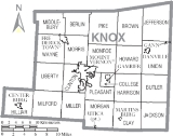
Adjacent counties
- Richland CountyRichland County, OhioRichland County is a county located in the state of Ohio, United States. As of the 2010 census, the population was 124,475. It is included in the Mansfield, Ohio, Metropolitan Statistical Area as well as the Mansfield–Bucyrus Combined Statistical Area....
(north) - Ashland CountyAshland County, OhioAshland County is a county located in the state of Ohio, United States, and was formed in 1846 from parts of Huron, Lorain, Richland and Wayne Counties. As of the 2010 census, the population was 53,139. Its county seat is Ashland...
(far northeast) - Holmes CountyHolmes County, OhioAs of the census of 2000, there were 38,943 people, 11,337 households, and 9,194 families residing in the county. The population density was 92 people per square mile . There were 12,280 housing units at an average density of 29 per square mile...
(northeast) - Coshocton CountyCoshocton County, OhioCoshocton County is a county located in the state of Ohio, United States. As of the 2010 census, the population was 36,901. Its county seat is Coshocton. Its name comes from the Delaware Indian language and has been translated as "union of waters" or "black bear crossing".The Coshocton...
(east) - Licking CountyLicking County, OhioLicking County is a county located in the state of Ohio, United States. As of the 2010 census, the population was 166,492. Its county seat is Newark and is named for the salt licks that were in the area....
(south) - Delaware CountyDelaware County, OhioDelaware County is a fast-growing suburban county in the state of Ohio, United States, within the Columbus, Ohio Metropolitan Statistical Area. According to the United States Census Bureau's 2004 population estimates, Delaware County's population of 142,503 made it the fastest growing county in...
(southwest) - Morrow CountyMorrow County, OhioMorrow County is a county located in the state of Ohio, United States. Shawnee people used the area for hunting purposes before white settlers arrived in the early 19th century. Morrow County was organized in 1848 from parts of four neighboring counties and named for Jeremiah Morrow, Governor of...
(northwest)
Demographics
As of the censusCensus
A census is the procedure of systematically acquiring and recording information about the members of a given population. It is a regularly occurring and official count of a particular population. The term is used mostly in connection with national population and housing censuses; other common...
of 2000, there were 54,500 people, 19,975 households, and 14,362 families residing in the county. The population density
Population density
Population density is a measurement of population per unit area or unit volume. It is frequently applied to living organisms, and particularly to humans...
was 103 people per square mile (40/km²). There were 21,793 housing units at an average density of 41 per square mile (16/km²). The racial makeup of the county was 97.66% White
Race (United States Census)
Race and ethnicity in the United States Census, as defined by the Federal Office of Management and Budget and the United States Census Bureau, are self-identification data items in which residents choose the race or races with which they most closely identify, and indicate whether or not they are...
, 0.67% Black
Race (United States Census)
Race and ethnicity in the United States Census, as defined by the Federal Office of Management and Budget and the United States Census Bureau, are self-identification data items in which residents choose the race or races with which they most closely identify, and indicate whether or not they are...
or African American
Race (United States Census)
Race and ethnicity in the United States Census, as defined by the Federal Office of Management and Budget and the United States Census Bureau, are self-identification data items in which residents choose the race or races with which they most closely identify, and indicate whether or not they are...
, 0.21% Native American
Race (United States Census)
Race and ethnicity in the United States Census, as defined by the Federal Office of Management and Budget and the United States Census Bureau, are self-identification data items in which residents choose the race or races with which they most closely identify, and indicate whether or not they are...
, 0.34% Asian
Race (United States Census)
Race and ethnicity in the United States Census, as defined by the Federal Office of Management and Budget and the United States Census Bureau, are self-identification data items in which residents choose the race or races with which they most closely identify, and indicate whether or not they are...
, 0.02% Pacific Islander
Race (United States Census)
Race and ethnicity in the United States Census, as defined by the Federal Office of Management and Budget and the United States Census Bureau, are self-identification data items in which residents choose the race or races with which they most closely identify, and indicate whether or not they are...
, 0.21% from other races
Race (United States Census)
Race and ethnicity in the United States Census, as defined by the Federal Office of Management and Budget and the United States Census Bureau, are self-identification data items in which residents choose the race or races with which they most closely identify, and indicate whether or not they are...
, and 0.89% from two or more races. 0.68% of the population were Hispanic
Race (United States Census)
Race and ethnicity in the United States Census, as defined by the Federal Office of Management and Budget and the United States Census Bureau, are self-identification data items in which residents choose the race or races with which they most closely identify, and indicate whether or not they are...
or Latino
Race (United States Census)
Race and ethnicity in the United States Census, as defined by the Federal Office of Management and Budget and the United States Census Bureau, are self-identification data items in which residents choose the race or races with which they most closely identify, and indicate whether or not they are...
of any race. 95.6% spoke English
English language
English is a West Germanic language that arose in the Anglo-Saxon kingdoms of England and spread into what was to become south-east Scotland under the influence of the Anglian medieval kingdom of Northumbria...
, 1.3% German
German language
German is a West Germanic language, related to and classified alongside English and Dutch. With an estimated 90 – 98 million native speakers, German is one of the world's major languages and is the most widely-spoken first language in the European Union....
and 1.1% Spanish
Spanish language
Spanish , also known as Castilian , is a Romance language in the Ibero-Romance group that evolved from several languages and dialects in central-northern Iberia around the 9th century and gradually spread with the expansion of the Kingdom of Castile into central and southern Iberia during the...
as their first language.
There were 19,975 households out of which 32.50% had children under the age of 18 living with them, 59.60% were married couples
Marriage
Marriage is a social union or legal contract between people that creates kinship. It is an institution in which interpersonal relationships, usually intimate and sexual, are acknowledged in a variety of ways, depending on the culture or subculture in which it is found...
living together, 8.50% had a female householder with no husband present, and 28.10% were non-families. 23.90% of all households were made up of individuals and 10.60% had someone living alone who was 65 years of age or older. The average household size was 2.56 and the average family size was 3.03.
In the county, the population was spread out with 24.80% under the age of 18, 11.70% from 18 to 24, 26.70% from 25 to 44, 23.00% from 45 to 64, and 13.80% who were 65 years of age or older. The median age was 36 years. For every 100 females there were 94.70 males. For every 100 females age 18 and over, there were 90.90 males.
The median income for a household in the county was $38,877, and the median income for a family was $45,119. Males had a median income of $34,363 versus $24,352 for females. The per capita income
Per capita income
Per capita income or income per person is a measure of mean income within an economic aggregate, such as a country or city. It is calculated by taking a measure of all sources of income in the aggregate and dividing it by the total population...
for the county was $17,695. About 7.40% of families and 10.10% of the population were below the poverty line, including 13.60% of those under age 18 and 7.60% of those age 65 or over.
Government
Roster of County Officials:- Commissioners: Teresa Bemiller, Allen Stockberger, Bob Wise
- Prosecutor: John C. Thatcher
- Sheriff: David B. Barber
- Auditor: Jonette Curry
- Treasurer: Sandra Mizer
- Recorder: John Lybarger
- Clerk of Courts: Mary Jo Hawkins
- Engineer: Jim Henry
- Judge, Common Pleas Court: Otho Eyster
- Judge, Juvenile/Probate: James M. Ronk
Communities
Villages
|
Fredericktown, Ohio Fredericktown is a village in Knox County, Ohio, United States. The population was 2,428 at the 2000 census.-History:Long before white settlers entered the area, Adena and Hopewell Indians inhabited the area of Fredericktown. Early settlers found three mounds and earthworks located on nearby hilltops... Gambier, Ohio Gambier is a village in Knox County, Ohio, United States. The population was 1,871 at the 2000 census.Gambier is the home of Kenyon College and was named after one of Kenyon College's early benefactors, Lord Gambier.... |
Gann, Ohio Gann, also known as Brinkhaven, is a village in Knox County, Ohio, United States. The population was 143 at the 2000 census.-Geography:Gann is located at , along the Mohican River.... Martinsburg, Ohio Martinsburg is a village in Knox County, Ohio, United States. The population was 185 at the 2000 census.-Geography:Martinsburg is located at .... |
Utica, Ohio Utica is a village in Knox and Licking counties in the U.S. state of Ohio, along the North Fork of the Licking River. The population was 2,130 at the 2000 census.... |
Townships
|
College Township, Knox County, Ohio College Township is one of the twenty-two townships of Knox County, Ohio, United States. The 2000 census found 2,247 people in the township, 376 of whom lived in the unincorporated portions of the township.-Geography:... Harrison Township, Knox County, Ohio Harrison Township is one of the twenty-two townships of Knox County, Ohio, United States. The 2000 census found 747 people in the township.-Geography:Located in the east central part of the county, it borders the following townships:... Hilliar Township, Knox County, Ohio Hilliar Township is one of the twenty-two townships of Knox County, Ohio, United States. The 2000 census found 3,080 people in the township, 1,648 of whom lived in the unincorporated portions of the township.-Geography:... Howard Township, Knox County, Ohio Howard Township is one of the twenty-two townships of Knox County, Ohio, United States. The 2000 census found 4,319 people in the township.-Geography:Located in the east central part of the county, it borders the following townships:*Brown Township - north... Jackson Township, Knox County, Ohio Jackson Township is one of the twenty-two townships of Knox County, Ohio, United States. The 2000 census found 878 people in the township.-Geography:Located in the southeastern corner of the county, it borders the following townships:... |
Jefferson Township, Knox County, Ohio Jefferson Township is one of the twenty-two townships of Knox County, Ohio, United States. The 2000 census found 604 people in the township.-Geography:Located in the northeastern corner of the county, it borders the following townships:... Liberty Township, Knox County, Ohio Liberty Township is one of the twenty-two townships of Knox County, Ohio, United States. The 2000 census found 1,422 people in the township.-Geography:Located in the western part of the county, it borders the following townships:*Wayne Township - north... Middlebury Township, Knox County, Ohio Middlebury Township is one of the twenty-two townships of Knox County, Ohio, United States. The 2000 census found 1,138 people in the township.-Geography:Located in the northwestern corner of the county, it borders the following townships:... Milford Township, Knox County, Ohio Milford Township is one of the twenty-two townships of Knox County, Ohio, United States. The 2000 census found 1,422 people in the township.-Geography:Located in the southwestern part of the county, it borders the following townships:... |
Miller Township, Knox County, Ohio Miller Township is one of the twenty-two townships of Knox County, Ohio, United States. The 2000 census found 893 people in the township.-Geography:Located in the southern part of the county, it borders the following townships:*Clinton Township - north... Monroe Township, Knox County, Ohio Monroe Township is one of the twenty-two townships of Knox County, Ohio, United States. The 2000 census found 2,427 people in the township.-Geography:Located in the center of the county, it borders the following townships:*Pike Township - north... Morgan Township, Knox County, Ohio Morgan Township is one of the twenty-two townships of Knox County, Ohio, United States. The 2000 census found 843 people in the township, 841 of whom lived in the unincorporated portions of the township.-Geography:... Morris Township, Knox County, Ohio Morris Township is one of the twenty-two townships of Knox County, Ohio, United States. The 2000 census found 1,998 people in the township.-Geography:Located in the west central part of the county, it borders the following townships:... |
Pike Township, Knox County, Ohio Pike Township is one of the twenty-two townships of Knox County, Ohio, United States. The 2000 census found 1,298 people in the township.-Geography:Located in the northern part of the county, it borders the following townships:... Pleasant Township, Knox County, Ohio Pleasant Township is one of the twenty-two townships of Knox County, Ohio, United States. The 2000 census found 2,362 people in the township.-Geography:Located in the center of the county, it borders the following townships:*Monroe Township - north... Union Township, Knox County, Ohio Union Township is one of the twenty-two townships of Knox County, Ohio, United States. The 2000 census found 2,455 people in the township, 1,208 of whom lived in the unincorporated portions of the township.-Geography:... Wayne Township, Knox County, Ohio Wayne Township is one of the twenty-two townships of Knox County, Ohio, United States. The 2000 census found 898 people in the township.-Geography:Located in the western part of the county, it borders the following townships:*Middlebury Township - north... |
Unincorporated communities
|
Howard, Ohio Howard is a census-designated place in southern Howard Township, Knox County, Ohio, United States. It is located at . The United States Postal Service has assigned Howard the ZIP Code 43028.... Mount Liberty, Ohio Mount Liberty is an unincorporated community on the border between the Milford and Liberty Townships of Knox County, Ohio, United States. Although it is unincorporated, it has a post office, with the ZIP code of 43048. It lies along the concurrent U.S... |
Notable residents
- Thomas Peter AkersThomas Peter AkersThomas Peter Akers was an attorney, college professor, and member of the United States House of Representatives from 1856 to 1857. He was born in Knox County, Ohio, where he graduated from college and studied law....
, United States Congressman - Paul LyndePaul LyndePaul Edward Lynde was an American comedian and actor. A noted character actor, Lynde was well known for his roles as Uncle Arthur on Bewitched and Harry MacAfee, the befuddled father in Bye Bye Birdie...
, actor - Dan EmmettDan EmmettDaniel Decatur "Dan" Emmett was an American songwriter and entertainer, founder of the first troupe of the blackface minstrel tradition.-Biography:...
, author of Dixie - Luke PerryLuke PerryLuke Perry is an American actor. Perry starred as Dylan McKay on the TV series Beverly Hills, 90210, a role he played from 1990–95, and then from 1998–2000. Much publicity was garnered over the fact that even though he was playing a sixteen-year-old when 90210 began, Perry was actually in his...
, actor in the 90's teen drama series Beverly Hills, 90210