
Columbiana County, Ohio
Encyclopedia
Columbiana County is a county located in the U.S. state
of Ohio
. As of 2010, the population was 107,841. http://quickfacts.census.gov/qfd/states/39/39029.html It is named for Christopher Columbus
and the county seat
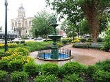
is Lisbon
.
The East Liverpool
–Salem
Micropolitan Statistical Area includes all of Columbiana County.
tribes in the area were the Wyandots, Mingoes, and Delawares. Throughout the second half of the 18th century white explorers, starting with Christopher Gist
in 1750, came to the area. George Washington
, while engaged in land examinations, camped in the area of present-day East Liverpool in 1774.
Columbiana County was founded in 1803 and named in honor of Christopher Columbus
. It was the scene of one of the northern-most action fought during the American Civil War
; in July 1863 Confederate
raiders under John Morgan
were surrounded and captured by Union forces
.
, the county has a total area of 535 square miles (1,385.6 km²).532 square miles (1,377.9 km²) is land and 3 square miles (7.8 km²) (0.51%) is water.
of 2000, there were 112,075 people, 42,973 households, and 30,682 families residing in the county. The population density
was 210 people per square mile (81/km²). There were 46,083 housing units at an average density of 86 per square mile (33/km²). The racial makeup of the county was 96.43% White
, 2.20% Black
or African American
, 0.18% Native American
, 0.23% Asian
, 0.02% Pacific Islander
, 0.15% from other races
, and 0.79% from two or more races. 1.17% of the population were Hispanic
or Latino
of any race. 24.0% were of German
, 12.9% English
, 12.8% American
, 12.3% Irish
and 9.3% Italian ancestry according to Census 2000.
There were 42,973 households out of which 31.70% had children under the age of 18 living with them, 57.10% were married couples
living together, 10.30% had a female householder with no husband present, and 28.60% were non-families. 24.80% of all households were made up of individuals and 11.90% had someone living alone who was 65 years of age or older. The average household size was 2.52 and the average family size was 3.00.
In the county the population was spread out with 24.30% under the age of 18, 7.80% from 18 to 24, 28.60% from 25 to 44, 24.20% from 45 to 64, and 15.00% who were 65 years of age or older. The median age was 38 years. For every 100 females there were 98.80 males. For every 100 females age 18 and over, there were 96.60 males.
The median income for a household in the county was $34,226, and the median income for a family was $40,486. Males had a median income of $32,134 versus $20,331 for females. The per capita income
for the county was $16,655. About 9.00% of families and 11.50% of the population were below the poverty line, including 16.20% of those under age 18 and 8.40% of those age 65 or over.
) as defined by United States Census Bureau
. Census Bureau Statistical areas indicate an area with noteworthy economic or employment interactions.

U.S. state
A U.S. state is any one of the 50 federated states of the United States of America that share sovereignty with the federal government. Because of this shared sovereignty, an American is a citizen both of the federal entity and of his or her state of domicile. Four states use the official title of...
of Ohio
Ohio
Ohio is a Midwestern state in the United States. The 34th largest state by area in the U.S.,it is the 7th‑most populous with over 11.5 million residents, containing several major American cities and seven metropolitan areas with populations of 500,000 or more.The state's capital is Columbus...
. As of 2010, the population was 107,841. http://quickfacts.census.gov/qfd/states/39/39029.html It is named for Christopher Columbus
Christopher Columbus
Christopher Columbus was an explorer, colonizer, and navigator, born in the Republic of Genoa, in northwestern Italy. Under the auspices of the Catholic Monarchs of Spain, he completed four voyages across the Atlantic Ocean that led to general European awareness of the American continents in the...
and the county seat
County seat
A county seat is an administrative center, or seat of government, for a county or civil parish. The term is primarily used in the United States....
is Lisbon
Lisbon, Ohio
Lisbon is a village in Center Township, Columbiana County, Ohio, United States. The population was 2,788 at the 2000 census. It is the county seat of Columbiana County.-History:...
.
The East Liverpool
East Liverpool, Ohio
As of the census of 2000, there were 13,089 people, 5,261 households, and 3,424 families residing in the city. The population density was 3,010.3 people per square mile . There were 5,743 housing units at an average density of 1,320.8 per square mile...
–Salem
Salem, Ohio
Salem is a city in northern Columbiana County and extreme southern Mahoning County, Ohio, United States. At the 2000 census, the city's population was 12,197....
Micropolitan Statistical Area includes all of Columbiana County.
History
The principal historic IndianIndigenous peoples of the Americas
The indigenous peoples of the Americas are the pre-Columbian inhabitants of North and South America, their descendants and other ethnic groups who are identified with those peoples. Indigenous peoples are known in Canada as Aboriginal peoples, and in the United States as Native Americans...
tribes in the area were the Wyandots, Mingoes, and Delawares. Throughout the second half of the 18th century white explorers, starting with Christopher Gist
Christopher Gist
Christopher Gist was an accomplished American explorer, surveyor and frontiersman. He was one of the first white explorers of the Ohio Country . He is credited with providing the first detailed description of the Ohio Country to Great Britain and her colonists...
in 1750, came to the area. George Washington
George Washington
George Washington was the dominant military and political leader of the new United States of America from 1775 to 1799. He led the American victory over Great Britain in the American Revolutionary War as commander-in-chief of the Continental Army from 1775 to 1783, and presided over the writing of...
, while engaged in land examinations, camped in the area of present-day East Liverpool in 1774.
Columbiana County was founded in 1803 and named in honor of Christopher Columbus
Christopher Columbus
Christopher Columbus was an explorer, colonizer, and navigator, born in the Republic of Genoa, in northwestern Italy. Under the auspices of the Catholic Monarchs of Spain, he completed four voyages across the Atlantic Ocean that led to general European awareness of the American continents in the...
. It was the scene of one of the northern-most action fought during the American Civil War
American Civil War
The American Civil War was a civil war fought in the United States of America. In response to the election of Abraham Lincoln as President of the United States, 11 southern slave states declared their secession from the United States and formed the Confederate States of America ; the other 25...
; in July 1863 Confederate
Confederate States of America
The Confederate States of America was a government set up from 1861 to 1865 by 11 Southern slave states of the United States of America that had declared their secession from the U.S...
raiders under John Morgan
John Hunt Morgan
John Hunt Morgan was a Confederate general and cavalry officer in the American Civil War.Morgan is best known for Morgan's Raid when, in 1863, he and his men rode over 1,000 miles covering a region from Tennessee, up through Kentucky, into Indiana and on to southern Ohio...
were surrounded and captured by Union forces
Union Army
The Union Army was the land force that fought for the Union during the American Civil War. It was also known as the Federal Army, the U.S. Army, the Northern Army and the National Army...
.
Notable Residents
- From 1809-1833 it was home to Robert JusticeRobert JusticeRobert Justice was an early statesman in the U.S. state of Ohio. He began his political career in 1840 after being elected to the position of county recorder of Holmes County. Following the end of his term in 1843 he was elected as auditor of that same county...
. - It was the homestead of the maternal grandmother of President Richard NixonRichard NixonRichard Milhous Nixon was the 37th President of the United States, serving from 1969 to 1974. The only president to resign the office, Nixon had previously served as a US representative and senator from California and as the 36th Vice President of the United States from 1953 to 1961 under...
, Almira Park the mother of Hannah Milhous NixonHannah Milhous NixonHannah Milhous Nixon was the mother of President Richard Nixon.She was born near Butlerville, Indiana, the daughter of Almira Park , who was from Columbiana County, Ohio, and Franklin Milhous, a native of Colerain Township, Belmont County, Ohio. She was married to Francis A...
. - Senator Mark HannaMark HannaMarcus Alonzo "Mark" Hanna was a United States Senator from Ohio and the friend and political manager of President William McKinley...
(R-OH) was born and lived for several years in New Lisbon (now Lisbon).
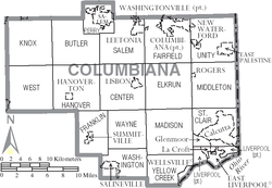
Geography
According to the U.S. Census BureauUnited States Census Bureau
The United States Census Bureau is the government agency that is responsible for the United States Census. It also gathers other national demographic and economic data...
, the county has a total area of 535 square miles (1,385.6 km²).532 square miles (1,377.9 km²) is land and 3 square miles (7.8 km²) (0.51%) is water.
Adjacent counties
- Mahoning County (north)
- Lawrence County, PennsylvaniaLawrence County, PennsylvaniaLawrence County is a county located in the U.S. state of Pennsylvania. In 2010, its population was 91,108. The county was added to the Pittsburgh Metropolitan Statistical Area in 2003. The county seat is New Castle....
(northeast) - Beaver County, PennsylvaniaBeaver County, Pennsylvania-Demographics:As of the census of 2000, there were 181,412 people, 72,576 households, and 50,512 families residing in the county. The population density was 418 people per square mile . There were 77,765 housing units at an average density of 179 per square mile...
(east) - Hancock County, West VirginiaHancock County, West VirginiaAs of the census of 2000, there were 32,667 people, 13,678 households, and 9,506 families residing in the county. The population density was 394 people per square mile . There were 14,728 housing units at an average density of 178 per square mile...
(southeast) - Jefferson CountyJefferson County, OhioJefferson County is a county located in the state of Ohio. As of 2010, the population was 69,709. Its county seat is Steubenville and is named for Thomas Jefferson, who was at the time Vice President....
(south) - Carroll CountyCarroll County, OhioCarroll County is a county located in the state of Ohio. As of 2010, the population was 28,836, no change from 2000. Its county seat is Carrollton. It is named for Charles Carroll of Carrollton, the last surviving signer of the Declaration of Independence....
(southwest) - Stark CountyStark County, OhioStark County is a county located in the U.S. state of Ohio. As of the 2010 census, the population was 375,586. It is included in the Canton-Massillon, Ohio Metropolitan Statistical Area....
(west)
Demographics
As of the censusCensus
A census is the procedure of systematically acquiring and recording information about the members of a given population. It is a regularly occurring and official count of a particular population. The term is used mostly in connection with national population and housing censuses; other common...
of 2000, there were 112,075 people, 42,973 households, and 30,682 families residing in the county. The population density
Population density
Population density is a measurement of population per unit area or unit volume. It is frequently applied to living organisms, and particularly to humans...
was 210 people per square mile (81/km²). There were 46,083 housing units at an average density of 86 per square mile (33/km²). The racial makeup of the county was 96.43% White
Race (United States Census)
Race and ethnicity in the United States Census, as defined by the Federal Office of Management and Budget and the United States Census Bureau, are self-identification data items in which residents choose the race or races with which they most closely identify, and indicate whether or not they are...
, 2.20% Black
Race (United States Census)
Race and ethnicity in the United States Census, as defined by the Federal Office of Management and Budget and the United States Census Bureau, are self-identification data items in which residents choose the race or races with which they most closely identify, and indicate whether or not they are...
or African American
Race (United States Census)
Race and ethnicity in the United States Census, as defined by the Federal Office of Management and Budget and the United States Census Bureau, are self-identification data items in which residents choose the race or races with which they most closely identify, and indicate whether or not they are...
, 0.18% Native American
Race (United States Census)
Race and ethnicity in the United States Census, as defined by the Federal Office of Management and Budget and the United States Census Bureau, are self-identification data items in which residents choose the race or races with which they most closely identify, and indicate whether or not they are...
, 0.23% Asian
Race (United States Census)
Race and ethnicity in the United States Census, as defined by the Federal Office of Management and Budget and the United States Census Bureau, are self-identification data items in which residents choose the race or races with which they most closely identify, and indicate whether or not they are...
, 0.02% Pacific Islander
Race (United States Census)
Race and ethnicity in the United States Census, as defined by the Federal Office of Management and Budget and the United States Census Bureau, are self-identification data items in which residents choose the race or races with which they most closely identify, and indicate whether or not they are...
, 0.15% from other races
Race (United States Census)
Race and ethnicity in the United States Census, as defined by the Federal Office of Management and Budget and the United States Census Bureau, are self-identification data items in which residents choose the race or races with which they most closely identify, and indicate whether or not they are...
, and 0.79% from two or more races. 1.17% of the population were Hispanic
Race (United States Census)
Race and ethnicity in the United States Census, as defined by the Federal Office of Management and Budget and the United States Census Bureau, are self-identification data items in which residents choose the race or races with which they most closely identify, and indicate whether or not they are...
or Latino
Race (United States Census)
Race and ethnicity in the United States Census, as defined by the Federal Office of Management and Budget and the United States Census Bureau, are self-identification data items in which residents choose the race or races with which they most closely identify, and indicate whether or not they are...
of any race. 24.0% were of German
Germans
The Germans are a Germanic ethnic group native to Central Europe. The English term Germans has referred to the German-speaking population of the Holy Roman Empire since the Late Middle Ages....
, 12.9% English
English people
The English are a nation and ethnic group native to England, who speak English. The English identity is of early mediaeval origin, when they were known in Old English as the Anglecynn. England is now a country of the United Kingdom, and the majority of English people in England are British Citizens...
, 12.8% American
United States
The United States of America is a federal constitutional republic comprising fifty states and a federal district...
, 12.3% Irish
Irish people
The Irish people are an ethnic group who originate in Ireland, an island in northwestern Europe. Ireland has been populated for around 9,000 years , with the Irish people's earliest ancestors recorded having legends of being descended from groups such as the Nemedians, Fomorians, Fir Bolg, Tuatha...
and 9.3% Italian ancestry according to Census 2000.
There were 42,973 households out of which 31.70% had children under the age of 18 living with them, 57.10% were married couples
Marriage
Marriage is a social union or legal contract between people that creates kinship. It is an institution in which interpersonal relationships, usually intimate and sexual, are acknowledged in a variety of ways, depending on the culture or subculture in which it is found...
living together, 10.30% had a female householder with no husband present, and 28.60% were non-families. 24.80% of all households were made up of individuals and 11.90% had someone living alone who was 65 years of age or older. The average household size was 2.52 and the average family size was 3.00.
In the county the population was spread out with 24.30% under the age of 18, 7.80% from 18 to 24, 28.60% from 25 to 44, 24.20% from 45 to 64, and 15.00% who were 65 years of age or older. The median age was 38 years. For every 100 females there were 98.80 males. For every 100 females age 18 and over, there were 96.60 males.
The median income for a household in the county was $34,226, and the median income for a family was $40,486. Males had a median income of $32,134 versus $20,331 for females. The per capita income
Per capita income
Per capita income or income per person is a measure of mean income within an economic aggregate, such as a country or city. It is calculated by taking a measure of all sources of income in the aggregate and dividing it by the total population...
for the county was $16,655. About 9.00% of families and 11.50% of the population were below the poverty line, including 16.20% of those under age 18 and 8.40% of those age 65 or over.
Census Statistical Areas
Columbiana County is the sole county in the East Liverpool-Salem, OH μSA (Micropolitan Statistical Area) and one of four counties in the Youngstown-Warren-East Liverpool, OH-PA CSA (Combined Statistical AreaCombined Statistical Area
The United States Office of Management and Budget defines micropolitan and metropolitan statistical areas. Metropolitan and micropolitan statistical areas consist of one or more counties...
) as defined by United States Census Bureau
United States Census Bureau
The United States Census Bureau is the government agency that is responsible for the United States Census. It also gathers other national demographic and economic data...
. Census Bureau Statistical areas indicate an area with noteworthy economic or employment interactions.
Government
Communities
Cities
|
East Palestine, Ohio East Palestine is a city in Unity Township, Columbiana County, Ohio, United States, near the border with Pennsylvania. The population was 4,917 at the 2000 census.... Salem, Ohio Salem is a city in northern Columbiana County and extreme southern Mahoning County, Ohio, United States. At the 2000 census, the city's population was 12,197.... |
Villages
|
New Waterford, Ohio New Waterford is a village in Columbiana County, Ohio, United States. The population was 1,391 at the 2000 census.-Geography:New Waterford is located at .... Rogers, Ohio Rogers is a village in Columbiana County, Ohio, United States. The population was 266 at the 2000 census.-Geography:Rogers is located at .... Salineville, Ohio Salineville is a village in southwestern Columbiana County, Ohio, United States. The population was 1,397 at the 2000 census.The Civil War Battle of Salineville, which ended Morgan's Raid and resulted in the capture of Confederate General John Hunt Morgan, took place near Salineville on July 26,... |
Summitville, Ohio Summitville is a village in Columbiana County, Ohio, United States. The population was 108 at the 2000 census.-Geography:Summitville is located at .... Washingtonville, Ohio Washingtonville is a village in Columbiana and Mahoning counties in the U.S. state of Ohio. The population was 789 at the 2000 census. Washingtonville is split between the East Liverpool–Salem Micropolitan Statistical Area and the Youngstown–Warren–Boardman, OH-PA Metropolitan... Wellsville, Ohio Wellsville is a village in Columbiana County, Ohio, United States, along the Ohio River. The population was 4,133 at the 2000 census.-History:... |
Townships
|
Knox Township, Columbiana County, Ohio Knox Township is one of the eighteen townships of Columbiana County, Ohio, United States. The 2000 census found 4,828 people in the township.-Geography:Located in the northwestern corner of the county, it borders the following townships and city:... Liverpool Township, Columbiana County, Ohio Liverpool Township is one of the eighteen townships of Columbiana County, Ohio, United States. The 2000 census found 4,374 people in the township.-Geography:... Madison Township, Columbiana County, Ohio Madison Township is one of the eighteen townships of Columbiana County, Ohio, United States. The 2000 census found 3,406 people in the township.-Geography:Located in the southeastern part of the county, it borders the following townships:... Middleton Township, Columbiana County, Ohio Middleton Township is one of the eighteen townships of Columbiana County, Ohio, United States. The 2000 census found 3,741 people in the township, 3,475 of whom lived in the unincorporated portions of the township.-Geography:... Perry Township, Columbiana County, Ohio Perry Township is one of the eighteen townships of Columbiana County, Ohio, United States. The 2000 census found 17,049 people in the township, 4,852 of whom lived in the unincorporated portions of the township.-Geography:... Salem Township, Columbiana County, Ohio Salem Township is one of the eighteen townships of Columbiana County, Ohio, United States. The 2000 census found 5,703 people in the township, 3,338 of whom lived in the unincorporated portions of the township.-Geography:... |
St. Clair Township, Columbiana County, Ohio St. Clair Township is one of the eighteen townships of Columbiana County, Ohio, United States. The 2000 census found 7,961 people in the township.-Geography:Located in the southeastern part of the county, it borders the following townships and borough:... Unity Township, Columbiana County, Ohio Unity Township is one of the eighteen townships of Columbiana County, Ohio, United States. The 2000 census found 10,294 people in the township, 3,969 of whom lived in the unincorporated portions of the township.-Geography:... Washington Township, Columbiana County, Ohio Washington Township is one of the eighteen townships of Columbiana County, Ohio, United States. The 2000 census found 2,380 people in the township, 983 of whom lived in the unincorporated portions of the township.-Geography:... Wayne Township, Columbiana County, Ohio Wayne Township is one of the eighteen townships of Columbiana County, Ohio, United States. The 2000 census found 785 people in the township.-Geography:Located in the southern part of the county, it borders the following townships:*Center Township - north... West Township, Columbiana County, Ohio West Township is one of the eighteen townships of Columbiana County, Ohio, United States. The 2000 census found 3,351 people in the township, 3,346 of whom lived in the unincorporated portions of the township.-Geography:... Yellow Creek Township, Columbiana County, Ohio Yellow Creek Township is one of the eighteen townships of Columbiana County, Ohio, United States. The 2000 census found 2,185 people in the township.-Geography:... |
Census-designated places
- CalcuttaCalcutta, OhioCalcutta is a census-designated place in Columbiana County, Ohio, United States. The population was 3,491 at the 2000 census. Much of Calcutta is located on Ohio State Route 170.-Geography:Calcutta is located at ....
- GlenmoorGlenmoor, OhioGlenmoor is a census-designated place in Columbiana County, Ohio, United States. The population was 2,192 at the 2000 census.-Geography:Glenmoor is located at ....
- La CroftLa Croft, OhioLa Croft is a census-designated place in Columbiana County, Ohio, United States. The population was 1,307 at the 2000 census.-Geography:La Croft is located at ....
Other communities
|
Fredericktown, Columbiana County, Ohio Fredericktown is a historic unincorporated community at the confluence of the north and middle forks of Little Beaver Creek in northeastern St. Clair Township, Columbiana County, Ohio, United States. It lies about six miles north of nearby East Liverpool and about 50 miles west of Pittsburgh,... Homeworth, Ohio Homeworth is a census-designated place in Knox Township, Columbiana County, Ohio, United States.Located in southwestern Knox Township, aside from homes, the area around Homeworth has farms, hills, fields, and cows.... Kensington, Ohio Kensington is an unincorporated community in southwestern Hanover Township, Columbiana County, Ohio, United States. Although it is unincorporated, it has a post office, with the ZIP code of 44427. It lies along U.S. Route 30 at its intersection with State Routes 9 and 644.-References:... Negley, Ohio Negley is a census-designated place in northeastern Middleton Township, Columbiana County, Ohio, United States. Although it is unincorporated, it has a post office, with the ZIP code of 44441. It lies along State Route 154.... |
North Georgetown, Ohio North Georgetown is an unincorporated community in western Knox Township, Columbiana County, Ohio, United States. Although it is unincorporated, it has a post office, with the ZIP code of 44665... West Point, Ohio West Point is an unincorporated community in northern Madison Township, Columbiana County, Ohio, United States. Although it is unincorporated, it has a post office, with the ZIP code of 44492. It lies along U.S... Winona, Ohio Winona is an unincorporated community in southeastern Butler Township, Columbiana County, Ohio, United States. Although it is unincorporated, it has a post office, with the ZIP code of 44493.-References:... |