
.gif)
Interstate 670 (Ohio)
Encyclopedia
U.S. state
A U.S. state is any one of the 50 federated states of the United States of America that share sovereignty with the federal government. Because of this shared sovereignty, an American is a citizen both of the federal entity and of his or her state of domicile. Four states use the official title of...
of Ohio
Ohio
Ohio is a Midwestern state in the United States. The 34th largest state by area in the U.S.,it is the 7th‑most populous with over 11.5 million residents, containing several major American cities and seven metropolitan areas with populations of 500,000 or more.The state's capital is Columbus...
that passes through downtown Columbus, connecting I-70
Interstate 70 in Ohio
In the U.S. state of Ohio, Interstate 70 provides access between Indiana and West Virginia.-Route description:Along its path through Ohio, Interstate 70 passes through the following counties: Preble, Montgomery, Clark, Madison, Franklin, Fairfield, Licking, Muskingum, Guernsey and Belmont County...
west of downtown with I-270
Interstate 270 (Ohio)
Interstate 270 is the beltway loop freeway in the Columbus metropolitan area, commonly known locally as "The Outerbelt," or the "Jack Nicklaus Freeway." The "western" terminus of I-270, at least in terms of the zero-milepost, is at the junction with I-71 east of Grove City, Ohio...
and US 62 near the eastern suburb of Gahanna. I-670 provides access to Port Columbus International Airport
Port Columbus International Airport
Port Columbus International Airport , commonly shortened to Port Columbus, is a Class C international airport located east of downtown Columbus, Ohio, USA. It is managed by the Columbus Regional Airport Authority, which also oversees operations at Rickenbacker International Airport and Bolton Field...
, and intersects SR 315 and I-71 downtown. The section between SR 315 and I-71 is commonly referred to by locals as the "North Innerbelt", with the rest of the innerbelt consisting of SR 315 (west), I-70 (south), and I-71 (east and south).
History
In the late 1970s, the Ohio Department of TransportationOhio Department of Transportation
The Ohio Department of Transportation is the organization of state government responsible for developing and maintaining all state and federal roadways in the state of Ohio with exception of the Ohio Turnpike. In addition to highways, the department also helps develop public transportation and...
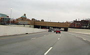
was unable to complete the Spring-Sandusky interchange, linking both sections of the highway, due to budget shortfalls and environmental regulations, leaving I-670 the only uncompleted Interstate in Ohio. Two decades passed before work began on the last remaining section, bridging the gap between the two completed sections. Work on this section also included the High Street cap, a cut-and-cover bridge over the highway featuring shops and restaurants. I-670 was finally completed in 2003.
Route description
West of I-71, I-670 passes around both sides of Fort HayesFort Hayes
Fort Hayes, a military post in Columbus, Ohio, United States, was created by an act of the United States Congress in 1877. As of 2007, the property is primarily used for the Columbus School District's Fort Hayes Metropolitan Education Center and bus depot. Currently, the 391st Military Police...
with two two-way roadways. The south roadway carries the eastbound main lanes and the westbound entrance ramps from I-71 north and SR 3 (Cleveland Avenue), while the north roadway carries the westbound main lanes and the eastbound entrance from US 23 north (4th Street) and High Street.
Exit list
The entire route is in Franklin CountyFranklin County, Ohio
Franklin County is a county located in the state of Ohio, United States. In 2010 the population was 1,163,414, making it the second largest county in Ohio and the 34th largest county in population in the United States. Franklin County is also the largest in the eight-county Columbus, Ohio...
.
| Location | Mile | # Exit number An exit number is a number assigned to a road junction, usually an exit from a freeway. It is usually marked on the same sign as the destinations of the exit, as well as a sign in the gore.... |
Destinations | Notes |
|---|---|---|---|---|
| Columbus Columbus, Ohio Columbus is the capital of and the largest city in the U.S. state of Ohio. The broader metropolitan area encompasses several counties and is the third largest in Ohio behind those of Cleveland and Cincinnati. Columbus is the third largest city in the American Midwest, and the fifteenth largest city... |
0.00 | , Indianapolis Indianapolis, Indiana Indianapolis is the capital of the U.S. state of Indiana, and the county seat of Marion County, Indiana. As of the 2010 United States Census, the city's population is 839,489. It is by far Indiana's largest city and, as of the 2010 U.S... |
Westbound exit and eastbound entrance. No guide signage exists to inform WB traffic what freeway they are on for several miles beyond the end of I-670. | |
| 0.46 | 1A | Westbound exit and eastbound entrance | ||
| 0.95 | 1B | Grandview Avenue | Signed as exit 1 eastbound | |
| 2.24 | 2A | Eastbound exit and westbound entrance; connection to 315 ramps via traffic signals and (for NB-WB traffic) a short stretch of 33 | ||
| 2.42 | 2A | Westbound exit and eastbound entrance | ||
| 2.43 | 2B | |||
| 3.14 | 3 | Goodale Street, Neil Avenue | ||
| 3.52- 3.95 |
4 | Signed as exits 4A (south) and 4B (north) eastbound and 4A (north) and 4B (south) westbound | ||
| 4.33 | 4C | Westbound exit is part of exit 5 | ||
| 4.58- 4.76 |
5 | Exit to downtown (via Lester Dr / Spring St) accessed from westbound only. | ||
| 6.44 | 6 | Leonard Avenue | ||
| 7.56 | 7 | West end of US 62 overlap | ||
| 8.50- 9.06 |
9 | Johnstown Road, Cassady Avenue, Stelzer Road - Port Columbus International Airport Port Columbus International Airport Port Columbus International Airport , commonly shortened to Port Columbus, is a Class C international airport located east of downtown Columbus, Ohio, USA. It is managed by the Columbus Regional Airport Authority, which also oversees operations at Rickenbacker International Airport and Bolton Field... |
||
| 10.43 | , Wheeling Wheeling, West Virginia Wheeling is a city in Ohio and Marshall counties in the U.S. state of West Virginia; it is the county seat of Ohio County. Wheeling is the principal city of the Wheeling Metropolitan Statistical Area... |
|||
| 10.43 | Continuation beyond I-270 |