

Jefferson County, Ohio
Encyclopedia
Jefferson County is a county located in the state
of Ohio
. As of 2010, the population was 69,709. http://quickfacts.census.gov/qfd/states/39/39081.html Its county seat
is Steubenville
and is named for Thomas Jefferson
, who was at the time Vice President.
Jefferson County is part of the Weirton-Steubenville, WV-OH Metropolitan Statistical Area
.
In 1786, the United States built Fort Steuben to protect the government surveyors mapping the land west of the Ohio River. When the surveyors completed their task a few years later, the fort was abandoned. In the meantime, settlers had built homes around the fort; they named their settlement La Belle. When the County was created in 1797, La Belle was selected as the County seat. The town was subsequently renamed Steubenville, in honor of the abandoned fort.
During the first half of the nineteenth century, Jefferson County attracted a number of pioneers who were looking for a better life in the newly developing lands west of the Ohio River. Included in those brave souls were a large number of American Revolution war veterans, as well as several groups of Quakers. For example, the villages of Mt. Pleasant and Smithfield were founded by Quakers, which became early centers for abolitionist activity.
During the first half of the nineteenth century, Steubenville was primarily a port town, and the rest of the county was small villages and farms. However, in 1856, Frazier, Kilgore and Company erected a rolling mill (the forerunner of steel mills) and the Steubenville Coal and Mining Company sank a coal shaft, resulting in Jefferson County becoming one of the leading centers of the new Industrial Revolution.
Jefferson County is a virtual treasure trove for history and genealogy researchers. It has over seventy pioneer cemeteries, the oldest Quaker meeting house west of the Ohio River, well preserved sites on the Underground Railroad, and the old Fort Steuben has been completely rebuilt as a public historic site and museum. Several of the towns and villages have formed historical societies, dedicated to preserving local history.
Click here to visit the Jefferson County Chapter of the Ohio Genealogical Society's Website
, the county has a total area of 411 square miles (1,064.5 km²).410 square miles (1,061.9 km²) is land and 1 square miles (2.6 km²) (0.31%) is water.
of 2000, there were 73,894 people, 30,417 households, and 20,592 families residing in the county. The population density
was 180 people per square mile (70/km²). There were 33,291 housing units at an average density of 81 per square mile (31/km²). The racial makeup of the county was 92.49% White
, 5.68% Black
or African American
, 0.20% Native American
, 0.33% Asian
, 0.02% Pacific Islander
, 0.25% from other races
, and 1.03% from two or more races. 0.62% of the population were Hispanic
or Latino
of any race. 96.5% spoke English
, 1.1% Spanish
and 1.0% Italian
as their first language.
There were 30,417 households out of which 26.70% had children under the age of 18 living with them, 52.30% were married couples
living together, 11.60% had a female householder with no husband present, and 32.30% were non-families. 28.50% of all households were made up of individuals and 14.40% had someone living alone who was 65 years of age or older. The average household size was 2.36 and the average family size was 2.88.
In the county, the population was spread out with 21.40% under the age of 18, 8.50% from 18 to 24, 25.60% from 25 to 44, 25.90% from 45 to 64, and 18.60% who were 65 years of age or older. The median age was 42 years. For every 100 females there were 91.20 males. For every 100 females age 18 and over, there were 87.50 males.
The median income for a household in the county was $30,853, and the median income for a family was $38,807. Males had a median income of $35,785 versus $20,375 for females. The per capita income
for the county was $16,476. About 11.40% of families and 15.10% of the population were below the poverty line, including 22.30% of those under age 18 and 8.90% of those age 65 or over.
Prosecutor: Thomas Straus
Sheriff: Fred Abdalla
Auditor: Patrick J. Marshall
Treasurer: Raymond M. Agresta
Engineer: James Branagan
Judges of the Court of Common Pleas
: Hon. Joseph J. Bruzzese Jr, Hon. David E. Henderson
Probate Court: Hon. Samuel W. Kerr
Clerk of Courts: John A. Corrigan
Health Commissioner: Frank J. Petrola, M.D.
Director, Board of Elections: Diane M. Gribble
Director, Job and Family Services: Nicholas Balakos
Director, Progress Alliance: Ed Looman
U.S. state
A U.S. state is any one of the 50 federated states of the United States of America that share sovereignty with the federal government. Because of this shared sovereignty, an American is a citizen both of the federal entity and of his or her state of domicile. Four states use the official title of...
of Ohio
Ohio
Ohio is a Midwestern state in the United States. The 34th largest state by area in the U.S.,it is the 7th‑most populous with over 11.5 million residents, containing several major American cities and seven metropolitan areas with populations of 500,000 or more.The state's capital is Columbus...
. As of 2010, the population was 69,709. http://quickfacts.census.gov/qfd/states/39/39081.html Its county seat
County seat
A county seat is an administrative center, or seat of government, for a county or civil parish. The term is primarily used in the United States....
is Steubenville
Steubenville, Ohio
Steubenville is a city located along the Ohio River in Jefferson County, Ohio on the Ohio-West Virginia border in the United States. It is the political county seat of Jefferson County. It is also a principal city of the Weirton–Steubenville, WV-OH Metropolitan Statistical Area...
and is named for Thomas Jefferson
Thomas Jefferson
Thomas Jefferson was the principal author of the United States Declaration of Independence and the Statute of Virginia for Religious Freedom , the third President of the United States and founder of the University of Virginia...
, who was at the time Vice President.
Jefferson County is part of the Weirton-Steubenville, WV-OH Metropolitan Statistical Area
Weirton-Steubenville metropolitan area
The Weirton-Steubenville Metropolitan Statistical Area, as defined by the United States Census Bureau, is an area consisting of two counties in the Northern Panhandle of West Virginia and one in Ohio, anchored by the cities of Weirton, West Virginia, and Steubenville, Ohio...
.
History
Jefferson County was named for Thomas Jefferson, author of the Declaration of Independence, Secretary of State, and Vice President of the United States at the time of the County’s creation. It was organized on July 29, 1797 by proclamation of Governor Arthur St. Clair, six years before Ohio was granted statehood.In 1786, the United States built Fort Steuben to protect the government surveyors mapping the land west of the Ohio River. When the surveyors completed their task a few years later, the fort was abandoned. In the meantime, settlers had built homes around the fort; they named their settlement La Belle. When the County was created in 1797, La Belle was selected as the County seat. The town was subsequently renamed Steubenville, in honor of the abandoned fort.
During the first half of the nineteenth century, Jefferson County attracted a number of pioneers who were looking for a better life in the newly developing lands west of the Ohio River. Included in those brave souls were a large number of American Revolution war veterans, as well as several groups of Quakers. For example, the villages of Mt. Pleasant and Smithfield were founded by Quakers, which became early centers for abolitionist activity.
During the first half of the nineteenth century, Steubenville was primarily a port town, and the rest of the county was small villages and farms. However, in 1856, Frazier, Kilgore and Company erected a rolling mill (the forerunner of steel mills) and the Steubenville Coal and Mining Company sank a coal shaft, resulting in Jefferson County becoming one of the leading centers of the new Industrial Revolution.
Jefferson County is a virtual treasure trove for history and genealogy researchers. It has over seventy pioneer cemeteries, the oldest Quaker meeting house west of the Ohio River, well preserved sites on the Underground Railroad, and the old Fort Steuben has been completely rebuilt as a public historic site and museum. Several of the towns and villages have formed historical societies, dedicated to preserving local history.
Click here to visit the Jefferson County Chapter of the Ohio Genealogical Society's Website
Geography
According to the U.S. Census BureauUnited States Census Bureau
The United States Census Bureau is the government agency that is responsible for the United States Census. It also gathers other national demographic and economic data...
, the county has a total area of 411 square miles (1,064.5 km²).410 square miles (1,061.9 km²) is land and 1 square miles (2.6 km²) (0.31%) is water.
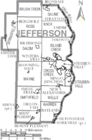
Adjacent counties
- Columbiana CountyColumbiana County, OhioColumbiana County is a county located in the U.S. state of Ohio. As of 2010, the population was 107,841. It is named for Christopher Columbus and the county seat is Lisbon....
(north) - Hancock County, West VirginiaHancock County, West VirginiaAs of the census of 2000, there were 32,667 people, 13,678 households, and 9,506 families residing in the county. The population density was 394 people per square mile . There were 14,728 housing units at an average density of 178 per square mile...
(northeast) - Brooke County, West VirginiaBrooke County, West VirginiaAs of the census of 2000, there were 25,447 people, 10,396 households, and 7,152 families residing in the county. The population density was 286 people per square mile . There were 11,150 housing units at an average density of 126 per square mile...
(east) - Ohio County, West VirginiaOhio County, West VirginiaAs of the census of 2000, there were 47,427 people, 19,733 households, and 12,155 families residing in the county. The population density was 447 people per square mile . There were 22,166 housing units at an average density of 209 per square mile...
(southeast) - Belmont CountyBelmont County, OhioBelmont County is a county located in the U.S. state of Ohio. It is part of the Wheeling, West Virginia Metropolitan Statistical Area. As of 2010, the population was 70,400. Its county seat is St. Clairsville...
(south) - Harrison County (southwest)
- Carroll CountyCarroll County, OhioCarroll County is a county located in the state of Ohio. As of 2010, the population was 28,836, no change from 2000. Its county seat is Carrollton. It is named for Charles Carroll of Carrollton, the last surviving signer of the Declaration of Independence....
(northwest)
Demographics
As of the censusCensus
A census is the procedure of systematically acquiring and recording information about the members of a given population. It is a regularly occurring and official count of a particular population. The term is used mostly in connection with national population and housing censuses; other common...
of 2000, there were 73,894 people, 30,417 households, and 20,592 families residing in the county. The population density
Population density
Population density is a measurement of population per unit area or unit volume. It is frequently applied to living organisms, and particularly to humans...
was 180 people per square mile (70/km²). There were 33,291 housing units at an average density of 81 per square mile (31/km²). The racial makeup of the county was 92.49% White
Race (United States Census)
Race and ethnicity in the United States Census, as defined by the Federal Office of Management and Budget and the United States Census Bureau, are self-identification data items in which residents choose the race or races with which they most closely identify, and indicate whether or not they are...
, 5.68% Black
Race (United States Census)
Race and ethnicity in the United States Census, as defined by the Federal Office of Management and Budget and the United States Census Bureau, are self-identification data items in which residents choose the race or races with which they most closely identify, and indicate whether or not they are...
or African American
Race (United States Census)
Race and ethnicity in the United States Census, as defined by the Federal Office of Management and Budget and the United States Census Bureau, are self-identification data items in which residents choose the race or races with which they most closely identify, and indicate whether or not they are...
, 0.20% Native American
Race (United States Census)
Race and ethnicity in the United States Census, as defined by the Federal Office of Management and Budget and the United States Census Bureau, are self-identification data items in which residents choose the race or races with which they most closely identify, and indicate whether or not they are...
, 0.33% Asian
Race (United States Census)
Race and ethnicity in the United States Census, as defined by the Federal Office of Management and Budget and the United States Census Bureau, are self-identification data items in which residents choose the race or races with which they most closely identify, and indicate whether or not they are...
, 0.02% Pacific Islander
Race (United States Census)
Race and ethnicity in the United States Census, as defined by the Federal Office of Management and Budget and the United States Census Bureau, are self-identification data items in which residents choose the race or races with which they most closely identify, and indicate whether or not they are...
, 0.25% from other races
Race (United States Census)
Race and ethnicity in the United States Census, as defined by the Federal Office of Management and Budget and the United States Census Bureau, are self-identification data items in which residents choose the race or races with which they most closely identify, and indicate whether or not they are...
, and 1.03% from two or more races. 0.62% of the population were Hispanic
Race (United States Census)
Race and ethnicity in the United States Census, as defined by the Federal Office of Management and Budget and the United States Census Bureau, are self-identification data items in which residents choose the race or races with which they most closely identify, and indicate whether or not they are...
or Latino
Race (United States Census)
Race and ethnicity in the United States Census, as defined by the Federal Office of Management and Budget and the United States Census Bureau, are self-identification data items in which residents choose the race or races with which they most closely identify, and indicate whether or not they are...
of any race. 96.5% spoke English
English language
English is a West Germanic language that arose in the Anglo-Saxon kingdoms of England and spread into what was to become south-east Scotland under the influence of the Anglian medieval kingdom of Northumbria...
, 1.1% Spanish
Spanish language
Spanish , also known as Castilian , is a Romance language in the Ibero-Romance group that evolved from several languages and dialects in central-northern Iberia around the 9th century and gradually spread with the expansion of the Kingdom of Castile into central and southern Iberia during the...
and 1.0% Italian
Italian language
Italian is a Romance language spoken mainly in Europe: Italy, Switzerland, San Marino, Vatican City, by minorities in Malta, Monaco, Croatia, Slovenia, France, Libya, Eritrea, and Somalia, and by immigrant communities in the Americas and Australia...
as their first language.
There were 30,417 households out of which 26.70% had children under the age of 18 living with them, 52.30% were married couples
Marriage
Marriage is a social union or legal contract between people that creates kinship. It is an institution in which interpersonal relationships, usually intimate and sexual, are acknowledged in a variety of ways, depending on the culture or subculture in which it is found...
living together, 11.60% had a female householder with no husband present, and 32.30% were non-families. 28.50% of all households were made up of individuals and 14.40% had someone living alone who was 65 years of age or older. The average household size was 2.36 and the average family size was 2.88.
In the county, the population was spread out with 21.40% under the age of 18, 8.50% from 18 to 24, 25.60% from 25 to 44, 25.90% from 45 to 64, and 18.60% who were 65 years of age or older. The median age was 42 years. For every 100 females there were 91.20 males. For every 100 females age 18 and over, there were 87.50 males.
The median income for a household in the county was $30,853, and the median income for a family was $38,807. Males had a median income of $35,785 versus $20,375 for females. The per capita income
Per capita income
Per capita income or income per person is a measure of mean income within an economic aggregate, such as a country or city. It is calculated by taking a measure of all sources of income in the aggregate and dividing it by the total population...
for the county was $16,476. About 11.40% of families and 15.10% of the population were below the poverty line, including 22.30% of those under age 18 and 8.90% of those age 65 or over.
Government
Commissioners: Thomas Graham, Ph.D, Dave Maple, and Adam ScurtiProsecutor: Thomas Straus
Sheriff: Fred Abdalla
Auditor: Patrick J. Marshall
Treasurer: Raymond M. Agresta
Engineer: James Branagan
Judges of the Court of Common Pleas
Ohio Courts of Common Pleas
The Ohio Courts of Common Pleas are the trial courts of the state court system of Ohio.The courts of common pleas are the trial courts of general jurisdiction in the state. They are the only trial courts created by the Ohio Constitution . The duties of the courts are outlined in Article IV, Section...
: Hon. Joseph J. Bruzzese Jr, Hon. David E. Henderson
Probate Court: Hon. Samuel W. Kerr
Clerk of Courts: John A. Corrigan
Health Commissioner: Frank J. Petrola, M.D.
Director, Board of Elections: Diane M. Gribble
Director, Job and Family Services: Nicholas Balakos
Director, Progress Alliance: Ed Looman
Communities
Villages
|
Empire, Ohio Empire is a village in Jefferson County, Ohio, United States, along the Ohio River. The population was 300 at the 2000 census. It is part of the Weirton–Steubenville, WV-OH Metropolitan Statistical Area.-Geography:... Irondale, Ohio Irondale is a village in Jefferson County, Ohio, United States. The population was 418 at the 2000 census. It is part of the Weirton–Steubenville, WV-OH Metropolitan Statistical Area.-Geography:Irondale is located at .... Mingo Junction, Ohio Mingo Junction is a village in Jefferson County, Ohio, United States, along the Ohio River. The population was 3,631 at the 2000 census. In 1900, its only manufacturing plant was a steel mill owned by Carnegie Steel Company... Mount Pleasant, Ohio Mount Pleasant is a village in Jefferson County, Ohio, in the United States. As of the 2000 census, the village population was 535. It is part of the Weirton–Steubenville, WV-OH Metropolitan Statistical Area.-History:... |
New Alexandria, Ohio New Alexandria is a village in Jefferson County, Ohio, United States. The population was 222 at the 2000 census. It is part of the Weirton–Steubenville, WV-OH Metropolitan Statistical Area.... Rayland, Ohio Rayland is a village in Jefferson County, Ohio, United States, along the Ohio River. The population was 434 at the 2000 census. It is part of the Weirton–Steubenville, WV-OH Metropolitan Statistical Area.-Geography:... Richmond, Ohio Richmond is a village in Jefferson County, Ohio, United States. The population was 471 at the 2000 census. It is part of the Weirton–Steubenville, WV-OH Metropolitan Statistical Area.... Smithfield, Ohio Smithfield is a village in Jefferson County, Ohio, United States. The population was 867 at the 2000 census. It is part of the Weirton–Steubenville, WV-OH Metropolitan Statistical Area.... |
Stratton, Ohio Stratton is a village in Jefferson County, Ohio, United States, along the Ohio River. The population was 277 at the 2000 census. It is part of the Weirton–Steubenville, WV-OH Metropolitan Statistical Area. A major local employer is the W. H... Tiltonsville, Ohio Tiltonsville is a village in Jefferson County, Ohio, United States, along the Ohio River. The population was 1,329 at the 2000 census. It is part of the Weirton–Steubenville, WV-OH Metropolitan Statistical Area... Wintersville, Ohio Wintersville is a village in Jefferson County, Ohio, United States. As of the 2000 census, the village had a population of 4,067. It is part of the Weirton–Steubenville, WV-OH Metropolitan Statistical Area.... Yorkville, Ohio Yorkville is a village in Belmont and Jefferson counties in the U.S. state of Ohio. The population was 1,230 at the 2000 census.Yorkville lies within two Metropolitan Statistical Areas – the Belmont County portion is part of the Wheeling metropolitan area, while the Jefferson County portion... |
Townships
|
Mount Pleasant Township, Jefferson County, Ohio Mount Pleasant Township is one of the fourteen townships of Jefferson County, Ohio, United States. The 2000 census found 2,588 people in the township, 1,503 of whom lived in the unincorporated portions of the township.-Geography:... Ross Township, Jefferson County, Ohio Ross Township is one of the fourteen townships of Jefferson County, Ohio, United States. The 2000 census found 655 people in the township.-Geography:Located in the northwestern part of the county, it borders the following townships:... Salem Township, Jefferson County, Ohio Salem Township is one of the fourteen townships of Jefferson County, Ohio, United States. The 2000 census found 3,162 people in the township, 2,691 of whom lived in the unincorporated portions of the township.-Geography:... Saline Township, Jefferson County, Ohio Saline Township is one of the fourteen townships of Jefferson County, Ohio, United States. The 2000 census found 1,454 people in the township, 1,011 of whom lived in the unincorporated portions of the township.-Geography:... |
Smithfield Township, Jefferson County, Ohio Smithfield Township is one of the fourteen townships of Jefferson County, Ohio, United States. The 2000 census found 3,578 people in the township, 1,804 of whom lived in the unincorporated portions of the township.-Geography:... Springfield Township, Jefferson County, Ohio Springfield Township is one of the fourteen townships of Jefferson County, Ohio, United States. The 2000 census found 2,568 people in the township, 1,231 of whom lived in the unincorporated portions of the township.-Geography:... Steubenville Township, Jefferson County, Ohio Steubenville Township is one of the fourteen townships of Jefferson County, Ohio, United States. The 2000 census found 4,695 people in the township, 1,064 of whom lived in the unincorporated portions of the township.-Geography:... |
Warren Township, Jefferson County, Ohio Warren Township is one of the fourteen townships of Jefferson County, Ohio, United States. The 2000 census found 4,499 people in the township, 2,044 of whom lived in the unincorporated portions of the township.-Geography:... Wayne Township, Jefferson County, Ohio Wayne Township is one of the fourteen townships of Jefferson County, Ohio, United States. The 2000 census found 2,233 people in the township, 2,012 of whom lived in the unincorporated portions of the township.-Geography:... Wells Township, Jefferson County, Ohio Wells Township is one of the fourteen townships of Jefferson County, Ohio, United States. The 2000 census found 3,130 people in the township, 3,128 of whom lived in the unincorporated portions of the township.-Geography:... |
Unincorporated communities
|
Hopewell, Jefferson County, Ohio Hopewell is a small unincorporated community in northern Warren Township, Jefferson County, Ohio, United States. It is located about four miles northwest of Tiltonsville at . Its FIPS place code is 36302, and its elevation is 1200 feet above sea level... New Somerset, Ohio New Somerset is an unincorporated community in northern Knox Township, Jefferson County, Ohio, United States. It lies along State Route 213 approximately 5 miles south of the unincorporated community of Hammondsville and 15 miles north of the city of Steubenville, the county seat of Jefferson... Piney Fork, Ohio Piney Fork is an unincorporated community in central Smithfield Township, Jefferson County, Ohio, United States. Although it is unincorporated, it has a post office, with the ZIP code of 43941... |
Rush Run, Ohio Rush Run is an unincorporated community in Jefferson County, Ohio, United States. It is mainly around the area of Rush Run Road also known as County Road 17.It is not related to or near the Rush Run Wildlife Area near Middletown, Ohio.... Wolf Run, Ohio Wolf Run is an unincorporated community in eastern Springfield Township, Jefferson County, Ohio, United States. Although it is unincorporated, it has a post office, with the ZIP code of 43970... |