

Lucas County, Ohio
Encyclopedia
Lucas County is a county located in the state
of Ohio
, United States
. As of the 2010 census, the population was 441,815. Its county seat
is Toledo
. Lucas County was named for Robert Lucas
, 12th governor
of Ohio, in 1835 during his second term. Its establishment provoked the Toledo War
conflict with the Michigan Territory
.
Lucas County is part of the Toledo Metropolitan Area
.
, the county has a total area of 596 square miles (1,543.6 km²).340 square miles (882 km²) of it is land and 255 square miles (660.4 km²) of it (42.86%) is water.
Lucas County is drained by the Maumee River
.
of 2000, there were 455,054 people, 182,847 households, and 116,290 families residing in the county. The population density
was 1,337 people per square mile (516/km²). There were 196,259 housing units at an average density of 576 per square mile (223/km²). The racial makeup of the county was 77.50% White
, 16.98% Black
or African American
, 0.26% Native American
, 1.21% Asian
, 0.02% Pacific Islander
, 1.86% from other races
, and 2.16% from two or more races. 4.54% of the population were Hispanic
or Latino
of any race.
There were 182,847 households out of which 31.10% had children under the age of 18 living with them, 44.70% were married couples
living together, 14.70% had a female householder with no husband present, and 36.40% were non-families. 30.10% of all households were made up of individuals and 10.50% had someone living alone who was 65 years of age or older. The average household size was 2.44 and the average family size was 3.06.
In the county, the population was spread out with 26.30% under the age of 18, 9.80% from 18 to 24, 29.10% from 25 to 44, 21.70% from 45 to 64, and 13.10% who were 65 years of age or older. The median age was 35 years. For every 100 females there were 92.60 males. For every 100 females age 18 and over, there were 88.60 males.
The median income for a household in the county was $38,004, and the median income for a family was $48,190. Males had a median income of $39,415 versus $26,447 for females. The per capita income
for the county was $20,518. About 10.70% of families and 13.90% of the population were below the poverty line, including 19.70% of those under age 18 and 8.70% of those age 65 or over.
, American forces led by General Anthony Wayne won a decisive victory over Indian forces at the Battle of Fallen Timbers
. The battle opened the entire Northwest Territory
for white settlement.
Lucas County was formally organized in 1835. At that time, Ohio and Michigan Territory
disputed the ownership of the strip of land along the border (see Toledo War
). As a move in the dispute, Ohio formally organized part of the disputed area as Lucas County, naming it after the incumbent governor
of Ohio, Robert Lucas
.

carried the county twice, no other Republican has won the county in the last 50 years. In the last five Presidential elections the Democratic candidate's margin of victory has ranged from 18% to 30.5% in the case of Barack Obama
. As part of Ohio's 9th congressional district
it is represented by Marcy Kaptur
who is a member of the Congressional Progressive Caucus
.
U.S. state
A U.S. state is any one of the 50 federated states of the United States of America that share sovereignty with the federal government. Because of this shared sovereignty, an American is a citizen both of the federal entity and of his or her state of domicile. Four states use the official title of...
of Ohio
Ohio
Ohio is a Midwestern state in the United States. The 34th largest state by area in the U.S.,it is the 7th‑most populous with over 11.5 million residents, containing several major American cities and seven metropolitan areas with populations of 500,000 or more.The state's capital is Columbus...
, United States
United States
The United States of America is a federal constitutional republic comprising fifty states and a federal district...
. As of the 2010 census, the population was 441,815. Its county seat
County seat
A county seat is an administrative center, or seat of government, for a county or civil parish. The term is primarily used in the United States....
is Toledo
Toledo, Ohio
Toledo is the fourth most populous city in the U.S. state of Ohio and is the county seat of Lucas County. Toledo is in northwest Ohio, on the western end of Lake Erie, and borders the State of Michigan...
. Lucas County was named for Robert Lucas
Robert Lucas (governor)
Robert Lucas was the 12th Governor of the U.S. state of Ohio, serving from 1832 to 1836. He served as the first Governor of Iowa Territory from 1838 to 1841.-Early life:...
, 12th governor
Governor
A governor is a governing official, usually the executive of a non-sovereign level of government, ranking under the head of state...
of Ohio, in 1835 during his second term. Its establishment provoked the Toledo War
Toledo War
The Toledo War , also known as the Michigan-Ohio War, was the almost entirely bloodless boundary dispute between the U.S. state of Ohio and the adjoining territory of Michigan....
conflict with the Michigan Territory
Michigan Territory
The Territory of Michigan was an organized incorporated territory of the United States that existed from June 30, 1805, until January 26, 1837, when the final extent of the territory was admitted to the Union as the State of Michigan...
.
Lucas County is part of the Toledo Metropolitan Area
Toledo metropolitan area
The Toledo Metropolitan Area is a metropolitan area centered in the American city of Toledo, Ohio. As of the 2010 census, the MSA had a population of 651,429.According to the U.S...
.
Geography
According to the U.S. Census BureauUnited States Census Bureau
The United States Census Bureau is the government agency that is responsible for the United States Census. It also gathers other national demographic and economic data...
, the county has a total area of 596 square miles (1,543.6 km²).340 square miles (882 km²) of it is land and 255 square miles (660.4 km²) of it (42.86%) is water.
Lucas County is drained by the Maumee River
Maumee River
The Maumee River is a river in northwestern Ohio and northeastern Indiana in the United States. It is formed at Fort Wayne, Indiana by the confluence of the St. Joseph and St. Marys rivers, and meanders northeastwardly for through an agricultural region of glacial moraines before flowing into the...
.
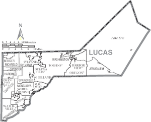
Adjacent counties
- Monroe County, MichiganMonroe County, MichiganMonroe County is a county in the U.S. state of Michigan. According to the U.S. Census Bureau, the 2010 population is 152,021. The largest city and county seat is Monroe. The U.S. Census Bureau defines all of Monroe County as conterminous with the Monroe Metropolitan Area...
(north) - Across Lake ErieLake ErieLake Erie is the fourth largest lake of the five Great Lakes in North America, and the tenth largest globally. It is the southernmost, shallowest, and smallest by volume of the Great Lakes and therefore also has the shortest average water residence time. It is bounded on the north by the...
lies Essex County, OntarioEssex County, OntarioEssex County is a county and census division located in Southwestern Ontario and covers an area at the southernmost tip of Canada. The administrative seat is Essex...
(northeast) - Ottawa CountyOttawa County, OhioOttawa County is a county located in the state of Ohio, United States. As of the 2010 census, the population was 41,428. Its county seat is Port Clinton and is named either for the Ottawa Indians who lived there, or for an Indian word meaning "trader"....
(southeast) - Wood CountyWood County, OhioWood County is a county located in the state of Ohio, United States. As of the 2010 census, the population was 125,488. Its county seat is Bowling Green. The county was named for Captain Eleazer D. Wood, the engineer for General William Henry Harrison's army, who built Fort Meigs in the War of 1812...
(south) - Henry CountyHenry County, OhioHenry County is a county located in the state of Ohio, United States. As of the 2010 census, the population was 28,215. Its county seat is Napoleon and is named for Patrick Henry, the Virginian famous for his "give me liberty or give me death" speech....
(southwest) - Fulton CountyFulton County, OhioFulton County is a county located in the U.S. state of Ohio. As of 2010, the population was 42,698. Its county seat is Wauseon. Fulton County is named for Robert Fulton, inventor of the steamboat....
(west) - Lenawee County, MichiganLenawee County, Michigan-Demographics:As of the census of 2000, there were 98,890 people, 35,930 households, and 26,049 families residing in the county. The population density was 132 people per square mile . There were 39,769 housing units at an average density of 53 per square mile...
(northwest)
National protected areas
- Cedar Point National Wildlife RefugeCedar Point National Wildlife RefugeCedar Point National Wildlife Refuge was donated to the United States Fish and Wildlife Service in 1964 by the owners of the Cedar Point Shooting Club. Currently, the refuge consists of of marsh, divided into three pools...
- Ottawa National Wildlife RefugeOttawa National Wildlife RefugeThe Ottawa National Wildlife Refuge was established in 1961 to preserve habitat for migrating birds. Staff at the refuge also manage Cedar Point and West Sister Island refuges...
(part) - West Sister Island National Wildlife Refuge
Demographics
As of the censusCensus
A census is the procedure of systematically acquiring and recording information about the members of a given population. It is a regularly occurring and official count of a particular population. The term is used mostly in connection with national population and housing censuses; other common...
of 2000, there were 455,054 people, 182,847 households, and 116,290 families residing in the county. The population density
Population density
Population density is a measurement of population per unit area or unit volume. It is frequently applied to living organisms, and particularly to humans...
was 1,337 people per square mile (516/km²). There were 196,259 housing units at an average density of 576 per square mile (223/km²). The racial makeup of the county was 77.50% White
Race (United States Census)
Race and ethnicity in the United States Census, as defined by the Federal Office of Management and Budget and the United States Census Bureau, are self-identification data items in which residents choose the race or races with which they most closely identify, and indicate whether or not they are...
, 16.98% Black
Race (United States Census)
Race and ethnicity in the United States Census, as defined by the Federal Office of Management and Budget and the United States Census Bureau, are self-identification data items in which residents choose the race or races with which they most closely identify, and indicate whether or not they are...
or African American
Race (United States Census)
Race and ethnicity in the United States Census, as defined by the Federal Office of Management and Budget and the United States Census Bureau, are self-identification data items in which residents choose the race or races with which they most closely identify, and indicate whether or not they are...
, 0.26% Native American
Race (United States Census)
Race and ethnicity in the United States Census, as defined by the Federal Office of Management and Budget and the United States Census Bureau, are self-identification data items in which residents choose the race or races with which they most closely identify, and indicate whether or not they are...
, 1.21% Asian
Race (United States Census)
Race and ethnicity in the United States Census, as defined by the Federal Office of Management and Budget and the United States Census Bureau, are self-identification data items in which residents choose the race or races with which they most closely identify, and indicate whether or not they are...
, 0.02% Pacific Islander
Race (United States Census)
Race and ethnicity in the United States Census, as defined by the Federal Office of Management and Budget and the United States Census Bureau, are self-identification data items in which residents choose the race or races with which they most closely identify, and indicate whether or not they are...
, 1.86% from other races
Race (United States Census)
Race and ethnicity in the United States Census, as defined by the Federal Office of Management and Budget and the United States Census Bureau, are self-identification data items in which residents choose the race or races with which they most closely identify, and indicate whether or not they are...
, and 2.16% from two or more races. 4.54% of the population were Hispanic
Race (United States Census)
Race and ethnicity in the United States Census, as defined by the Federal Office of Management and Budget and the United States Census Bureau, are self-identification data items in which residents choose the race or races with which they most closely identify, and indicate whether or not they are...
or Latino
Race (United States Census)
Race and ethnicity in the United States Census, as defined by the Federal Office of Management and Budget and the United States Census Bureau, are self-identification data items in which residents choose the race or races with which they most closely identify, and indicate whether or not they are...
of any race.
There were 182,847 households out of which 31.10% had children under the age of 18 living with them, 44.70% were married couples
Marriage
Marriage is a social union or legal contract between people that creates kinship. It is an institution in which interpersonal relationships, usually intimate and sexual, are acknowledged in a variety of ways, depending on the culture or subculture in which it is found...
living together, 14.70% had a female householder with no husband present, and 36.40% were non-families. 30.10% of all households were made up of individuals and 10.50% had someone living alone who was 65 years of age or older. The average household size was 2.44 and the average family size was 3.06.
In the county, the population was spread out with 26.30% under the age of 18, 9.80% from 18 to 24, 29.10% from 25 to 44, 21.70% from 45 to 64, and 13.10% who were 65 years of age or older. The median age was 35 years. For every 100 females there were 92.60 males. For every 100 females age 18 and over, there were 88.60 males.
The median income for a household in the county was $38,004, and the median income for a family was $48,190. Males had a median income of $39,415 versus $26,447 for females. The per capita income
Per capita income
Per capita income or income per person is a measure of mean income within an economic aggregate, such as a country or city. It is calculated by taking a measure of all sources of income in the aggregate and dividing it by the total population...
for the county was $20,518. About 10.70% of families and 13.90% of the population were below the poverty line, including 19.70% of those under age 18 and 8.70% of those age 65 or over.
History
On August 20, 1794, near the present-day town of MaumeeMaumee
Maumee may refer to:Places* Maumee, Indiana, an unincorporated community* Maumee, Ohio, a city in Lucas County* Maumee River, a river in northwestern Ohio and northeastern Indiana, United StatesGeology* Lake Maumee, the ancestor of present-day Lake Erie...
, American forces led by General Anthony Wayne won a decisive victory over Indian forces at the Battle of Fallen Timbers
Battle of Fallen Timbers
The Battle of Fallen Timbers was the final battle of the Northwest Indian War, a struggle between American Indian tribes affiliated with the Western Confederacy and the United States for control of the Northwest Territory...
. The battle opened the entire Northwest Territory
Northwest Territory
The Territory Northwest of the River Ohio, more commonly known as the Northwest Territory, was an organized incorporated territory of the United States that existed from July 13, 1787, until March 1, 1803, when the southeastern portion of the territory was admitted to the Union as the state of Ohio...
for white settlement.
Lucas County was formally organized in 1835. At that time, Ohio and Michigan Territory
Michigan Territory
The Territory of Michigan was an organized incorporated territory of the United States that existed from June 30, 1805, until January 26, 1837, when the final extent of the territory was admitted to the Union as the State of Michigan...
disputed the ownership of the strip of land along the border (see Toledo War
Toledo War
The Toledo War , also known as the Michigan-Ohio War, was the almost entirely bloodless boundary dispute between the U.S. state of Ohio and the adjoining territory of Michigan....
). As a move in the dispute, Ohio formally organized part of the disputed area as Lucas County, naming it after the incumbent governor
Governor
A governor is a governing official, usually the executive of a non-sovereign level of government, ranking under the head of state...
of Ohio, Robert Lucas
Robert Lucas (governor)
Robert Lucas was the 12th Governor of the U.S. state of Ohio, serving from 1832 to 1836. He served as the first Governor of Iowa Territory from 1838 to 1841.-Early life:...
.
Government
Politics
The county tends to be strongly Democratic in Presidential elections. Although Ronald ReaganRonald Reagan
Ronald Wilson Reagan was the 40th President of the United States , the 33rd Governor of California and, prior to that, a radio, film and television actor....
carried the county twice, no other Republican has won the county in the last 50 years. In the last five Presidential elections the Democratic candidate's margin of victory has ranged from 18% to 30.5% in the case of Barack Obama
Barack Obama
Barack Hussein Obama II is the 44th and current President of the United States. He is the first African American to hold the office. Obama previously served as a United States Senator from Illinois, from January 2005 until he resigned following his victory in the 2008 presidential election.Born in...
. As part of Ohio's 9th congressional district
Ohio's 9th congressional district
Ohio's 9th congressional district has been represented by Representative Marcia C. Kaptur since 1983.This district is in the northern part of the state, bordering Michigan and Ontario, Canada , and includes the counties of Erie, Lorain, Lucas, and Ottawa.-List of largest municipalities:All or part...
it is represented by Marcy Kaptur
Marcy Kaptur
Marcia Carolyn "Marcy" Kaptur is the U.S. Representative for , serving since 1983. She is a member of the Democratic Party. The district, anchored by the city of Toledo, includes all of Ottawa and Erie counties, and part of Lucas and Lorain counties.Serving her fourteenth term in the House of...
who is a member of the Congressional Progressive Caucus
Congressional Progressive Caucus
The Congressional Progressive Caucus is the largest caucus within the Democratic caucus in the United States Congress with 83 declared members, and works to advance progressive issues and positions....
.
Communities
Cities
|
Sylvania, Ohio As of the census of 2000, there were 18,670 people, 7,151 households, and 5,070 families residing in the city. The population density was 3,223.2 people per square mile . There were 7,392 housing units at an average density of 1,276.2 per square mile... Toledo, Ohio Toledo is the fourth most populous city in the U.S. state of Ohio and is the county seat of Lucas County. Toledo is in northwest Ohio, on the western end of Lake Erie, and borders the State of Michigan... |
Villages
|
Swanton, Ohio Swanton is a village in Fulton and Lucas counties in the U.S. state of Ohio. The population was 3,690 at the 2010 census.-History:A.D. Baker, a steam engine inventor, ran a machine shop in Swanton from 1901 to 1953.-Geography:... Waterville, Ohio Waterville is a village in Lucas County, Ohio, United States, along the Maumee River. The population was 4,828 at the 2000 census.-Geography:Waterville is located at .... Whitehouse, Ohio Whitehouse is a village in Lucas County, Ohio, United States. The population was 2,733 at the 2000 census.-Geography:Whitehouse is located at .... |
Townships
|
Providence Township, Lucas County, Ohio Providence Township is one of the eleven townships of Lucas County, Ohio, United States. The 2000 census found 3,454 people in the township.-Geography:... Richfield Township, Lucas County, Ohio Richfield Township is one of the eleven townships of Lucas County, Ohio, United States. The 2000 census found 1,573 people in the township, 1,308 of whom lived in the unincorporated portions of the township.-Geography:... Spencer Township, Lucas County, Ohio Spencer Township is one of the eleven townships of Lucas County, Ohio, United States. The 2000 census found 1,708 people in the township.-Geography:Located in the western part of the county, it borders the following townships:*Richfield Township - north... |
Springfield Township, Lucas County, Ohio Springfield Township is one of the eleven townships of Lucas County, Ohio, United States. As of 2000, the total population is 24,123, making it the third most populous part of Lucas County, behind Toledo and Sylvania Township. The township's population growth was up 20.3% between the 1990 and 2000... Swanton Township, Lucas County, Ohio Swanton Township is one of the eleven townships of Lucas County, Ohio, United States. The 2000 census found 3,354 people in the township, 3,330 of whom lived in the unincorporated portions of the township.-Geography:... Sylvania Township, Lucas County, Ohio Sylvania Township is one of the eleven townships of Lucas County, Ohio, United States. As of 2000, the total population was 44,253, making it the second most populous county subdivision of Lucas County, as well as the third most populous in all of northwest Ohio and the 419 / 567 area codes... |
Washington Township, Lucas County, Ohio Washington Township is one of the eleven townships of Lucas County, Ohio, United States. The 2000 census found 3,574 people in the township.-Geography:Most of what was once Washington Township is now incorporated municipality, leaving only two small pieces... Waterville Township, Lucas County, Ohio Waterville Township is one of the eleven townships of Lucas County, Ohio, United States. The 2000 census found 9,469 people in the township, 1,908 of whom lived in the unincorporated portions of the township.-Geography:... |
Other communities
|
Curtice, Ohio Curtice is a census-designated place in northern Allen Township, Ottawa County and southwestern Jerusalem Township, Lucas County, Ohio, United States. Although it is unincorporated, it has a post office, with the ZIP code of 43412.-References:... |
Monclova, Ohio Monclova is an unincorporated community in central Monclova Township, Lucas County, Ohio, United States. Although it is unincorporated, it has a post office, with the ZIP code of 43542.... Neapolis, Ohio Neapolis is a census-designated place in northwestern Providence Township, Lucas County, Ohio. Although it is unincorporated, it has a post office, with the ZIP code of 43547.... |
|
Major highways
 Interstate 75Interstate 75Interstate 75 is a major north–south Interstate Highway in the Great Lakes and Southeastern regions of the United States. It travels from State Road 826 and State Road 924 in Hialeah, Florida to Sault Ste. Marie, Michigan, at the Ontario, Canada, border...
 Interstate 80Interstate 80Interstate 80 is the second-longest Interstate Highway in the United States, following Interstate 90. It is a transcontinental artery running from downtown San Francisco, California to Teaneck, New Jersey in the New York City Metropolitan Area...
 Interstate 90Interstate 90Interstate 90 is the longest Interstate Highway in the United States at . It is the northernmost coast-to-coast interstate, and parallels US 20 for the most part. Its western terminus is in Seattle, at Edgar Martinez Drive S. near Safeco Field and CenturyLink Field, and its eastern terminus is in...
 Interstate 280Interstate 280 (Ohio)Interstate 280 is a 12.41-mile-long highway that connects I-75 in northeast Toledo, Ohio with I-80/I-90 southeast of the city in northeastern Wood County, Ohio....
 Interstate 475Interstate 475 (Ohio)Interstate 475 is an Interstate Highway in Ohio that is a western bypass of Toledo. The southern terminus is I-75 near Perrysburg. The northern terminus is I-75 near downtown Toledo...
 U.S. Highway 20
 U.S. Highway 23
 U.S. Highway 24