
Huron County, Ohio
Encyclopedia
As of the census
of 2000, there were 59,487 people, 22,307 households, and 16,217 families residing in the county. The population density
was 121 people per square mile (47/km²). There were 23,594 housing units at an average density of 48 per square mile (18/km²). The racial makeup of the county was 95.98% White
, 0.97% Black
or African American
, 0.18% Native American
, 0.25% Asian
, 0.01% Pacific Islander
, 1.63% from other races
, and 0.99% from two or more races. 3.56% of the population were Hispanic
or Latino
of any race.
There were 22,307 households out of which 36.30% had children under the age of 18 living with them, 58.50% were married couples
living together, 10.40% had a female householder with no husband present, and 27.30% were non-families. 23.10% of all households were made up of individuals and 9.70% had someone living alone who was 65 years of age or older. The average household size was 2.64 and the average family size was 3.11.
In the county, the population was spread out with 28.30% under the age of 18, 8.50% from 18 to 24, 28.90% from 25 to 44, 21.90% from 45 to 64, and 12.40% who were 65 years of age or older. The median age was 35 years. For every 100 females there were 96.10 males. For every 100 females age 18 and over, there were 92.90 males.
The median income for a household in the county was $40,558, and the median income for a family was $46,911. Males had a median income of $35,760 versus $22,785 for females. The per capita income
for the county was $18,133. About 6.50% of families and 8.50% of the population were below the poverty line, including 11.00% of those under age 18 and 7.70% of those age 65 or over.
Commissioner - Joe Hintz
Commissioner - Larry J. Silcox
Auditor - Roland Tkach
Clerk of Courts - Susan Hazel
Coroner - Jeffery Harwood
Engineer - Joseph B. Kovach
Prosecutor - Russel Leffler
Recorder - Karen Fries
Treasurer - Kathleen Schaffer
Sheriff - Dane Howard
Judge of Court of Common Pleas - James Conway
Court Secretary (non-elected position) - Julie Wise
Census
A census is the procedure of systematically acquiring and recording information about the members of a given population. It is a regularly occurring and official count of a particular population. The term is used mostly in connection with national population and housing censuses; other common...
of 2000, there were 59,487 people, 22,307 households, and 16,217 families residing in the county. The population density
Population density
Population density is a measurement of population per unit area or unit volume. It is frequently applied to living organisms, and particularly to humans...
was 121 people per square mile (47/km²). There were 23,594 housing units at an average density of 48 per square mile (18/km²). The racial makeup of the county was 95.98% White
Race (United States Census)
Race and ethnicity in the United States Census, as defined by the Federal Office of Management and Budget and the United States Census Bureau, are self-identification data items in which residents choose the race or races with which they most closely identify, and indicate whether or not they are...
, 0.97% Black
Race (United States Census)
Race and ethnicity in the United States Census, as defined by the Federal Office of Management and Budget and the United States Census Bureau, are self-identification data items in which residents choose the race or races with which they most closely identify, and indicate whether or not they are...
or African American
Race (United States Census)
Race and ethnicity in the United States Census, as defined by the Federal Office of Management and Budget and the United States Census Bureau, are self-identification data items in which residents choose the race or races with which they most closely identify, and indicate whether or not they are...
, 0.18% Native American
Race (United States Census)
Race and ethnicity in the United States Census, as defined by the Federal Office of Management and Budget and the United States Census Bureau, are self-identification data items in which residents choose the race or races with which they most closely identify, and indicate whether or not they are...
, 0.25% Asian
Race (United States Census)
Race and ethnicity in the United States Census, as defined by the Federal Office of Management and Budget and the United States Census Bureau, are self-identification data items in which residents choose the race or races with which they most closely identify, and indicate whether or not they are...
, 0.01% Pacific Islander
Race (United States Census)
Race and ethnicity in the United States Census, as defined by the Federal Office of Management and Budget and the United States Census Bureau, are self-identification data items in which residents choose the race or races with which they most closely identify, and indicate whether or not they are...
, 1.63% from other races
Race (United States Census)
Race and ethnicity in the United States Census, as defined by the Federal Office of Management and Budget and the United States Census Bureau, are self-identification data items in which residents choose the race or races with which they most closely identify, and indicate whether or not they are...
, and 0.99% from two or more races. 3.56% of the population were Hispanic
Race (United States Census)
Race and ethnicity in the United States Census, as defined by the Federal Office of Management and Budget and the United States Census Bureau, are self-identification data items in which residents choose the race or races with which they most closely identify, and indicate whether or not they are...
or Latino
Race (United States Census)
Race and ethnicity in the United States Census, as defined by the Federal Office of Management and Budget and the United States Census Bureau, are self-identification data items in which residents choose the race or races with which they most closely identify, and indicate whether or not they are...
of any race.
There were 22,307 households out of which 36.30% had children under the age of 18 living with them, 58.50% were married couples
Marriage
Marriage is a social union or legal contract between people that creates kinship. It is an institution in which interpersonal relationships, usually intimate and sexual, are acknowledged in a variety of ways, depending on the culture or subculture in which it is found...
living together, 10.40% had a female householder with no husband present, and 27.30% were non-families. 23.10% of all households were made up of individuals and 9.70% had someone living alone who was 65 years of age or older. The average household size was 2.64 and the average family size was 3.11.
In the county, the population was spread out with 28.30% under the age of 18, 8.50% from 18 to 24, 28.90% from 25 to 44, 21.90% from 45 to 64, and 12.40% who were 65 years of age or older. The median age was 35 years. For every 100 females there were 96.10 males. For every 100 females age 18 and over, there were 92.90 males.
The median income for a household in the county was $40,558, and the median income for a family was $46,911. Males had a median income of $35,760 versus $22,785 for females. The per capita income
Per capita income
Per capita income or income per person is a measure of mean income within an economic aggregate, such as a country or city. It is calculated by taking a measure of all sources of income in the aggregate and dividing it by the total population...
for the county was $18,133. About 6.50% of families and 8.50% of the population were below the poverty line, including 11.00% of those under age 18 and 7.70% of those age 65 or over.
Government
Officials
Commissioner - Gary Bauer (President)Commissioner - Joe Hintz
Commissioner - Larry J. Silcox
Auditor - Roland Tkach
Clerk of Courts - Susan Hazel
Coroner - Jeffery Harwood
Engineer - Joseph B. Kovach
Prosecutor - Russel Leffler
Recorder - Karen Fries
Treasurer - Kathleen Schaffer
Sheriff - Dane Howard
Judge of Court of Common Pleas - James Conway
Court Secretary (non-elected position) - Julie Wise
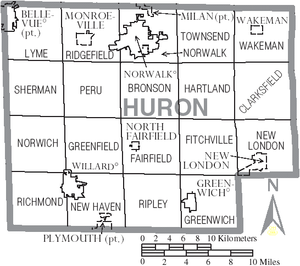
Communities
Villages
|
North Fairfield, Ohio North Fairfield is a village in Huron County, Ohio, United States. The population was 573 at the 2000 census.North Fairfield is served by a branch of the Willard Memorial Library.-Geography:North Fairfield is located at .... Plymouth, Ohio Plymouth is a village in Huron and Richland counties in the U.S. state of Ohio. The population was 1,852 at the 2000 census.The Richland County portion of Plymouth is part of the Mansfield Metropolitan Statistical Area, while the Huron County portion is part of the Norwalk Micropolitan Statistical... Wakeman, Ohio Wakeman is a village in Huron County, Ohio, United States, along the Vermilion River and is named after Jesup Wakeman, an early settler of Fairfield County, Connecticut, who was involved in western land speculation between 1800 and 1840.... |
Townships
|
Greenwich Township, Huron County, Ohio Greenwich Township is one of the nineteen townships of Huron County, Ohio, United States. The 2000 census found 954 people in the township.-Geography:Located on the southern edge of the county, it borders the following townships:... Hartland Township, Huron County, Ohio Hartland Township is one of the nineteen townships of Huron County, Ohio, United States. The 2000 census found 979 people in the township.-Geography:Located in the eastern part of the county, it borders the following townships:*Townsend Township - north... Lyme Township, Huron County, Ohio Lyme Township is one of the nineteen townships of Huron County, Ohio, United States. The 2000 census found 968 people in the township.-Geography:Located in the northwestern corner of the county, it borders the following townships:... New Haven Township, Huron County, Ohio New Haven Township is one of the nineteen townships of Huron County, Ohio, United States. The 2000 census found 2,860 people in the township, 2,011 of whom lived in the unincorporated portions of the township.-Geography:... New London Township, Huron County, Ohio New London Township is one of the nineteen townships of Huron County, Ohio, United States. The 2000 census found 3,440 people in the township, 744 of whom lived in the unincorporated portions of the township.-Geography:... |
Norwalk Township, Huron County, Ohio Norwalk Township is one of the nineteen townships of Huron County, Ohio, United States. The 2000 census found 3,685 people in the township, 3,265 of whom lived in the unincorporated portions of the township.-Geography:... Norwich Township, Huron County, Ohio Norwich Township is one of the nineteen townships of Huron County, Ohio, United States. The 2000 census found 1,072 people in the township.-Geography:Located on the western edge of the county, it borders the following townships:*Sherman Township - north... Peru Township, Huron County, Ohio Peru Township is one of the nineteen townships of Huron County, Ohio, United States. The 2000 census found 1,043 people in the township.-Geography:Located in the western part of the county, it borders the following townships:*Ridgefield Township - north... Richmond Township, Huron County, Ohio Richmond Township is one of the nineteen townships of Huron County, Ohio, United States. The 2000 census found 1,111 people in the township.-Geography:Located in the southwestern corner of the county, it borders the following townships:... Ridgefield Township, Huron County, Ohio Ridgefield Township is one of the nineteen townships of Huron County, Ohio, United States. The 2000 census found 2,390 people in the township, 957 of whom lived in the unincorporated portions of the township.-Geography:... |
Ripley Township, Huron County, Ohio Ripley Township is one of the nineteen townships of Huron County, Ohio, United States. The 2000 census found 943 people in the township.-Geography:Located on the southern edge of the county, it borders the following townships:*Fairfield Township - north... Sherman Township, Huron County, Ohio Sherman Township is one of the nineteen townships of Huron County, Ohio, United States. The 2000 census found 501 people in the township.-Geography:Located on the western edge of the county, it borders the following townships:*Lyme Township - north... Townsend Township, Huron County, Ohio Townsend Township is one of the nineteen townships of Huron County, Ohio, United States. The 2000 census found 1,567 people in the township.-Geography:Located on the northern edge of the county, it borders the following townships:... Wakeman Township, Huron County, Ohio Wakeman Township is one of the nineteen townships of Huron County, Ohio, United States. The 2000 census found 2,528 people in the township, 1,577 of whom lived in the unincorporated portions of the township.-Geography:... |
Unincorporated communities
|
Hunts Corners, Ohio Hunts Corners is an unincorporated community in southeastern Lyme Township, Huron County, Ohio, United States. It lies at the intersection of State Route 547 and Sand Hill Road, southeast of Bellevue and southwest of the city of Norwalk, the county seat of Huron County... New Haven, Ohio New Haven is a census-designated place in central New Haven Township, Huron County, Ohio, United States. Although it is unincorporated, it has a post office, with the ZIP code of 44850. It lies at the intersection of U.S... |
Steuben, Ohio Steuben is an unincorporated village in central Greenfield Township, Huron County, Ohio, United States, located a few miles northeast of the village of Willard... |