
Logan County, Ohio
Encyclopedia
Logan County is a county in the state
of Ohio
, United States
. As of the 2010 census, the population was 45,858. http://quickfacts.census.gov/qfd/states/39/39091.html The county seat
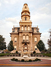
is Bellefontaine
. The county is named for Benjamin Logan
, who fought Native Americans
in the area.
The Bellefontaine Micropolitan Statistical Area includes all of Logan County.
 According to the U.S. Census Bureau
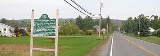
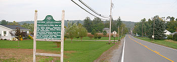
, the county has a total area of 467 square miles (1,209.5 km²).458 square miles (1,187 km²) of it is land and 8 square miles (20.7 km²) of it (1.79%) is water. 1549 feet (472.1 m) Campbell Hill, the highest natural point in Ohio, is located northeast of Bellefontaine.
As of the census
of 2000, there were 46,005 people, 17,956 households, and 12,730 families residing in the county. The population density
was 100 people per square mile (39/km²). There were 21,571 housing units at an average density of 47 per square mile (18/km²). The racial makeup of the county was 96.15% White
, 1.71% Black
or African American
, 0.20% Native American
, 0.40% Asian
, 0.03% Pacific Islander
, 0.27% from other races
, and 1.24% from two or more races. 0.72% of the population were Hispanic
or Latino
of any race. 96.8% spoke English
, 1.0% German
and 1.0% Spanish
as their first language.
There were 17,956 households out of which 33.30% had children under the age of 18 living with them, 57.00% were married couples
living together, 9.50% had a female householder with no husband present, and 29.10% were non-families. 24.80% of all households were made up of individuals and 10.30% had someone living alone who was 65 years of age or older. The average household size was 2.53 and the average family size was 3.01.
In the county, the population was spread out with 26.70% under the age of 18, 8.20% from 18 to 24, 27.90% from 25 to 44, 23.30% from 45 to 64, and 13.90% who were 65 years of age or older. The median age was 37 years. For every 100 females there were 96.10 males. For every 100 females age 18 and over, there were 93.60 males.
The median income for a household in the county was $41,479, and the median income for a family was $47,516. Males had a median income of $37,134 versus $24,739 for females. The per capita income
for the county was $18,984. About 7.10% of families and 9.30% of the population were below the poverty line, including 11.80% of those under age 18 and 8.50% of those age 65 or over.

U.S. state
A U.S. state is any one of the 50 federated states of the United States of America that share sovereignty with the federal government. Because of this shared sovereignty, an American is a citizen both of the federal entity and of his or her state of domicile. Four states use the official title of...
of Ohio
Ohio
Ohio is a Midwestern state in the United States. The 34th largest state by area in the U.S.,it is the 7th‑most populous with over 11.5 million residents, containing several major American cities and seven metropolitan areas with populations of 500,000 or more.The state's capital is Columbus...
, United States
United States
The United States of America is a federal constitutional republic comprising fifty states and a federal district...
. As of the 2010 census, the population was 45,858. http://quickfacts.census.gov/qfd/states/39/39091.html The county seat
County seat
A county seat is an administrative center, or seat of government, for a county or civil parish. The term is primarily used in the United States....
is Bellefontaine
Bellefontaine, Ohio
Bellefontaine is a city in and the county seat of Logan County, Ohio, United States. The population was 13,069 at the 2000 census. It is the center of the Bellefontaine Micropolitan Statistical Area, as defined by the United States Census Bureau in 2003...
. The county is named for Benjamin Logan
Benjamin Logan
Benjamin Logan was an American pioneer, soldier, and politician from Shelby County, Kentucky. As colonel of the Kentucky County militia of Virginia during the American Revolutionary War, he was second-in-command of militia in Kentucky. Logan was a leader in Kentucky's efforts to become a state...
, who fought Native Americans
Native Americans in the United States
Native Americans in the United States are the indigenous peoples in North America within the boundaries of the present-day continental United States, parts of Alaska, and the island state of Hawaii. They are composed of numerous, distinct tribes, states, and ethnic groups, many of which survive as...
in the area.
The Bellefontaine Micropolitan Statistical Area includes all of Logan County.
Geography
United States Census Bureau
The United States Census Bureau is the government agency that is responsible for the United States Census. It also gathers other national demographic and economic data...
, the county has a total area of 467 square miles (1,209.5 km²).458 square miles (1,187 km²) of it is land and 8 square miles (20.7 km²) of it (1.79%) is water. 1549 feet (472.1 m) Campbell Hill, the highest natural point in Ohio, is located northeast of Bellefontaine.
Adjacent counties
- Hardin CountyHardin County, OhioHardin County is a county located in the state of Ohio, United States. As of the 2010 census, the population was 32,058. Its county seat is Kenton and is named for John Hardin, an officer in the American Revolution.-Geography:According to the U.S...
(north) - Union CountyUnion County, OhioUnion County is a county located in the US state of Ohio. As of the 2010 census, the population was 52,300. Increasingly becoming more of a suburban county, the population was estimated at 47,234 in 2007 by the U.S. Census Bureau...
(east) - Champaign CountyChampaign County, OhioAs of the census of 2000, there were 38,890 people, 14,952 households, and 10,870 families residing in the county. The population density was 91 people per square mile . There were 15,890 housing units at an average density of 37 per square mile...
(south) - Shelby CountyShelby County, OhioAs of the census of 2000, there were 47,910 people, 17,636 households, and 13,085 families residing in the county. The population density was 117 people per square mile . There were 18,682 housing units at an average density of 46 per square mile...
(west) - Auglaize CountyAuglaize County, OhioAs of the census of 2000, there were 46,611 people, 17,376 households, and 12,771 families residing in the county. The population density was 116 people per square mile . There were 18,470 housing units at an average density of 46 per square mile...
(northwest)
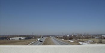
Major highways
 U.S. Route 33U.S. Route 33U.S. Route 33 is a United States federal highway that runs northwest-southeast for 709 miles from northern Indiana to Richmond, Virginia, passing through Ohio and West Virginia en route. Although most odd-numbered U.S...
 U.S. Route 68U.S. Route 68U.S. Route 68 is an east–west United States highway that runs for from northwest Ohio to western Kentucky. The highway's western terminus is at U.S. Route 62 in Reidland, Kentucky. Its eastern terminus is at Interstate 75 in Findlay, Ohio...
 State Route 47Ohio State Route 47Ohio State Route 47 is a state highway running from the Indiana border at Union City to Waldo, about ten miles south of Marion. In Bellefontaine, State Route 47 follows the path of different streets from Main Street and Sandusky Avenue to the intersection just north of Mary Rutan Hospital, about...
 State Route 117
 State Route 235
 State Route 245
 State Route 273Ohio State Route 273State Route 273 is a two-lane east–west state highway in Logan and Hardin counties in the U.S. state of Ohio. It begins at an intersection with State Route 31 in Mt. Victory, passes through Belle Center, and ends in a dead end on Long Island at Indian Lake...
 State Route 274Ohio State Route 274State Route 274 is a two-lane east–west state highway located in the western portion of the U.S. state of Ohio. The western terminus of State Route 274 is at a T-intersection with U.S. Route 127 approximately west of Chickasaw...
 State Route 287
 State Route 292Ohio State Route 292State Route 292 is a two-lane north–south state highway in the western portion of the U.S. state of Ohio. The southern terminus of the highway is at a diamond interchange with the U.S. Route 33 expressway approximately southeast of the village of Zanesfield...
 State Route 347Ohio State Route 347State Route 347 is an east–west state highway in central portion of the U.S. state of Ohio. The western terminus of SR 347 is at an interchange with U.S. Route 33 just south of the unincorporated community of East Liberty...
 State Route 365
 State Route 366
 State Route 368
 State Route 508
 State Route 533
 State Route 540
 State Route 559Ohio State Route 559State Route 559 is a north–south state highway in the central portion of the U.S. state of Ohio. The southern terminus of the highway is at the signalized junction of State Route 29 and State Route 4 in downtown Mechanicsburg...
 State Route 706Ohio State Route 706Ohio State Route 706 ' is an east–west state route in western Ohio. The western terminus of OH 706 is at OH 29 in the hamlet of Pasco, and its eastern terminus is at a T-intersection with OH 235 just south of Quincy. - Route description :...
 State Route 708
 State Route 720Ohio State Route 720State Route 720 is an east–west state highway in the western portion of the U.S. state of Ohio. The highway runs from its western terminus at State Route 65 approximately north of Jackson Center to its eastern terminus at U.S. Route 33 in Russells Point.State Route 720 made its debut in...
Demographics
As of the census
Census
A census is the procedure of systematically acquiring and recording information about the members of a given population. It is a regularly occurring and official count of a particular population. The term is used mostly in connection with national population and housing censuses; other common...
of 2000, there were 46,005 people, 17,956 households, and 12,730 families residing in the county. The population density
Population density
Population density is a measurement of population per unit area or unit volume. It is frequently applied to living organisms, and particularly to humans...
was 100 people per square mile (39/km²). There were 21,571 housing units at an average density of 47 per square mile (18/km²). The racial makeup of the county was 96.15% White
Race (United States Census)
Race and ethnicity in the United States Census, as defined by the Federal Office of Management and Budget and the United States Census Bureau, are self-identification data items in which residents choose the race or races with which they most closely identify, and indicate whether or not they are...
, 1.71% Black
Race (United States Census)
Race and ethnicity in the United States Census, as defined by the Federal Office of Management and Budget and the United States Census Bureau, are self-identification data items in which residents choose the race or races with which they most closely identify, and indicate whether or not they are...
or African American
Race (United States Census)
Race and ethnicity in the United States Census, as defined by the Federal Office of Management and Budget and the United States Census Bureau, are self-identification data items in which residents choose the race or races with which they most closely identify, and indicate whether or not they are...
, 0.20% Native American
Race (United States Census)
Race and ethnicity in the United States Census, as defined by the Federal Office of Management and Budget and the United States Census Bureau, are self-identification data items in which residents choose the race or races with which they most closely identify, and indicate whether or not they are...
, 0.40% Asian
Race (United States Census)
Race and ethnicity in the United States Census, as defined by the Federal Office of Management and Budget and the United States Census Bureau, are self-identification data items in which residents choose the race or races with which they most closely identify, and indicate whether or not they are...
, 0.03% Pacific Islander
Race (United States Census)
Race and ethnicity in the United States Census, as defined by the Federal Office of Management and Budget and the United States Census Bureau, are self-identification data items in which residents choose the race or races with which they most closely identify, and indicate whether or not they are...
, 0.27% from other races
Race (United States Census)
Race and ethnicity in the United States Census, as defined by the Federal Office of Management and Budget and the United States Census Bureau, are self-identification data items in which residents choose the race or races with which they most closely identify, and indicate whether or not they are...
, and 1.24% from two or more races. 0.72% of the population were Hispanic
Race (United States Census)
Race and ethnicity in the United States Census, as defined by the Federal Office of Management and Budget and the United States Census Bureau, are self-identification data items in which residents choose the race or races with which they most closely identify, and indicate whether or not they are...
or Latino
Race (United States Census)
Race and ethnicity in the United States Census, as defined by the Federal Office of Management and Budget and the United States Census Bureau, are self-identification data items in which residents choose the race or races with which they most closely identify, and indicate whether or not they are...
of any race. 96.8% spoke English
English language
English is a West Germanic language that arose in the Anglo-Saxon kingdoms of England and spread into what was to become south-east Scotland under the influence of the Anglian medieval kingdom of Northumbria...
, 1.0% German
German language
German is a West Germanic language, related to and classified alongside English and Dutch. With an estimated 90 – 98 million native speakers, German is one of the world's major languages and is the most widely-spoken first language in the European Union....
and 1.0% Spanish
Spanish language
Spanish , also known as Castilian , is a Romance language in the Ibero-Romance group that evolved from several languages and dialects in central-northern Iberia around the 9th century and gradually spread with the expansion of the Kingdom of Castile into central and southern Iberia during the...
as their first language.
There were 17,956 households out of which 33.30% had children under the age of 18 living with them, 57.00% were married couples
Marriage
Marriage is a social union or legal contract between people that creates kinship. It is an institution in which interpersonal relationships, usually intimate and sexual, are acknowledged in a variety of ways, depending on the culture or subculture in which it is found...
living together, 9.50% had a female householder with no husband present, and 29.10% were non-families. 24.80% of all households were made up of individuals and 10.30% had someone living alone who was 65 years of age or older. The average household size was 2.53 and the average family size was 3.01.
In the county, the population was spread out with 26.70% under the age of 18, 8.20% from 18 to 24, 27.90% from 25 to 44, 23.30% from 45 to 64, and 13.90% who were 65 years of age or older. The median age was 37 years. For every 100 females there were 96.10 males. For every 100 females age 18 and over, there were 93.60 males.
The median income for a household in the county was $41,479, and the median income for a family was $47,516. Males had a median income of $37,134 versus $24,739 for females. The per capita income
Per capita income
Per capita income or income per person is a measure of mean income within an economic aggregate, such as a country or city. It is calculated by taking a measure of all sources of income in the aggregate and dividing it by the total population...
for the county was $18,984. About 7.10% of families and 9.30% of the population were below the poverty line, including 11.80% of those under age 18 and 8.50% of those age 65 or over.
Communities
Villages
|
Quincy, Ohio Quincy is a village in Logan County, Ohio, United States. The population was 734 at the 2000 census.-Geography:Quincy is located at .According to the United States Census Bureau, the village has a total area of , all of it land.... Ridgeway, Ohio Ridgeway is a village in Hardin and Logan counties in the U.S. state of Ohio. The population was 354 at the 2000 census.-Geography:Ridgeway is located at .... Rushsylvania, Ohio Rushsylvania is a village located in Logan County, Ohio, United States. The population was 543 at the 2000 census.A branch of the Logan County District Library serves the Rushsylvania community.-Geography:... Russells Point, Ohio Russells Point is a village located in Logan County, Ohio, United States. The population was 1,619 at the 2000 census. It is situated on Indian Lake.-Geography:Russells Point is located at .... |
Valley Hi, Ohio Valley Hi is a village in Logan County, Ohio, United States. The population was 244 at the 2000 census. The village is located nearby U.S. Route 33 and is about an hour northwest of Columbus.... West Liberty, Ohio West Liberty is a village in Logan County, Ohio, United States. The population was 1,813 at the 2000 census.-Geography:West Liberty is located at .... West Mansfield, Ohio West Mansfield is a village located in Logan County, Ohio, United States. The population was 700 at the 2000 census.A branch of the Logan County District Library serves the West Mansfield community.-Geography:West Mansfield is located at .... Zanesfield, Ohio Zanesfield is a village in Logan County, Ohio, United States of America. The population was 220 at the 2000 census. It is the smallest incorporated village in Logan County.-History:... |
Townships
|
McArthur Township, Logan County, Ohio McArthur Township is one of the seventeen townships of Logan County, Ohio, United States. The 2000 census found 1,949 people in the township.-Geography:Located in the northern part of the county, it borders the following townships:*Richland Township - north... Miami Township, Logan County, Ohio Miami Township is one of the seventeen townships of Logan County, Ohio, United States. The 2000 census found 2,352 people in the township.-Geography:Located in the southwestern corner of the county, it borders the following townships:... Monroe Township, Logan County, Ohio Monroe Township is one of the seventeen townships of Logan County, Ohio, United States. The 2000 census found 1,503 people in the township.-Geography:Located in the southeastern part of the county, it borders the following townships:... Perry Township, Logan County, Ohio Perry Township is one of the seventeen townships of Logan County, Ohio, United States. The 2000 census found 1,022 people in the township.-Geography:Located in the eastern part of the county, it borders the following townships:*Bokes Creek Township - north... Pleasant Township, Logan County, Ohio Pleasant Township is one of the seventeen townships of Logan County, Ohio, United States. The 2000 census found 1,082 people in the township.-Geography:Located in the southwestern part of the county, it borders the following townships:... Richland Township, Logan County, Ohio Richland Township is one of the seventeen townships of Logan County, Ohio, United States. The 2000 census found 2,455 people in the township.-Geography:Located in the northern part of the county, it borders the following townships:... |
Rushcreek Township, Logan County, Ohio Rushcreek Township is one of the seventeen townships of Logan County, Ohio, United States. The 2000 census found 2,191 people in the township.-Geography:Located in the northeastern part of the county, it borders the following townships:... Stokes Township, Logan County, Ohio Stokes Township is one of the seventeen townships of Logan County, Ohio, United States. The 2000 census found 5,367 people in the township.-Geography:Located in the northwestern corner of the county, it borders the following townships:... Union Township, Logan County, Ohio Union Township is one of the seventeen townships of Logan County, Ohio, United States. The 2000 census found 787 people in the township.-Geography:Located in the southwestern part of the county, it borders the following townships:*Harrison Township - north... Washington Township, Logan County, Ohio Washington Township is one of the seventeen townships of Logan County, Ohio, United States. The 2000 census found 3,945 people in the township.-Geography:Located in the western part of the county, it borders the following townships:... Zane Township, Logan County, Ohio Zane Township is one of the seventeen townships of Logan County, Ohio, United States. The 2000 census found 968 people in the township.-Geography:Located in the southeastern corner of the county, it borders the following townships:*Perry Township - north... |
Census-designated places
|
Lewistown, Ohio Lewistown is a census-designated place in central Washington Township, Logan County, Ohio, United States. Until the 1829 Treaty of Lewistown, the community was the site of a Shawnee settlement. It said to have been named in honor of “Captain” John Lewis, a Shawnee leader... Orchard Island, Ohio Orchard Island is a residential and tourist census-designated place located in Washington and Stokes Townships, Logan County, Ohio, United States.-Location:... |
Unincorporated communities
|
Logansville, Ohio Logansville is an unincorporated community in central Pleasant Township, Logan County, Ohio, United States. It lies along State Route 47 at its intersection with County Road 24. The Great Miami River flows southward along the western edge of Logansville... |
Northwood, Logan County, Ohio Northwood is a small, unincorporated crossroads village in northern Logan County, Ohio, United States. It lies along the line between Richland Township and McArthur Township, approximately two miles south of the village of Belle Center and near the South Fork of the Great Miami River. Northwood... Pickrelltown, Ohio Pickrelltown is an unincorporated community located at the intersection of two roads in northern Monroe Township, Logan County, Ohio, United States. It has also been known as Frogtown, and its current name has also been spelled Pickereltown, Pickeretown, and Pickreltown... |
Santa Fe, Ohio Santa Fe is an unincorporated community located on the border of Clay Township in Auglaize County and Stokes Township in Logan County, in the west central part of the U.S. state of Ohio.... |
Notable residents
- George BartholomewGeorge BartholomewGeorge Bartholomew was an American inventor who is credited with the invention of concrete pavement. In 1886, Bartholomew moved to Bellefontaine, Ohio, after having learned about cement production. Bartholomew found a good source of limestone and clay in the area; from this, he hoped to create an...
- inventor - Blue Jacket (Weyapiersenwah)Blue JacketBlue Jacket or Weyapiersenwah was a war chief of the Shawnee people, known for his militant defense of Shawnee lands in the Ohio Country...
- ShawneeShawneeThe Shawnee, Shaawanwaki, Shaawanooki and Shaawanowi lenaweeki, are an Algonquian-speaking people native to North America. Historically they inhabited the areas of Ohio, Virginia, West Virginia, Western Maryland, Kentucky, Indiana, and Pennsylvania...
chief - Bethany DillonBethany DillonBethany Dillon is a Contemporary Christian music artist. She is now married to contemporary Christian recording artist Shane Barnard of Shane & Shane.-Childhood:...
- singer; nominee for 2004 Gospel Music AssociationGospel Music AssociationThe Gospel Music Association was founded in 1964 for the purpose of supporting and promoting the development of all forms of Gospel music. There are currently about 4,000 members worldwide...
New Artist of the Year award - Allan W. EckertAllan W. EckertAllan W. Eckert was an American historian, historical novelist, and naturalist.-Biography:Eckert was born in Buffalo, New York and raised in the Chicago, Illinois area, but had been a long-time resident of Bellefontaine, Ohio, near where he attended university...
- author - Jim FloraJim FloraJames "Jim" Flora , best known for his distinctive and idiosyncratic album cover art for RCA Victor and Columbia Records during the 1940s and 1950s, was also a prolific commercial illustrator from the 1940s to the 1970s and the author/illustrator of 17 popular children's books...
- artist - Melville J. HerskovitsMelville J. HerskovitsMelville Jean Herskovits was an American anthropologist who firmly established African and African American studies in American academia. The son of Jewish immigrants, he obtained a Bachelor of Philosophy at the University of Chicago in 1923 and obtained his Master's and Ph.D...
- anthropologist - Kin HubbardKin HubbardFrank McKinney Hubbard was an American cartoonist, humorist, and journalist better known by his pen name "Kin" Hubbard....
- cartoonist and journalist - Edward D. JonesEdward D. JonesEdward D. Jones, Sr. was an investment banker born in St. Louis, Missouri. He graduated from Bellefontaine High School in Bellefontaine, Ohio in 1913, then from New York University in 1916....
- investment bankerInvestment bankingAn investment bank is a financial institution that assists individuals, corporations and governments in raising capital by underwriting and/or acting as the client's agent in the issuance of securities... - Austin Eldon KnowltonAustin Eldon KnowltonAustin Eldon Knowlton was trained as an architect but spent most of his career in the construction industry. His company designed, financed and built more than 160 college and university buildings on every major college campus in Ohio and more than 200 elementary and secondary school buildings...
- architect - William Lawrence - RepublicanRepublican Party (United States)The Republican Party is one of the two major contemporary political parties in the United States, along with the Democratic Party. Founded by anti-slavery expansion activists in 1854, it is often called the GOP . The party's platform generally reflects American conservatism in the U.S...
politician involved with the attempt to impeach Andrew JohnsonAndrew JohnsonAndrew Johnson was the 17th President of the United States . As Vice-President of the United States in 1865, he succeeded Abraham Lincoln following the latter's assassination. Johnson then presided over the initial and contentious Reconstruction era of the United States following the American...
, creating the United States Department of JusticeUnited States Department of JusticeThe United States Department of Justice , is the United States federal executive department responsible for the enforcement of the law and administration of justice, equivalent to the justice or interior ministries of other countries.The Department is led by the Attorney General, who is nominated...
, helping to create the American Red CrossAmerican Red CrossThe American Red Cross , also known as the American National Red Cross, is a volunteer-led, humanitarian organization that provides emergency assistance, disaster relief and education inside the United States. It is the designated U.S...
, and ratifying the Geneva Convention - The Mills BrothersMills BrothersThe Mills Brothers, sometimes billed as The Four Mills Brothers, were an American jazz and pop vocal quartet of the 20th century who made more than 2,000 recordings that combined sold more than 50 million copies, and garnered at least three dozen gold records...
- entertainers - Norman Vincent PealeNorman Vincent PealeDr. Norman Vincent Peale was a minister and author and a progenitor of the theory of "positive thinking".-Early life and education:...
- minister and author