
Crawford County, Ohio
Encyclopedia
Crawford County is a county located in the state
of Ohio
, United States
. It was named for Colonel William Crawford
, a soldier during the American Revolution.
As of 2010, the population was 43,784. http://quickfacts.census.gov/qfd/states/39/39033.html Its county seat
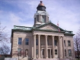
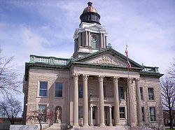
is Bucyrus
. The Bucyrus Micropolitan Statistical Area includes all of Crawford County.
, the county has a total area of 403 square miles (1,043.8 km²).402 square miles (1,041.2 km²) is land and 1 square miles (2.6 km²) (0.18%) is water.
The county is drained by the Sandusky
and Olentangy
Rivers.
of 2000, there were 46,966 people, 18,957 households, and 13,175 families residing in the county. The population density
was 117 people per square mile (45/km²). There were 20,178 housing units at an average density of 50 per square mile (19/km²). The racial makeup of the county was 97.99% White
, 0.59% Black
or African American
, 0.20% Native American
, 0.31% Asian
, 0.02% Pacific Islander
, 0.24% from other races
, and 0.65% from two or more races. 0.77% of the population were Hispanic
or Latino
of any race. 40.4% were of German
, 21.4% American
, 8.1% English
and 7.8% Irish
ancestry according to Census 2000.
 There were 18,957 households out of which 31.20% had children under the age of 18 living with them, 55.10% were married couples
living together, 10.50% had a female householder with no husband present, and 30.50% were non-families. 26.30% of all households were made up of individuals and 11.50% had someone living alone who was 65 years of age or older. The average household size was 2.45 and the average family size was 2.94.
In the county the population was spread out with 24.90% under the age of 18, 8.00% from 18 to 24, 27.60% from 25 to 44, 24.30% from 45 to 64, and 15.20% who were 65 years of age or older. The median age was 38 years. For every 100 females there were 93.40 males. For every 100 females age 18 and over, there were 90.80 males.
The median income for a household in the county was $36,227, and the median income for a family was $43,169. Males had a median income of $33,319 versus $21,346 for females. The per capita income
for the county was $17,466. About 7.80% of families and 10.40% of the population were below the poverty line, including 13.70% of those under age 18 and 7.50% of those age 65 or over.
U.S. state
A U.S. state is any one of the 50 federated states of the United States of America that share sovereignty with the federal government. Because of this shared sovereignty, an American is a citizen both of the federal entity and of his or her state of domicile. Four states use the official title of...
of Ohio
Ohio
Ohio is a Midwestern state in the United States. The 34th largest state by area in the U.S.,it is the 7th‑most populous with over 11.5 million residents, containing several major American cities and seven metropolitan areas with populations of 500,000 or more.The state's capital is Columbus...
, United States
United States
The United States of America is a federal constitutional republic comprising fifty states and a federal district...
. It was named for Colonel William Crawford
William Crawford (soldier)
William Crawford was an American soldier and surveyor who worked as a western land agent for George Washington. Crawford fought in the French and Indian War and the American Revolutionary War...
, a soldier during the American Revolution.
As of 2010, the population was 43,784. http://quickfacts.census.gov/qfd/states/39/39033.html Its county seat
County seat
A county seat is an administrative center, or seat of government, for a county or civil parish. The term is primarily used in the United States....
is Bucyrus
Bucyrus, Ohio
As of the census of 2000, there were 13,224 people, 5,559 households, and 3,552 families residing in the city. The population density was 1,812.0 people per square mile . There were 5,955 housing units at an average density of 816.0 per square mile...
. The Bucyrus Micropolitan Statistical Area includes all of Crawford County.
Geography
According to the U.S. Census BureauUnited States Census Bureau
The United States Census Bureau is the government agency that is responsible for the United States Census. It also gathers other national demographic and economic data...
, the county has a total area of 403 square miles (1,043.8 km²).402 square miles (1,041.2 km²) is land and 1 square miles (2.6 km²) (0.18%) is water.
The county is drained by the Sandusky
Sandusky River
The Sandusky River is a tributary to Lake Erie in north-central Ohio in the United States. It is about long and flows into Lake Erie at Sandusky Bay.-Course:...
and Olentangy
Olentangy River
The Olentangy River is a tributary of the Scioto River in Ohio.It was originally called keenhongsheconsepung, a Delaware word literally translated as "stone for your knife stream", based on the shale found along its shores. Early settlers to the region translated this into "Whetstone River"...
Rivers.
Adjacent counties
- Seneca CountySeneca County, OhioSeneca County is a county located in the state of Ohio, United States. As of the 2010 census, the population was 56,745. Its county seat is Tiffin and it is named for the Seneca Indians.The Tiffin Micropolitan Statistical Area includes all of Seneca County....
(north) - Huron CountyHuron County, OhioAs of the census of 2000, there were 59,487 people, 22,307 households, and 16,217 families residing in the county. The population density was 121 people per square mile . There were 23,594 housing units at an average density of 48 per square mile...
(northeast) - Richland CountyRichland County, OhioRichland County is a county located in the state of Ohio, United States. As of the 2010 census, the population was 124,475. It is included in the Mansfield, Ohio, Metropolitan Statistical Area as well as the Mansfield–Bucyrus Combined Statistical Area....
(east) - Morrow CountyMorrow County, OhioMorrow County is a county located in the state of Ohio, United States. Shawnee people used the area for hunting purposes before white settlers arrived in the early 19th century. Morrow County was organized in 1848 from parts of four neighboring counties and named for Jeremiah Morrow, Governor of...
(southeast) - Marion CountyMarion County, OhioMarion County is a county located in the state of Ohio, United States. As of the 2010 census, the population was 66,501. Its county seat is the city of Marion and is named for General Francis "The Swamp Fox" Marion, an officer in the Revolutionary War....
(southwest) - Wyandot CountyWyandot County, OhioAs of the census of 2000, there were 22,908 people, 8,882 households, and 6,270 families residing in the county. The population density was 56 people per square mile . There were 9,324 housing units at an average density of 23 per square mile...
(west)
Demographics
As of the censusCensus
A census is the procedure of systematically acquiring and recording information about the members of a given population. It is a regularly occurring and official count of a particular population. The term is used mostly in connection with national population and housing censuses; other common...
of 2000, there were 46,966 people, 18,957 households, and 13,175 families residing in the county. The population density
Population density
Population density is a measurement of population per unit area or unit volume. It is frequently applied to living organisms, and particularly to humans...
was 117 people per square mile (45/km²). There were 20,178 housing units at an average density of 50 per square mile (19/km²). The racial makeup of the county was 97.99% White
Race (United States Census)
Race and ethnicity in the United States Census, as defined by the Federal Office of Management and Budget and the United States Census Bureau, are self-identification data items in which residents choose the race or races with which they most closely identify, and indicate whether or not they are...
, 0.59% Black
Race (United States Census)
Race and ethnicity in the United States Census, as defined by the Federal Office of Management and Budget and the United States Census Bureau, are self-identification data items in which residents choose the race or races with which they most closely identify, and indicate whether or not they are...
or African American
Race (United States Census)
Race and ethnicity in the United States Census, as defined by the Federal Office of Management and Budget and the United States Census Bureau, are self-identification data items in which residents choose the race or races with which they most closely identify, and indicate whether or not they are...
, 0.20% Native American
Race (United States Census)
Race and ethnicity in the United States Census, as defined by the Federal Office of Management and Budget and the United States Census Bureau, are self-identification data items in which residents choose the race or races with which they most closely identify, and indicate whether or not they are...
, 0.31% Asian
Race (United States Census)
Race and ethnicity in the United States Census, as defined by the Federal Office of Management and Budget and the United States Census Bureau, are self-identification data items in which residents choose the race or races with which they most closely identify, and indicate whether or not they are...
, 0.02% Pacific Islander
Race (United States Census)
Race and ethnicity in the United States Census, as defined by the Federal Office of Management and Budget and the United States Census Bureau, are self-identification data items in which residents choose the race or races with which they most closely identify, and indicate whether or not they are...
, 0.24% from other races
Race (United States Census)
Race and ethnicity in the United States Census, as defined by the Federal Office of Management and Budget and the United States Census Bureau, are self-identification data items in which residents choose the race or races with which they most closely identify, and indicate whether or not they are...
, and 0.65% from two or more races. 0.77% of the population were Hispanic
Race (United States Census)
Race and ethnicity in the United States Census, as defined by the Federal Office of Management and Budget and the United States Census Bureau, are self-identification data items in which residents choose the race or races with which they most closely identify, and indicate whether or not they are...
or Latino
Race (United States Census)
Race and ethnicity in the United States Census, as defined by the Federal Office of Management and Budget and the United States Census Bureau, are self-identification data items in which residents choose the race or races with which they most closely identify, and indicate whether or not they are...
of any race. 40.4% were of German
Germans
The Germans are a Germanic ethnic group native to Central Europe. The English term Germans has referred to the German-speaking population of the Holy Roman Empire since the Late Middle Ages....
, 21.4% American
United States
The United States of America is a federal constitutional republic comprising fifty states and a federal district...
, 8.1% English
English people
The English are a nation and ethnic group native to England, who speak English. The English identity is of early mediaeval origin, when they were known in Old English as the Anglecynn. England is now a country of the United Kingdom, and the majority of English people in England are British Citizens...
and 7.8% Irish
Irish people
The Irish people are an ethnic group who originate in Ireland, an island in northwestern Europe. Ireland has been populated for around 9,000 years , with the Irish people's earliest ancestors recorded having legends of being descended from groups such as the Nemedians, Fomorians, Fir Bolg, Tuatha...
ancestry according to Census 2000.
Marriage
Marriage is a social union or legal contract between people that creates kinship. It is an institution in which interpersonal relationships, usually intimate and sexual, are acknowledged in a variety of ways, depending on the culture or subculture in which it is found...
living together, 10.50% had a female householder with no husband present, and 30.50% were non-families. 26.30% of all households were made up of individuals and 11.50% had someone living alone who was 65 years of age or older. The average household size was 2.45 and the average family size was 2.94.
In the county the population was spread out with 24.90% under the age of 18, 8.00% from 18 to 24, 27.60% from 25 to 44, 24.30% from 45 to 64, and 15.20% who were 65 years of age or older. The median age was 38 years. For every 100 females there were 93.40 males. For every 100 females age 18 and over, there were 90.80 males.
The median income for a household in the county was $36,227, and the median income for a family was $43,169. Males had a median income of $33,319 versus $21,346 for females. The per capita income
Per capita income
Per capita income or income per person is a measure of mean income within an economic aggregate, such as a country or city. It is calculated by taking a measure of all sources of income in the aggregate and dividing it by the total population...
for the county was $17,466. About 7.80% of families and 10.40% of the population were below the poverty line, including 13.70% of those under age 18 and 7.50% of those age 65 or over.
Communities
Villages
|
North Robinson, Ohio North Robinson is a village in Crawford County, Ohio, United States. The population was 211 at the 2000 census.-Geography:North Robinson is located at .... Tiro, Ohio Tiro is a village in Crawford County, Ohio, United States. The population was 281 at the 2000 census.-Geography:Tiro is located at .According to the United States Census Bureau, the village has a total area of , all land.... |
Townships
|
Dallas Township, Crawford County, Ohio Dallas Township is one of the sixteen townships of Crawford County, Ohio, United States. The 2000 census found 455 people in the township.-Geography:Located in the southwestern corner of the county, it borders the following townships:*Tod Township - north... Holmes Township, Crawford County, Ohio Holmes Township is one of the sixteen townships of Crawford County, Ohio, United States. The 2000 census found 1,330 people in the township.-Geography:Located in the northwestern part of the county, it borders the following townships:... Jackson Township, Crawford County, Ohio Jackson Township is one of the sixteen townships of Crawford County, Ohio, United States. The 2000 census found 5,487 people in the township, 402 of whom lived in the unincorporated portions of the township.-Geography:... Jefferson Township, Crawford County, Ohio Jefferson Township is one of the sixteen townships of Crawford County, Ohio, United States. The 2000 census found 1,677 people in the township, 1,613 of whom lived in the unincorporated portions of the township.-Geography:... |
Liberty Township, Crawford County, Ohio Liberty Township is one of the sixteen townships of Crawford County, Ohio, United States. The 2000 census found 1,489 people in the township.-Geography:Located in the center of the county, it borders the following townships:*Chatfield Township - north... Lykens Township, Crawford County, Ohio Lykens Township is one of the sixteen townships of Crawford County, Ohio, United States. The 2000 census found 649 people in the township.-Geography:Located in the northwestern part of the county, it borders the following townships:... Polk Township, Crawford County, Ohio Polk Township is one of the sixteen townships of Crawford County, Ohio, United States. The 2000 census found 2,334 people in the township.-Geography:Located in the southeastern corner of the county, it borders the following townships:... Sandusky Township, Crawford County, Ohio Sandusky Township is one of the sixteen townships of Crawford County, Ohio, United States. The 2000 census found 475 people in the township.-Geography:Located in the eastern part of the county, it borders the following townships:*Cranberry Township - north... |
Texas Township, Crawford County, Ohio Texas Township is one of the sixteen townships of Crawford County, Ohio, United States. The 2000 census found 409 people in the township.-Geography:Located in the northwestern corner of the county, it borders the following townships:... Tod Township, Crawford County, Ohio Tod Township is one of the sixteen townships of Crawford County, Ohio, United States. The 2000 census found 739 people in the township.-Geography:Located in the western part of the county, it borders the following townships:*Texas Township - north... Vernon Township, Crawford County, Ohio Vernon Township is one of the sixteen townships of Crawford County, Ohio, United States. The 2000 census found 817 people in the township.-Geography:Located in the eastern part of the county, it borders the following townships:*Auburn Township - north... Whetstone Township, Crawford County, Ohio Whetstone Township is one of the sixteen townships of Crawford County, Ohio, United States. The 2000 census found 2,365 people in the township, 2,218 of whom lived in the unincorporated portions of the township.-Geography:... |
Unincorporated communities
|
Mexico, Crawford County, Ohio Mexico is a ghost town in Crawford County, Ohio, United States.... Oceola, Ohio Oceola is a census-designated place in central Tod Township, Crawford County, Ohio, United States. Although it is unincorporated, it has a post office, with the ZIP code of 44860. It is located along the road that was U.S. Route 30 until it was recently upgraded to a freeway.-References:... Sulphur Springs, Ohio Sulphur Springs is an unincorporated community in eastern Liberty Township, Crawford County, Ohio, United States. Although it is unincorporated, it has a post office, with the ZIP code of 44881. Also, there is a volunteer fire station, a closed school, and a pheasant farm. It is located along... |