
Franklin County, Ohio
Encyclopedia
Franklin County is a county located in the state
of Ohio
, United States
. In 2010 the population was 1,163,414, making it the second largest county in Ohio (after Cuyahoga County
) and the 34th largest county in population in the United States. Franklin County is also the largest in the eight-county Columbus, Ohio
Metropolitan Statistical Area. Its county seat
is Columbus
, which is located in the middle of the county. Columbus is the largest city in Ohio and the 15th largest city in the United States, according to the U.S. Census Bureau's 2005 Population Estimates. Columbus makes up about 66.56% of the population of the county, the rest being provided by various suburb
s and township
s, and Franklin County itself makes up about 9.42% of the state population as of 2000.
Franklin County, particularly Columbus, has been a centerpiece for presidential and congressional politics, most notably the 2000 presidential election
, the 2004 presidential election
, and the 2006 midterm elections. Franklin County is home to the largest university
in the United States, The Ohio State University
, which as of fall 2011 has an enrollment of 56,867 students on its main Columbus campus .
The county was established on April 30, 1803, less than two months after Ohio became a state, and was named after Benjamin Franklin
. Franklin County originally extended all the way north to Lake Erie
before Ohio subdivided further into more counties.
, Franklin County has a total area of 543 square miles (1,406.4 km²), of which 540 square miles (1,398.6 km²) is land and 3 square miles (7.8 km²) (0.63%) is water. The county is located in the Till Plains and the Appalachian Plateau
land regions.
The county is drained by the Olentangy River
and the Scioto River
. Major creeks in the county include Big Darby Creek
, Walnut Creek, and Alum Creek
. There are two large reservoirs in the county, Hoover Reservoir and Griggs Reservoir.
of 2000, there were 1,068,978 people, 438,778 households, and 263,705 families residing in the county. The population density
was 1,980 people per square mile (765/km²). There were 471,016 housing units at an average density of 872 per square mile (337/km²). The racial makeup of the county was 75.48% White
, 17.89% Black
or African American
, 0.27% Native American
, 3.07% Asian
, 0.04% Pacific Islander
, 1.03% from other races
, and 2.23% from two or more races. 2.27% of the population were Hispanic
or Latino
of any race.
There were 438,778 households out of which 30.40% had children under the age of 18 living with them, 43.00% were married couples
living together, 13.00% had a female householder with no husband present, and 39.90% were non-families. 30.90% of all households were made up of individuals and 7.40% had someone living alone who was 65 years of age or older. The average household size was 2.39 and the average family size was 3.03.
In the county the population was spread out with 25.10% under the age of 18, 11.70% from 18 to 24, 33.30% from 25 to 44, 20.10% from 45 to 64, and 9.80% who were 65 years of age or older. The median age was 32 years. For every 100 females there were 94.50 males. For every 100 females age 18 and over, there were 91.50 males.
The median income for a household in the county was $42,734, and the median income for a family was $53,905. Males had a median income of $37,672 versus $29,856 for females. The per capita income
for the county was $23,059. About 8.20% of families and 11.60% of the population were below the poverty line, including 14.20% of those under age 18 and 8.60% of those age 65 or over.
. Residents named the county in honor of Benjamin Franklin
. In 1816, Franklin County’s Columbus became Ohio’s state capital. Surveyors laid out the city in 1812, and officials incorporated it in 1816. Columbus was not Ohio’s original capital, but the state legislature chose to move the state government there after its location for a short time at Chillicothe
and at Zanesville
. Columbus was chosen as the site for the new capital because of its central location within the state and access by way of major transportation routes (primarily rivers) at that time. The legislature
chose it as Ohio’s capital over a number of other competitors, including Franklinton, Dublin
, Worthington
, and Delaware
.
Prior to the state legislature’s decision in 1812, Columbus did not exist. The city was designed from the first as the state’s capital, preparing itself for its role in Ohio’s political, economic, and social life. In the years between first ground-breaking and the actual movement of the capital in 1816, Columbus and Franklin County grew significantly. By 1813, workers had built a penitentiary
, and by the following year, residents had established the first church, school
, and newspaper
in Columbus. Workers completed the Ohio Statehouse
in 1814. Columbus and Franklin County grew quickly in population, with the city having 700 people by 1815. Columbus officially became the county seat in 1824. By 1834, the population of Columbus was 4,000 people, officially elevating it to "city" status.
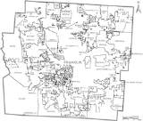
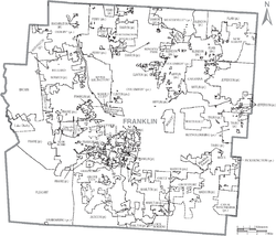 Franklin County is currently made up of 16 cities, 9 villages, and 17 townships.
U.S. state
A U.S. state is any one of the 50 federated states of the United States of America that share sovereignty with the federal government. Because of this shared sovereignty, an American is a citizen both of the federal entity and of his or her state of domicile. Four states use the official title of...
of Ohio
Ohio
Ohio is a Midwestern state in the United States. The 34th largest state by area in the U.S.,it is the 7th‑most populous with over 11.5 million residents, containing several major American cities and seven metropolitan areas with populations of 500,000 or more.The state's capital is Columbus...
, United States
United States
The United States of America is a federal constitutional republic comprising fifty states and a federal district...
. In 2010 the population was 1,163,414, making it the second largest county in Ohio (after Cuyahoga County
Cuyahoga County, Ohio
Cuyahoga County is a county located in the state of Ohio, United States. It is the most populous county in Ohio; as of the 2010 census, the population was 1,280,122. Its county seat is Cleveland. Cuyahoga County is part of Greater Cleveland, a metropolitan area, and Northeast Ohio, a...
) and the 34th largest county in population in the United States. Franklin County is also the largest in the eight-county Columbus, Ohio
Columbus, Ohio
Columbus is the capital of and the largest city in the U.S. state of Ohio. The broader metropolitan area encompasses several counties and is the third largest in Ohio behind those of Cleveland and Cincinnati. Columbus is the third largest city in the American Midwest, and the fifteenth largest city...
Metropolitan Statistical Area. Its county seat
County seat
A county seat is an administrative center, or seat of government, for a county or civil parish. The term is primarily used in the United States....
is Columbus
Columbus, Ohio
Columbus is the capital of and the largest city in the U.S. state of Ohio. The broader metropolitan area encompasses several counties and is the third largest in Ohio behind those of Cleveland and Cincinnati. Columbus is the third largest city in the American Midwest, and the fifteenth largest city...
, which is located in the middle of the county. Columbus is the largest city in Ohio and the 15th largest city in the United States, according to the U.S. Census Bureau's 2005 Population Estimates. Columbus makes up about 66.56% of the population of the county, the rest being provided by various suburb
Suburb
The word suburb mostly refers to a residential area, either existing as part of a city or as a separate residential community within commuting distance of a city . Some suburbs have a degree of administrative autonomy, and most have lower population density than inner city neighborhoods...
s and township
Township
The word township is used to refer to different kinds of settlements in different countries. Township is generally associated with an urban area. However there are many exceptions to this rule. In Australia, the United States, and Canada, they may be settlements too small to be considered urban...
s, and Franklin County itself makes up about 9.42% of the state population as of 2000.
Franklin County, particularly Columbus, has been a centerpiece for presidential and congressional politics, most notably the 2000 presidential election
United States presidential election, 2000
The United States presidential election of 2000 was a contest between Republican candidate George W. Bush, then-governor of Texas and son of former president George H. W. Bush , and Democratic candidate Al Gore, then-Vice President....
, the 2004 presidential election
United States presidential election, 2004
The United States presidential election of 2004 was the United States' 55th quadrennial presidential election. It was held on Tuesday, November 2, 2004. Republican Party candidate and incumbent President George W. Bush defeated Democratic Party candidate John Kerry, the then-junior U.S. Senator...
, and the 2006 midterm elections. Franklin County is home to the largest university
University
A university is an institution of higher education and research, which grants academic degrees in a variety of subjects. A university is an organisation that provides both undergraduate education and postgraduate education...
in the United States, The Ohio State University
Ohio State University
The Ohio State University, commonly referred to as Ohio State, is a public research university located in Columbus, Ohio. It was originally founded in 1870 as a land-grant university and is currently the third largest university campus in the United States...
, which as of fall 2011 has an enrollment of 56,867 students on its main Columbus campus .
The county was established on April 30, 1803, less than two months after Ohio became a state, and was named after Benjamin Franklin
Benjamin Franklin
Dr. Benjamin Franklin was one of the Founding Fathers of the United States. A noted polymath, Franklin was a leading author, printer, political theorist, politician, postmaster, scientist, musician, inventor, satirist, civic activist, statesman, and diplomat...
. Franklin County originally extended all the way north to Lake Erie
Lake Erie
Lake Erie is the fourth largest lake of the five Great Lakes in North America, and the tenth largest globally. It is the southernmost, shallowest, and smallest by volume of the Great Lakes and therefore also has the shortest average water residence time. It is bounded on the north by the...
before Ohio subdivided further into more counties.
Geography
According to the U.S. Census BureauUnited States Census Bureau
The United States Census Bureau is the government agency that is responsible for the United States Census. It also gathers other national demographic and economic data...
, Franklin County has a total area of 543 square miles (1,406.4 km²), of which 540 square miles (1,398.6 km²) is land and 3 square miles (7.8 km²) (0.63%) is water. The county is located in the Till Plains and the Appalachian Plateau
Appalachian Plateau
The Appalachian Plateau is the western part of the Appalachian mountains, stretching from New York and Alabama. The plateau is a second level United States physiographic region....
land regions.
The county is drained by the Olentangy River
Olentangy River
The Olentangy River is a tributary of the Scioto River in Ohio.It was originally called keenhongsheconsepung, a Delaware word literally translated as "stone for your knife stream", based on the shale found along its shores. Early settlers to the region translated this into "Whetstone River"...
and the Scioto River
Scioto River
The Scioto River is a river in central and southern Ohio more than 231 miles in length. It rises in Auglaize County in west central Ohio, flows through Columbus, Ohio, where it collects its largest tributary, the Olentangy River, and meets the Ohio River at Portsmouth...
. Major creeks in the county include Big Darby Creek
Big Darby Creek
The Big Darby Creek is a river located in northwestern central Ohio, and an important tributary to the Lower Scioto River. The river's major tributary is the Little Darby Creek....
, Walnut Creek, and Alum Creek
Alum Creek
Alum Creek is long creek that runs north to south in central Ohio. The creek originates in Morrow County and then flows through Delaware County and finally into Franklin County, where it ends at Big Walnut Creek, which drains into the Scioto River. In 1974, the Army Corps of Engineers completed...
. There are two large reservoirs in the county, Hoover Reservoir and Griggs Reservoir.
Adjacent counties
- Delaware CountyDelaware County, OhioDelaware County is a fast-growing suburban county in the state of Ohio, United States, within the Columbus, Ohio Metropolitan Statistical Area. According to the United States Census Bureau's 2004 population estimates, Delaware County's population of 142,503 made it the fastest growing county in...
(north) - Licking CountyLicking County, OhioLicking County is a county located in the state of Ohio, United States. As of the 2010 census, the population was 166,492. Its county seat is Newark and is named for the salt licks that were in the area....
(northeast) - Fairfield CountyFairfield County, OhioFairfield County is a county located in the state of Ohio, United States. As of 2010, the population was 146,156. Its county seat is Lancaster. Its name is a reference to the Fairfield area of the original Lancaster....
(southeast) - Pickaway CountyPickaway County, OhioAs of the census of 2000, there were 52,727 people, 17,599 households, and 13,287 families residing in the county. The population density was 105 people per square mile . There were 18,596 housing units at an average density of 37 per square mile...
(south) - Madison CountyMadison County, OhioAs of the census of 2000, there were 40,213 people, 13,672 households, and 10,035 families residing in the county. The population density was 86 people per square mile . There were 14,399 housing units at an average density of 31 per square mile...
(west) - Union CountyUnion County, OhioUnion County is a county located in the US state of Ohio. As of the 2010 census, the population was 52,300. Increasingly becoming more of a suburban county, the population was estimated at 47,234 in 2007 by the U.S. Census Bureau...
(northwest)
Demographics
As of the censusCensus
A census is the procedure of systematically acquiring and recording information about the members of a given population. It is a regularly occurring and official count of a particular population. The term is used mostly in connection with national population and housing censuses; other common...
of 2000, there were 1,068,978 people, 438,778 households, and 263,705 families residing in the county. The population density
Population density
Population density is a measurement of population per unit area or unit volume. It is frequently applied to living organisms, and particularly to humans...
was 1,980 people per square mile (765/km²). There were 471,016 housing units at an average density of 872 per square mile (337/km²). The racial makeup of the county was 75.48% White
Race (United States Census)
Race and ethnicity in the United States Census, as defined by the Federal Office of Management and Budget and the United States Census Bureau, are self-identification data items in which residents choose the race or races with which they most closely identify, and indicate whether or not they are...
, 17.89% Black
Race (United States Census)
Race and ethnicity in the United States Census, as defined by the Federal Office of Management and Budget and the United States Census Bureau, are self-identification data items in which residents choose the race or races with which they most closely identify, and indicate whether or not they are...
or African American
Race (United States Census)
Race and ethnicity in the United States Census, as defined by the Federal Office of Management and Budget and the United States Census Bureau, are self-identification data items in which residents choose the race or races with which they most closely identify, and indicate whether or not they are...
, 0.27% Native American
Race (United States Census)
Race and ethnicity in the United States Census, as defined by the Federal Office of Management and Budget and the United States Census Bureau, are self-identification data items in which residents choose the race or races with which they most closely identify, and indicate whether or not they are...
, 3.07% Asian
Race (United States Census)
Race and ethnicity in the United States Census, as defined by the Federal Office of Management and Budget and the United States Census Bureau, are self-identification data items in which residents choose the race or races with which they most closely identify, and indicate whether or not they are...
, 0.04% Pacific Islander
Race (United States Census)
Race and ethnicity in the United States Census, as defined by the Federal Office of Management and Budget and the United States Census Bureau, are self-identification data items in which residents choose the race or races with which they most closely identify, and indicate whether or not they are...
, 1.03% from other races
Race (United States Census)
Race and ethnicity in the United States Census, as defined by the Federal Office of Management and Budget and the United States Census Bureau, are self-identification data items in which residents choose the race or races with which they most closely identify, and indicate whether or not they are...
, and 2.23% from two or more races. 2.27% of the population were Hispanic
Race (United States Census)
Race and ethnicity in the United States Census, as defined by the Federal Office of Management and Budget and the United States Census Bureau, are self-identification data items in which residents choose the race or races with which they most closely identify, and indicate whether or not they are...
or Latino
Race (United States Census)
Race and ethnicity in the United States Census, as defined by the Federal Office of Management and Budget and the United States Census Bureau, are self-identification data items in which residents choose the race or races with which they most closely identify, and indicate whether or not they are...
of any race.
There were 438,778 households out of which 30.40% had children under the age of 18 living with them, 43.00% were married couples
Marriage
Marriage is a social union or legal contract between people that creates kinship. It is an institution in which interpersonal relationships, usually intimate and sexual, are acknowledged in a variety of ways, depending on the culture or subculture in which it is found...
living together, 13.00% had a female householder with no husband present, and 39.90% were non-families. 30.90% of all households were made up of individuals and 7.40% had someone living alone who was 65 years of age or older. The average household size was 2.39 and the average family size was 3.03.
In the county the population was spread out with 25.10% under the age of 18, 11.70% from 18 to 24, 33.30% from 25 to 44, 20.10% from 45 to 64, and 9.80% who were 65 years of age or older. The median age was 32 years. For every 100 females there were 94.50 males. For every 100 females age 18 and over, there were 91.50 males.
The median income for a household in the county was $42,734, and the median income for a family was $53,905. Males had a median income of $37,672 versus $29,856 for females. The per capita income
Per capita income
Per capita income or income per person is a measure of mean income within an economic aggregate, such as a country or city. It is calculated by taking a measure of all sources of income in the aggregate and dividing it by the total population...
for the county was $23,059. About 8.20% of families and 11.60% of the population were below the poverty line, including 14.20% of those under age 18 and 8.60% of those age 65 or over.
History
On March 30, 1803, the Ohio government authorized the creation of Franklin County. The county originally was part of Ross CountyRoss County, Ohio
As of the census of 2000, there were 73,345 people, 27,136 households, and 19,185 families residing in the county. The population density was 106 people per square mile . There were 29,461 housing units at an average density of 43 per square mile...
. Residents named the county in honor of Benjamin Franklin
Benjamin Franklin
Dr. Benjamin Franklin was one of the Founding Fathers of the United States. A noted polymath, Franklin was a leading author, printer, political theorist, politician, postmaster, scientist, musician, inventor, satirist, civic activist, statesman, and diplomat...
. In 1816, Franklin County’s Columbus became Ohio’s state capital. Surveyors laid out the city in 1812, and officials incorporated it in 1816. Columbus was not Ohio’s original capital, but the state legislature chose to move the state government there after its location for a short time at Chillicothe
Chillicothe, Ohio
Chillicothe is a city in and the county seat of Ross County, Ohio, United States.Chillicothe was the first and third capital of Ohio and is located in southern Ohio along the Scioto River. The name comes from the Shawnee name Chalahgawtha, meaning "principal town", as it was a major settlement of...
and at Zanesville
Zanesville, Ohio
Zanesville is a city in and the county seat of Muskingum County, Ohio, United States. The population was 25,586 at the 2000 census.Zanesville was named after Ebenezer Zane, who had constructed Zane's Trace, a pioneer road through present-day Ohio...
. Columbus was chosen as the site for the new capital because of its central location within the state and access by way of major transportation routes (primarily rivers) at that time. The legislature
Legislature
A legislature is a kind of deliberative assembly with the power to pass, amend, and repeal laws. The law created by a legislature is called legislation or statutory law. In addition to enacting laws, legislatures usually have exclusive authority to raise or lower taxes and adopt the budget and...
chose it as Ohio’s capital over a number of other competitors, including Franklinton, Dublin
Dublin, Ohio
Dublin is a city in Franklin, Delaware, and Union counties in the U.S. state of Ohio. The population was 41,751 at the 2010 census. Dublin is a suburb of Columbus, Ohio. Approximately 57,000 people live within the Dublin school district....
, Worthington
Worthington, Ohio
-Dissolution of the Company:By August 11, 1804 the plat maps were completed, payments or notes promising payments collected and deeds prepared for all sixteen thousand acres of the Scioto Company's purchase...
, and Delaware
Delaware, Ohio
The City of Delaware is a city in and the county seat of Delaware County in the United States state of Ohio. Delaware was founded in 1808 and was incorporated in 1816. It is located near the center of Ohio, is about north of Columbus, and is part of the Columbus, Ohio Metropolitan Area...
.
Prior to the state legislature’s decision in 1812, Columbus did not exist. The city was designed from the first as the state’s capital, preparing itself for its role in Ohio’s political, economic, and social life. In the years between first ground-breaking and the actual movement of the capital in 1816, Columbus and Franklin County grew significantly. By 1813, workers had built a penitentiary
Prison
A prison is a place in which people are physically confined and, usually, deprived of a range of personal freedoms. Imprisonment or incarceration is a legal penalty that may be imposed by the state for the commission of a crime...
, and by the following year, residents had established the first church, school
School
A school is an institution designed for the teaching of students under the direction of teachers. Most countries have systems of formal education, which is commonly compulsory. In these systems, students progress through a series of schools...
, and newspaper
Newspaper
A newspaper is a scheduled publication containing news of current events, informative articles, diverse features and advertising. It usually is printed on relatively inexpensive, low-grade paper such as newsprint. By 2007, there were 6580 daily newspapers in the world selling 395 million copies a...
in Columbus. Workers completed the Ohio Statehouse
Ohio Statehouse
The Ohio Statehouse, located in Columbus, Ohio, is the house of government for the state of Ohio. The Greek Revival building houses the Ohio General Assembly and the ceremonial offices of the Governor, Lieutenant Governor, Treasurer, and Auditor....
in 1814. Columbus and Franklin County grew quickly in population, with the city having 700 people by 1815. Columbus officially became the county seat in 1824. By 1834, the population of Columbus was 4,000 people, officially elevating it to "city" status.
Government
Communities
Cities
|
Grove City, Ohio As of the census of 2000, there were 27,075 people, 10,265 households, and 7,544 families residing in the city. The population density was 1,941.2 people per square mile . There were 10,712 housing units at an average density of 768.0 per square mile... Groveport, Ohio Groveport is a City in Franklin County, Ohio, United States. The population was 5,363 at the 2010 census.Groveport was the hometown of John Solomon Rarey, a 19th century horse whisperer, and developer of the Rarey technique for rehabilitating horses... Hilliard, Ohio Hilliard is a city in Franklin County, Ohio, United States. The population was 28,435 at the 2010 census.-Geography:Hilliard is located at . It is bordered on the east by Upper Arlington, on the north by Dublin, on the south by Galloway and Columbus, and to the west lies open farmland... New Albany, Ohio As of the census of 2000, there were 3,711 people, 1,263 households, and 1,030 families residing in the village. The population density was 415.7 people per square mile . There were 1,424 housing units at an average density of 159.5 per square mile... Pickerington, Ohio As of the census of 2000, there were 9,792 people, 3,468 households, and 2,687 families residing in the city. The population density was 1,317.4 people per square mile . There were 3,573 housing units at an average density of 480.7 per square mile... |
Reynoldsburg, Ohio Reynoldsburg is a city in Fairfield, Franklin, and Licking counties in the U.S. state of Ohio. It is a suburban community in the Columbus, Ohio metropolitan area... Upper Arlington, Ohio Upper Arlington is a suburban city in Franklin County, Ohio, United States, on the northwest side of the Columbus metropolitan area. The population was 33,686 at the 2000 census.-Geography:... Westerville, Ohio Westerville, once known as "The Dry Capital of the World", is a city in Franklin and Delaware counties in the U.S. state of Ohio. The population was 35,318 at the 2000 census.-Early history:... Whitehall, Ohio As of the census of 2000, there were 19,201 people, 8,343 households, and 4,930 families residing in the city. The population density was 3,681.9 people per square mile . There were 8,997 housing units at an average density of 1,725.2 per square mile... Worthington, Ohio -Dissolution of the Company:By August 11, 1804 the plat maps were completed, payments or notes promising payments collected and deeds prepared for all sixteen thousand acres of the Scioto Company's purchase... |
Villages
|
Obetz, Ohio Obetz is a village in Franklin County, Ohio, United States. The population was 3,977 at the 2000 census, and estimated to be 4,079 as of 2005. The community was formed in 1838 as a railroad junction, and incorporated in 1928.-Geography:... Riverlea, Ohio Riverlea is a village in Franklin County, Ohio, United States, surrounded by Worthington on its north, south, and east sides, and bordered on the west by the Olentangy River, across which is Columbus. Riverlea was incorporated in 1939, a small community that formed on former farmland... Urbancrest, Ohio Urbancrest is a village in Franklin County, Ohio, United States. The population was 868 at the 2000 census. Urbancrest is in the South-Western City Schools District.-Geography:Urbancrest is located at .... Valleyview, Ohio Valleyview is a village in Franklin County, Ohio, United States. The population was 601 at the 2000 census.-Geography:Valleyview is located at .... |
Townships
|
Jefferson Township, Franklin County, Ohio Jefferson Township is one of the seventeen townships of Franklin County, Ohio, United States. The 2000 census found 5,322 people in the township, 4,599 of whom lived in the unincorporated portions of the township.-Geography:... Madison Township, Franklin County, Ohio Madison Township is one of the seventeen townships of Franklin County, Ohio, United States. The 2000 census found 21,243 people in the township, 12,355 of whom lived in the unincorporated portions of the township.-Geography:... Mifflin Township, Franklin County, Ohio Mifflin Township is one of the seventeen townships of Franklin County, Ohio, United States. The 2000 census found 35,787 people in the township, 3,151 of whom lived in the unincorporated portions of the township.-Geography:... Norwich Township, Franklin County, Ohio Norwich Township is one of the seventeen townships of Franklin County, Ohio, United States. The 2000 census found 27,488 people in the township, 3,635 of whom lived in the unincorporated portions of the township.-Geography:... Perry Township, Franklin County, Ohio Perry Township is one of the seventeen townships of Franklin County, Ohio, United States. The 2000 census found 4,087 people in the township.-Geography:Most of Perry Township is now part of one of these four cities:... Plain Township, Franklin County, Ohio Plain Township is one of the seventeen townships of Franklin County, Ohio, United States. The 2000 census found 5,926 people in the township, 2,215 of whom lived in the unincorporated portions of the township.-Geography:... |
Pleasant Township, Franklin County, Ohio Pleasant Township is one of the seventeen townships of Franklin County, Ohio, United States. The 2000 census found 7,030 people in the township, 6,704 of whom lived in the unincorporated portions of the township.-Geography:... Prairie Township, Franklin County, Ohio Prairie Township is one of the seventeen townships of Franklin County, Ohio, United States. The 2000 census found 17,118 people in the township, 17,058 of whom lived in the unincorporated portions of the township, and 60 of whom lived in the now-defunct village of New Rome.-Geography:Located in... Sharon Township, Franklin County, Ohio Sharon Township is one of the seventeen townships of Franklin County, Ohio, United States. The 2000 census found 16,455 people in the township, 1,831 of whom lived in the unincorporated portions of the township.-Geography:... Truro Township, Franklin County, Ohio Truro Township is one of the seventeen townships of Franklin County, Ohio, United States. The 2000 census found 27,151 people in the township, 1,416 of whom lived in the unincorporated portions of the township.-Geography:... Washington Township, Franklin County, Ohio Washington Township is one of the seventeen townships of Franklin County, Ohio, United States. Although it is located only in Franklin County, it is connected with areas in Delaware and Union counties... |
Census-designated places
|
Lake Darby, Ohio Lake Darby is a census-designated place in Franklin County, Ohio, United States: located partly in Brown Township and partly in Prairie Township. It is more commonly known among locals as Darby Estates, which is also the name of the older housing development there, with the newer development called... Lincoln Village, Ohio Lincoln Village is a census-designated place in Prairie Township, Franklin County, Ohio, United States. It is centered near the intersection of U.S. 40 and I-270 on the west side of Columbus. As of the 2000 census, the population was 9,482.... |
Other communities
|
Flint, Ohio Flint is an unincorporated community in Sharon Township, Franklin County, Ohio, United States, located north of downtown Columbus near the intersection of Flint and Park Roads... Galloway, Ohio Galloway is an unincorporated community west of the city of Columbus in southern Prairie Township, Franklin County, Ohio, United States. The 43119 ZIP Code, however covers a significant portion of rural and suburban western Franklin County, as well as parts of western Columbus, and locals might... |
Georgesville, Ohio Georgesville is an unincorporated community in western Pleasant Township, Franklin County, Ohio, United States. It is located southwest of Columbus, the county seat of Franklin County and the capital and largest city of Ohio. Georgesville lies at the confluence of Little Darby Creek and Big Darby... New Rome, Ohio New Rome is an unincorporated community in eastern Prairie Township, Franklin County, Ohio, United States, located on the west side of the Columbus, Ohio metropolitan area. It was originally incorporated as a village in 1947, occupying little more than a three-block stretch of West Broad Street ,... |