
Wayne County, Ohio
Encyclopedia
Wayne County is a county located in the state
of Ohio
, United States
, and is named for General "Mad" Anthony Wayne
. As of the 2010 census, the population was 114,520. http://quickfacts.census.gov/qfd/states/39/39169.html Its county seat
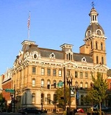
is Wooster
.
The Wooster Micropolitan Statistical Area includes all of Wayne County.
.jpg) According to the U.S. Census Bureau
According to the U.S. Census Bureau
, the county has a total area of 556 square miles (1,441 km²).555 square miles (1,438 km²) of it is land and 1 square miles (2 km²) of it (0.17%) is water.
of 2000, there were 111,564 people, 40,445 households, and 29,484 families residing in the county. The population density
was 201 people per square mile (78/km²). There were 42,324 housing units at an average density of 76 per square mile (29/km²). The racial makeup of the county was 96.52% White
, 1.57% Black
or African American
, 0.16% Native American
, 0.66% Asian
, 0.01% Pacific Islander
, 0.24% from other races
, and 0.84% from two or more races. 0.75% of the population were Hispanic
or Latino
of any race. 31.7% were of German
, 13.9% American
, 9.6% Irish
, 9.0% English
and 5.5% Swiss
ancestry according to Census 2000. 91.5% spoke English
, 3.2% German
, 1.6% Dutch
, 1.5% Pennsylvania Dutch
and 1.2% Spanish
as their first language.
There were 40,445 households out of which 35.00% had children under the age of 18 living with them, 60.80% were married couples
living together, 8.70% had a female householder with no husband present, and 27.10% were non-families. 22.70% of all households were made up of individuals and 8.70% had someone living alone who was 65 years of age or older. The average household size was 2.68 and the average family size was 3.17.
In the county, the population was spread out with 27.40% under the age of 18, 9.80% from 18 to 24, 27.80% from 25 to 44, 22.70% from 45 to 64, and 12.20% who were 65 years of age or older. The median age was 35 years. For every 100 females there were 97.50 males. For every 100 females age 18 and over, there were 94.50 males.
The median income for a household in the county was $41,538, and the median income for a family was $48,294. Males had a median income of $33,976 versus $23,203 for females. The per capita income
for the county was $18,330. About 5.40% of families and 8.00% of the population were below the poverty line, including 10.60% of those under age 18 and 6.90% of those age 65 or over.
and branches in Creston
, Dalton
, Doylestown
, Rittman
, Shreve
, and West Salem
. It also offers bookmobile service and outreach program, and patron can use the extended services of CLEVNET, a group of libraries located in northeast Ohio.
In 2005, the library loaned more than 1.2 million items to its 54,000 cardholders. Total holding are over 340,000 volumes with over 900 periodical subscriptions.
U.S. state
A U.S. state is any one of the 50 federated states of the United States of America that share sovereignty with the federal government. Because of this shared sovereignty, an American is a citizen both of the federal entity and of his or her state of domicile. Four states use the official title of...
of Ohio
Ohio
Ohio is a Midwestern state in the United States. The 34th largest state by area in the U.S.,it is the 7th‑most populous with over 11.5 million residents, containing several major American cities and seven metropolitan areas with populations of 500,000 or more.The state's capital is Columbus...
, United States
United States
The United States of America is a federal constitutional republic comprising fifty states and a federal district...
, and is named for General "Mad" Anthony Wayne
Anthony Wayne
Anthony Wayne was a United States Army general and statesman. Wayne adopted a military career at the outset of the American Revolutionary War, where his military exploits and fiery personality quickly earned him a promotion to the rank of brigadier general and the sobriquet of Mad Anthony.-Early...
. As of the 2010 census, the population was 114,520. http://quickfacts.census.gov/qfd/states/39/39169.html Its county seat
County seat
A county seat is an administrative center, or seat of government, for a county or civil parish. The term is primarily used in the United States....
is Wooster
Wooster, Ohio
Wooster is a city in the U.S. state of Ohio and the county seat of Wayne County. The municipality is located in northeastern Ohio approximately SSW of Cleveland and SW of Akron. Wooster is noted as the location of The College of Wooster...
.
The Wooster Micropolitan Statistical Area includes all of Wayne County.
Geography
United States Census Bureau
The United States Census Bureau is the government agency that is responsible for the United States Census. It also gathers other national demographic and economic data...
, the county has a total area of 556 square miles (1,441 km²).555 square miles (1,438 km²) of it is land and 1 square miles (2 km²) of it (0.17%) is water.
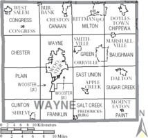
Adjacent counties
- Medina County (north)
- Summit CountySummit County, OhioSummit County is an urban county located in the state of Ohio, United States. As of the 2000 census, the population was 542,899. In the 2010 Census the population was 541,781. Its county seat is Akron...
(northeast) - Stark CountyStark County, OhioStark County is a county located in the U.S. state of Ohio. As of the 2010 census, the population was 375,586. It is included in the Canton-Massillon, Ohio Metropolitan Statistical Area....
(east) - Holmes CountyHolmes County, OhioAs of the census of 2000, there were 38,943 people, 11,337 households, and 9,194 families residing in the county. The population density was 92 people per square mile . There were 12,280 housing units at an average density of 29 per square mile...
(south) - Ashland CountyAshland County, OhioAshland County is a county located in the state of Ohio, United States, and was formed in 1846 from parts of Huron, Lorain, Richland and Wayne Counties. As of the 2010 census, the population was 53,139. Its county seat is Ashland...
(west)
Demographics
As of the censusCensus
A census is the procedure of systematically acquiring and recording information about the members of a given population. It is a regularly occurring and official count of a particular population. The term is used mostly in connection with national population and housing censuses; other common...
of 2000, there were 111,564 people, 40,445 households, and 29,484 families residing in the county. The population density
Population density
Population density is a measurement of population per unit area or unit volume. It is frequently applied to living organisms, and particularly to humans...
was 201 people per square mile (78/km²). There were 42,324 housing units at an average density of 76 per square mile (29/km²). The racial makeup of the county was 96.52% White
Race (United States Census)
Race and ethnicity in the United States Census, as defined by the Federal Office of Management and Budget and the United States Census Bureau, are self-identification data items in which residents choose the race or races with which they most closely identify, and indicate whether or not they are...
, 1.57% Black
Race (United States Census)
Race and ethnicity in the United States Census, as defined by the Federal Office of Management and Budget and the United States Census Bureau, are self-identification data items in which residents choose the race or races with which they most closely identify, and indicate whether or not they are...
or African American
Race (United States Census)
Race and ethnicity in the United States Census, as defined by the Federal Office of Management and Budget and the United States Census Bureau, are self-identification data items in which residents choose the race or races with which they most closely identify, and indicate whether or not they are...
, 0.16% Native American
Race (United States Census)
Race and ethnicity in the United States Census, as defined by the Federal Office of Management and Budget and the United States Census Bureau, are self-identification data items in which residents choose the race or races with which they most closely identify, and indicate whether or not they are...
, 0.66% Asian
Race (United States Census)
Race and ethnicity in the United States Census, as defined by the Federal Office of Management and Budget and the United States Census Bureau, are self-identification data items in which residents choose the race or races with which they most closely identify, and indicate whether or not they are...
, 0.01% Pacific Islander
Race (United States Census)
Race and ethnicity in the United States Census, as defined by the Federal Office of Management and Budget and the United States Census Bureau, are self-identification data items in which residents choose the race or races with which they most closely identify, and indicate whether or not they are...
, 0.24% from other races
Race (United States Census)
Race and ethnicity in the United States Census, as defined by the Federal Office of Management and Budget and the United States Census Bureau, are self-identification data items in which residents choose the race or races with which they most closely identify, and indicate whether or not they are...
, and 0.84% from two or more races. 0.75% of the population were Hispanic
Race (United States Census)
Race and ethnicity in the United States Census, as defined by the Federal Office of Management and Budget and the United States Census Bureau, are self-identification data items in which residents choose the race or races with which they most closely identify, and indicate whether or not they are...
or Latino
Race (United States Census)
Race and ethnicity in the United States Census, as defined by the Federal Office of Management and Budget and the United States Census Bureau, are self-identification data items in which residents choose the race or races with which they most closely identify, and indicate whether or not they are...
of any race. 31.7% were of German
Germans
The Germans are a Germanic ethnic group native to Central Europe. The English term Germans has referred to the German-speaking population of the Holy Roman Empire since the Late Middle Ages....
, 13.9% American
United States
The United States of America is a federal constitutional republic comprising fifty states and a federal district...
, 9.6% Irish
Irish people
The Irish people are an ethnic group who originate in Ireland, an island in northwestern Europe. Ireland has been populated for around 9,000 years , with the Irish people's earliest ancestors recorded having legends of being descended from groups such as the Nemedians, Fomorians, Fir Bolg, Tuatha...
, 9.0% English
English people
The English are a nation and ethnic group native to England, who speak English. The English identity is of early mediaeval origin, when they were known in Old English as the Anglecynn. England is now a country of the United Kingdom, and the majority of English people in England are British Citizens...
and 5.5% Swiss
Swiss (people)
The Swiss are citizens or natives of Switzerland. The demonym derives from the toponym of Schwyz and has been in widespread use to refer to the Old Swiss Confederacy since the 16th century....
ancestry according to Census 2000. 91.5% spoke English
English language
English is a West Germanic language that arose in the Anglo-Saxon kingdoms of England and spread into what was to become south-east Scotland under the influence of the Anglian medieval kingdom of Northumbria...
, 3.2% German
German language
German is a West Germanic language, related to and classified alongside English and Dutch. With an estimated 90 – 98 million native speakers, German is one of the world's major languages and is the most widely-spoken first language in the European Union....
, 1.6% Dutch
Dutch language
Dutch is a West Germanic language and the native language of the majority of the population of the Netherlands, Belgium, and Suriname, the three member states of the Dutch Language Union. Most speakers live in the European Union, where it is a first language for about 23 million and a second...
, 1.5% Pennsylvania Dutch
Pennsylvania German language
The Pennsylvania German language is a variety of West Central German possibly spoken by more than 250,000 people in North America...
and 1.2% Spanish
Spanish language
Spanish , also known as Castilian , is a Romance language in the Ibero-Romance group that evolved from several languages and dialects in central-northern Iberia around the 9th century and gradually spread with the expansion of the Kingdom of Castile into central and southern Iberia during the...
as their first language.
There were 40,445 households out of which 35.00% had children under the age of 18 living with them, 60.80% were married couples
Marriage
Marriage is a social union or legal contract between people that creates kinship. It is an institution in which interpersonal relationships, usually intimate and sexual, are acknowledged in a variety of ways, depending on the culture or subculture in which it is found...
living together, 8.70% had a female householder with no husband present, and 27.10% were non-families. 22.70% of all households were made up of individuals and 8.70% had someone living alone who was 65 years of age or older. The average household size was 2.68 and the average family size was 3.17.
In the county, the population was spread out with 27.40% under the age of 18, 9.80% from 18 to 24, 27.80% from 25 to 44, 22.70% from 45 to 64, and 12.20% who were 65 years of age or older. The median age was 35 years. For every 100 females there were 97.50 males. For every 100 females age 18 and over, there were 94.50 males.
The median income for a household in the county was $41,538, and the median income for a family was $48,294. Males had a median income of $33,976 versus $23,203 for females. The per capita income
Per capita income
Per capita income or income per person is a measure of mean income within an economic aggregate, such as a country or city. It is calculated by taking a measure of all sources of income in the aggregate and dividing it by the total population...
for the county was $18,330. About 5.40% of families and 8.00% of the population were below the poverty line, including 10.60% of those under age 18 and 6.90% of those age 65 or over.
Government
The Wayne County Public Library serves the communities of Wayne County, Ohio from its administrative offices in Wooster, OhioWooster, Ohio
Wooster is a city in the U.S. state of Ohio and the county seat of Wayne County. The municipality is located in northeastern Ohio approximately SSW of Cleveland and SW of Akron. Wooster is noted as the location of The College of Wooster...
and branches in Creston
Creston, Ohio
Creston is a village in Medina and Wayne counties in the U.S. state of Ohio. The population was 2,161 at the 2000 census. Creston is served by a branch of the Wayne County Public Library.-Geography:Creston is located at ....
, Dalton
Dalton, Ohio
Dalton is a village in Wayne County, Ohio, United States. The population was 1,605 at the 2000 census. Dalton is served by a branch of the Wayne County Public Library.-Geography:Dalton is located at ....
, Doylestown
Doylestown, Ohio
Doylestown is a village located atop the highest point in Wayne County, Ohio, United States. The population was 2,799 at the 2000 census. Doylestown is served by a branch of the Wayne County Public Library.-History:...
, Rittman
Rittman, Ohio
Rittman is a city in Medina and Wayne Counties in the U.S. state of Ohio. The city is in Wayne County, although a small portion of the city is located in Medina County. The population was 6,314 at the 2000 census...
, Shreve
Shreve, Ohio
Shreve is a village in Wayne County, Ohio, United States. The population was 1,582 at the 2000 census. Shreve is served by a branch of the Wayne County Public Library.-Geography:Shreve is located at ....
, and West Salem
West Salem, Ohio
West Salem is a village in Wayne County, Ohio, United States. The population was 1,501 at the 2000 census. West Salem is served by a branch of the Wayne County Public Library...
. It also offers bookmobile service and outreach program, and patron can use the extended services of CLEVNET, a group of libraries located in northeast Ohio.
In 2005, the library loaned more than 1.2 million items to its 54,000 cardholders. Total holding are over 340,000 volumes with over 900 periodical subscriptions.
Communities
Cities
|
Rittman, Ohio Rittman is a city in Medina and Wayne Counties in the U.S. state of Ohio. The city is in Wayne County, although a small portion of the city is located in Medina County. The population was 6,314 at the 2000 census... Wooster, Ohio Wooster is a city in the U.S. state of Ohio and the county seat of Wayne County. The municipality is located in northeastern Ohio approximately SSW of Cleveland and SW of Akron. Wooster is noted as the location of The College of Wooster... |
Villages
|
Creston, Ohio Creston is a village in Medina and Wayne counties in the U.S. state of Ohio. The population was 2,161 at the 2000 census. Creston is served by a branch of the Wayne County Public Library.-Geography:Creston is located at .... Dalton, Ohio Dalton is a village in Wayne County, Ohio, United States. The population was 1,605 at the 2000 census. Dalton is served by a branch of the Wayne County Public Library.-Geography:Dalton is located at .... Doylestown, Ohio Doylestown is a village located atop the highest point in Wayne County, Ohio, United States. The population was 2,799 at the 2000 census. Doylestown is served by a branch of the Wayne County Public Library.-History:... |
Fredericksburg, Ohio Fredericksburg is a village in Salt Creek Township, Wayne County, Ohio, United States. The population was 487 at the 2000 census.Fredericksburg was founded in 1824 by Jacob Frederick, and incorporated as a village in 1867.-Geography:... Marshallville, Ohio Marshallville is a village in Wayne County, Ohio, United States. The population was 826 at the 2000 census.-Geography:Marshallville is located at .... Mount Eaton, Ohio Mount Eaton is a village in Wayne County, Ohio, United States. The population was 246 at the 2000 census.-History:Located near Mount Eaton is the historic James Akey Farm, also known as the "Stark Wilderness Center Pioneer Farm"; it is listed on the National Register of Historic... |
Shreve, Ohio Shreve is a village in Wayne County, Ohio, United States. The population was 1,582 at the 2000 census. Shreve is served by a branch of the Wayne County Public Library.-Geography:Shreve is located at .... Smithville, Ohio Smithville is a village in Wayne County, Ohio, United States. The population was 1,333 at the 2000 census.Smithville is home to the historic "Smithville Inn" and "The Barn" restaurants, as well as the... West Salem, Ohio West Salem is a village in Wayne County, Ohio, United States. The population was 1,501 at the 2000 census. West Salem is served by a branch of the Wayne County Public Library... |
Townships
|
Clinton Township, Wayne County, Ohio Clinton Township is one of the sixteen townships of Wayne County, Ohio, United States. The 2000 census found 3,196 people in the township, 1,614 of whom lived in the unincorporated portions of the township.-Geography:... Congress Township, Wayne County, Ohio Congress Township is one of the sixteen townships of Wayne County, Ohio, United States. The 2000 census found 4,435 people in the township, 2,681 of whom lived in the unincorporated portions of the township.-Geography:... East Union Township, Wayne County, Ohio East Union Township is one of the sixteen townships of Wayne County, Ohio, United States. The 2000 census found 6,527 people in the township, 5,528 of whom lived in the unincorporated portions of the township.-Geography:... Franklin Township, Wayne County, Ohio Franklin Township is one of the sixteen townships of Wayne County, Ohio, United States. The 2000 census found 3,485 people in the township.-Geography:Located in the southern part of the county, it borders the following townships:*Wooster Township - north... |
Green Township, Wayne County, Ohio Green Township is one of the sixteen townships of Wayne County, Ohio, United States. The 2000 census found 12,194 people in the township, 7,078 of whom lived in the unincorporated portions of the township.-Geography:... Milton Township, Wayne County, Ohio Milton Township is one of the sixteen townships of Wayne County, Ohio, United States. The 2000 census found 9,254 people in the township, 3,053 of whom lived in the unincorporated portions of the township.-Geography:... Paint Township, Wayne County, Ohio Paint Township is one of the sixteen townships of Wayne County, Ohio, United States. The 2000 census found 2,823 people in the township, 2,577 of whom lived in the unincorporated portions of the township.-Geography:... Plain Township, Wayne County, Ohio Plain Township is one of the sixteen townships of Wayne County, Ohio, United States. The 2000 census found 2,894 people in the township.-Geography:Located in the western part of the county, it borders the following townships:*Chester Township - north... |
Salt Creek Township, Wayne County, Ohio Salt Creek Township is one of the sixteen townships of Wayne County, Ohio, United States. The 2000 census found 3,783 people in the township, 3,296 of whom lived in the unincorporated portions of the township.-Geography:... Sugar Creek Township, Wayne County, Ohio Sugar Creek Township is one of the sixteen townships of Wayne County, Ohio, United States. The 2000 census found 6,502 people in the township, 4,897 of whom lived in the unincorporated portions of the township.-Geography:... Wayne Township, Wayne County, Ohio Wayne Township is one of the sixteen townships of Wayne County, Ohio, United States. The 2000 census found 4,034 people in the township.-Geography:Located in the central part of the county, it borders the following townships:*Canaan Township - north... Wooster Township, Wayne County, Ohio Wooster Township is one of the sixteen townships of Wayne County, Ohio, United States. The 2000 census found 5,250 people in the township.-Geography:Located in the central part of the county, it borders the following townships:*Wayne Township - north... |
Unincorporated communities
- FunkFunk, OhioFunk is an unincorporated community in southwestern Plain Township, Wayne County, Ohio, United States. Because it is not tracked by the U.S. Census, a Census population estimate is not available....
- KidronKidron, OhioKidron is an unincorporated community in southwestern Sugar Creek Township, Wayne County, Ohio, United States.It is home to an outdoor flea market held Thursdays and Saturdays, weather permitting, and, since 1929, a retail store called Kidron Town and Country, which includes a grocery store,...
- SterlingSterling, OhioSterling is an unincorporated community in northwestern Milton Township, Wayne County, Ohio, United States. Although it is unincorporated, it has a post office, with the ZIP code of 44276.-References:...
See also
- Death on a Factory FarmDeath on a Factory FarmDeath on a Factory Farm is a 2009 television documentary film concerning the animal rights abuses at the Wiles hog farm, and the subsequent investigation and trial.-Synopsis:...
- National Register of Historic Places listings in Wayne County, OhioNational Register of Historic Places listings in Wayne County, OhioThis is a list of the National Register of Historic Places listings in Wayne County, Ohio.This is intended to be a complete list of the properties and districts on the National Register of Historic Places in Wayne County, Ohio, United States...