
Allen County, Ohio
Encyclopedia
Allen County is a county located in the U.S. state
of Ohio
. Its population was 106,331 as of the 2010 census
. http://quickfacts.census.gov/qfd/states/39/39003.html It is included in the Lima, Ohio
Metropolitan Statistical Area
as well as the Lima–Van Wert
–Wapakoneta
Combined Statistical Area
.
It is named for Colonel John Allen
, who was killed leading his men at the Battle of Frenchtown
, during the War of 1812
. Although it has also been claimed the county was named for Revolutionary War
soldier Ethan Allen
, the weight of the evidence in favor of John Allen led the General Assembly
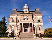
to declare that the county was named for him. The county seat
is Lima
.
Under the terms of the Treaty of Greenville
signed in 1795, northwestern Ohio was reserved for Native Americans. Thus the area now comprising Allen County was off-limits to European settlement until the Treaty of Maumee Rapids in 1817. Under the terms of this treaty, the Shawnee tribe
was assigned reservations at Wapakonetta
and at their "Hog Creek" settlement along the Ottawa River
which comprised most of what is the present-day Shawnee Township
. The latter treaty opened the way for the Ohio Legislature
on March 1, 1820 to create fourteen counties, including Allen, which was defined as Ranges 5 through 8 east and Towns 3 through 6 south.
The first permanent settlement within the present day bounds of Allen County took place in 1824, when Christopher S. Wood and his family settled in section 7 of Bath Township
. The organization of Bath Township predates that of Allen County itself, with its first township meeting held on March 2, 1829. On Feb. 12, 1829, an act of the legislature set aside land for a "county town". Wood was appointed commissioner to determine the location of this "seat of justice" for Allen County. This was done on March 3, 1831, with Wood appointed as Town Director. He laid out plots of land to be sold in section 31 of Bath Township, and the plat
was filed April 20, 1831, creating what was the beginning of the city of Lima
.
The organization of Allen County itself dates from the first meeting of the county commissioners, held on June 6, 1831. Present at this meeting were Commissioners James Daniels, John G. Wood, and Samuel Stewart. Also present was William G. Wood, county auditor; Adam White, county treasurer; and Henry Lippincott, sheriff.
The first court of justice was held in August 1831, and it is believed that the assembly of men, in informal session, selected the name for the seat of justice by drawing names from a hat. The meeting was held at the cabin of James Daniels, which was located on the bank of the Ottawa River
near the current location of Market Street. Patrick G. Goode of Montgomery County
, special prosecuting attorney at that session, is given credit for having offered up the name of "Lima
" (capital of Peru
and source of the quinine
used to treat the malaria
prevalent in the area of the Great Black Swamp
). At the County Commission session on June 6, 1831, the formation of a second township, Jackson
, was approved.
In 1832 the Shawnees, including those living in the Hog Creek reservation (present day Shawnee Township), were removed to eastern Kansas. They received payment of $30 000 in fifteen annual installments for their lands which had an estimated value of over $200 000 at that time. They arrived at their new home with few provisions and immediately suffered an epidemic of cholera.
Lima was established as a village in 1841, and the town of Lima was organized March 29, 1842. Henry DeVilliers Williams was elected the first mayor and Amos Clutter was elected the first town marshall.
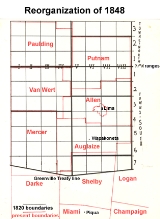
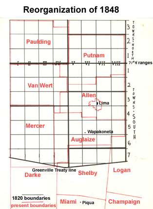
In 1848, the boundaries of Allen County changed with a reorganization that created Auglaize County, Ohio
from the southern half of the original county. Town 2S, Range 7E (Monroe Twp.); Town 2S, Range 8E (Richland Twp.); the southern half of Town 2S, Range 5E, and the southern half of Town 2S, Range 6E (Sugar Creek Twp.) were transferred from Putnam County
to Allen County. Parts of Van Wert and Mercer
Counties were also transferred to Allen to form Spencer Township
and part of Marion Township
. In May, 1853, Allen and Putnam Counties agreed on a cash settlement for Putnam's loss.
There were several practical implications of these changes to the boundaries of Allen County. Lima
, the county seat, became located near the center of the county, rather than in the northern quarter. The western part of the county gained a significant stretch of the Miami and Erie Canal
, which was completed in 1845. The reorganization also brought the towns of Spencerville, laid out in 1844 and located on the canal, and Bluffton within the bounds of the county.
In 1885, oil was discovered in Lima. This began a boom in Allen County which lasted until after 1910.
 According to the U.S. Census Bureau
, the county has a total area of 407 square miles (1,054.1 km²). 404 square miles (1,046.4 km²) is land and 2 square miles (5.2 km²) (0.60%) is water.
of 2000, there were 108,473 people, 40,646 households, and 28,208 families residing in the county. The population density
was 268 people per square mile (104/km²). There were 44,245 housing units at an average density of 109 per square mile (42/km²). The racial makeup of the county was 84.95% White
, 12.19% Black
or African American
, 0.21% Native American
, 0.55% Asian
, 0.01% Pacific Islander
, 0.63% from other races
, and 1.45% from two or more races. 1.42% of the population were Hispanic
or Latino
of any race. 33.8% were of German
, 14.2% American
, 8.8% Irish
and 6.6% English
ancestry according to Census 2000.
There were 40,646 households out of which 32.90% had children under the age of 18 living with them, 53.00% were married couples
living together, 12.40% had a female householder with no husband present, and 30.60% were non-families. 26.30% of all households were made up of individuals and 11.20% had someone living alone who was 65 years of age or older. The average household size was 2.52 and the average family size was 3.05.
In the county the population was spread out with 25.90% under the age of 18, 9.90% from 18 to 24, 27.60% from 25 to 44, 22.40% from 45 to 64, and 14.20% who were 65 years of age or older. The median age was 36 years. For every 100 females there were 100.00 males. For every 100 females age 18 and over, there were 98.00 males.
The median income for a household in the county was $37,048, and the median income for a family was $44,723. Males had a median income of $35,546 versus $23,537 for females. The per capita income
for the county was $17,511. About 9.60% of families and 12.10% of the population were below the poverty line, including 17.00% of those under age 18 and 9.60% of those age 65 or over.
since 1851, the Fair is amongst the foremost agricultural showcasing events in Western Ohio. In 2005, there were over 220,000 visitors and almost 3,000 exhibitors, making it the largest in the state.
The fair has also been notable for attracting many nationally known performers during the 1980s and 1990s, and combined with significant renovations to the county show grounds, these two factors have contributed to a marked increase in attendance and notoriety over the past two decades.
U.S. state
A U.S. state is any one of the 50 federated states of the United States of America that share sovereignty with the federal government. Because of this shared sovereignty, an American is a citizen both of the federal entity and of his or her state of domicile. Four states use the official title of...
of Ohio
Ohio
Ohio is a Midwestern state in the United States. The 34th largest state by area in the U.S.,it is the 7th‑most populous with over 11.5 million residents, containing several major American cities and seven metropolitan areas with populations of 500,000 or more.The state's capital is Columbus...
. Its population was 106,331 as of the 2010 census
United States Census, 2010
The Twenty-third United States Census, known as Census 2010 or the 2010 Census, is the current national census of the United States. National Census Day was April 1, 2010 and is the reference date used in enumerating individuals...
. http://quickfacts.census.gov/qfd/states/39/39003.html It is included in the Lima, Ohio
Lima, Ohio
Lima is a city in and the county seat of Allen County, Ohio, United States. The municipality is located in northwestern Ohio along Interstate 75 approximately north of Dayton and south-southwest of Toledo....
Metropolitan Statistical Area
Lima, Ohio metropolitan area
The Lima Metropolitan Statistical Area, as defined by the United States Census Bureau, is an area consisting of one county – Allen – in Northwest Ohio, anchored by the city of Lima. As of the 2000 census, the MSA had a population of 108,473 .-History:The Lima metropolitan area was first...
as well as the Lima–Van Wert
Van Wert, Ohio
As of the census of 2000, there were 10,690 people, 4,556 households, and 2,947 families residing in the city. The population density was 1,803.8 people per square mile . There were 4,927 housing units at an average density of 831.4 per square mile...
–Wapakoneta
Wapakoneta, Ohio
Wapakoneta is a city in and the county seat of Auglaize County, Ohio, United States with a population of 9,474 as of the 2000 U.S. census. It is the principal city of and is included in the Wapakoneta, Ohio Micropolitan S A, which is included in the Lima-Van Wert-Wapakoneta, Ohio CSA...
Combined Statistical Area
Lima-Van Wert-Wapakoneta, OH Combined Statistical Area
The Lima–Van Wert–Wapakoneta Combined Statistical Area is made up of three counties in Northwest Ohio. The Lima Metropolitan Statistical Area and two Micropolitan Statistical Areas – Van Wert and Wapakoneta, are components of the CSA...
.
It is named for Colonel John Allen
John Allen (soldier)
John Allen was a United States politician and army officer who was killed in the War of 1812.Allen was born in Rockbridge County, Virginia, and moved with his father to Kentucky in 1779. He went to school in Bardstown, Kentucky and studied law in Staunton, Virginia. He then returned to Kentucky...
, who was killed leading his men at the Battle of Frenchtown
Battle of Frenchtown
The Battle of Frenchtown, also known as the Battle of the River Raisin or the River Raisin Massacre, was a series of conflicts that took place from January 18–23, 1813 during the War of 1812...
, during the War of 1812
War of 1812
The War of 1812 was a military conflict fought between the forces of the United States of America and those of the British Empire. The Americans declared war in 1812 for several reasons, including trade restrictions because of Britain's ongoing war with France, impressment of American merchant...
. Although it has also been claimed the county was named for Revolutionary War
American Revolutionary War
The American Revolutionary War , the American War of Independence, or simply the Revolutionary War, began as a war between the Kingdom of Great Britain and thirteen British colonies in North America, and ended in a global war between several European great powers.The war was the result of the...
soldier Ethan Allen
Ethan Allen
Ethan Allen was a farmer, businessman, land speculator, philosopher, writer, and American Revolutionary War patriot, hero, and politician. He is best known as one of the founders of the U.S...
, the weight of the evidence in favor of John Allen led the General Assembly
Ohio General Assembly
The Ohio General Assembly is the state legislature of the U.S. state of Ohio. It consists of the 99-member Ohio House of Representatives and the 33-member Ohio Senate...
to declare that the county was named for him. The county seat
County seat
A county seat is an administrative center, or seat of government, for a county or civil parish. The term is primarily used in the United States....
is Lima
Lima, Ohio
Lima is a city in and the county seat of Allen County, Ohio, United States. The municipality is located in northwestern Ohio along Interstate 75 approximately north of Dayton and south-southwest of Toledo....
.
History
Under the terms of the Treaty of Greenville
Treaty of Greenville
The Treaty of Greenville was signed at Fort Greenville , on August 3, 1795, between a coalition of Native Americans & Frontiers men, known as the Western Confederacy, and the United States following the Native American loss at the Battle of Fallen Timbers. It put an end to the Northwest Indian War...
signed in 1795, northwestern Ohio was reserved for Native Americans. Thus the area now comprising Allen County was off-limits to European settlement until the Treaty of Maumee Rapids in 1817. Under the terms of this treaty, the Shawnee tribe
Shawnee
The Shawnee, Shaawanwaki, Shaawanooki and Shaawanowi lenaweeki, are an Algonquian-speaking people native to North America. Historically they inhabited the areas of Ohio, Virginia, West Virginia, Western Maryland, Kentucky, Indiana, and Pennsylvania...
was assigned reservations at Wapakonetta
Wapakoneta, Ohio
Wapakoneta is a city in and the county seat of Auglaize County, Ohio, United States with a population of 9,474 as of the 2000 U.S. census. It is the principal city of and is included in the Wapakoneta, Ohio Micropolitan S A, which is included in the Lima-Van Wert-Wapakoneta, Ohio CSA...
and at their "Hog Creek" settlement along the Ottawa River
Ottawa River (Auglaize River)
The Ottawa River is a tributary of the Auglaize River, approximately long, in northwestern Ohio in the United States. The river is named for the Ottawa tribe of Native Americans who inhabited the area in the 18th century...
which comprised most of what is the present-day Shawnee Township
Shawnee Township, Allen County, Ohio
Shawnee Township is one of the twelve townships of Allen County, Ohio, United States. The 2000 census found 12,220 people in the township, 8,365 of whom lived in the unincorporated portions of the township.-Geography:...
. The latter treaty opened the way for the Ohio Legislature
Ohio General Assembly
The Ohio General Assembly is the state legislature of the U.S. state of Ohio. It consists of the 99-member Ohio House of Representatives and the 33-member Ohio Senate...
on March 1, 1820 to create fourteen counties, including Allen, which was defined as Ranges 5 through 8 east and Towns 3 through 6 south.
The first permanent settlement within the present day bounds of Allen County took place in 1824, when Christopher S. Wood and his family settled in section 7 of Bath Township
Bath Township, Allen County, Ohio
The township is governed by a three-member board of trustees, who are elected in November of odd-numbered years to a four-year term beginning on the following January 1. Two are elected in the year after the presidential election and one is elected in the year before it...
. The organization of Bath Township predates that of Allen County itself, with its first township meeting held on March 2, 1829. On Feb. 12, 1829, an act of the legislature set aside land for a "county town". Wood was appointed commissioner to determine the location of this "seat of justice" for Allen County. This was done on March 3, 1831, with Wood appointed as Town Director. He laid out plots of land to be sold in section 31 of Bath Township, and the plat
Plat
A plat in the U.S. is a map, drawn to scale, showing the divisions of a piece of land. Other English-speaking countries generally call such documents a cadastral map or plan....
was filed April 20, 1831, creating what was the beginning of the city of Lima
Lima, Ohio
Lima is a city in and the county seat of Allen County, Ohio, United States. The municipality is located in northwestern Ohio along Interstate 75 approximately north of Dayton and south-southwest of Toledo....
.
The organization of Allen County itself dates from the first meeting of the county commissioners, held on June 6, 1831. Present at this meeting were Commissioners James Daniels, John G. Wood, and Samuel Stewart. Also present was William G. Wood, county auditor; Adam White, county treasurer; and Henry Lippincott, sheriff.
The first court of justice was held in August 1831, and it is believed that the assembly of men, in informal session, selected the name for the seat of justice by drawing names from a hat. The meeting was held at the cabin of James Daniels, which was located on the bank of the Ottawa River
Ottawa River (Auglaize River)
The Ottawa River is a tributary of the Auglaize River, approximately long, in northwestern Ohio in the United States. The river is named for the Ottawa tribe of Native Americans who inhabited the area in the 18th century...
near the current location of Market Street. Patrick G. Goode of Montgomery County
Montgomery County, Ohio
Montgomery County is a county located in the state of Ohio, United States. The population was 535,153 in the 2010 Census. It was named in honor of Richard Montgomery, an American Revolutionary War general killed in 1775 while attempting to capture Quebec City, Canada. The county seat is Dayton...
, special prosecuting attorney at that session, is given credit for having offered up the name of "Lima
Lima
Lima is the capital and the largest city of Peru. It is located in the valleys of the Chillón, Rímac and Lurín rivers, in the central part of the country, on a desert coast overlooking the Pacific Ocean. Together with the seaport of Callao, it forms a contiguous urban area known as the Lima...
" (capital of Peru
Peru
Peru , officially the Republic of Peru , is a country in western South America. It is bordered on the north by Ecuador and Colombia, on the east by Brazil, on the southeast by Bolivia, on the south by Chile, and on the west by the Pacific Ocean....
and source of the quinine
Quinine
Quinine is a natural white crystalline alkaloid having antipyretic , antimalarial, analgesic , anti-inflammatory properties and a bitter taste. It is a stereoisomer of quinidine which, unlike quinine, is an anti-arrhythmic...
used to treat the malaria
Malaria
Malaria is a mosquito-borne infectious disease of humans and other animals caused by eukaryotic protists of the genus Plasmodium. The disease results from the multiplication of Plasmodium parasites within red blood cells, causing symptoms that typically include fever and headache, in severe cases...
prevalent in the area of the Great Black Swamp
Great Black Swamp
The Great Black Swamp, or simply Black Swamp, was a glacially caused wetland in northwest Ohio, United States, extending into extreme northeastern Indiana, that existed from the end of the Wisconsin glaciation until the late 19th century...
). At the County Commission session on June 6, 1831, the formation of a second township, Jackson
Jackson Township, Allen County, Ohio
Jackson Township is one of the twelve townships of Allen County, Ohio, United States. The 2000 census found 2,936 people in the township, 2,632 of whom lived in the unincorporated portions of the township.-Geography:...
, was approved.
In 1832 the Shawnees, including those living in the Hog Creek reservation (present day Shawnee Township), were removed to eastern Kansas. They received payment of $30 000 in fifteen annual installments for their lands which had an estimated value of over $200 000 at that time. They arrived at their new home with few provisions and immediately suffered an epidemic of cholera.
Lima was established as a village in 1841, and the town of Lima was organized March 29, 1842. Henry DeVilliers Williams was elected the first mayor and Amos Clutter was elected the first town marshall.
In 1848, the boundaries of Allen County changed with a reorganization that created Auglaize County, Ohio
Auglaize County, Ohio
As of the census of 2000, there were 46,611 people, 17,376 households, and 12,771 families residing in the county. The population density was 116 people per square mile . There were 18,470 housing units at an average density of 46 per square mile...
from the southern half of the original county. Town 2S, Range 7E (Monroe Twp.); Town 2S, Range 8E (Richland Twp.); the southern half of Town 2S, Range 5E, and the southern half of Town 2S, Range 6E (Sugar Creek Twp.) were transferred from Putnam County
Putnam County, Ohio
Putnam County is a county located in the state of Ohio, United States. As of the 2010 census, the population was 34,499. The name is in honor of Israel Putnam, who was a hero in the French and Indian War and a general in the American Revolutionary War. Its county seat is...
to Allen County. Parts of Van Wert and Mercer
Mercer County, Ohio
Mercer County is a county located in the state of Ohio, United States. Its county seat is Celina and is named for Hugh Mercer, an officer in the American Revolutionary War.The Celina Micropolitan Statistical Area includes all of Mercer County.-Geography:...
Counties were also transferred to Allen to form Spencer Township
Spencer Township, Allen County, Ohio
Spencer Township is one of the twelve townships of Allen County, Ohio, United States. The 2000 census found 3,106 people in the township, 871 of whom lived in the unincorporated portions of the township.-Geography:...
and part of Marion Township
Marion Township, Allen County, Ohio
Marion Township is one of the twelve townships of Allen County, Ohio, United States. The 2000 census found 6,773 people in the township, 2,872 of whom lived in the unincorporated portions of the township.-Geography:...
. In May, 1853, Allen and Putnam Counties agreed on a cash settlement for Putnam's loss.
There were several practical implications of these changes to the boundaries of Allen County. Lima
Lima, Ohio
Lima is a city in and the county seat of Allen County, Ohio, United States. The municipality is located in northwestern Ohio along Interstate 75 approximately north of Dayton and south-southwest of Toledo....
, the county seat, became located near the center of the county, rather than in the northern quarter. The western part of the county gained a significant stretch of the Miami and Erie Canal
Miami and Erie Canal
The Miami and Erie Canal was a canal that connected the Ohio River in Cincinnati, Ohio with Lake Erie in Toledo, Ohio. Construction on the canal began in 1825 and was completed in 1845. It consisted of 19 aqueducts, three guard locks, and 103 canal locks. Each lock measured by and they...
, which was completed in 1845. The reorganization also brought the towns of Spencerville, laid out in 1844 and located on the canal, and Bluffton within the bounds of the county.
In 1885, oil was discovered in Lima. This began a boom in Allen County which lasted until after 1910.
Government
Geography
United States Census Bureau
The United States Census Bureau is the government agency that is responsible for the United States Census. It also gathers other national demographic and economic data...
, the county has a total area of 407 square miles (1,054.1 km²). 404 square miles (1,046.4 km²) is land and 2 square miles (5.2 km²) (0.60%) is water.
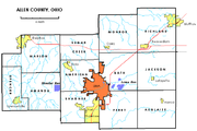
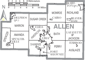
Adjacent counties
- Putnam CountyPutnam County, OhioPutnam County is a county located in the state of Ohio, United States. As of the 2010 census, the population was 34,499. The name is in honor of Israel Putnam, who was a hero in the French and Indian War and a general in the American Revolutionary War. Its county seat is...
(north) - Hancock CountyHancock County, OhioHancock County is a county located in the state of Ohio, United States. As of the 2010 census, the population was 74,782. Its county seat is Findlay and was named for John Hancock, the first signer of the Declaration of Independence...
(northeast) - Hardin CountyHardin County, OhioHardin County is a county located in the state of Ohio, United States. As of the 2010 census, the population was 32,058. Its county seat is Kenton and is named for John Hardin, an officer in the American Revolution.-Geography:According to the U.S...
(east) - Auglaize CountyAuglaize County, OhioAs of the census of 2000, there were 46,611 people, 17,376 households, and 12,771 families residing in the county. The population density was 116 people per square mile . There were 18,470 housing units at an average density of 46 per square mile...
(south) - Van Wert County (west)
Demographics
As of the censusCensus
A census is the procedure of systematically acquiring and recording information about the members of a given population. It is a regularly occurring and official count of a particular population. The term is used mostly in connection with national population and housing censuses; other common...
of 2000, there were 108,473 people, 40,646 households, and 28,208 families residing in the county. The population density
Population density
Population density is a measurement of population per unit area or unit volume. It is frequently applied to living organisms, and particularly to humans...
was 268 people per square mile (104/km²). There were 44,245 housing units at an average density of 109 per square mile (42/km²). The racial makeup of the county was 84.95% White
Race (United States Census)
Race and ethnicity in the United States Census, as defined by the Federal Office of Management and Budget and the United States Census Bureau, are self-identification data items in which residents choose the race or races with which they most closely identify, and indicate whether or not they are...
, 12.19% Black
Race (United States Census)
Race and ethnicity in the United States Census, as defined by the Federal Office of Management and Budget and the United States Census Bureau, are self-identification data items in which residents choose the race or races with which they most closely identify, and indicate whether or not they are...
or African American
Race (United States Census)
Race and ethnicity in the United States Census, as defined by the Federal Office of Management and Budget and the United States Census Bureau, are self-identification data items in which residents choose the race or races with which they most closely identify, and indicate whether or not they are...
, 0.21% Native American
Race (United States Census)
Race and ethnicity in the United States Census, as defined by the Federal Office of Management and Budget and the United States Census Bureau, are self-identification data items in which residents choose the race or races with which they most closely identify, and indicate whether or not they are...
, 0.55% Asian
Race (United States Census)
Race and ethnicity in the United States Census, as defined by the Federal Office of Management and Budget and the United States Census Bureau, are self-identification data items in which residents choose the race or races with which they most closely identify, and indicate whether or not they are...
, 0.01% Pacific Islander
Race (United States Census)
Race and ethnicity in the United States Census, as defined by the Federal Office of Management and Budget and the United States Census Bureau, are self-identification data items in which residents choose the race or races with which they most closely identify, and indicate whether or not they are...
, 0.63% from other races
Race (United States Census)
Race and ethnicity in the United States Census, as defined by the Federal Office of Management and Budget and the United States Census Bureau, are self-identification data items in which residents choose the race or races with which they most closely identify, and indicate whether or not they are...
, and 1.45% from two or more races. 1.42% of the population were Hispanic
Race (United States Census)
Race and ethnicity in the United States Census, as defined by the Federal Office of Management and Budget and the United States Census Bureau, are self-identification data items in which residents choose the race or races with which they most closely identify, and indicate whether or not they are...
or Latino
Race (United States Census)
Race and ethnicity in the United States Census, as defined by the Federal Office of Management and Budget and the United States Census Bureau, are self-identification data items in which residents choose the race or races with which they most closely identify, and indicate whether or not they are...
of any race. 33.8% were of German
Germans
The Germans are a Germanic ethnic group native to Central Europe. The English term Germans has referred to the German-speaking population of the Holy Roman Empire since the Late Middle Ages....
, 14.2% American
United States
The United States of America is a federal constitutional republic comprising fifty states and a federal district...
, 8.8% Irish
Irish people
The Irish people are an ethnic group who originate in Ireland, an island in northwestern Europe. Ireland has been populated for around 9,000 years , with the Irish people's earliest ancestors recorded having legends of being descended from groups such as the Nemedians, Fomorians, Fir Bolg, Tuatha...
and 6.6% English
English people
The English are a nation and ethnic group native to England, who speak English. The English identity is of early mediaeval origin, when they were known in Old English as the Anglecynn. England is now a country of the United Kingdom, and the majority of English people in England are British Citizens...
ancestry according to Census 2000.
There were 40,646 households out of which 32.90% had children under the age of 18 living with them, 53.00% were married couples
Marriage
Marriage is a social union or legal contract between people that creates kinship. It is an institution in which interpersonal relationships, usually intimate and sexual, are acknowledged in a variety of ways, depending on the culture or subculture in which it is found...
living together, 12.40% had a female householder with no husband present, and 30.60% were non-families. 26.30% of all households were made up of individuals and 11.20% had someone living alone who was 65 years of age or older. The average household size was 2.52 and the average family size was 3.05.
In the county the population was spread out with 25.90% under the age of 18, 9.90% from 18 to 24, 27.60% from 25 to 44, 22.40% from 45 to 64, and 14.20% who were 65 years of age or older. The median age was 36 years. For every 100 females there were 100.00 males. For every 100 females age 18 and over, there were 98.00 males.
The median income for a household in the county was $37,048, and the median income for a family was $44,723. Males had a median income of $35,546 versus $23,537 for females. The per capita income
Per capita income
Per capita income or income per person is a measure of mean income within an economic aggregate, such as a country or city. It is calculated by taking a measure of all sources of income in the aggregate and dividing it by the total population...
for the county was $17,511. About 9.60% of families and 12.10% of the population were below the poverty line, including 17.00% of those under age 18 and 9.60% of those age 65 or over.
Allen County Fair
One of the more notable annual events in Allen County is its County Fair. Run every August in Lima, OhioLima, Ohio
Lima is a city in and the county seat of Allen County, Ohio, United States. The municipality is located in northwestern Ohio along Interstate 75 approximately north of Dayton and south-southwest of Toledo....
since 1851, the Fair is amongst the foremost agricultural showcasing events in Western Ohio. In 2005, there were over 220,000 visitors and almost 3,000 exhibitors, making it the largest in the state.
The fair has also been notable for attracting many nationally known performers during the 1980s and 1990s, and combined with significant renovations to the county show grounds, these two factors have contributed to a marked increase in attendance and notoriety over the past two decades.
Cities
- DelphosDelphos, OhioDelphos is a city in Allen and Van Wert Counties in the U.S. state of Ohio. It had a population of 6,944 at the 2000 census.The Allen County portion of Delphos is part of the Lima Metropolitan Statistical Area, while the Van Wert County portion is part of the Van Wert Micropolitan Statistical...
- LimaLima, OhioLima is a city in and the county seat of Allen County, Ohio, United States. The municipality is located in northwestern Ohio along Interstate 75 approximately north of Dayton and south-southwest of Toledo....
Villages
|
Fort Shawnee, Ohio Fort Shawnee is a village in Allen County, Ohio, United States with a population of 3,855 as of the 2000 U.S. census. It is included in the Lima, Ohio Metropolitan Statistical Area... Harrod, Ohio Harrod is a village in Allen County, Ohio, United States with a population of 491 as of the 2000 U.S. census. It is included in the Lima, Ohio Metropolitan Statistical Area.-Geography:Harrod is located at .... Lafayette, Ohio Lafayette is a village in Allen County, Ohio, United States with a population of 304 as of the 2000 U.S. census. It is included in the Lima, Ohio Metropolitan Statistical Area.-Geography:Lafayette is located at .... Spencerville, Ohio Spencerville is a village in Allen County, Ohio, United States with a population of 2,235 as of the 2000 U.S. census. It is included in the Lima, Ohio Metropolitan Statistical Area.-Geography:Spencerville is located at .... |
Townships
|
Monroe Township, Allen County, Ohio Monroe Township is one of the twelve townships of Allen County, Ohio, United States. The 2000 census found 2,219 people in the township, 1,720 of whom lived in the unincorporated portions of the township.-Geography:... Perry Township, Allen County, Ohio Perry Township is one of the twelve townships of Allen County, Ohio, United States. The 2000 census found 3,620 people in the unincorporated parts of the township.-Geography:Located in the southern part of the county, it borders the following townships:... Richland Township, Allen County, Ohio Richland Township is one of the twelve townships of Allen County, Ohio, United States. The 2000 census found 6,090 people in the township, 2,015 of whom lived in the unincorporated portions of the township.-Geography:... Shawnee Township, Allen County, Ohio Shawnee Township is one of the twelve townships of Allen County, Ohio, United States. The 2000 census found 12,220 people in the township, 8,365 of whom lived in the unincorporated portions of the township.-Geography:... Spencer Township, Allen County, Ohio Spencer Township is one of the twelve townships of Allen County, Ohio, United States. The 2000 census found 3,106 people in the township, 871 of whom lived in the unincorporated portions of the township.-Geography:... Sugar Creek Township, Allen County, Ohio Sugar Creek Township is one of the twelve townships of Allen County, Ohio, United States. The 2000 census found 1,330 people in the township.-Geography:Located in the northern part of the county, it borders the following townships:... |
Unincorporated communities
|
Westminster, Ohio Westminster is an unincorporated community in western Auglaize Township, Allen County, Ohio, United States. It lies along State Route 117 just north of its intersection with State Route 196, 6½ miles north of Waynesfield and 7½ miles southeast of the downtown part of the city of Lima, the county... |