
Lake County, Ohio
Encyclopedia
Lake County is a county located in the U.S. state
of Ohio
. As of 2010, the population was 230,041. http://quickfacts.census.gov/qfd/states/39/39085.html The county seat
is Painesville
, and the county name comes from its location on the southern shore of Lake Erie
.
Lake County is part of the Cleveland
–Elyria
–Mentor
Metropolitan Statistical Area
.
, the county has a total area of 979 square miles (2,535.6 km²). 228 square miles (590.5 km²) is land and 751 square miles (1,945.1 km²) (76.69%) is water. Lake County is Ohio's smallest county by land area.
of 2000, there were 227,511 people, 89,700 households, and 62,520 families residing in the county. The population density
was 997 people per square mile (385/km²). There were 93,487 housing units at an average density of 410 per square mile (158/km²). The racial makeup of the county was 95.40% White
, 1.99% Black
or African American
, 0.11% Native American
, 0.90% Asian
, 0.02% Pacific Islander
, 0.66% from other races
, and 0.92% from two or more races. 1.70% of the population were Hispanic
or Latino
of any race. 18.5% were of German
, 14.6% Italian
, 12.7% Irish
, 8.1% English
, 6.2% Polish, 5.7% American
and 5.4% Slovene ancestry according to Census 2000. 93.6% spoke English
and 1.9% Spanish
as their first language.
There were 89,700 households out of which 31.10% had children under the age of 18 living with them, 56.10% were married couples
living together, 10.00% had a female householder with no husband present, and 30.30% were non-families. 25.60% of all households were made up of individuals and 9.80% had someone living alone who was 65 years of age or older. The average household size was 2.50 and the average family size was 3.03.
In the county, the population was spread out with 24.20% under the age of 18, 7.30% from 18 to 24, 29.70% from 25 to 44, 24.70% from 45 to 64, and 14.10% who were 65 years of age or older. The median age was 39 years. For every 100 females there were 94.50 males. For every 100 females age 18 and over, there were 91.50 males.
The median income for a household in the county was $48,763, and the median income for a family was $57,134. Males had a median income of $40,916 versus $28,434 for females. The per capita income
for the county was $23,160. About 3.50% of families and 5.10% of the population were below the poverty line, including 6.50% of those under age 18 and 5.40% of those age 65 or over.
Lake County has a large public park system. Kirtland
is home to the Holden Arboretum
and the location of Gildersleeve Mountain
. Headlands Beach State Park
is located in Mentor
. The Grand River
is a state wild and scenic river and the Chagrin River
is a state scenic river.
is the transit agency servicing Lake County. Interstate 90
runs northeast/southwest through Lake County, roughly parallel to State Route 2; together these roads make up the major traffic arteries in the county. There is currently no passenger rail service in Lake County.
U.S. state
A U.S. state is any one of the 50 federated states of the United States of America that share sovereignty with the federal government. Because of this shared sovereignty, an American is a citizen both of the federal entity and of his or her state of domicile. Four states use the official title of...
of Ohio
Ohio
Ohio is a Midwestern state in the United States. The 34th largest state by area in the U.S.,it is the 7th‑most populous with over 11.5 million residents, containing several major American cities and seven metropolitan areas with populations of 500,000 or more.The state's capital is Columbus...
. As of 2010, the population was 230,041. http://quickfacts.census.gov/qfd/states/39/39085.html The county seat
County seat
A county seat is an administrative center, or seat of government, for a county or civil parish. The term is primarily used in the United States....
is Painesville
Painesville, Ohio
As of the 2010 Census, there were 19,563 people. As of the census of 2000, there were 17,503 people, 6,525 households, and 4,032 families residing in the city. The population density was 2,928.6 people per square mile . There were 6,933 housing units at an average density of 1,160.0 per square mile...
, and the county name comes from its location on the southern shore of Lake Erie
Lake Erie
Lake Erie is the fourth largest lake of the five Great Lakes in North America, and the tenth largest globally. It is the southernmost, shallowest, and smallest by volume of the Great Lakes and therefore also has the shortest average water residence time. It is bounded on the north by the...
.
Lake County is part of the Cleveland
Cleveland, Ohio
Cleveland is a city in the U.S. state of Ohio and is the county seat of Cuyahoga County, the most populous county in the state. The city is located in northeastern Ohio on the southern shore of Lake Erie, approximately west of the Pennsylvania border...
–Elyria
Elyria, Ohio
-Community:Elyria has an extensive, although financially burdened, community food pantry and "Hot Meals" program administered through the Second Harvest Food Bank and several churches Elyria is served by Elyria Memorial Hospital.-Recreation and parks:...
–Mentor
Mentor, Ohio
As of the census of 2000, there were 50,278 people, 18,797 households, and 14,229 families residing in the city. The population density was 1,878.2 people per square mile . There were 19,301 housing units at an average density of 721.0 per square mile...
Metropolitan Statistical Area
Greater Cleveland
Greater Cleveland is a nickname for the metropolitan area surrounding Cleveland, Ohio and is part of what used to be the Connecticut Western Reserve.Northeast Ohio refers to a similar but substantially larger area as described below...
.
Geography
According to the U.S. Census BureauUnited States Census Bureau
The United States Census Bureau is the government agency that is responsible for the United States Census. It also gathers other national demographic and economic data...
, the county has a total area of 979 square miles (2,535.6 km²). 228 square miles (590.5 km²) is land and 751 square miles (1,945.1 km²) (76.69%) is water. Lake County is Ohio's smallest county by land area.
Adjacent counties
- Across Lake ErieLake ErieLake Erie is the fourth largest lake of the five Great Lakes in North America, and the tenth largest globally. It is the southernmost, shallowest, and smallest by volume of the Great Lakes and therefore also has the shortest average water residence time. It is bounded on the north by the...
lies Elgin CountyElgin County, OntarioElgin County is a county and census division of the Canadian province of Ontario with a current population of approximately 46,000. The county seat is St. Thomas.It consists of:*Town of Aylmer*Municipality of Bayham*Municipality of Central Elgin...
, OntarioOntarioOntario is a province of Canada, located in east-central Canada. It is Canada's most populous province and second largest in total area. It is home to the nation's most populous city, Toronto, and the nation's capital, Ottawa....
, CanadaCanadaCanada is a North American country consisting of ten provinces and three territories. Located in the northern part of the continent, it extends from the Atlantic Ocean in the east to the Pacific Ocean in the west, and northward into the Arctic Ocean...
(north) - Ashtabula CountyAshtabula County, OhioAshtabula County is the northeasternmost county in the state of Ohio. As of 2010, the population was 101,497, its county seat is Jefferson. The county is named for a Native American word meaning "river of many fish"....
(east) - Geauga CountyGeauga County, OhioGeauga County is a county located in the state of Ohio, United States. As of the 2010 census, the population was 93,389. It is named for a Native American word meaning "raccoon". The county seat is Chardon...
(south and east) - Cuyahoga CountyCuyahoga County, OhioCuyahoga County is a county located in the state of Ohio, United States. It is the most populous county in Ohio; as of the 2010 census, the population was 1,280,122. Its county seat is Cleveland. Cuyahoga County is part of Greater Cleveland, a metropolitan area, and Northeast Ohio, a...
(south and west)
Demographics
As of the censusCensus
A census is the procedure of systematically acquiring and recording information about the members of a given population. It is a regularly occurring and official count of a particular population. The term is used mostly in connection with national population and housing censuses; other common...
of 2000, there were 227,511 people, 89,700 households, and 62,520 families residing in the county. The population density
Population density
Population density is a measurement of population per unit area or unit volume. It is frequently applied to living organisms, and particularly to humans...
was 997 people per square mile (385/km²). There were 93,487 housing units at an average density of 410 per square mile (158/km²). The racial makeup of the county was 95.40% White
Race (United States Census)
Race and ethnicity in the United States Census, as defined by the Federal Office of Management and Budget and the United States Census Bureau, are self-identification data items in which residents choose the race or races with which they most closely identify, and indicate whether or not they are...
, 1.99% Black
Race (United States Census)
Race and ethnicity in the United States Census, as defined by the Federal Office of Management and Budget and the United States Census Bureau, are self-identification data items in which residents choose the race or races with which they most closely identify, and indicate whether or not they are...
or African American
Race (United States Census)
Race and ethnicity in the United States Census, as defined by the Federal Office of Management and Budget and the United States Census Bureau, are self-identification data items in which residents choose the race or races with which they most closely identify, and indicate whether or not they are...
, 0.11% Native American
Race (United States Census)
Race and ethnicity in the United States Census, as defined by the Federal Office of Management and Budget and the United States Census Bureau, are self-identification data items in which residents choose the race or races with which they most closely identify, and indicate whether or not they are...
, 0.90% Asian
Race (United States Census)
Race and ethnicity in the United States Census, as defined by the Federal Office of Management and Budget and the United States Census Bureau, are self-identification data items in which residents choose the race or races with which they most closely identify, and indicate whether or not they are...
, 0.02% Pacific Islander
Race (United States Census)
Race and ethnicity in the United States Census, as defined by the Federal Office of Management and Budget and the United States Census Bureau, are self-identification data items in which residents choose the race or races with which they most closely identify, and indicate whether or not they are...
, 0.66% from other races
Race (United States Census)
Race and ethnicity in the United States Census, as defined by the Federal Office of Management and Budget and the United States Census Bureau, are self-identification data items in which residents choose the race or races with which they most closely identify, and indicate whether or not they are...
, and 0.92% from two or more races. 1.70% of the population were Hispanic
Race (United States Census)
Race and ethnicity in the United States Census, as defined by the Federal Office of Management and Budget and the United States Census Bureau, are self-identification data items in which residents choose the race or races with which they most closely identify, and indicate whether or not they are...
or Latino
Race (United States Census)
Race and ethnicity in the United States Census, as defined by the Federal Office of Management and Budget and the United States Census Bureau, are self-identification data items in which residents choose the race or races with which they most closely identify, and indicate whether or not they are...
of any race. 18.5% were of German
Germans
The Germans are a Germanic ethnic group native to Central Europe. The English term Germans has referred to the German-speaking population of the Holy Roman Empire since the Late Middle Ages....
, 14.6% Italian
Italian people
The Italian people are an ethnic group that share a common Italian culture, ancestry and speak the Italian language as a mother tongue. Within Italy, Italians are defined by citizenship, regardless of ancestry or country of residence , and are distinguished from people...
, 12.7% Irish
Irish people
The Irish people are an ethnic group who originate in Ireland, an island in northwestern Europe. Ireland has been populated for around 9,000 years , with the Irish people's earliest ancestors recorded having legends of being descended from groups such as the Nemedians, Fomorians, Fir Bolg, Tuatha...
, 8.1% English
English people
The English are a nation and ethnic group native to England, who speak English. The English identity is of early mediaeval origin, when they were known in Old English as the Anglecynn. England is now a country of the United Kingdom, and the majority of English people in England are British Citizens...
, 6.2% Polish, 5.7% American
United States
The United States of America is a federal constitutional republic comprising fifty states and a federal district...
and 5.4% Slovene ancestry according to Census 2000. 93.6% spoke English
English language
English is a West Germanic language that arose in the Anglo-Saxon kingdoms of England and spread into what was to become south-east Scotland under the influence of the Anglian medieval kingdom of Northumbria...
and 1.9% Spanish
Spanish language
Spanish , also known as Castilian , is a Romance language in the Ibero-Romance group that evolved from several languages and dialects in central-northern Iberia around the 9th century and gradually spread with the expansion of the Kingdom of Castile into central and southern Iberia during the...
as their first language.
There were 89,700 households out of which 31.10% had children under the age of 18 living with them, 56.10% were married couples
Marriage
Marriage is a social union or legal contract between people that creates kinship. It is an institution in which interpersonal relationships, usually intimate and sexual, are acknowledged in a variety of ways, depending on the culture or subculture in which it is found...
living together, 10.00% had a female householder with no husband present, and 30.30% were non-families. 25.60% of all households were made up of individuals and 9.80% had someone living alone who was 65 years of age or older. The average household size was 2.50 and the average family size was 3.03.
In the county, the population was spread out with 24.20% under the age of 18, 7.30% from 18 to 24, 29.70% from 25 to 44, 24.70% from 45 to 64, and 14.10% who were 65 years of age or older. The median age was 39 years. For every 100 females there were 94.50 males. For every 100 females age 18 and over, there were 91.50 males.
The median income for a household in the county was $48,763, and the median income for a family was $57,134. Males had a median income of $40,916 versus $28,434 for females. The per capita income
Per capita income
Per capita income or income per person is a measure of mean income within an economic aggregate, such as a country or city. It is calculated by taking a measure of all sources of income in the aggregate and dividing it by the total population...
for the county was $23,160. About 3.50% of families and 5.10% of the population were below the poverty line, including 6.50% of those under age 18 and 5.40% of those age 65 or over.
Environment
Scorecard ranks Lake County among the worst 10% of counties in the U.S. in terms of cancer risk, developmental and reproductive toxicants, and other categories as well; this is comparable with most major cities and densely populated areas.Lake County has a large public park system. Kirtland
Kirtland, Ohio
Kirtland is a city in Lake County, Ohio, USA. The population was 6,670 at the 2000 census. Kirtland is famous for being the early headquarters of the Latter Day Saint movement.-Origins of Kirtland:...
is home to the Holden Arboretum
Holden Arboretum
The Holden Arboretum, in Kirtland, Ohio, USA, is one of the largest arboretums and botanical gardens in the United States, with over 3,500 acres , 600 acres of which are devoted to collections and gardens. Diverse natural areas and ecologically sensitive habitats make up the rest of the holdings...
and the location of Gildersleeve Mountain
Gildersleeve Mountain
Gildersleeve Mountain is a summit located in Kirtland, Ohio, United States.Gildersleeve Mountain is interesting and important because it is within one of the largest and most densely populated metropolitan areas in the United States . It is a relatively unspoiled and unique area just from downtown...
. Headlands Beach State Park
Headlands Beach State Park
Headlands Beach State Park is a public beach in Mentor and Painesville Township, Ohio, USA. It is the longest natural beach on Lake Erie. The Cleveland The Plain Dealer ranked Headlands as Ohio's Best Beach....
is located in Mentor
Mentor, Ohio
As of the census of 2000, there were 50,278 people, 18,797 households, and 14,229 families residing in the city. The population density was 1,878.2 people per square mile . There were 19,301 housing units at an average density of 721.0 per square mile...
. The Grand River
Grand River (Ohio)
The Grand River is a tributary of Lake Erie, 102.7 miles long, in northeastern Ohio in the United States. Via Lake Erie, the Niagara River and Lake Ontario, it is part of the watershed of the St. Lawrence River, which flows to the Atlantic Ocean...
is a state wild and scenic river and the Chagrin River
Chagrin River
The Chagrin River is located in Northeast Ohio. The river has two branches, the Aurora Branch and East Branch. Its name is believed to stem from what the local Erie Indians used to call it, the "Sha-ga-rin", or "Clear Water". Given the clear flowing nature of especially the East Branch of the...
is a state scenic river.
Transportation
LaketranLaketran
Laketran is the transit agency servicing Lake County, Ohio, the county northeast of Cleveland. It is the third-largest transit system in Northeast Ohio, serving Mentor, Painesville, Willoughby, Wickliffe. Eastlake, Fairport Harbor, Madison and other Lake County destinations.Laketran was established...
is the transit agency servicing Lake County. Interstate 90
Interstate 90
Interstate 90 is the longest Interstate Highway in the United States at . It is the northernmost coast-to-coast interstate, and parallels US 20 for the most part. Its western terminus is in Seattle, at Edgar Martinez Drive S. near Safeco Field and CenturyLink Field, and its eastern terminus is in...
runs northeast/southwest through Lake County, roughly parallel to State Route 2; together these roads make up the major traffic arteries in the county. There is currently no passenger rail service in Lake County.
Library services
Lake County is served by the following libraries:- Fairport Harbor Public Library in Fairport HarborFairport Harbor, OhioFairport Harbor is a village in Lake County, Ohio, United States, along Lake Erie at the mouth of the Grand River. The population was 3,180 at the 2000 census....
- Kirtland Public Library in KirtlandKirtland, OhioKirtland is a city in Lake County, Ohio, USA. The population was 6,670 at the 2000 census. Kirtland is famous for being the early headquarters of the Latter Day Saint movement.-Origins of Kirtland:...
- Madison Public Library in MadisonMadison, OhioMadison is a village in Lake County, Ohio, in the United States. As of the 2000 census, the village population was 2,921.-Geography:Madison is located at .According to the United States Census Bureau, the village has a total area of , all of it land....
- Mentor Public LibraryMentor Public LibraryMentor Public Library is a public library in Lake County, Ohio. It has branches in Mentor and Mentor-on-the-Lake. The library has 59,842 registered patrons and a collection size of 250,000 volumes...
in MentorMentor, OhioAs of the census of 2000, there were 50,278 people, 18,797 households, and 14,229 families residing in the city. The population density was 1,878.2 people per square mile . There were 19,301 housing units at an average density of 721.0 per square mile... - Morley LibraryMorley LibraryMorley Library, located at 184 Phelps St. in Painesville, Ohio serves as the County District Library for Lake County, Ohio. Morley Library is a medium-sized public library that is supported by both state funds and a local tax levy. The original library was founded in 1899...
in PainesvillePainesville, OhioAs of the 2010 Census, there were 19,563 people. As of the census of 2000, there were 17,503 people, 6,525 households, and 4,032 families residing in the city. The population density was 2,928.6 people per square mile . There were 6,933 housing units at an average density of 1,160.0 per square mile... - Perry Public Library in PerryPerry, OhioPerry is a village in Lake County, Ohio, United States. The population was 1,195 at the 2000 census. It is named in honor of Commodore Oliver Hazard Perry to commemorate his victory over the British fleet at the Battle of Lake Erie in September 1813. The battle was a turning point in the western...
- Wickliffe Public Library in WickliffeWickliffe, OhioAs of the census of 2000, there are 13,484 people, 5,604 households, 3,754 families residing in the city. The population density is 2,898.2 people per square mile . There are 5,787 housing units at an average density of 1,243.8 per square mile...
. WKPL is "A Top Ten American Library" as rated by the HAPLR Index. In 2005, the library loaned more than 459,000 items to its 110,400 cardholders. Total holdings are over 100,000 volumes with over 519 periodical subscriptions. - Willoughby-Eastlake Public Library, headquartered in WillowickWillowick, OhioAs of the census of 2000, there were 14,361 people, 6,101 households, and 4,112 families residing in the city. The population density was 5,709.2 people per square mile . There were 6,272 housing units at an average density of 2,493.4 per square mile...
with branches in EastlakeEastlake, OhioAs of the census of 2000, there were 20,255 people, 8,055 households, and 5,557 families residing in the city. The population density was 3,166.5 people per square mile . There were 8,310 housing units at an average density of 1,299.1 per square mile...
, WilloughbyWilloughby, OhioAs of the census of 2000, there were 22,621 people, 10,265 households, and 5,892 families residing in the city. The population density was 2,225.3 people per square mile . There were 10,700 housing units at an average density of 1,052.6 per square mile...
, and Willoughby HillsWilloughby Hills, OhioWilloughby Hills is a city in Lake County, Ohio, United States. The population was 8,595 at the 2000 census.-Geography:Willoughby Hills is located at ....
. In 2005, the library loaned more than 1.2 million items to its 37,000 cardholders. Total holding are over 216,000 volumes with over 850 periodical subscriptions.
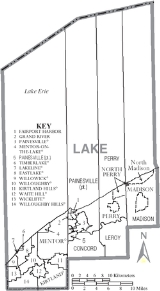
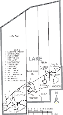
Localities
Municipalities
|
Lakeline, Ohio Lakeline is a village in Lake County, Ohio, United States. The population was 165 at the 2000 census.-Geography:Lakeline is located at .According to the United States Census Bureau, the village has a total area of , all of it land.... Madison, Ohio Madison is a village in Lake County, Ohio, in the United States. As of the 2000 census, the village population was 2,921.-Geography:Madison is located at .According to the United States Census Bureau, the village has a total area of , all of it land.... Mentor, Ohio As of the census of 2000, there were 50,278 people, 18,797 households, and 14,229 families residing in the city. The population density was 1,878.2 people per square mile . There were 19,301 housing units at an average density of 721.0 per square mile... Mentor-on-the-Lake, Ohio Mentor-on-the-Lake is a city in Lake County, Ohio, United States. The population was 8,127 at the 2000 census.-Geography:Mentor-on-the-Lake is located at .... North Perry, Ohio North Perry is a village in Lake County, Ohio, United States. The population was 838 at the 2000 census.-Geography:North Perry is located at... |
Painesville, Ohio As of the 2010 Census, there were 19,563 people. As of the census of 2000, there were 17,503 people, 6,525 households, and 4,032 families residing in the city. The population density was 2,928.6 people per square mile . There were 6,933 housing units at an average density of 1,160.0 per square mile... Perry, Ohio Perry is a village in Lake County, Ohio, United States. The population was 1,195 at the 2000 census. It is named in honor of Commodore Oliver Hazard Perry to commemorate his victory over the British fleet at the Battle of Lake Erie in September 1813. The battle was a turning point in the western... Timberlake, Ohio Timberlake is a village in Lake County, Ohio, United States. The population was 775 at the 2000 census.-Geography:Timberlake is located at .... Waite Hill, Ohio Waite Hill is a village in Lake County, Ohio, United States. The population was 446 at the 2000 census.-Geography:Waite Hill is located at .... |
Wickliffe, Ohio As of the census of 2000, there are 13,484 people, 5,604 households, 3,754 families residing in the city. The population density is 2,898.2 people per square mile . There are 5,787 housing units at an average density of 1,243.8 per square mile... Willoughby, Ohio As of the census of 2000, there were 22,621 people, 10,265 households, and 5,892 families residing in the city. The population density was 2,225.3 people per square mile . There were 10,700 housing units at an average density of 1,052.6 per square mile... Willoughby Hills, Ohio Willoughby Hills is a city in Lake County, Ohio, United States. The population was 8,595 at the 2000 census.-Geography:Willoughby Hills is located at .... Willowick, Ohio As of the census of 2000, there were 14,361 people, 6,101 households, and 4,112 families residing in the city. The population density was 5,709.2 people per square mile . There were 6,272 housing units at an average density of 2,493.4 per square mile... |
Townships
- ConcordConcord Township, Lake County, OhioConcord Township is one of the five townships of Lake County, Ohio, United States. The 2000 census found 15,828 people in the township.-Geography:Located in the center of the county, it borders the following townships and municipalities:...
- LeRoyLeRoy Township, Lake County, OhioLeRoy Township is one of the five townships of Lake County, Ohio, United States. The 2000 census found 3,122 people in the township.-Geography:Located in the eastern part of the county, it borders the following townships:*Perry Township - north...
- MadisonMadison Township, Lake County, OhioMadison Township is one of the five townships of Lake County, Ohio, United States. The 2000 census found 18,428 people in the township, 15,494 of whom lived in the unincorporated portions of the township.-Geography:...
- PainesvillePainesville Township, Lake County, OhioPainesville Township is one of the five townships of Lake County, Ohio, United States. The 2000 census found 18,562 people in the township, 15,037 of whom lived in the unincorporated portions of the township.-Geography:...
- PerryPerry Township, Lake County, OhioPerry Township is one of the five townships of Lake County, Ohio, United States. The 2000 census found 8,240 people in the township, 6,220 of whom lived in the unincorporated portions of the township.-Geography:...
Other places
- Painesville-on-the-LakePainesville-on-the-Lake, OhioPainesville-on-the-Lake is an unincorporated community in northern Painesville Township, Lake County, Ohio, United States. It lies along the shoreline of Lake Erie north of the county seat of Painesville. The short Hardy Road connects the community to State Route 535.-External links:*...
- UnionvilleUnionville, OhioUnionville is an unincorporated community on the line between northwestern Harpersfield Township in Ashtabula County and eastern Madison Township in Lake County in the U.S. state of Ohio. Although it is unincorporated, it has a post office, with the ZIP code of 44088...
See also
- Melon headsMelon headsMelon Heads is the name given to legendary beings and urban legends in parts of Michigan, Ohio, and Connecticut generally described as small humanoids with bulbous heads who occasionally emerge from hiding places to attack people...
- a local urban legend - National Register of Historic Places listings in Lake County, Ohio