

Richland County, Ohio
Encyclopedia
Richland County is a county located in the state
of Ohio
, United States
. As of the 2010 census, the population was 124,475. http://quickfacts.census.gov/qfd/states/39/39139.html It is included in the Mansfield, Ohio
, Metropolitan Statistical Area as well as the Mansfield–Bucyrus
Combined Statistical Area
.
It is named for the fertile soil found there. Its county seat
is Mansfield
.
, the county has a total area of 500 square miles (1,295 km²).497 square miles (1,287 km²) of it is land and 3 square miles (7.8 km²) of it (0.69%) is water.
of 2000, there were 128,852 people, 49,534 households, and 34,277 families residing in the county. The population density
was 259 people per square mile (100/km²). There were 53,062 housing units at an average density of 107 per square mile (41/km²). The racial makeup of the county was 88.16% White
, 9.43% Black
or African American
, 0.20% Native American
, 0.51% Asian
, 0.03% Pacific Islander
, 0.38% from other races
, and 1.28% from two or more races. 0.93% of the population were Hispanic
or Latino
of any race. 96.0% spoke English
, 1.2% German
and 1.2% Spanish
as their first language.
There were 49,534 households out of which 30.90% had children under the age of 18 living with them, 54.30% were married couples
living together, 11.40% had a female householder with no husband present, and 30.80% were non-families. 26.50% of all households were made up of individuals and 10.90% had someone living alone who was 65 years of age or older. The average household size was 2.47 and the average family size was 2.98.
In the county, the population was spread out with 24.80% under the age of 18, 8.40% from 18 to 24, 28.60% from 25 to 44, 24.10% from 45 to 64, and 14.20% who were 65 years of age or older. The median age was 38 years. For every 100 females there were 101.30 males. For every 100 females age 18 and over, there were 99.30 males.
The median income for a household in the county was $37,397, and the median income for a family was $45,036. Males had a median income of $35,425 versus $22,859 for females. The per capita income
for the county was $18,582. About 8.20% of families and 10.60% of the population were below the poverty line, including 15.30% of those under age 18 and 7.70% of those age 65 or over.
U.S. state
A U.S. state is any one of the 50 federated states of the United States of America that share sovereignty with the federal government. Because of this shared sovereignty, an American is a citizen both of the federal entity and of his or her state of domicile. Four states use the official title of...
of Ohio
Ohio
Ohio is a Midwestern state in the United States. The 34th largest state by area in the U.S.,it is the 7th‑most populous with over 11.5 million residents, containing several major American cities and seven metropolitan areas with populations of 500,000 or more.The state's capital is Columbus...
, United States
United States
The United States of America is a federal constitutional republic comprising fifty states and a federal district...
. As of the 2010 census, the population was 124,475. http://quickfacts.census.gov/qfd/states/39/39139.html It is included in the Mansfield, Ohio
Mansfield, Ohio
Mansfield is a city in the U.S. state of Ohio and the county seat of Richland County. The municipality is located in north-central Ohio in the western foothills of the Allegheny Plateau, approximately southwest of Cleveland and northeast of Columbus....
, Metropolitan Statistical Area as well as the Mansfield–Bucyrus
Bucyrus, Ohio
As of the census of 2000, there were 13,224 people, 5,559 households, and 3,552 families residing in the city. The population density was 1,812.0 people per square mile . There were 5,955 housing units at an average density of 816.0 per square mile...
Combined Statistical Area
Mansfield-Bucyrus, OH Combined Statistical Area
The Mansfield–Bucyrus, OH Combined Statistical Area is a CSA in the U.S. state of Ohio, as defined by the United States Census Bureau. It consists of the Mansfield Metropolitan Statistical Area ; and the Bucyrus Micropolitan Statistical Area...
.
It is named for the fertile soil found there. Its county seat
County seat
A county seat is an administrative center, or seat of government, for a county or civil parish. The term is primarily used in the United States....
is Mansfield
Mansfield, Ohio
Mansfield is a city in the U.S. state of Ohio and the county seat of Richland County. The municipality is located in north-central Ohio in the western foothills of the Allegheny Plateau, approximately southwest of Cleveland and northeast of Columbus....
.
Geography
According to the U.S. Census BureauUnited States Census Bureau
The United States Census Bureau is the government agency that is responsible for the United States Census. It also gathers other national demographic and economic data...
, the county has a total area of 500 square miles (1,295 km²).497 square miles (1,287 km²) of it is land and 3 square miles (7.8 km²) of it (0.69%) is water.
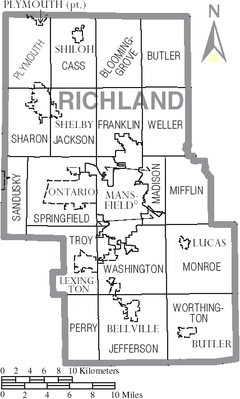
Adjacent counties
- Huron CountyHuron County, OhioAs of the census of 2000, there were 59,487 people, 22,307 households, and 16,217 families residing in the county. The population density was 121 people per square mile . There were 23,594 housing units at an average density of 48 per square mile...
(north) - Ashland CountyAshland County, OhioAshland County is a county located in the state of Ohio, United States, and was formed in 1846 from parts of Huron, Lorain, Richland and Wayne Counties. As of the 2010 census, the population was 53,139. Its county seat is Ashland...
(east) - Knox CountyKnox County, OhioKnox County is a county located in the state of Ohio, United States. As of 2010, the population was 60,921. Its county seat is Mount Vernon and is named for Henry Knox, an officer in the American Revolutionary War who was later the first Secretary of War....
(south) - Morrow CountyMorrow County, OhioMorrow County is a county located in the state of Ohio, United States. Shawnee people used the area for hunting purposes before white settlers arrived in the early 19th century. Morrow County was organized in 1848 from parts of four neighboring counties and named for Jeremiah Morrow, Governor of...
(southwest) - Crawford CountyCrawford County, OhioCrawford County is a county located in the state of Ohio, United States. It was named for Colonel William Crawford, a soldier during the American Revolution....
(west)
Demographics
As of the censusCensus
A census is the procedure of systematically acquiring and recording information about the members of a given population. It is a regularly occurring and official count of a particular population. The term is used mostly in connection with national population and housing censuses; other common...
of 2000, there were 128,852 people, 49,534 households, and 34,277 families residing in the county. The population density
Population density
Population density is a measurement of population per unit area or unit volume. It is frequently applied to living organisms, and particularly to humans...
was 259 people per square mile (100/km²). There were 53,062 housing units at an average density of 107 per square mile (41/km²). The racial makeup of the county was 88.16% White
Race (United States Census)
Race and ethnicity in the United States Census, as defined by the Federal Office of Management and Budget and the United States Census Bureau, are self-identification data items in which residents choose the race or races with which they most closely identify, and indicate whether or not they are...
, 9.43% Black
Race (United States Census)
Race and ethnicity in the United States Census, as defined by the Federal Office of Management and Budget and the United States Census Bureau, are self-identification data items in which residents choose the race or races with which they most closely identify, and indicate whether or not they are...
or African American
Race (United States Census)
Race and ethnicity in the United States Census, as defined by the Federal Office of Management and Budget and the United States Census Bureau, are self-identification data items in which residents choose the race or races with which they most closely identify, and indicate whether or not they are...
, 0.20% Native American
Race (United States Census)
Race and ethnicity in the United States Census, as defined by the Federal Office of Management and Budget and the United States Census Bureau, are self-identification data items in which residents choose the race or races with which they most closely identify, and indicate whether or not they are...
, 0.51% Asian
Race (United States Census)
Race and ethnicity in the United States Census, as defined by the Federal Office of Management and Budget and the United States Census Bureau, are self-identification data items in which residents choose the race or races with which they most closely identify, and indicate whether or not they are...
, 0.03% Pacific Islander
Race (United States Census)
Race and ethnicity in the United States Census, as defined by the Federal Office of Management and Budget and the United States Census Bureau, are self-identification data items in which residents choose the race or races with which they most closely identify, and indicate whether or not they are...
, 0.38% from other races
Race (United States Census)
Race and ethnicity in the United States Census, as defined by the Federal Office of Management and Budget and the United States Census Bureau, are self-identification data items in which residents choose the race or races with which they most closely identify, and indicate whether or not they are...
, and 1.28% from two or more races. 0.93% of the population were Hispanic
Race (United States Census)
Race and ethnicity in the United States Census, as defined by the Federal Office of Management and Budget and the United States Census Bureau, are self-identification data items in which residents choose the race or races with which they most closely identify, and indicate whether or not they are...
or Latino
Race (United States Census)
Race and ethnicity in the United States Census, as defined by the Federal Office of Management and Budget and the United States Census Bureau, are self-identification data items in which residents choose the race or races with which they most closely identify, and indicate whether or not they are...
of any race. 96.0% spoke English
English language
English is a West Germanic language that arose in the Anglo-Saxon kingdoms of England and spread into what was to become south-east Scotland under the influence of the Anglian medieval kingdom of Northumbria...
, 1.2% German
German language
German is a West Germanic language, related to and classified alongside English and Dutch. With an estimated 90 – 98 million native speakers, German is one of the world's major languages and is the most widely-spoken first language in the European Union....
and 1.2% Spanish
Spanish language
Spanish , also known as Castilian , is a Romance language in the Ibero-Romance group that evolved from several languages and dialects in central-northern Iberia around the 9th century and gradually spread with the expansion of the Kingdom of Castile into central and southern Iberia during the...
as their first language.
There were 49,534 households out of which 30.90% had children under the age of 18 living with them, 54.30% were married couples
Marriage
Marriage is a social union or legal contract between people that creates kinship. It is an institution in which interpersonal relationships, usually intimate and sexual, are acknowledged in a variety of ways, depending on the culture or subculture in which it is found...
living together, 11.40% had a female householder with no husband present, and 30.80% were non-families. 26.50% of all households were made up of individuals and 10.90% had someone living alone who was 65 years of age or older. The average household size was 2.47 and the average family size was 2.98.
In the county, the population was spread out with 24.80% under the age of 18, 8.40% from 18 to 24, 28.60% from 25 to 44, 24.10% from 45 to 64, and 14.20% who were 65 years of age or older. The median age was 38 years. For every 100 females there were 101.30 males. For every 100 females age 18 and over, there were 99.30 males.
The median income for a household in the county was $37,397, and the median income for a family was $45,036. Males had a median income of $35,425 versus $22,859 for females. The per capita income
Per capita income
Per capita income or income per person is a measure of mean income within an economic aggregate, such as a country or city. It is calculated by taking a measure of all sources of income in the aggregate and dividing it by the total population...
for the county was $18,582. About 8.20% of families and 10.60% of the population were below the poverty line, including 15.30% of those under age 18 and 7.70% of those age 65 or over.
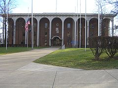
Government
Roster of county officials
- Commissioners: Ed Olson, Gary Utt, Tim Wert
- Prosecutor: James J. Mayer, Jr.
- Sheriff: J. Steve Sheldon
- Auditor: Patrick W. Dropsey
- Recorder: Sarah Davis
- Clerk of Courts: Linda H. Frary
- Engineer: Tom Beck
- Judges of the Court of Common PleasOhio Courts of Common PleasThe Ohio Courts of Common Pleas are the trial courts of the state court system of Ohio.The courts of common pleas are the trial courts of general jurisdiction in the state. They are the only trial courts created by the Ohio Constitution . The duties of the courts are outlined in Article IV, Section...
: James DeWeese and James D. Henson; Robert L. Konstam (domestic):
Communities
Cities
|
Mansfield, Ohio Mansfield is a city in the U.S. state of Ohio and the county seat of Richland County. The municipality is located in north-central Ohio in the western foothills of the Allegheny Plateau, approximately southwest of Cleveland and northeast of Columbus.... Ontario, Ohio As of the census of 2000, there were 5,303 people, 2,186 households, and 1,554 families residing in the city. The population density was 485.7 people per square mile . The racial makeup of the city was 92.36% White, 4.11% African American, 0.04% Native American, 1.58% Asian, 0.04% Pacific Islander,... |
Shelby, Ohio Shelby is a city in Richland County in the U.S. state of Ohio, northwest of the city of Mansfield. It is part of the Mansfield, Ohio Metropolitan Statistical Area. The population was 9,821 at the 2000 census.-History:... |
Villages
|
Lexington, Ohio Lexington is a village in Richland County in the U.S. state of Ohio. It is part of the Mansfield, Ohio Metropolitan Statistical Area. The population was 4,822 at the 2010 census, an increase from 4,165 in 2000.... Lucas, Ohio Lucas is a village in Richland County, Ohio, United States.Lucas was founded in 1836, and is part of the Mansfield, Ohio Metropolitan Statistical Area. The population was 620 at the 2000 census.... |
Plymouth, Ohio Plymouth is a village in Huron and Richland counties in the U.S. state of Ohio. The population was 1,852 at the 2000 census.The Richland County portion of Plymouth is part of the Mansfield Metropolitan Statistical Area, while the Huron County portion is part of the Norwalk Micropolitan Statistical... (part) Shiloh, Richland County, Ohio Shiloh is a village in Richland County in the U.S. state of Ohio. It is part of the Mansfield, Ohio Metropolitan Statistical Area. The population was 721 at the 2000 census.-Geography:Shiloh is located at .... |
Townships
|
Madison Township, Richland County, Ohio Madison Township is one of the eighteen townships of Richland County, Ohio, United States. It is a part of the Mansfield Metropolitan Statistical Area... Mifflin Township, Richland County, Ohio Mifflin Township is one of the eighteen townships of Richland County, Ohio, United States. It is a part of the Mansfield Metropolitan Statistical Area... Monroe Township, Richland County, Ohio Monroe Township is one of the eighteen townships of Richland County, Ohio, United States. It is a part of the Mansfield Metropolitan Statistical Area... Perry Township, Richland County, Ohio Perry Township is one of the eighteen townships of Richland County, Ohio, United States. It is a part of the Mansfield Metropolitan Statistical Area... Plymouth Township, Richland County, Ohio Plymouth Township is one of the eighteen townships of Richland County, Ohio, United States. It is a part of the Mansfield Metropolitan Statistical Area... Sandusky Township, Richland County, Ohio Sandusky Township is one of the eighteen townships of Richland County, Ohio, United States. It is a part of the Mansfield Metropolitan Statistical Area... |
Sharon Township, Richland County, Ohio Sharon Township is one of the eighteen townships of Richland County, Ohio, United States. It is a part of the Mansfield Metropolitan Statistical Area... Springfield Township, Richland County, Ohio Springfield Township is one of the eighteen townships of Richland County, Ohio, United States. It is a part of the Mansfield Metropolitan Statistical Area... Troy Township, Richland County, Ohio Troy Township is one of the eighteen townships of Richland County, Ohio, United States. It is a part of the Mansfield Metropolitan Statistical Area... Washington Township, Richland County, Ohio Washington Township is one of the eighteen townships of Richland County, Ohio, United States. It is a part of the Mansfield Metropolitan Statistical Area... Weller Township, Richland County, Ohio Weller Township is one of the eighteen townships of Richland County, Ohio, United States. It is a part of the Mansfield Metropolitan Statistical Area... Worthington Township, Richland County, Ohio Worthington Township is one of the eighteen townships of Richland County, Ohio, United States. It is a part of the Mansfield Metropolitan Statistical Area... |
Other communities
|
|
Olivesburg, Ohio Olivesburg is an unincorporated community in northeastern Weller Township, Richland County, Ohio, United States. It is part of the Mansfield Metropolitan Statistical Area. The town is on the bank of the Whetstone Creek, about two miles north of its junction with the Blackfork of the Mohican River... |
|
Defunct towns
- NewvilleNewville, Richland County, OhioNewville is a now defunct town located near what is now Pleasant Hill Lake, in northeastern Worthington Township, Richland County, Ohio, United States.-History:...
- WinchesterWinchester, Richland County, OhioWinchester is a ghost town in Worthington Township, Richland County, Ohio, United States, along the Clear Fork River. It was established south of Newville.-History:...
External links
- County website
- Richland County in the Civil War
- History of Richland County Book online
- Richland County, Ohio USGenWeb Site, Plat Book, 1873 - Weller Twp. Source: Atlas Map of Richland County, Ohio. Compiled, Drawn & Published from Personal Graminations & Surveys by A.T. Andreas. Chicago, Ill., 1873, p. 36-37.