

Clinton County, Ohio
Encyclopedia
Clinton County is a county located in the state
of Ohio
, United States
. As of the 2010 census, the population was 42,040. http://quickfacts.census.gov/qfd/states/39/39027.html The 2008 Census Population Estimate places the figure at 43,200. It is named for former U.S. Vice-President
George Clinton
. The county seat
is Wilmington
.
The Wilmington Micropolitan Statistical Area includes all of Clinton County.
, a soldier, politician, Governor of New York
, and Vice President of the United States
. According to The Descendants of William Sabin, compiled by Gordon Alan Morris, Thomas J. Prittie, and Dixie Prittie, the first Caucasian
child born in the county was Mary Stuart Sabin, daughter of Dr. Warren Sabin, c. 1812.
, the county has a total area of 412 square miles (1,067.1 km²). 411 square miles (1,064.5 km²) is land and 1 square miles (2.6 km²) (0.34%) is water.
The entire county lies within the Little Miami River
watershed, with the exception of extreme eastern areas, which are within the Scioto River
watershed. Clinton County lies within the till plains physiographic region, and is somewhat flat or gently rolling. The northern two thirds of the county were covered with an ice sheet during the Wisconsinan Stage
, while the southern third was covered by ice sheets during the much older Illinoian Stage. Because of such a history with ice, glacial features are readily found on the landscape, such as moraine
s and kame
s.
The general elevation of the county is roughly 1050 feet (320 m) above sea level, and there are few areas in the county that deviate from this more than 200 feet (61 m).
The climate of Clinton County can be classified as humid continental. It is one of the coolest and wettest counties in southern Ohio, although differences between it and other southern Ohio counties are usually very slight. Clinton County averages 42 inches (1,066.8 mm) of precipitation
per year, including 30 inches (762 mm) of snow (Note: 1 inch of snow does not equal one inch of precipitation). Average July high temperatures reach the mid and upper 80s F although temperatures above 90 F are common, while lows are typically in the 60s F. January high temperatures typically reach the low and mid 30s F, while lows generally bottom out in the 10s F, although lows in the single digits and even below 0 F are common.
Interstate 71 crosses the northern third of the county, trending Northeast to Southwest. It connects Clinton County to Columbus, Ohio
and Cincinnati. Clinton County is part of the Cincinnati-Middletown
-Wilmington Combined Statistical Area
, although there is little true urban activity in the county. U.S. Route 68 is the major north-south route through the county, while U.S. Route 22 runs east-west. Several other state and local highways serve the residents of Clinton County.
of 2000, there were 40,543 people, 15,416 households, and 11,068 families residing in the county. The population density
was 99 people per square mile (38/km²). There were 16,577 housing units at an average density of 40 per square mile (16/km²). The racial makeup of the county was 95.99% White
, 2.19% Black
or African American
, 0.26% Native American
, 0.38% Asian
, 0.20% from other races
, and 0.97% from two or more races. 0.66% of the population were Hispanic
or Latino
of any race. 29.3% were of American
, 22.2% German
, 12.1% English
and 10.9% Irish
ancestry according to Census 2000.
In 2005 94.7% of the county's population was non-Hispanic whites. Latinos were 1.3% of the population.
There were 15,416 households out of which 34.70% had children under the age of 18 living with them, 57.40% were married couples
living together, 10.10% had a female householder with no husband present, and 28.20% were non-families. 23.70% of all households were made up of individuals and 9.90% had someone living alone who was 65 years of age or older. The average household size was 2.56 and the average family size was 3.03.
In the county the population was spread out with 26.40% under the age of 18, 10.20% from 18 to 24, 29.10% from 25 to 44, 22.10% from 45 to 64, and 12.20% who were 65 years of age or older. The median age was 35 years. For every 100 females there were 96.10 males. For every 100 females age 18 and over, there were 92.70 males.
The median income for a household in the county was $40,467, and the median income for a family was $48,158. Males had a median income of $34,448 versus $23,846 for females. The per capita income
for the county was $18,462. About 6.40% of families and 8.60% of the population were below the poverty line, including 9.90% of those under age 18 and 11.60% of those age 65 or over.
 The Clinton County Courthouse was built in 1915 in Wilmington. The courthouse is located at 53 E. Main Street.
The Wilmington Public Library of Clinton County
serves the communities of Clinton County from its administrative offices and main library in Wilmington
and its Clinton Massie branch in Clarksville
. In 2005, the library loaned more than 161,000 items to its 17,000 cardholders. Total holdings as of 2005 were over 64,000 volumes with over 90 periodical subscriptions.
, where outdoor recreationalists enjoy fishing, swimming, boating, hiking, bicycling, camping, and wildlife viewing. The northwestern border of Clinton County is formed by Caesar Creek Lake, which is part of Caesar Creek State Park
. Fossil hunting is popular here, in addition to similar activities enjoyed at Cowan Lake.
Wilmington College in Wilmington has several NCAA Division III athletic programs, whose events can be attended by the public. The city is also the home of the Clinton County Corn Festival.
In terms of professional sports, Clinton County is firmly within the Cincinnati market. Many residents are supporters of the baseball Cincinnati Reds
and football Cincinnati Bengals
. Cincinnati is a one hour or less drive away for nearly all Clinton County residents.
U.S. state
A U.S. state is any one of the 50 federated states of the United States of America that share sovereignty with the federal government. Because of this shared sovereignty, an American is a citizen both of the federal entity and of his or her state of domicile. Four states use the official title of...
of Ohio
Ohio
Ohio is a Midwestern state in the United States. The 34th largest state by area in the U.S.,it is the 7th‑most populous with over 11.5 million residents, containing several major American cities and seven metropolitan areas with populations of 500,000 or more.The state's capital is Columbus...
, United States
United States
The United States of America is a federal constitutional republic comprising fifty states and a federal district...
. As of the 2010 census, the population was 42,040. http://quickfacts.census.gov/qfd/states/39/39027.html The 2008 Census Population Estimate places the figure at 43,200. It is named for former U.S. Vice-President
Vice President of the United States
The Vice President of the United States is the holder of a public office created by the United States Constitution. The Vice President, together with the President of the United States, is indirectly elected by the people, through the Electoral College, to a four-year term...
George Clinton
George Clinton (vice president)
George Clinton was an American soldier and politician, considered one of the Founding Fathers of the United States. He was the first Governor of New York, and then the fourth Vice President of the United States , serving under Presidents Thomas Jefferson and James Madison. He and John C...
. The county seat
County seat
A county seat is an administrative center, or seat of government, for a county or civil parish. The term is primarily used in the United States....
is Wilmington
Wilmington, Ohio
Wilmington is a city in and the county seat of Clinton County, Ohio, United States. The population was 12,520 at the 2010 census. At city entrances from state routes, county roads, and U.S. highways, the city slogan of "We Honor Our Champions" is seen, accompanied by signs that highlight various...
.
The Wilmington Micropolitan Statistical Area includes all of Clinton County.
History
Clinton County was formed on February 19, 1810 from sections of Highland County and Warren County. It was named after George ClintonGeorge Clinton (vice president)
George Clinton was an American soldier and politician, considered one of the Founding Fathers of the United States. He was the first Governor of New York, and then the fourth Vice President of the United States , serving under Presidents Thomas Jefferson and James Madison. He and John C...
, a soldier, politician, Governor of New York
Governor of New York
The Governor of the State of New York is the chief executive of the State of New York. The governor is the head of the executive branch of New York's state government and the commander-in-chief of the state's military and naval forces. The officeholder is afforded the courtesy title of His/Her...
, and Vice President of the United States
Vice President of the United States
The Vice President of the United States is the holder of a public office created by the United States Constitution. The Vice President, together with the President of the United States, is indirectly elected by the people, through the Electoral College, to a four-year term...
. According to The Descendants of William Sabin, compiled by Gordon Alan Morris, Thomas J. Prittie, and Dixie Prittie, the first Caucasian
White people
White people is a term which usually refers to human beings characterized, at least in part, by the light pigmentation of their skin...
child born in the county was Mary Stuart Sabin, daughter of Dr. Warren Sabin, c. 1812.
Geography
According to the U.S. Census BureauUnited States Census Bureau
The United States Census Bureau is the government agency that is responsible for the United States Census. It also gathers other national demographic and economic data...
, the county has a total area of 412 square miles (1,067.1 km²). 411 square miles (1,064.5 km²) is land and 1 square miles (2.6 km²) (0.34%) is water.
The entire county lies within the Little Miami River
Little Miami River
The Little Miami River is a Class I tributary of the Ohio River that flows through five counties in southwestern Ohio in the United States. The Little Miami joins the Ohio River east of Cincinnati. It forms parts of the borders between Hamilton and Clermont counties and between Hamilton and Warren...
watershed, with the exception of extreme eastern areas, which are within the Scioto River
Scioto River
The Scioto River is a river in central and southern Ohio more than 231 miles in length. It rises in Auglaize County in west central Ohio, flows through Columbus, Ohio, where it collects its largest tributary, the Olentangy River, and meets the Ohio River at Portsmouth...
watershed. Clinton County lies within the till plains physiographic region, and is somewhat flat or gently rolling. The northern two thirds of the county were covered with an ice sheet during the Wisconsinan Stage
Wisconsinan glaciation
The Wisconsin Glacial Episode was the most recent major advance of the North American Laurentide ice sheet. Globally, this advance is known as the last glacial period. The Wisconsin glaciation extended from approximately 110,000 to 10,000 years ago, between the Eemian interglacial and the current...
, while the southern third was covered by ice sheets during the much older Illinoian Stage. Because of such a history with ice, glacial features are readily found on the landscape, such as moraine
Moraine
A moraine is any glacially formed accumulation of unconsolidated glacial debris which can occur in currently glaciated and formerly glaciated regions, such as those areas acted upon by a past glacial maximum. This debris may have been plucked off a valley floor as a glacier advanced or it may have...
s and kame
Kame
A kame is a geological feature, an irregularly shaped hill or mound composed of sand, gravel and till that accumulates in a depression on a retreating glacier, and is then deposited on the land surface with further melting of the glacier...
s.
The general elevation of the county is roughly 1050 feet (320 m) above sea level, and there are few areas in the county that deviate from this more than 200 feet (61 m).
The climate of Clinton County can be classified as humid continental. It is one of the coolest and wettest counties in southern Ohio, although differences between it and other southern Ohio counties are usually very slight. Clinton County averages 42 inches (1,066.8 mm) of precipitation
Precipitation (meteorology)
In meteorology, precipitation In meteorology, precipitation In meteorology, precipitation (also known as one of the classes of hydrometeors, which are atmospheric water phenomena is any product of the condensation of atmospheric water vapor that falls under gravity. The main forms of precipitation...
per year, including 30 inches (762 mm) of snow (Note: 1 inch of snow does not equal one inch of precipitation). Average July high temperatures reach the mid and upper 80s F although temperatures above 90 F are common, while lows are typically in the 60s F. January high temperatures typically reach the low and mid 30s F, while lows generally bottom out in the 10s F, although lows in the single digits and even below 0 F are common.
Interstate 71 crosses the northern third of the county, trending Northeast to Southwest. It connects Clinton County to Columbus, Ohio
Columbus, Ohio
Columbus is the capital of and the largest city in the U.S. state of Ohio. The broader metropolitan area encompasses several counties and is the third largest in Ohio behind those of Cleveland and Cincinnati. Columbus is the third largest city in the American Midwest, and the fifteenth largest city...
and Cincinnati. Clinton County is part of the Cincinnati-Middletown
Middletown, Ohio
Middletown is an All-America City located in Butler and Warren counties in the southwestern part of the U.S. state of Ohio. Formerly in Lemon, Turtlecreek, and Franklin townships, Middletown was incorporated by the Ohio General Assembly on February 11, 1833, and became a city in 1886...
-Wilmington Combined Statistical Area
Combined Statistical Area
The United States Office of Management and Budget defines micropolitan and metropolitan statistical areas. Metropolitan and micropolitan statistical areas consist of one or more counties...
, although there is little true urban activity in the county. U.S. Route 68 is the major north-south route through the county, while U.S. Route 22 runs east-west. Several other state and local highways serve the residents of Clinton County.
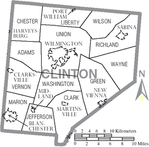
Adjacent counties
- Greene CountyGreene County, OhioGreene County is a county located in the state of Ohio, United States. The population was 161,573 in the 2010 Census. Its county seat is Xenia, and it was named for General Nathanael Greene, an officer in the Revolutionary War. Greene County was established on March 24, 1803.Greene County is part...
(north) - Fayette CountyFayette County, OhioAs of the census of 2000, there were 28,433 people, 11,054 households, and 7,837 families residing in the county. The population density was 70 people per square mile . There were 11,904 housing units at an average density of 29 per square mile...
(northeast) - Highland CountyHighland County, OhioAs of the census of 2000, there were 40,875 people, 15,587 households, and 11,394 families residing in the county. The population density was 74 people per square mile . There were 17,583 housing units at an average density of 32 per square mile...
(southeast) - Brown CountyBrown County, OhioAs of the census of 2000, there were 42,285 people, 15,555 households, and 11,790 families residing in the county. The population density was 86 people per square mile . There were 17,193 housing units at an average density of 35 per square mile...
(south) - Clermont CountyClermont County, OhioClermont County is a county located in the state of Ohio, United States, just east of Cincinnati. As of 2010, the population was 197,363. Its county seat is Batavia...
(southwest) - Warren CountyWarren County, OhioWarren County is a county located in the state of Ohio, United States. The population was 212,693 at the 2010 census. Its county seat is Lebanon. Warren County was erected May 1, 1803, from Hamilton County, and named for Dr...
(west)
Demographics
As of the censusCensus
A census is the procedure of systematically acquiring and recording information about the members of a given population. It is a regularly occurring and official count of a particular population. The term is used mostly in connection with national population and housing censuses; other common...
of 2000, there were 40,543 people, 15,416 households, and 11,068 families residing in the county. The population density
Population density
Population density is a measurement of population per unit area or unit volume. It is frequently applied to living organisms, and particularly to humans...
was 99 people per square mile (38/km²). There were 16,577 housing units at an average density of 40 per square mile (16/km²). The racial makeup of the county was 95.99% White
Race (United States Census)
Race and ethnicity in the United States Census, as defined by the Federal Office of Management and Budget and the United States Census Bureau, are self-identification data items in which residents choose the race or races with which they most closely identify, and indicate whether or not they are...
, 2.19% Black
Race (United States Census)
Race and ethnicity in the United States Census, as defined by the Federal Office of Management and Budget and the United States Census Bureau, are self-identification data items in which residents choose the race or races with which they most closely identify, and indicate whether or not they are...
or African American
Race (United States Census)
Race and ethnicity in the United States Census, as defined by the Federal Office of Management and Budget and the United States Census Bureau, are self-identification data items in which residents choose the race or races with which they most closely identify, and indicate whether or not they are...
, 0.26% Native American
Race (United States Census)
Race and ethnicity in the United States Census, as defined by the Federal Office of Management and Budget and the United States Census Bureau, are self-identification data items in which residents choose the race or races with which they most closely identify, and indicate whether or not they are...
, 0.38% Asian
Race (United States Census)
Race and ethnicity in the United States Census, as defined by the Federal Office of Management and Budget and the United States Census Bureau, are self-identification data items in which residents choose the race or races with which they most closely identify, and indicate whether or not they are...
, 0.20% from other races
Race (United States Census)
Race and ethnicity in the United States Census, as defined by the Federal Office of Management and Budget and the United States Census Bureau, are self-identification data items in which residents choose the race or races with which they most closely identify, and indicate whether or not they are...
, and 0.97% from two or more races. 0.66% of the population were Hispanic
Race (United States Census)
Race and ethnicity in the United States Census, as defined by the Federal Office of Management and Budget and the United States Census Bureau, are self-identification data items in which residents choose the race or races with which they most closely identify, and indicate whether or not they are...
or Latino
Race (United States Census)
Race and ethnicity in the United States Census, as defined by the Federal Office of Management and Budget and the United States Census Bureau, are self-identification data items in which residents choose the race or races with which they most closely identify, and indicate whether or not they are...
of any race. 29.3% were of American
United States
The United States of America is a federal constitutional republic comprising fifty states and a federal district...
, 22.2% German
Germans
The Germans are a Germanic ethnic group native to Central Europe. The English term Germans has referred to the German-speaking population of the Holy Roman Empire since the Late Middle Ages....
, 12.1% English
English people
The English are a nation and ethnic group native to England, who speak English. The English identity is of early mediaeval origin, when they were known in Old English as the Anglecynn. England is now a country of the United Kingdom, and the majority of English people in England are British Citizens...
and 10.9% Irish
Irish people
The Irish people are an ethnic group who originate in Ireland, an island in northwestern Europe. Ireland has been populated for around 9,000 years , with the Irish people's earliest ancestors recorded having legends of being descended from groups such as the Nemedians, Fomorians, Fir Bolg, Tuatha...
ancestry according to Census 2000.
In 2005 94.7% of the county's population was non-Hispanic whites. Latinos were 1.3% of the population.
There were 15,416 households out of which 34.70% had children under the age of 18 living with them, 57.40% were married couples
Marriage
Marriage is a social union or legal contract between people that creates kinship. It is an institution in which interpersonal relationships, usually intimate and sexual, are acknowledged in a variety of ways, depending on the culture or subculture in which it is found...
living together, 10.10% had a female householder with no husband present, and 28.20% were non-families. 23.70% of all households were made up of individuals and 9.90% had someone living alone who was 65 years of age or older. The average household size was 2.56 and the average family size was 3.03.
In the county the population was spread out with 26.40% under the age of 18, 10.20% from 18 to 24, 29.10% from 25 to 44, 22.10% from 45 to 64, and 12.20% who were 65 years of age or older. The median age was 35 years. For every 100 females there were 96.10 males. For every 100 females age 18 and over, there were 92.70 males.
The median income for a household in the county was $40,467, and the median income for a family was $48,158. Males had a median income of $34,448 versus $23,846 for females. The per capita income
Per capita income
Per capita income or income per person is a measure of mean income within an economic aggregate, such as a country or city. It is calculated by taking a measure of all sources of income in the aggregate and dividing it by the total population...
for the county was $18,462. About 6.40% of families and 8.60% of the population were below the poverty line, including 9.90% of those under age 18 and 11.60% of those age 65 or over.
Government
The Wilmington Public Library of Clinton County
Wilmington Public Library of Clinton County, Ohio
The Wilmington Public Library is located at 268 N. South Street in Wilmington, Ohio.-History:In 1899 the George Clinton Chapter of the Daughters of the American Revolution began a subscription library in two rooms of the First National Bank building. They raised $710 and purchased furniture,...
serves the communities of Clinton County from its administrative offices and main library in Wilmington
Wilmington, Ohio
Wilmington is a city in and the county seat of Clinton County, Ohio, United States. The population was 12,520 at the 2010 census. At city entrances from state routes, county roads, and U.S. highways, the city slogan of "We Honor Our Champions" is seen, accompanied by signs that highlight various...
and its Clinton Massie branch in Clarksville
Clarksville, Ohio
Clarksville is a village in Clinton County, Ohio, United States. The population was 497 at the 2000 census. It is served by the Clinton Massie branch of the Wilmington Public Library of Clinton County.-Geography:...
. In 2005, the library loaned more than 161,000 items to its 17,000 cardholders. Total holdings as of 2005 were over 64,000 volumes with over 90 periodical subscriptions.
Communities
Villages
|
Midland, Ohio Midland is a village in Clinton County, Ohio, United States. The population was 265 at the 2000 census.-Geography:Midland is located at .According to the United States Census Bureau, the village has a total area of , all of it land.-Demographics:... New Vienna, Ohio New Vienna is a village in Clinton County, Ohio, United States. The population was 1,294 at the 2000 census.-Geography:New Vienna is located at .... Port William, Ohio Port William is a village in Clinton County, Ohio, United States. The population was 258 at the 2000 census.-Geography:Port William is located at .... Sabina, Ohio Sabina is a village in Clinton County, Ohio, United States. As of the 2000 census, the village had a total population of 2,780.-History:The town of Sabina was laid out by Warren Sabin, after whom it was named, in 1830, on land originally entered by P. Neville. The original plat of the town was... |
Townships
|
Liberty Township, Clinton County, Ohio Liberty Township is one of the thirteen townships of Clinton County, Ohio, United States. The 2000 census found 1,033 people in the township, 775 of whom lived in the unincorporated portions of the township, up from 840 in 1990.-Geography:... Marion Township, Clinton County, Ohio Marion Township is one of the thirteen townships of Clinton County, Ohio, United States. The 2000 census found 5,489 people in the township, 1,269 of whom lived in the unincorporated portions of the township, up from 5,186 in 1990.-Geography:... Richland Township, Clinton County, Ohio Richland Township is one of the thirteen townships of Clinton County, Ohio, United States. The 2000 census found 3,758 people in the township, 978 of whom lived in the unincorporated portions of the township; the population rose from 3,626 in 1990.... Union Township, Clinton County, Ohio Union Township is one of the thirteen townships of Clinton County, Ohio, United States. The 2000 census found 14,929 people in the township, up from 13,379 in 1990; of this total, 3,008 lived in unincorporated portions of the township, up from 2,260 in 1990... |
Vernon Township, Clinton County, Ohio Vernon Township is one of the thirteen townships of Clinton County, Ohio, United States. The 2000 census found 2,685 people in the township, 2,188 of whom lived in the unincorporated portions of the township, up from 2,015 in 1990.-Geography:... Washington Township, Clinton County, Ohio Washington Township is one of the thirteen townships of Clinton County, Ohio, United States. The 2000 census found 1,895 people in the township, up from 1,475 in 1990.-Geography:Located in the southern part of the county, it borders the following townships:... Wayne Township, Clinton County, Ohio Wayne Township is one of the thirteen townships of Clinton County, Ohio, United States. The 2000 census found 737 people in the township, up from 681 in 1990; only Wilson Township has a lower population.-Geography:... Wilson Township, Clinton County, Ohio Wilson Township is one of the thirteen townships of Clinton County, Ohio, United States. The 2000 census found 581 people in the township, up from 523 in 1990.-Geography:Located in the northeastern part of the county, it borders the following townships:... |
Unincorporated communities
|
Reesville, Ohio Reesville is an unincorporated community in northwestern Richland Township, Clinton County, Ohio, United States. Although it is unincorporated, it has a post office, with the ZIP code of 45166. It is located along State Route 72.-References:... |
School districts
The following school districts have territory in Clinton County. Those primarily in Clinton are in bold, those primarily in other counties are in italics. The county a district is primarily located in is bolded.- Blanchester Local School District (also in Brown, Clermont, and Warren)
- Clinton Massie Local School District (also in Warren)
- East Clinton Local (also in Fayette, Greene, and Highland)
- Fairfield Local School District (also in Highland)
- Fayetteville-Perry Local School District (also in Brown)
- Greeneview Local School District (also in Greene)
- Lynchburg-Clay Local School District (also in Highland)
- Miami Trace Local School District (also in Fayette)
- Wilmington City School District (also in Greene)
- Xenia City School District (also in Greene and Warren)
Recreation
Clinton County is home to Cowan Lake State ParkCowan Lake State Park
Cowan Lake State Park is a Ohio state park in Clinton County, Ohio, in the United States. It is operated by the Ohio Department of Natural Resources...
, where outdoor recreationalists enjoy fishing, swimming, boating, hiking, bicycling, camping, and wildlife viewing. The northwestern border of Clinton County is formed by Caesar Creek Lake, which is part of Caesar Creek State Park
Caesar Creek State Park
Caesar Creek State Park is located in southwestern Ohio, five miles east of Waynesville, in Warren, Clinton, and Greene Counties. The park is leased by the State from the U.S. Army Corps of Engineers, who in the 1970s erected a dam on Caesars Creek to impound a lake. The total park area,...
. Fossil hunting is popular here, in addition to similar activities enjoyed at Cowan Lake.
Wilmington College in Wilmington has several NCAA Division III athletic programs, whose events can be attended by the public. The city is also the home of the Clinton County Corn Festival.
In terms of professional sports, Clinton County is firmly within the Cincinnati market. Many residents are supporters of the baseball Cincinnati Reds
Cincinnati Reds
The Cincinnati Reds are a Major League Baseball team based in Cincinnati, Ohio. They are members of the National League Central Division. The club was established in 1882 as a charter member of the American Association and joined the National League in 1890....
and football Cincinnati Bengals
Cincinnati Bengals
The Cincinnati Bengals are a professional football team based in Cincinnati, Ohio. They are members of the AFC's North Division in the National Football League . The Bengals began play in 1968 as an expansion team in the American Football League , and joined the NFL in 1970 in the AFL-NFL...
. Cincinnati is a one hour or less drive away for nearly all Clinton County residents.