
Madison County, Ohio
Encyclopedia
As of the census
of 2000, there were 40,213 people, 13,672 households, and 10,035 families residing in the county. The population density
was 86 people per square mile (33/km²). There were 14,399 housing units at an average density of 31 per square mile (12/km²). The racial makeup of the county was 91.75% White
, 6.24% Black
or African American
, 0.20% Native American
, 0.44% Asian
, 0.01% Pacific Islander
, 0.35% from other races
, and 1.01% from two or more races. 0.73% of the population were Hispanic
or Latino
of any race.
There were 13,672 households out of which 35.20% had children under the age of 18 living with them, 59.20% were married couples
living together, 9.90% had a female householder with no husband present, and 26.60% were non-families. 22.30% of all households were made up of individuals and 9.50% had someone living alone who was 65 years of age or older. The average household size was 2.62 and the average family size was 3.06.
In the county, the population was spread out with 24.70% under the age of 18, 9.10% from 18 to 24, 32.80% from 25 to 44, 22.60% from 45 to 64, and 10.90% who were 65 years of age or older. The median age was 36 years. For every 100 females there were 117.00 males. For every 100 females age 18 and over, there were 121.30 males.
The median income for a household in the county was $44,212, and the median income for a family was $50,520. Males had a median income of $35,251 versus $26,119 for females. The per capita income
for the county was $18,721. About 6.20% of families and 7.80% of the population were below the poverty line, including 10.50% of those under age 18 and 8.70% of those age 65 or over.
Census
A census is the procedure of systematically acquiring and recording information about the members of a given population. It is a regularly occurring and official count of a particular population. The term is used mostly in connection with national population and housing censuses; other common...
of 2000, there were 40,213 people, 13,672 households, and 10,035 families residing in the county. The population density
Population density
Population density is a measurement of population per unit area or unit volume. It is frequently applied to living organisms, and particularly to humans...
was 86 people per square mile (33/km²). There were 14,399 housing units at an average density of 31 per square mile (12/km²). The racial makeup of the county was 91.75% White
Race (United States Census)
Race and ethnicity in the United States Census, as defined by the Federal Office of Management and Budget and the United States Census Bureau, are self-identification data items in which residents choose the race or races with which they most closely identify, and indicate whether or not they are...
, 6.24% Black
Race (United States Census)
Race and ethnicity in the United States Census, as defined by the Federal Office of Management and Budget and the United States Census Bureau, are self-identification data items in which residents choose the race or races with which they most closely identify, and indicate whether or not they are...
or African American
Race (United States Census)
Race and ethnicity in the United States Census, as defined by the Federal Office of Management and Budget and the United States Census Bureau, are self-identification data items in which residents choose the race or races with which they most closely identify, and indicate whether or not they are...
, 0.20% Native American
Race (United States Census)
Race and ethnicity in the United States Census, as defined by the Federal Office of Management and Budget and the United States Census Bureau, are self-identification data items in which residents choose the race or races with which they most closely identify, and indicate whether or not they are...
, 0.44% Asian
Race (United States Census)
Race and ethnicity in the United States Census, as defined by the Federal Office of Management and Budget and the United States Census Bureau, are self-identification data items in which residents choose the race or races with which they most closely identify, and indicate whether or not they are...
, 0.01% Pacific Islander
Race (United States Census)
Race and ethnicity in the United States Census, as defined by the Federal Office of Management and Budget and the United States Census Bureau, are self-identification data items in which residents choose the race or races with which they most closely identify, and indicate whether or not they are...
, 0.35% from other races
Race (United States Census)
Race and ethnicity in the United States Census, as defined by the Federal Office of Management and Budget and the United States Census Bureau, are self-identification data items in which residents choose the race or races with which they most closely identify, and indicate whether or not they are...
, and 1.01% from two or more races. 0.73% of the population were Hispanic
Race (United States Census)
Race and ethnicity in the United States Census, as defined by the Federal Office of Management and Budget and the United States Census Bureau, are self-identification data items in which residents choose the race or races with which they most closely identify, and indicate whether or not they are...
or Latino
Race (United States Census)
Race and ethnicity in the United States Census, as defined by the Federal Office of Management and Budget and the United States Census Bureau, are self-identification data items in which residents choose the race or races with which they most closely identify, and indicate whether or not they are...
of any race.
There were 13,672 households out of which 35.20% had children under the age of 18 living with them, 59.20% were married couples
Marriage
Marriage is a social union or legal contract between people that creates kinship. It is an institution in which interpersonal relationships, usually intimate and sexual, are acknowledged in a variety of ways, depending on the culture or subculture in which it is found...
living together, 9.90% had a female householder with no husband present, and 26.60% were non-families. 22.30% of all households were made up of individuals and 9.50% had someone living alone who was 65 years of age or older. The average household size was 2.62 and the average family size was 3.06.
In the county, the population was spread out with 24.70% under the age of 18, 9.10% from 18 to 24, 32.80% from 25 to 44, 22.60% from 45 to 64, and 10.90% who were 65 years of age or older. The median age was 36 years. For every 100 females there were 117.00 males. For every 100 females age 18 and over, there were 121.30 males.
The median income for a household in the county was $44,212, and the median income for a family was $50,520. Males had a median income of $35,251 versus $26,119 for females. The per capita income
Per capita income
Per capita income or income per person is a measure of mean income within an economic aggregate, such as a country or city. It is calculated by taking a measure of all sources of income in the aggregate and dividing it by the total population...
for the county was $18,721. About 6.20% of families and 7.80% of the population were below the poverty line, including 10.50% of those under age 18 and 8.70% of those age 65 or over.
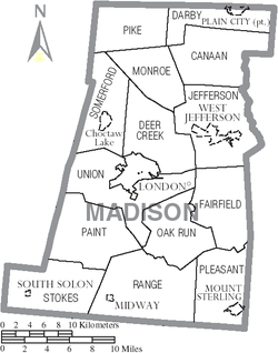
Communities
Villages
|
Plain City, Ohio Plain City is a village on the west banks of Big Darby Creek, in the northern part of Darby Township, Madison County and the southern part of Jerome Township, Union County in the U.S. state of Ohio... South Solon, Ohio South Solon is a village in Madison County, Ohio, United States. The population was 405 at the 2000 census.-Geography:South Solon is located at .... |
West Jefferson, Ohio West Jefferson is a village in Madison County, Ohio, United States. The population was 4,331 at the 2000 census. Located along U.S. Route 40, the village has a fairly close relationship with the surrounding township, which include various out-of-corporation-limit neighborhoods West Jefferson is a... |
Townships
|
Jefferson Township, Madison County, Ohio Jefferson Township is one of the fourteen townships of Madison County, Ohio, United States. The 2000 census found 6,935 people in the township, 2,604 of whom lived in the unincorporated portions of the township.-Geography:... Monroe Township, Madison County, Ohio Monroe Township is one of the fourteen townships of Madison County, Ohio, United States. The 2000 census found 1,769 people in the township.-Geography:Located in the northern part of the county, it borders the following townships:*Pike Township - north... Oak Run Township, Madison County, Ohio Oak Run Township is one of the fourteen townships of Madison County, Ohio, United States. The 2000 census found 514 people in the township.-Geography:Located in the southern part of the county, it borders the following townships:*Fairfield Township - east... Paint Township, Madison County, Ohio Paint Township is one of the fourteen townships of Madison County, Ohio, United States. The 2000 census found 565 people in the township.-Geography:Located in the southwestern part of the county, it borders the following townships:... |
Pike Township, Madison County, Ohio Pike Township is one of the fourteen townships of Madison County, Ohio, United States. The 2000 census found 531 people in the township.-Geography:Located in the northwestern corner of the county, it borders the following townships:... Pleasant Township, Madison County, Ohio Pleasant Township is one of the fourteen townships of Madison County, Ohio, United States. The 2000 census found 3,282 people in the township, 1,417 of whom lived in the unincorporated portions of the township.-Geography:... Range Township, Madison County, Ohio Range Township is one of the fourteen townships of Madison County, Ohio, United States. The 2000 census found 983 people in the township, 709 of whom lived in the unincorporated portions of the township.-Geography:... |
Somerford Township, Madison County, Ohio Somerford Township is one of the fourteen townships of Madison County, Ohio, United States. The 2000 census found 6,975 people in the township.-Geography:Located in the western part of the county, it borders the following townships:*Pike Township - north... Stokes Township, Madison County, Ohio Stokes Township is one of the fourteen townships of Madison County, Ohio, United States. The 2000 census found 746 people in the township, 341 of whom lived in the unincorporated portions of the township.-Geography:... Union Township, Madison County, Ohio Union Township is one of the fourteen townships of Madison County, Ohio, United States. The 2000 census found 1,411 people in the township.-Geography:Located in the western part of the county, it borders the following townships:*Deer Creek Township - north... |
Other communities
|
Gillivan, Ohio Gillivan is an unincorporated community in Jefferson Township, Madison County, Ohio, United States. It is located at , along U.S. Route 42, north of its intersection with Ohio State Route 29.... Kileville, Ohio Kileville is an unincorporated community in Darby Township, Madison County, Ohio, United States. It is located at , along Ohio State Route 161, between Plain City and Dublin.... Kiousville, Ohio Kiousville is an unincorporated community in southern Fairfield Township, Madison County, Ohio, United States. It is located at , at the intersection of Kiousville-Georgesville Road and McKendree Road.... Lafayette, Madison County, Ohio Lafayette is a census-designated place in the center of Deer Creek Township, Madison County, Ohio, United States. It is located at , along U.S. Route 40, just west of its intersection with U.S. Route 42.-Lawrenceville:... Lilly Chapel, Ohio Lilly Chapel is an unincorporated community in Fairfield Township, Madison County, Ohio, United States. It is located at , at the intersection of W. Jefferson Kiousville Road and Lilly Chapel Georgesville Road, approx... |
McClimansville, Ohio McClimansville is an unincorporated community in Pleasant Township, Madison County, Ohio, United States. It is located at , at the intersection of Ohio State Route 323 and Ohio State Route 56, just north of Mount Sterling.... Newport, Madison County, Ohio Newport is an unincorporated community in Paint Township, Madison County, Ohio, United States. It is located at , along Ohio State Route 38 between London and Midway.-History:... Plumwood, Ohio Plumwood is a census-designated place in central Monroe Township, Madison County, Ohio, United States. It lies at the intersection of State Route 38 with Arthur Bradley Road, 8½ miles north of the city of London, the county seat of Madison County... Range, Ohio Range is an unincorporated community in Range Township, Madison County, Ohio, United States. It is located at , along Ohio State Route 323 between Chenoweth and Midway.... Resaca, Ohio Resaca is an unincorporated community in Monroe Township, Madison County, Ohio, United States. It is located at , at the intersection of Finley Guy Road and Woods and W Avenue.... |
Rosedale, Ohio Rosedale is an unincorporated community in central Pike Township, Madison County, Ohio, United States, and roughly thirty miles west of the city of Columbus. The ZIP code is 43029 and mail is currently delivered by the Irwin post office.... Rupert, Ohio Rupert is an unincorporated community in Union Township, Madison County, Ohio, United States. It is located at , at the intersection of Ohio State Route 665 and Glade Run Road, approx. 4 miles east of London.... Summerford, Ohio Summerford is an unincorporated community in Somerford Township, Madison County, Ohio, United States. It is located at , at the intersection of U.S. Route 40 and State Route 56.-History:... Tradersville, Ohio Tradersville is an unincorporated community in Somerford Township, Madison County, Ohio, United States. It is located at , at the intersection of Ohio State Route 187 and Tradersville-Brighton Road, about 3 miles north of Choctaw Lake.... Wrightsville, Ohio Wrightsville is an unincorporated community in Fairfield Township, Madison County, Ohio, United States. It is located at , at the intersection of Ohio State Route 665 and Georgesville-Wrightsville Road, approx. 4 miles north of Kiousville... |
Libraries in Madison County
The following libraries serve the communities of Madison County.- Hurt/Battelle Memorial Library in West Jefferson, OhioWest Jefferson, OhioWest Jefferson is a village in Madison County, Ohio, United States. The population was 4,331 at the 2000 census. Located along U.S. Route 40, the village has a fairly close relationship with the surrounding township, which include various out-of-corporation-limit neighborhoods West Jefferson is a...
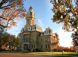
- London Public Library (Ohio) in London, OhioLondon, OhioLondon is a city in and the county seat of Madison County, Ohio, United States. Located about southwest of the Ohio capital of Columbus, London was established in 1811 to serve as the county seat. As of the 2000 census, the city population was 8,771, an increase from 7,807 in 1990. It is the...
- Mount Sterling Public Library in Mt. Sterling, OhioMount Sterling, OhioMount Sterling is a village in Madison County, Ohio, United States. The population was 1,865 at the 2000 census. It is a part of the Columbus, Ohio Metropolitan Statistical Area....
- Plain City Public Library in Plain City, OhioPlain City, OhioPlain City is a village on the west banks of Big Darby Creek, in the northern part of Darby Township, Madison County and the southern part of Jerome Township, Union County in the U.S. state of Ohio...