
Clark County, Ohio
Encyclopedia
As of the census
of 2000, there were 144,742 people, 56,648 households, and 39,370 families residing in the county. The population density
was 362 people per square mile (140/km²). There were 61,056 housing units at an average density of 153 per square mile (59/km²). The racial makeup of the county was 88.12% White
, 8.95% Black
or African American
, 0.28% Native American
, 0.53% Asian
, 0.02% Pacific Islander
, 0.53% from other races
, and 1.58% from two or more races. 1.17% of the population were Hispanic
or Latino
of any race. 23.8% were of German
, 21.6% American
, 10.4% Irish
and 8.7% English
ancestry according to Census 2000.
 There were 56,648 households out of which 31.40% had children under the age of 18 living with them, 52.60% were married couples
living together, 12.80% had a female householder with no husband present, and 30.50% were non-families. 26.00% of all households were made up of individuals and 11.10% had someone living alone who was 65 years of age or older. The average household size was 2.49 and the average family size was 2.97.
In the county the population was spread out with 25.10% under the age of 18, 9.10% from 18 to 24, 26.80% from 25 to 44, 24.30% from 45 to 64, and 14.70% who were 65 years of age or older. The median age was 38 years. For every 100 females there were 92.50 males. For every 100 females age 18 and over, there were 88.60 males.
The median income for a household in the county was $40,340, and the median income for a family was $48,259. Males had a median income of $37,157 versus $24,688 for females. The per capita income
for the county was $19,501. About 7.90% of families and 10.70% of the population were below the poverty line, including 14.90% of those under age 18 and 8.20% of those age 65 or over.
of 1960
, the population had grown to 131,440, a 18 percent increase over the previous census. Champaign County
was added to the Springfield SMSA in 1973. The two-county area had a combined population of 187,606 in 1970.
In 1983, the official name was shortened to the Springfield Metropolitan Statistical Area (Springfield MSA). That same year, Dayton and Springfield were grouped together as the Dayton-Springfield Metropolitan Statistical Area. The new MSA consisted of four counties – Clark, Greene
, Miami
, and Montgomery
. This arrangement remained unchanged until 2003, when the MSA was split with Springfield's newly defined metropolitan area including only Clark County.
Census
A census is the procedure of systematically acquiring and recording information about the members of a given population. It is a regularly occurring and official count of a particular population. The term is used mostly in connection with national population and housing censuses; other common...
of 2000, there were 144,742 people, 56,648 households, and 39,370 families residing in the county. The population density
Population density
Population density is a measurement of population per unit area or unit volume. It is frequently applied to living organisms, and particularly to humans...
was 362 people per square mile (140/km²). There were 61,056 housing units at an average density of 153 per square mile (59/km²). The racial makeup of the county was 88.12% White
Race (United States Census)
Race and ethnicity in the United States Census, as defined by the Federal Office of Management and Budget and the United States Census Bureau, are self-identification data items in which residents choose the race or races with which they most closely identify, and indicate whether or not they are...
, 8.95% Black
Race (United States Census)
Race and ethnicity in the United States Census, as defined by the Federal Office of Management and Budget and the United States Census Bureau, are self-identification data items in which residents choose the race or races with which they most closely identify, and indicate whether or not they are...
or African American
Race (United States Census)
Race and ethnicity in the United States Census, as defined by the Federal Office of Management and Budget and the United States Census Bureau, are self-identification data items in which residents choose the race or races with which they most closely identify, and indicate whether or not they are...
, 0.28% Native American
Race (United States Census)
Race and ethnicity in the United States Census, as defined by the Federal Office of Management and Budget and the United States Census Bureau, are self-identification data items in which residents choose the race or races with which they most closely identify, and indicate whether or not they are...
, 0.53% Asian
Race (United States Census)
Race and ethnicity in the United States Census, as defined by the Federal Office of Management and Budget and the United States Census Bureau, are self-identification data items in which residents choose the race or races with which they most closely identify, and indicate whether or not they are...
, 0.02% Pacific Islander
Race (United States Census)
Race and ethnicity in the United States Census, as defined by the Federal Office of Management and Budget and the United States Census Bureau, are self-identification data items in which residents choose the race or races with which they most closely identify, and indicate whether or not they are...
, 0.53% from other races
Race (United States Census)
Race and ethnicity in the United States Census, as defined by the Federal Office of Management and Budget and the United States Census Bureau, are self-identification data items in which residents choose the race or races with which they most closely identify, and indicate whether or not they are...
, and 1.58% from two or more races. 1.17% of the population were Hispanic
Race (United States Census)
Race and ethnicity in the United States Census, as defined by the Federal Office of Management and Budget and the United States Census Bureau, are self-identification data items in which residents choose the race or races with which they most closely identify, and indicate whether or not they are...
or Latino
Race (United States Census)
Race and ethnicity in the United States Census, as defined by the Federal Office of Management and Budget and the United States Census Bureau, are self-identification data items in which residents choose the race or races with which they most closely identify, and indicate whether or not they are...
of any race. 23.8% were of German
Germans
The Germans are a Germanic ethnic group native to Central Europe. The English term Germans has referred to the German-speaking population of the Holy Roman Empire since the Late Middle Ages....
, 21.6% American
United States
The United States of America is a federal constitutional republic comprising fifty states and a federal district...
, 10.4% Irish
Irish people
The Irish people are an ethnic group who originate in Ireland, an island in northwestern Europe. Ireland has been populated for around 9,000 years , with the Irish people's earliest ancestors recorded having legends of being descended from groups such as the Nemedians, Fomorians, Fir Bolg, Tuatha...
and 8.7% English
English people
The English are a nation and ethnic group native to England, who speak English. The English identity is of early mediaeval origin, when they were known in Old English as the Anglecynn. England is now a country of the United Kingdom, and the majority of English people in England are British Citizens...
ancestry according to Census 2000.
Marriage
Marriage is a social union or legal contract between people that creates kinship. It is an institution in which interpersonal relationships, usually intimate and sexual, are acknowledged in a variety of ways, depending on the culture or subculture in which it is found...
living together, 12.80% had a female householder with no husband present, and 30.50% were non-families. 26.00% of all households were made up of individuals and 11.10% had someone living alone who was 65 years of age or older. The average household size was 2.49 and the average family size was 2.97.
In the county the population was spread out with 25.10% under the age of 18, 9.10% from 18 to 24, 26.80% from 25 to 44, 24.30% from 45 to 64, and 14.70% who were 65 years of age or older. The median age was 38 years. For every 100 females there were 92.50 males. For every 100 females age 18 and over, there were 88.60 males.
The median income for a household in the county was $40,340, and the median income for a family was $48,259. Males had a median income of $37,157 versus $24,688 for females. The per capita income
Per capita income
Per capita income or income per person is a measure of mean income within an economic aggregate, such as a country or city. It is calculated by taking a measure of all sources of income in the aggregate and dividing it by the total population...
for the county was $19,501. About 7.90% of families and 10.70% of the population were below the poverty line, including 14.90% of those under age 18 and 8.20% of those age 65 or over.
Springfield MSA
Clark County is coterminous with the Springfield, Ohio Metropolitan Statistical Area.History
The Springfield metropolitan area was first defined in 1950. Then known as the Springfield Standard Metropolitan Area (Springfield SMA), it consisted of a single county – Clark – and had a population of 111,661. Following a term change by the Bureau of the Budget (present-day Office of Management and Budget) in 1959, the Springfield SMA became the Springfield Standard Metropolitan Statistical Area (Springfield SMSA). By the censusUnited States Census
The United States Census is a decennial census mandated by the United States Constitution. The population is enumerated every 10 years and the results are used to allocate Congressional seats , electoral votes, and government program funding. The United States Census Bureau The United States Census...
of 1960
United States Census, 1960
The Eighteenth United States Census, conducted by the Census Bureau, determined the resident population of the United States to be 179,323,175, an increase of 18.5 percent over the 151,325,798 persons enumerated during the 1950 Census.-Census questions:...
, the population had grown to 131,440, a 18 percent increase over the previous census. Champaign County
Champaign County, Ohio
As of the census of 2000, there were 38,890 people, 14,952 households, and 10,870 families residing in the county. The population density was 91 people per square mile . There were 15,890 housing units at an average density of 37 per square mile...
was added to the Springfield SMSA in 1973. The two-county area had a combined population of 187,606 in 1970.
In 1983, the official name was shortened to the Springfield Metropolitan Statistical Area (Springfield MSA). That same year, Dayton and Springfield were grouped together as the Dayton-Springfield Metropolitan Statistical Area. The new MSA consisted of four counties – Clark, Greene
Greene County, Ohio
Greene County is a county located in the state of Ohio, United States. The population was 161,573 in the 2010 Census. Its county seat is Xenia, and it was named for General Nathanael Greene, an officer in the Revolutionary War. Greene County was established on March 24, 1803.Greene County is part...
, Miami
Miami County, Ohio
As of the census of 2000, there were 98,868 people, 38,437 households, and 27,943 families residing in the county. The population density was 243 people per square mile . There were 40,554 housing units at an average density of 100 per square mile...
, and Montgomery
Montgomery County, Ohio
Montgomery County is a county located in the state of Ohio, United States. The population was 535,153 in the 2010 Census. It was named in honor of Richard Montgomery, an American Revolutionary War general killed in 1775 while attempting to capture Quebec City, Canada. The county seat is Dayton...
. This arrangement remained unchanged until 2003, when the MSA was split with Springfield's newly defined metropolitan area including only Clark County.
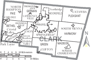
Communities
Villages
|
North Hampton, Ohio North Hampton is a village in Clark County, Ohio, United States. The population was 370 at the 2000 census. It is part of the Springfield, Ohio Metropolitan Statistical Area.-Geography:North Hampton is located at .... South Charleston, Ohio South Charleston is a village in Clark County, Ohio, United States. The population was 1,850 at the 2000 census. It is part of the Springfield, Ohio Metropolitan Statistical Area.-Geography:South Charleston is located at .... South Vienna, Ohio South Vienna is a village in Clark County, Ohio, United States. The population was 469 at the 2000 census. It is part of the Springfield, Ohio Metropolitan Statistical Area.... Tremont City, Ohio Tremont City is a village in Clark County, Ohio, United States. The population was 349 at the 2000 census. The village is part of the Springfield, Ohio Metropolitan Statistical Area.-Geography:Tremont City is located at .... |
Townships
|
Madison Township, Clark County, Ohio Madison Township is one of the ten townships of Clark County, Ohio, United States. The 2000 census found 2,796 people in the township, 946 of whom lived in the unincorporated portions of the township.-Geography:... Moorefield Township, Clark County, Ohio Moorefield Township is one of the ten townships of Clark County, Ohio, United States. The 2000 census found 11,402 people in the township.-Geography:Located in the northern part of the county, it borders the following townships:... Pike Township, Clark County, Ohio Pike Township is one of the ten townships of Clark County, Ohio, United States. The 2000 census found 3,891 people in the township, 3,521 of whom lived in the unincorporated portions of the township.-Geography:... Pleasant Township, Clark County, Ohio Pleasant Township is one of the ten townships of Clark County, Ohio, United States. The 2000 census found 3,134 people in the township, 2,822 of whom lived in the unincorporated portions of the township.-Geography:... Springfield Township, Clark County, Ohio Springfield Township is one of the ten townships of Clark County, Ohio, United States. The 2000 census found 13,424 people in the township.-Geography:Located at the center of the county, it borders the following townships:*Moorefield Township - north... |
Census-designated places
|
Northridge, Clark County, Ohio Northridge is a census-designated place in Clark County, Ohio, United States. The population was 6,853 at the 2000 census. It is part of the Springfield, Ohio Metropolitan Statistical Area.-Geography:Northridge is located at .... Park Layne, Ohio Park Layne is a census-designated place in Clark County, Ohio, United States. The population was 4,519 at the 2000 census. It is part of the Springfield, Ohio Metropolitan Statistical Area.-Geography:Park Layne is located at .... |
Other communities
- LawrencevilleLawrenceville, OhioLawrenceville is an unincorporated community in central German Township, Clark County, Ohio, United States. It is part of the Springfield, Ohio Metropolitan Statistical Area. The population was 302 at the 2000 census, at which time it was a village...
- MedwayMedway, OhioMedway is an unincorporated community in Bethel Township, Clark County, Ohio, United States. It is part of the Springfield, Ohio Metropolitan Statistical Area. Near are the adjoining communities of Crystal Lakes and Park Layne. The population of its ZCTA for ZIP Code 45341, which includes Medway,...
- PlattsburghPlattsburgh, OhioPlattsburgh is an unincorporated village in central Harmony Township, Clark County, Ohio, United States. It is located along State Route 54 near the headwaters of the North Fork Little Miami River....
Public School Districts
- Clark - Shawnee Local School District
- Shawnee High School, Springfield (the Braves)
- Greenon Local School District
- Greenon High SchoolGreenon High SchoolGreenon High School is a public high school in Springfield, Ohio. It is the only high school in the Greenon Local School District. Attendance rate during the 2008 school year was 94.3% compared to the state average of 94.1%. Graduation rate was 93.2% compared to the state average of 86.1%....
, Springfield (the Knights)
- Greenon High School
- Northeastern Local School District
- Kenton Ridge High School, Springfield (the Cougars)
- Northeastern High School , Springfield (the Jets)
- Northwestern Local School District
- Northwestern High School, Springfield (the Warriors)
- Southeastern Local Schools
- Southeastern High School, South Charleston (the Trojans)
- Springfield City School District
- Springfield City High School, (the Wildcats)]
- Tecumseh Local School DistrictTecumseh Local School DistrictThe Tecumseh Local School District is a school district in western Clark County, Ohio which serves the city of New Carlisle, the towns of Medway and Donnelsville, and the surrounding unincorporated areas...
- Tecumseh High SchoolTecumseh High School (New Carlisle, Ohio)Tecumseh High School is a public high school near New Carlisle, Ohio. The school and district are named in honor of Tecumseh, the Shawnee Indian chief and warrior who lived in the general area between approximately 1768 and 1813.-Area served:...
, New Carlisle (the Arrows)
- Tecumseh High School
See also
- Clark County Public LibraryClark County Public LibraryClark County Public Library is the public library of Clark County, Ohio, United States. It is based in Springfield, Ohio and has a collection of approximately 500,000 items.-History:...
- Clark County Heritage CenterClark County Heritage CenterThe Clark County Heritage Center is a building in central Springfield, Ohio, United States. Originally built for the city's offices in 1890, it is now the location of the Clark County Historical Society , which includes a museum, research library and archives. The building has been listed on the...
- National Register of Historic Places listings in Clark County, Ohio