
Montgomery County, Ohio
Encyclopedia
Montgomery County is a county located in the state
of Ohio
, United States
. The population was 535,153 in the 2010 Census. It was named in honor of Richard Montgomery
, an American Revolutionary War
general killed in 1775 while attempting to capture Quebec City
, Canada
. The county seat
is Dayton
. Montgomery County is the fifth most populous county in Ohio.
The county is part of the Dayton Metropolitan Statistical Area.
, the county has a total area of 464 square miles (1,201.8 km²).462 square miles (1,196 km²) of it is land and 3 square miles (7.8 km²) of it (0.58%) is water.
of 2000, there were 559,062 people, 229,229 households, and 146,935 families residing in the county. The population density
was 1,211 people per square mile (468/km²). There were 248,443 housing units at an average density of 538 per square mile (208/km²). The racial makeup of the county was 76.57% White
, 19.86% Black
or African American
, 0.23% Native American
, 1.31% Asian
, 0.04% Pacific Islander
, 0.49% from other races
, and 1.51% from two or more races. 1.27% of the population were Hispanic
or Latino
of any race.
There were 229,229 households out of which 29.60% had children under the age of 18 living with them, 46.30% were married couples
living together, 13.80% had a female householder with no husband present, and 35.90% were non-families. 30.40% of all households were made up of individuals and 10.10% had someone living alone who was 65 years of age or older. The average household size was 2.37 and the average family size was 2.96.
In the county, the population was spread out with 24.70% under the age of 18, 9.70% from 18 to 24, 29.00% from 25 to 44, 22.90% from 45 to 64, and 13.70% who were 65 years of age or older. The median age was 36 years. For every 100 females there were 92.30 males. For every 100 females age 18 and over, there were 88.60 males.
The median income for a household in the county was $40,156, and the median income for a family was $50,071. Males had a median income of $38,710 versus $27,297 for females. The per capita income
for the county was $21,743. About 8.30% of families and 11.30% of the population were below the poverty line, including 15.60% of those under age 18 and 8.20% of those age 65 or over.

See also:

----
U.S. state
A U.S. state is any one of the 50 federated states of the United States of America that share sovereignty with the federal government. Because of this shared sovereignty, an American is a citizen both of the federal entity and of his or her state of domicile. Four states use the official title of...
of Ohio
Ohio
Ohio is a Midwestern state in the United States. The 34th largest state by area in the U.S.,it is the 7th‑most populous with over 11.5 million residents, containing several major American cities and seven metropolitan areas with populations of 500,000 or more.The state's capital is Columbus...
, United States
United States
The United States of America is a federal constitutional republic comprising fifty states and a federal district...
. The population was 535,153 in the 2010 Census. It was named in honor of Richard Montgomery
Richard Montgomery
Richard Montgomery was an Irish-born soldier who first served in the British Army. He later became a brigadier-general in the Continental Army during the American Revolutionary War and he is most famous for leading the failed 1775 invasion of Canada.Montgomery was born and raised in Ireland...
, an American Revolutionary War
American Revolutionary War
The American Revolutionary War , the American War of Independence, or simply the Revolutionary War, began as a war between the Kingdom of Great Britain and thirteen British colonies in North America, and ended in a global war between several European great powers.The war was the result of the...
general killed in 1775 while attempting to capture Quebec City
Quebec City
Quebec , also Québec, Quebec City or Québec City is the capital of the Canadian province of Quebec and is located within the Capitale-Nationale region. It is the second most populous city in Quebec after Montreal, which is about to the southwest...
, Canada
Canada
Canada is a North American country consisting of ten provinces and three territories. Located in the northern part of the continent, it extends from the Atlantic Ocean in the east to the Pacific Ocean in the west, and northward into the Arctic Ocean...
. The county seat
County seat
A county seat is an administrative center, or seat of government, for a county or civil parish. The term is primarily used in the United States....
is Dayton
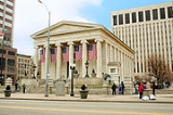
Dayton, Ohio
Dayton is the 6th largest city in the U.S. state of Ohio and the county seat of Montgomery County, the fifth most populous county in the state. The population was 141,527 at the 2010 census. The Dayton Metropolitan Statistical Area had a population of 841,502 in the 2010 census...
. Montgomery County is the fifth most populous county in Ohio.
The county is part of the Dayton Metropolitan Statistical Area.
Geography
According to the U.S. Census BureauUnited States Census Bureau
The United States Census Bureau is the government agency that is responsible for the United States Census. It also gathers other national demographic and economic data...
, the county has a total area of 464 square miles (1,201.8 km²).462 square miles (1,196 km²) of it is land and 3 square miles (7.8 km²) of it (0.58%) is water.
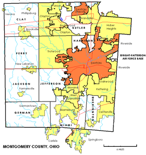
Adjacent counties
- Miami CountyMiami County, OhioAs of the census of 2000, there were 98,868 people, 38,437 households, and 27,943 families residing in the county. The population density was 243 people per square mile . There were 40,554 housing units at an average density of 100 per square mile...
(north) - Clark CountyClark County, OhioAs of the census of 2000, there were 144,742 people, 56,648 households, and 39,370 families residing in the county. The population density was 362 people per square mile . There were 61,056 housing units at an average density of 153 per square mile...
(northeast) - Greene CountyGreene County, OhioGreene County is a county located in the state of Ohio, United States. The population was 161,573 in the 2010 Census. Its county seat is Xenia, and it was named for General Nathanael Greene, an officer in the Revolutionary War. Greene County was established on March 24, 1803.Greene County is part...
(east) - Warren CountyWarren County, OhioWarren County is a county located in the state of Ohio, United States. The population was 212,693 at the 2010 census. Its county seat is Lebanon. Warren County was erected May 1, 1803, from Hamilton County, and named for Dr...
(south) - Butler CountyButler County, OhioButler County is a county located in the state of Ohio, United States. As of 2010, the population was 368,130. Its county seat is Hamilton. It is named for General Richard Butler, who died in 1791 fighting Indians in northern Ohio. Butler's army marched out of Fort Hamilton, where the city of...
(southwest) - Preble CountyPreble County, OhioAs of the census of 2000, there were 42,337 people, 16,001 households, and 12,144 families residing in the county. The population density was 100 people per square mile . There were 17,186 housing units at an average density of 40 per square mile...
(west) - Darke CountyDarke County, OhioAs of the census of 2000, there were 53,309 people, 20,419 households, and 14,905 families residing in the county. The population density was 89 people per square mile . There were 21,583 housing units at an average density of 36 per square mile...
(northwest)
Major highways
 Interstate 70Interstate 70Interstate 70 is an Interstate Highway in the United States that runs from Interstate 15 near Cove Fort, Utah, to a Park and Ride near Baltimore, Maryland. It was the first Interstate Highway project in the United States. I-70 approximately traces the path of U.S. Route 40 east of the Rocky...
(major east and west highway that serves suburbs of Dayton) Interstate 75Interstate 75Interstate 75 is a major north–south Interstate Highway in the Great Lakes and Southeastern regions of the United States. It travels from State Road 826 and State Road 924 in Hialeah, Florida to Sault Ste. Marie, Michigan, at the Ontario, Canada, border...
(major north and south highway that goes through Dayton) Interstate 675Interstate 675 (Ohio)Interstate 675 is an auxiliary interstate highway in the suburbs of Dayton in the U.S. state of Ohio. Interstate 675 serves as an eastern bypass of Dayton. I-675 measures in length...
(a bypass routh that serves southern Montgomery County) U.S. Highway 25 (which was eliminated when Interstate 75 was created in its place here)
 U.S. Highway 35
 U.S. Highway 40
 State Route 4
 State Route 48Ohio State Route 48State Route 48 is a north–south highway in Ohio that runs from SR 132 near Goshen to SR 66 near Houston, passing through Dayton.In the early 20th century, SR 48 was assigned to completely unrelated routes within the state...
 State Route 49Ohio State Route 49State Route 49 or SR 49 is a state highway in the western part of the U.S. state of Ohio. It begins at Drexel with US 35 and runs northwesterly to Greenville, and then runs roughly along near the western edge of the state near the Indiana state line to the Michigan state line where it meets with...
 State Route 123Ohio State Route 123In Ohio, State Route 123 is a state highway which runs Ohio Route 251 about southeast of Blanchester to Germantown, a distance of .-External links:*...
 State Route 201Ohio State Route 201State Route 201 is a long north–south state highway in the western portion of the U.S. state of Ohio. The southern terminus of SR 201 is at an interchange with the SR 4 freeway in Dayton...
 State Route 202Ohio State Route 202State Route 202 is a north–south state highway in the western part of the U.S. state of Ohio. The highway runs from its southern terminus at an interchange with the SR 4 freeway in Dayton to its northern terminus at a T-intersection with SR 55 in the eastern end of Troy.The...
 State Route 235
 State Route 444
 State Route 725
 State Route 741Ohio State Route 741State Route 741 is a north–south state highway in the southwest portion of the U.S. state of Ohio. The southern terminus of the route is at a diamond interchange with I-71 at its Exit 25 near Kings Mills, adjacent to the Kings Island Amusement Park...
 State Route 835
Demographics
As of the censusCensus
A census is the procedure of systematically acquiring and recording information about the members of a given population. It is a regularly occurring and official count of a particular population. The term is used mostly in connection with national population and housing censuses; other common...
of 2000, there were 559,062 people, 229,229 households, and 146,935 families residing in the county. The population density
Population density
Population density is a measurement of population per unit area or unit volume. It is frequently applied to living organisms, and particularly to humans...
was 1,211 people per square mile (468/km²). There were 248,443 housing units at an average density of 538 per square mile (208/km²). The racial makeup of the county was 76.57% White
Race (United States Census)
Race and ethnicity in the United States Census, as defined by the Federal Office of Management and Budget and the United States Census Bureau, are self-identification data items in which residents choose the race or races with which they most closely identify, and indicate whether or not they are...
, 19.86% Black
Race (United States Census)
Race and ethnicity in the United States Census, as defined by the Federal Office of Management and Budget and the United States Census Bureau, are self-identification data items in which residents choose the race or races with which they most closely identify, and indicate whether or not they are...
or African American
Race (United States Census)
Race and ethnicity in the United States Census, as defined by the Federal Office of Management and Budget and the United States Census Bureau, are self-identification data items in which residents choose the race or races with which they most closely identify, and indicate whether or not they are...
, 0.23% Native American
Race (United States Census)
Race and ethnicity in the United States Census, as defined by the Federal Office of Management and Budget and the United States Census Bureau, are self-identification data items in which residents choose the race or races with which they most closely identify, and indicate whether or not they are...
, 1.31% Asian
Race (United States Census)
Race and ethnicity in the United States Census, as defined by the Federal Office of Management and Budget and the United States Census Bureau, are self-identification data items in which residents choose the race or races with which they most closely identify, and indicate whether or not they are...
, 0.04% Pacific Islander
Race (United States Census)
Race and ethnicity in the United States Census, as defined by the Federal Office of Management and Budget and the United States Census Bureau, are self-identification data items in which residents choose the race or races with which they most closely identify, and indicate whether or not they are...
, 0.49% from other races
Race (United States Census)
Race and ethnicity in the United States Census, as defined by the Federal Office of Management and Budget and the United States Census Bureau, are self-identification data items in which residents choose the race or races with which they most closely identify, and indicate whether or not they are...
, and 1.51% from two or more races. 1.27% of the population were Hispanic
Race (United States Census)
Race and ethnicity in the United States Census, as defined by the Federal Office of Management and Budget and the United States Census Bureau, are self-identification data items in which residents choose the race or races with which they most closely identify, and indicate whether or not they are...
or Latino
Race (United States Census)
Race and ethnicity in the United States Census, as defined by the Federal Office of Management and Budget and the United States Census Bureau, are self-identification data items in which residents choose the race or races with which they most closely identify, and indicate whether or not they are...
of any race.
There were 229,229 households out of which 29.60% had children under the age of 18 living with them, 46.30% were married couples
Marriage
Marriage is a social union or legal contract between people that creates kinship. It is an institution in which interpersonal relationships, usually intimate and sexual, are acknowledged in a variety of ways, depending on the culture or subculture in which it is found...
living together, 13.80% had a female householder with no husband present, and 35.90% were non-families. 30.40% of all households were made up of individuals and 10.10% had someone living alone who was 65 years of age or older. The average household size was 2.37 and the average family size was 2.96.
In the county, the population was spread out with 24.70% under the age of 18, 9.70% from 18 to 24, 29.00% from 25 to 44, 22.90% from 45 to 64, and 13.70% who were 65 years of age or older. The median age was 36 years. For every 100 females there were 92.30 males. For every 100 females age 18 and over, there were 88.60 males.
The median income for a household in the county was $40,156, and the median income for a family was $50,071. Males had a median income of $38,710 versus $27,297 for females. The per capita income
Per capita income
Per capita income or income per person is a measure of mean income within an economic aggregate, such as a country or city. It is calculated by taking a measure of all sources of income in the aggregate and dividing it by the total population...
for the county was $21,743. About 8.30% of families and 11.30% of the population were below the poverty line, including 15.60% of those under age 18 and 8.20% of those age 65 or over.
Government
Current officials
- Board of Commissioners:
- Dan FoleyDan FoleyDan Foley is the County Commissioner of Montgomery County, Ohio. He was previously the Clerk of Courts. Elected to his current role in the 2006 election, he took office in January 2007.Foley is a member of the Democratic Party.-Biography:...
(D) - Debbie Lieberman (D)
- Judy DodgeJudy DodgeJudy Dodge is an American politician of the Democratic Party.As of January 14, 2008, Dodge was elected as President of the Montgomery County, Ohio Commission....
(D)
- Dan Foley
- County Auditor: Karl L. Keith (D)
- Clerk of Courts: Gregory A. Brush (D)
- County Coroner: James H. Davis (R)
- County Engineer: Joseph Litvin (D)
- County Prosecutor: Mathias H. Heck Jr. (D)
- County Recorder: Willis Blackshear (D)
- Sheriff: Phil Plummer (R)
- County Treasurer: Carolyn Rice (D)
See also:
- Election Results, Montgomery County, OhioElection Results, Montgomery County, Ohio-County Board of Commissioners:Montgomery County, Ohio, is governed by a three-member county commission. As of January 2007, the board comprises three Democratic members: Debbie Lieberman, Judy Dodge, and Dan Foley.-Term Commencing Jan. 2, 2001, 2005, etc.:...
Politics
In the last five presidential elections Montgomery County has favored the Democratic candidate, but not by large margins.| Year | Democrat Democratic Party (United States) The Democratic Party is one of two major contemporary political parties in the United States, along with the Republican Party. The party's socially liberal and progressive platform is largely considered center-left in the U.S. political spectrum. The party has the lengthiest record of continuous... |
Republican Republican Party (United States) The Republican Party is one of the two major contemporary political parties in the United States, along with the Democratic Party. Founded by anti-slavery expansion activists in 1854, it is often called the GOP . The party's platform generally reflects American conservatism in the U.S... |
|---|---|---|
| 2008 | 52.3% 145,997 | 46.1% 128,679 |
| 2004 | 50.6% 142,997 | 49.0% 138,371 |
| 2000 | 49.6% 114,597 | 47.5% 109,792 |
| 1996 | 50.0% 115,469 | 41.3% 95,391 |
| 1992 | 41.3% 108,017 | 40.0% 104,751 |
| 1988 | 41.8% 95,737 | 57.5% 131,569 |
| 1984 | 40.5% 94,016 | 59.0% 137,053 |
| 1980 | 50.0% 105,110 | 47.1% 101,443 |
| 1976 | 50.4% 106,468 | 47.4% 100,223 |
| 1972 | 39.4% 82,231 | 58.0% 120,998 |
| 1968 | 46.4% 96,082 | 40.9% 84,766 |
| 1964 | 63.8% 126,633 | 36.2% 71,979 |
| 1960 | 47.3% 98,325 | 52.7% 109,602 |
Communities
Cities
|
Huber Heights, Ohio Huber Heights is a city in Montgomery, Miami, and Greene Counties in the U.S. state of Ohio. Huber Heights's motto is "America's largest community of brick homes." The city is named for Charles Huber, the developer who constructed a number of the houses that would later comprise the city. Suburban... Kettering, Ohio As of the census of 2000, there were 57,502 people, 25,657 households, and 15,727 families residing in the city. The population density was 3,077.4 people per square mile . There were 26,936 housing units at an average density of 1,441.6 per square mile... Miamisburg, Ohio Miamisburg is a city in Montgomery County, Ohio, United States. The population was 20,181 at the 2010 census. It is part of the Dayton Metropolitan Statistical Area... Moraine, Ohio Moraine is a city in Montgomery County, Ohio, United States. The population was 6,307 at the 2010 census. The city is part of the The Dayton Metropolitan Statistical Area, which includes Montgomery county. Moraine, as part of the Dayton area, is situated within the Miami Valley region of Ohio, just... Oakwood, Montgomery County, Ohio Oakwood is a city in Montgomery County, Ohio, United States. The population was 9,202 at the 2010 census. Oakwood is part of the Dayton Metropolitan Statistical Area. It was incorporated in 1908... Riverside, Ohio Riverside is a city in Montgomery County, Ohio, United States. The population was 23,201 at the 2010 census. It is part of the Dayton Metropolitan Statistical Area.-Geography:Riverside is located at .... |
Springboro, Ohio Springboro is an affluent suburb of Cincinnati and Dayton located in Warren and Montgomery counties in the U.S. state of Ohio. It is in Warren County's Clearcreek and Franklin Townships and Montgomery County's Miami Township... Trotwood, Ohio Trotwood is a city in Montgomery County, Ohio, United States. The population was 27,431 at the 2010 census. It is part of the Dayton Metropolitan Statistical Area. The city is served by the Trotwood-Madison City School District... Union, Ohio Union is a city in Montgomery and Miami Counties in the U.S. state of Ohio. The population was 6,419 at the 2010 census. It is part of the Dayton Metropolitan Statistical Area.-Geography:Union is located at .... Vandalia, Ohio Vandalia is a city in Montgomery County, Ohio, United States, and a suburb of Dayton. Its population was 15,246 during the 2010 census. The James M. Cox Dayton International Airport is located in the city... West Carrollton, Ohio West Carrollton is a city in Montgomery County, Ohio, United States. The population was 13,143 at the 2010 census. It is part of the Dayton Metropolitan Statistical Area.... |
Villages
|
New Lebanon, Ohio New Lebanon is a village in Montgomery County, Ohio, United States. The population was 3,995 at the 2010 census. It is part of the Dayton Metropolitan Statistical Area.-Geography:New Lebanon is located at .... Phillipsburg, Ohio Phillipsburg is a village in Montgomery County, Ohio, United States. The population was 557 at the 2010 census. It is part of the Dayton Metropolitan Statistical Area.-Geography:Phillipsburg is located at .... |
Verona, Ohio Verona is a village in Montgomery and Preble counties in the U.S. state of Ohio. The population was 494 at the 2010 census. It is part of the Dayton Metropolitan Statistical Area.-Geography:Verona is located at .... |
Townships
|
Harrison Township, Montgomery County, Ohio Harrison Township is one of the nine townships of Montgomery County, Ohio, United States. As of the 2010 census the population was 22,397.-Geography:Located in the central part of the county, it borders the following township and cities:... Jackson Township, Montgomery County, Ohio Jackson Township is one of the nine townships of Montgomery County, Ohio, United States. As of the 2010 census the population was 6,335.-Geography:Located in the western part of the county, it borders the following townships:*Perry Township - north... Jefferson Township, Montgomery County, Ohio Jefferson Township is one of the nine townships of Montgomery County, Ohio, United States. As of the 2010 census the population was 6,972.-Geography:Located in the central part of the county, it borders the following townships and cities:*Trotwood - north... |
Miami Township, Montgomery County, Ohio Miami Township is one of the nine townships of Montgomery County, Ohio, United States. As of the 2010 census the population was 50,735.-Geography:Located in the southern part of the county, it borders the following townships and cities:*Moraine - north... Perry Township, Montgomery County, Ohio Perry Township is one of the nine townships of Montgomery County, Ohio, United States. As of the 2010 census the population was 5,999.-Geography:Located in the western part of the county, it borders the following townships:*Clay Township - north... Washington Township, Montgomery County, Ohio Washington Township is one of the nine townships of Montgomery County, Ohio, United States. As of the 2010 census the population was 56,607.Washington Township and Centerville voted November 4, 2008, on whether to create a merger commission.-Geography:... |
Defunct townships
|
|
Census-designated places
|
Northridge, Montgomery County, Ohio Northridge is an unincorporated area in Harrison Township in Montgomery County, Ohio, United States. It was delineated as a census-designated place for the 2000 census, at which time its population was 8,487. It was not delineated as a CDP for the 2010 census... Shiloh, Montgomery County, Ohio Shiloh is an unincorporated area in Harrison Township in Montgomery County, Ohio, United States. It was delineated as a census-designated place at the 2000 census, at which time its population was 11,272. It was not delineated as a CDP at the 2010 census... |
Woodbourne-Hyde Park, Ohio Woodbourne-Hyde Park is an unincorporated area in Washington Township in Montgomery County, Ohio, United States. It was delineated as a census-designated place at the 2000 census, at which time its population was 7,910... Wright-Patterson Air Force Base Wright-Patterson Air Force Base is a United States Air Force base in Greene and Montgomery counties in the state of Ohio. It includes both Wright and Patterson Fields, which were originally Wilbur Wright Field and Fairfield Aviation General Supply Depot. Patterson Field is located approximately... |
Public
- Air Force Institute of TechnologyAir Force Institute of TechnologyThe Air Force Institute of Technology is a graduate school and provider of professional and continuing education that is part of the United States Air Force. It is located on Wright-Patterson AFB, Ohio. A component of Air University and Air Education and Training Command, AFIT has been...
(actually located in Wright-Patterson AFB, Ohio). - Sinclair Community CollegeSinclair Community CollegeSinclair Community College is an urban community college located in downtown Dayton, Ohio and is the largest community college at a single location in the state of Ohio....
- Wright State UniversityWright State UniversityWright State University is a comprehensive public university with strong doctoral, research, and undergraduate programs, rated among the 260 Best National Universities listed in the annual "America's Best Colleges" rankings by U.S. News and World Report. Wright State is located in Fairborn, Ohio,...
(actually located in neighbouring Greene County, OhioGreene County, OhioGreene County is a county located in the state of Ohio, United States. The population was 161,573 in the 2010 Census. Its county seat is Xenia, and it was named for General Nathanael Greene, an officer in the Revolutionary War. Greene County was established on March 24, 1803.Greene County is part...
, but uses a Dayton address).
Public schools
The following public school districts are located partially or entirely in Montgomery County:- Local School Districts
- Brookville Local Schools
- Brookville High School, Brookville (the Blue Devils)
- New Lebanon Local Schools
- Dixie High SchoolDixie High School (Ohio)Dixie High School is part of New Lebanon Local Schools in New Lebanon, Ohio, United States. The school mascot is the greyhound. The goal at Dixie High School is to provide the instruction, technology, and resources necessary for students to acquire the knowledge and skills that enable them to...
, Dixie (the Greyhounds)
- Dixie High School
- Jefferson Township Local Schools
- Jefferson Township High SchoolJefferson Township High School (Ohio)For schools with a similar name, see Jefferson High School.Jefferson Township High School is a public high school located near Dayton, Ohio. It is the only high school in the Jefferson Township Local Schools district...
, Dayton (the Broncos)
- Jefferson Township High School
- Northridge Local School DistrictNorthridge Local School DistrictNorthridge Local Schools is a school district in Northridge, Ohio, United States.The superintendent is Mr. David Jackson since 2010-2011 beginning school year-Elementary schools:...
- Northridge High SchoolNorthridge High School (Dayton, Ohio)Northridge High School is part of Northridge Local Schools. The school is located in Dayton, Ohio, USA , and serves approximately 500 students. The school mascot is the polar bear...
(the Polar Bears)
- Northridge High School
- Mad River Local Schools
- Walter E. Stebbins High School, Riverside (the Indians)
- Valley View Local Schools
- Valley View High SchoolValley View High School (Ohio)Valley View High School is a public high school in Germantown, Ohio. It is the only high school in the Valley View Local School District. Their nickname is The Spartans. The first class to graduate from the new senior high building was the class of 1970. In 1999, the site was expanded, adding a...
, Germantown (the Spartans)
- Valley View High School
- Brookville Local Schools
- City School Districts
- Centerville City Schools
- Centerville High SchoolCenterville High School (Centerville, Ohio)Centerville High School is a public school of secondary education for grades 9–12 located in Centerville, Ohio, situated ten miles south of Dayton...
, Centerville (the Elks)
- Centerville High School
- Dayton Public SchoolsDayton Public Schools, Montgomery County, OhioDayton Public Schools is the school district serving Dayton, Ohio with an enrollment of over 14,000 students.-High schools :*Belmont High School*Thurgood Marshall High School*Dunbar High School*Meadowdale High School*Ponitz Career Technology Center...
- Belmont High School for Computer Technology/Engineering, Dayton (the Bison)
- Thurgood Marshall High School for the Arts, Dayton (the Cougars)
- Dayton Early College Academy, Dayton
- Dunbar High School for Professional Studies, Dayton (the Wolverines)
- Meadowdale High School for Cultural Studies/International Baccalaureate, Dayton (the Lions)
- Patterson Career Center, Dayton
- Stivers School for the ArtsStivers School for the ArtsStivers School for the Arts is a magnet school in the Dayton City Schools in Dayton, Ohio, USA, located in the St. Anne's Hill Historic District neighborhood. It is a public middle- and high school that focuses on education in the visual and performing arts. U.S...
, Dayton (Tigers)
- Huber Heights City Schools
- Wayne High SchoolWayne High SchoolWayne High School can refer to:*Wayne High School in Fort Wayne, Indiana*Wayne High School in Wayne, Nebraska*Wayne High School in Ontario Center, New York*Wayne High School in Huber Heights, Ohio...
, Huber Heights (the Warriors)
- Wayne High School
- Kettering City School DistrictKettering City School DistrictKettering City School District is a school district located in Kettering, Ohio.Kettering is well-known for its quality school system and was named a "Top 100" school district by Money magazine in 1995. Residents of the district are proud of their schools and have continually supported the district,...
- Fairmont High SchoolFairmont High School (Ohio)Kettering Fairmont High School is located in Kettering, Ohio, United States. It is the only public high school in the Kettering City School District and is home to approximately 2,500 students, making it the 9th largest high school in Ohio.-History:...
, Kettering (the Firebirds)- (merger of the former Fairmont East and Fairmont West high schools (the East Falcons and the West Dragons)
- Fairmont High School
- Miamisburg City Schools
- Miamisburg High SchoolMiamisburg High SchoolMiamisburg High School is a public high school located in Miamisburg, Ohio, USA serving grades 9-12. The current principal is Craig Morris. It is part of the Miamisburg City School District and is the only high school in Miamisburg...
, Miamisburg (the Vikings)
- Miamisburg High School
- Northmont City Schools
- Northmont High SchoolNorthmont High SchoolNorthmont High School is part of Northmont City Schools. The school is located in Clayton, Ohio, and serves approximately 2000 students from the communities of northern Montgomery County, including Clayton, Englewood, Phillipsburg, and Union...
, Clayton (the Thunderbolts)
- Northmont High School
- Oakwood City School DistrictOakwood City School DistrictOakwood City SchoolsAcademic Excellence Since 1908SuperintendentMary Jo Scalzo, Ph.D.School typePublicReligious affiliationNoneFounded1908LocationOakwood, OH, USAEnrollment2127Faculty...Campus surroundingsSuburban...
- Oakwood High SchoolOakwood High SchoolOakwood High School is part of the Oakwood City School District, Montgomery County, Ohio. The school is located in Oakwood, Ohio, and serves approximately 650 students. The school mascot is the Lumberjacks, though female teams for the school are usually referred to as "Lady Jacks" or just "Jills"....
, Oakwood (the Lumberjacks)
- Oakwood High School
- Trotwood-Madison City Schools
- Trotwood-Madison High SchoolTrotwood-Madison High SchoolTrotwood-Madison High School is part of Trotwood-Madison City School District located in Trotwood, Ohio. The school mascot is the ram. Trotwood-Madison moved into a brand new building in September 2006.District Profile:...
, Trotwood (the Rams)
- Trotwood-Madison High School
- Vandalia Butler City Schools
- Butler High SchoolButler High School (Vandalia, Ohio)Butler High School is part of Vandalia-Butler City Schools located in Vandalia, Ohio. The school mascot is the aviator. The mission at Butler High School is to prepare for the future by focusing on communication, dedication and teamwork....
, Vandalia (the Aviators)
- Butler High School
- West Carrollton Schools
- West Carrollton Senior High School, West Carrollton (the Pirates)
- Centerville City Schools
- Carlisle High SchoolCarlisle High School (Carlisle, Ohio)-Mission statement:It is the goal of Carlisle High School to provide a quality educational experience in a positive, innovative, and safe learning environment.-Background:...
, Carlisle (the Indians)
Private schools
The following private high schools are located in Montgomery County:- Archbishop Alter High School, Kettering (the Knights) (Roman Catholic)
- Carroll High SchoolCarroll High School (Dayton, Ohio)Carroll High School is a private, coeducational high school located in Dayton, Ohio. It is run by the Roman Catholic Archdiocese of Cincinnati...
, Dayton (the Patriots) (Roman Catholic) - Chaminade Julienne High School, Dayton (Eagles) (Roman Catholic/Marianist)
- Dayton Christian High School, Dayton (the Warriors) (nondenominational ChristianChristianA Christian is a person who adheres to Christianity, an Abrahamic, monotheistic religion based on the life and teachings of Jesus of Nazareth as recorded in the Canonical gospels and the letters of the New Testament...
) - Miami Valley School, Dayton (the Rams) (nonsectarianNonsectarianNonsectarian, in its most literal sense, refers to a lack of sectarianism. The term is also more narrowly used to describe secular private educational institutions or other organizations either not affiliated with or not restricted to a particular religious denomination though the organization...
) - Spring Valley Academy, Centerville (Seventh-day AdventistSeventh-day Adventist ChurchThe Seventh-day Adventist Church is a Protestant Christian denomination distinguished by its observance of Saturday, the original seventh day of the Judeo-Christian week, as the Sabbath, and by its emphasis on the imminent second coming of Jesus Christ...
)
External links
----