
Licking County, Ohio
Encyclopedia
Licking County is a county located in the state
of Ohio
, United States
. As of the 2010 census, the population was 166,492. http://quickfacts.census.gov/qfd/states/39/39089.html Its county seat
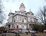
is Newark
and is named for the salt lick
s that were in the area.
Licking County is part of the Columbus
Metropolitan Statistical Area.
 According to the U.S. Census Bureau
, the county has a total area of 688 square miles (1,781.9 km²).686 square miles (1,776.7 km²) is land and 2 square miles (5.2 km²) (0.27%) is water.
of 2000, there were 146,491 people, 55,609 households, and 40,149 families residing in the county. The population density
was 212 people per square mile (82/km²). There were 58,760 housing units at an average density of 86 per square mile (33/km²). The racial makeup of the county was 95.64% White
, 2.06% Black
or African American
, 0.30% Native American
, 0.58% Asian
, 0.02% Pacific Islander
, 0.30% from other races
, and 1.10% from two or more races. 0.76% of the population were Hispanic
or Latino
of any race.
There were 55,609 households out of which 34.40% had children under the age of 18 living with them, 58.50% were married couples
living together, 10.00% had a female householder with no husband present, and 27.80% were non-families. 23.10% of all households were made up of individuals and 9.10% had someone living alone who was 65 years of age or older. The average household size was 2.56 and the average family size was 3.01.
In the county, the population was spread out with 26.00% under the age of 18, 8.80% from 18 to 24, 29.40% from 25 to 44, 23.90% from 45 to 64, and 11.90% who were 65 years of age or older. The median age was 37 years. For every 100 females there were 94.80 males. For every 100 females age 18 and over, there were 92.00 males.
The median income for a household in the county was $44,124, and the median income for a family was $51,969. Males had a median income of $37,957 versus $26,884 for females. The per capita income
for the county was $20,581. About 5.50% of families and 7.50% of the population were below the poverty line, including 9.10% of those under age 18 and 7.50% of those age 65 or over.
 Licking County has long been a hotbed for high school sports due to the many high school athletic programs in the county, including Granville High School, Heath High School
, Johnstown-Monroe High School
, Lakewood High School
, Licking Valley High School
, Licking Heights High School
, Licking County Christian Academy, Newark Catholic High School
, Newark High School
, Northridge High School
, Utica High School
,and Watkins Memorial High School
. In baseball, a state title has been won by a Licking County high school team every year dating back to 2002. It was in that year that three Licking County teams won state titles. Newark Catholic High School and Heath High School alone have combined for nine state titles in just a six year span.
Licking County schools recently won at least one state title in four straight sport seasons: Heath in both Boys Track and Boys Baseball (2007), Newark Catholic in Football (2007), Newark in Boys Basketball (2008) and Lakewood in Softball (2008).
U.S. state
A U.S. state is any one of the 50 federated states of the United States of America that share sovereignty with the federal government. Because of this shared sovereignty, an American is a citizen both of the federal entity and of his or her state of domicile. Four states use the official title of...
of Ohio
Ohio
Ohio is a Midwestern state in the United States. The 34th largest state by area in the U.S.,it is the 7th‑most populous with over 11.5 million residents, containing several major American cities and seven metropolitan areas with populations of 500,000 or more.The state's capital is Columbus...
, United States
United States
The United States of America is a federal constitutional republic comprising fifty states and a federal district...
. As of the 2010 census, the population was 166,492. http://quickfacts.census.gov/qfd/states/39/39089.html Its county seat
County seat
A county seat is an administrative center, or seat of government, for a county or civil parish. The term is primarily used in the United States....
is Newark
Newark, Ohio
In addition, the remains of a road leading south from the Octagon have been documented and explored. It was first surveyed in the 19th century, when its walls were more apparent. Called the Great Hopewell Road, it may extend to the Hopewell complex at Chillicothe, Ohio...
and is named for the salt lick
Salt lick
A mineral lick is a natural mineral deposit where animals in nutrient-poor ecosystems can obtain essential mineral nutrients...
s that were in the area.
Licking County is part of the Columbus
Columbus, Ohio
Columbus is the capital of and the largest city in the U.S. state of Ohio. The broader metropolitan area encompasses several counties and is the third largest in Ohio behind those of Cleveland and Cincinnati. Columbus is the third largest city in the American Midwest, and the fifteenth largest city...
Metropolitan Statistical Area.
Geography
United States Census Bureau
The United States Census Bureau is the government agency that is responsible for the United States Census. It also gathers other national demographic and economic data...
, the county has a total area of 688 square miles (1,781.9 km²).686 square miles (1,776.7 km²) is land and 2 square miles (5.2 km²) (0.27%) is water.
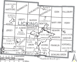
Adjacent counties
- Knox CountyKnox County, OhioKnox County is a county located in the state of Ohio, United States. As of 2010, the population was 60,921. Its county seat is Mount Vernon and is named for Henry Knox, an officer in the American Revolutionary War who was later the first Secretary of War....
(north) - Coshocton CountyCoshocton County, OhioCoshocton County is a county located in the state of Ohio, United States. As of the 2010 census, the population was 36,901. Its county seat is Coshocton. Its name comes from the Delaware Indian language and has been translated as "union of waters" or "black bear crossing".The Coshocton...
(northeast) - Muskingum CountyMuskingum County, OhioMuskingum County is a county located in the state of Ohio, United States. As of the 2010 census, the population was 86,074. Its county seat is Zanesville...
(east) - Perry CountyPerry County, OhioPerry County is a county located in the state of Ohio, United States. Founded on March 1, 1818, it was the 55th county to be formed in Ohio. Portions of Fairfield, Washington and Muskingum Counties were taken to create Perry County. As of the 2010 census, the population was 36,058. Its county seat...
(southeast) - Fairfield CountyFairfield County, OhioFairfield County is a county located in the state of Ohio, United States. As of 2010, the population was 146,156. Its county seat is Lancaster. Its name is a reference to the Fairfield area of the original Lancaster....
(southwest) - Franklin CountyFranklin County, OhioFranklin County is a county located in the state of Ohio, United States. In 2010 the population was 1,163,414, making it the second largest county in Ohio and the 34th largest county in population in the United States. Franklin County is also the largest in the eight-county Columbus, Ohio...
(west) - Delaware CountyDelaware County, OhioDelaware County is a fast-growing suburban county in the state of Ohio, United States, within the Columbus, Ohio Metropolitan Statistical Area. According to the United States Census Bureau's 2004 population estimates, Delaware County's population of 142,503 made it the fastest growing county in...
(northwest)
History
Licking County was formed on January 30, 1808 from portions of Fairfield County. It was named after the salt licks which were to be found in the area.Demographics
As of the censusCensus
A census is the procedure of systematically acquiring and recording information about the members of a given population. It is a regularly occurring and official count of a particular population. The term is used mostly in connection with national population and housing censuses; other common...
of 2000, there were 146,491 people, 55,609 households, and 40,149 families residing in the county. The population density
Population density
Population density is a measurement of population per unit area or unit volume. It is frequently applied to living organisms, and particularly to humans...
was 212 people per square mile (82/km²). There were 58,760 housing units at an average density of 86 per square mile (33/km²). The racial makeup of the county was 95.64% White
Race (United States Census)
Race and ethnicity in the United States Census, as defined by the Federal Office of Management and Budget and the United States Census Bureau, are self-identification data items in which residents choose the race or races with which they most closely identify, and indicate whether or not they are...
, 2.06% Black
Race (United States Census)
Race and ethnicity in the United States Census, as defined by the Federal Office of Management and Budget and the United States Census Bureau, are self-identification data items in which residents choose the race or races with which they most closely identify, and indicate whether or not they are...
or African American
Race (United States Census)
Race and ethnicity in the United States Census, as defined by the Federal Office of Management and Budget and the United States Census Bureau, are self-identification data items in which residents choose the race or races with which they most closely identify, and indicate whether or not they are...
, 0.30% Native American
Race (United States Census)
Race and ethnicity in the United States Census, as defined by the Federal Office of Management and Budget and the United States Census Bureau, are self-identification data items in which residents choose the race or races with which they most closely identify, and indicate whether or not they are...
, 0.58% Asian
Race (United States Census)
Race and ethnicity in the United States Census, as defined by the Federal Office of Management and Budget and the United States Census Bureau, are self-identification data items in which residents choose the race or races with which they most closely identify, and indicate whether or not they are...
, 0.02% Pacific Islander
Race (United States Census)
Race and ethnicity in the United States Census, as defined by the Federal Office of Management and Budget and the United States Census Bureau, are self-identification data items in which residents choose the race or races with which they most closely identify, and indicate whether or not they are...
, 0.30% from other races
Race (United States Census)
Race and ethnicity in the United States Census, as defined by the Federal Office of Management and Budget and the United States Census Bureau, are self-identification data items in which residents choose the race or races with which they most closely identify, and indicate whether or not they are...
, and 1.10% from two or more races. 0.76% of the population were Hispanic
Race (United States Census)
Race and ethnicity in the United States Census, as defined by the Federal Office of Management and Budget and the United States Census Bureau, are self-identification data items in which residents choose the race or races with which they most closely identify, and indicate whether or not they are...
or Latino
Race (United States Census)
Race and ethnicity in the United States Census, as defined by the Federal Office of Management and Budget and the United States Census Bureau, are self-identification data items in which residents choose the race or races with which they most closely identify, and indicate whether or not they are...
of any race.
There were 55,609 households out of which 34.40% had children under the age of 18 living with them, 58.50% were married couples
Marriage
Marriage is a social union or legal contract between people that creates kinship. It is an institution in which interpersonal relationships, usually intimate and sexual, are acknowledged in a variety of ways, depending on the culture or subculture in which it is found...
living together, 10.00% had a female householder with no husband present, and 27.80% were non-families. 23.10% of all households were made up of individuals and 9.10% had someone living alone who was 65 years of age or older. The average household size was 2.56 and the average family size was 3.01.
In the county, the population was spread out with 26.00% under the age of 18, 8.80% from 18 to 24, 29.40% from 25 to 44, 23.90% from 45 to 64, and 11.90% who were 65 years of age or older. The median age was 37 years. For every 100 females there were 94.80 males. For every 100 females age 18 and over, there were 92.00 males.
The median income for a household in the county was $44,124, and the median income for a family was $51,969. Males had a median income of $37,957 versus $26,884 for females. The per capita income
Per capita income
Per capita income or income per person is a measure of mean income within an economic aggregate, such as a country or city. It is calculated by taking a measure of all sources of income in the aggregate and dividing it by the total population...
for the county was $20,581. About 5.50% of families and 7.50% of the population were below the poverty line, including 9.10% of those under age 18 and 7.50% of those age 65 or over.
Places of interest
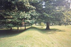
- Newark EarthworksNewark EarthworksThe Newark Earthworks in Newark and Heath, Ohio, consists of three sections of preserved earthworks: the Great Circle Earthworks, the Octagon Earthworks, and the Wright Earthworks. This complex contained the largest earthen enclosures in the world, being about 3,000 acres in extent. Today, the...
- Blackhand Gorge State Nature Preserve
- Flint Ridge State MemorialFlint Ridge State MemorialFlint Ridge State Memorial is a Native American flint quarry located in Hopewell Township, Licking County, Ohio, about three miles north of Brownsville at the intersection of Brownsville Road and Flint Ridge Road...
- Dawes ArboretumDawes ArboretumThe Dawes Arboretum is a non-profit arboretum located outside of Columbus in Newark, Ohio. As one of the premier public gardens in North America, The Dawes Arboretum has over of plant collections, gardens and natural areas...
- Ye Olde Mill in UticaUtica, OhioUtica is a village in Knox and Licking counties in the U.S. state of Ohio, along the North Fork of the Licking River. The population was 2,130 at the 2000 census....
(where Velvet ice cream is produced) http://www.velveticecream.com/olde_mill.asp - Heisey GlassHeisey Glass CompanyThe A.H. Heisey Company was formed in Newark, Ohio, in 1895 by A.H. Heisey. The factory provided fine quality glass tableware and decorative glass figurines...
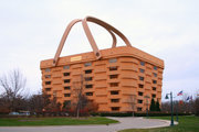
Museum http://www.heiseymuseum.org/ - LongabergerThe Longaberger CompanyThe Longaberger Company is an American manufacturer of handcrafted maple wood baskets and offers other home and lifestyle products, including pottery, wrought iron, fabric accessories and specialty foods. It is one of the primary employers in the southeastern Ohio area near Dresden, Ohio. Started...
Basket Facility (Main office building is a 7-story replica basket, the largest in the world) - National Trail Raceway - NHRA Approved Dragway http://www.nationaltrailraceway.com
- Denison UniversityDenison UniversityDenison University is private, coeducational, and residential college of liberal arts and sciences founded in 1831. It is located in Granville, Ohio, United States, approximately 30 miles east of Columbus, the state capital...
Sports
Heath High School (Ohio)
Heath High School is a public high school in Heath, Ohio. It is the only high school in the Heath City Schools district.-Ohio High School Athletic Association State Championships:* Boys Baseball – 2002, 2007 * Boys Track and Field - 2007...
, Johnstown-Monroe High School
Johnstown-Monroe High School
Johnstown-Monroe High School is a public high school in Johnstown, Ohio. It is the only high school in the Johnstown-Monroe Local School District. It was erected in 1963 and currently houses grades 9-12. It contains a cafeteria, gymnasium, performing arts center,and music room. The current...
, Lakewood High School
Lakewood High School (Hebron, Ohio)
Lakewood High School is a public high school in Hebron, Ohio, United States. It is the only high school in the Lakewood Local Schools district. Their nickname is the Lancers.-Ohio High School Athletic Association State Championships:...
, Licking Valley High School
Licking Valley High School
Licking Valley High School is a public high school in Hanover, Ohio that is overseen by district superintendent David Hile. It is the only high school in the Licking Valley Local School District...
, Licking Heights High School
Licking Heights High School
Licking Heights High School is a public high school in Pataskala, Ohio. It is the only high school in the Licking Heights Local School District...
, Licking County Christian Academy, Newark Catholic High School
Newark Catholic High School
Newark Catholic High School is a private, Catholic co-educational high school located in Newark, Ohio in Licking County. It is operated by the Roman Catholic Diocese of Columbus.-Mission statement:...
, Newark High School
Newark High School (Ohio)
Newark High School is a public high school in Newark, Ohio. It houses a little more than 2,000 students. It is the only high school in the Newark City Schools district. Newark High School previously featured a college campus that is now under construction...
, Northridge High School
Northridge High School (Johnstown, Ohio)
Northridge High School is located in rural northwestern Licking County, Ohio, and serves several townships in that part of the county, as well as a part of southern Knox County, Ohio. It has a USPS address of Johnstown, Ohio, although it is about five miles northeast of that town.The original High...
, Utica High School
Utica High School (Ohio)
Utica Sr. High School is a public high school in Utica, Ohio. The North Fork School District, named so because Utica, Ohio, is located on the North Fork of the Licking River. The North Fork School District is located in southern Knox County and Northern Licking County...
,and Watkins Memorial High School
Watkins Memorial High School
Watkins Memorial High School is a public high school near Pataskala, Ohio. It is the only high school in the Southwest Licking School System, which was formed in 1955 by the merger of Etna, Kirkersville, and Pataskala high schools. The school's nickname is the Warriors.The school was named in...
. In baseball, a state title has been won by a Licking County high school team every year dating back to 2002. It was in that year that three Licking County teams won state titles. Newark Catholic High School and Heath High School alone have combined for nine state titles in just a six year span.
Licking County schools recently won at least one state title in four straight sport seasons: Heath in both Boys Track and Boys Baseball (2007), Newark Catholic in Football (2007), Newark in Boys Basketball (2008) and Lakewood in Softball (2008).
Localities
Municipalities
|
Heath, Ohio As of the census of 2000, there were 8,527 people, 3,403 households, and 2,375 families residing in the city. The population density was 816.6 people per square mile . There were 3,593 housing units at an average density of 344.1 per square mile... Hebron, Ohio Hebron is a village in Licking County, Ohio, United States. The population was 2,034 at the 2000 census.-Geography:Hebron is located at .According to the United States Census Bureau, the village has a total area of , all of it land.... Johnstown, Ohio As of the census of 2000, there were 3,440 people, 1,396 households, and 932 families residing in the village. The population density was 1,643.0 people per square mile . There were 1,453 housing units at an average density of 694.0 per square mile... Kirkersville, Ohio Kirkersville is a village in Licking County, Ohio, United States, along the South Fork of the Licking River. The population was 520 at the 2000 census.-Geography:Kirkersville is located at .... Newark, Ohio In addition, the remains of a road leading south from the Octagon have been documented and explored. It was first surveyed in the 19th century, when its walls were more apparent. Called the Great Hopewell Road, it may extend to the Hopewell complex at Chillicothe, Ohio... |
New Albany, Ohio As of the census of 2000, there were 3,711 people, 1,263 households, and 1,030 families residing in the village. The population density was 415.7 people per square mile . There were 1,424 housing units at an average density of 159.5 per square mile... Pataskala, Ohio Pataskala is a city in Licking County, Ohio, United States. The population was 10,249 at the 2000 census. Pataskala was a small community until 1996, when what was then the village of Pataskala merged with Lima Township, vastly increasing its population and geographic area.-Geography:Pataskala is... Reynoldsburg, Ohio Reynoldsburg is a city in Fairfield, Franklin, and Licking counties in the U.S. state of Ohio. It is a suburban community in the Columbus, Ohio metropolitan area... St. Louisville, Ohio St. Louisville is a village in Licking County, Ohio, United States, along the North Fork of the Licking River. The population was 346 at the 2000 census.-Geography:St... Utica, Ohio Utica is a village in Knox and Licking counties in the U.S. state of Ohio, along the North Fork of the Licking River. The population was 2,130 at the 2000 census.... |
Townships
|
Harrison Township, Licking County, Ohio Harrison Township is one of the twenty-five townships of Licking County, Ohio, United States. The 2000 census found 6,494 people in the township, 5,974 of whom lived in the unincorporated portions of the township.-Geography:... Hartford Township, Licking County, Ohio Hartford Township is one of the twenty-five townships of Licking County, Ohio, United States. The 2000 census found 1,290 people in the township, 878 of whom lived in the unincorporated portions of the township.-Geography:... Hopewell Township, Licking County, Ohio Hopewell Township is one of the twenty-five townships of Licking County, Ohio, United States. The 2000 census found 1,200 people in the township, 1,104 of whom lived in the unincorporated portions of the township.-Geography:... Jersey Township, Licking County, Ohio Jersey Township is one of the twenty-five townships of Licking County, Ohio, United States. The 2000 census found 2,841 people in the township.-Geography:Located on the western edge of the county, it borders the following townships and city:... Liberty Township, Licking County, Ohio Liberty Township is one of the twenty-five townships of Licking County, Ohio, United States. The 2000 census found 1,797 people in the township.-Geography:Located in the northwestern part of the county, it borders the following townships:... Licking Township, Licking County, Ohio Licking Township is one of the twenty-five townships of Licking County, Ohio, United States. The 2000 census found 3,870 people in the township.-Geography:Located on the southern edge of the county, it borders the following townships and city:... Madison Township, Licking County, Ohio Madison Township is one of the twenty-five townships of Licking County, Ohio, United States. The 2000 census found 3,061 people in the township.-Geography:Located in the eastern part of the county, it borders the following townships and city:... Mary Ann Township, Licking County, Ohio Mary Ann Township is one of the twenty-five townships of Licking County, Ohio, United States. The 2000 census found 2,118 people in the township.-Geography:Located in the northeastern part of the county, it borders the following townships:... |
McKean Township, Licking County, Ohio McKean Township is one of the twenty-five townships of Licking County, Ohio, United States. The 2000 census found 1,516 people in the township.-Geography:Located in the northern part of the county, it borders the following townships:... Monroe Township, Licking County, Ohio Monroe Township is one of the twenty-five townships of Licking County, Ohio, United States. The 2000 census found 5,523 people in the township, 2,083 of whom lived in the unincorporated portions of the township.-Geography:... Newark Township, Licking County, Ohio Newark Township is one of the twenty-five townships of Licking County, Ohio, United States. The 2000 census found 1,976 people in the township.-Geography:Located in the center of the county, it borders the following townships and city:... Newton Township, Licking County, Ohio Newton Township is one of the twenty-five townships of Licking County, Ohio, United States. The 2000 census found 3,111 people in the township, 2,765 of whom lived in the unincorporated portions of the township.-Geography:... Perry Township, Licking County, Ohio Perry Township is one of the twenty-five townships of Licking County, Ohio, United States. The 2000 census found 1,492 people in the township.-Geography:Located on the eastern edge of the county, it borders the following townships:... St. Albans Township, Licking County, Ohio St. Albans Township is one of the twenty-five townships of Licking County, Ohio, United States. The 2000 census found 2,060 people in the township, 1,975 of whom lived in the unincorporated portions of the township.-Geography:... Union Township, Licking County, Ohio Union Township is one of the twenty-five townships of Licking County, Ohio, United States. The 2000 census found 8,339 people in the township, 3,259 of whom lived in the unincorporated portions of the township.-Geography:... Washington Township, Licking County, Ohio Washington Township is one of the twenty-five townships of Licking County, Ohio, United States. The 2000 census found 3,045 people in the township, 917 of whom lived in the unincorporated portions of the township.-Geography:... |
Census-designated places
|
Harbor Hills, Ohio Harbor Hills is a census-designated place in Licking County, Ohio, United States. The population was 1,303 at the 2000 census.-Geography:Harbor Hills is located at .... Marne, Ohio Marne is a census-designated place in Licking County, Ohio, United States. The population was 783 at the 2010 census.-Demographics:As of the census of 2010, there were 783 people, 289 households, and 228 families residing in the CDP. There were 301 housing units... |
Other places
|
Homer, Ohio Homer is an unincorporated community in northern Burlington Township, Licking County, Ohio, United States. Although it is unincorporated, it has a post office, with the ZIP code of 43027. It lies along State Route 661 between Granville and Mount Vernon.... |
Jacksontown, Ohio Jacksontown is an unincorporated community in central Licking Township, Licking County, Ohio, United States. Although it is unincorporated, it has a post office, with the ZIP code of 43030. It lies at the intersection of U.S. Route 40 with State Route 13.... |