
Yagul
Encyclopedia
Yagul is an archaeological site
and former city-state
associated with the Zapotec civilization
of pre-Columbian
Mesoamerica
, located in the Mexican state of Oaxaca
. The site was declared one of the country's four Natural Monument
s on 13 October 1998. The site is also known locally as Pueblo Viejo (Old Village) and was occupied at the time of the Spanish Conquest. After the Conquest the population was relocated to the nearby modern town of Tlacolula where their descendants still live.
Yagul was first occupied around 500-100 BC. Around 500-700 AD, residential, civic and ceremonial structures were built at the site. However, most of the visible remains date to 1250-1521 AD, when the site functioned as the capital of a Postclassic
city-state.
The site was excavated in the 1950s and 60s by archaeologists Ignacio Bernal
and John Paddock.
Vestiges of human habitation in the area, namely cliff paintings at Caballito Blanco, date to at least 3000 BCE. After the abandonment of Monte Albán
about 800 CE, the region's inhabitants established themselves in various small centers such as Lambityeco
, Mitla
and Yagul.
, it is formed from ya (tree) and gul (old), hence "old tree".
and Mitla
, about 36 km from the former. The site is situated on a volcanic outcrop surrounded by fertile alluvial land, in the Tlacolula arm of the Valley of Oaxaca. The Salado river flows to the south.
. Elaborate Preclassic period burials have been excavated at Yagul, accompanied by ceramic effigy vessels that indicate the increasing influence of Monte Albán upon the local elite.
In the Late Postclassic
, immediately prior to the Spanish Conquest, Yagul had a population of more than 6000 people.
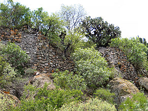 Situated atop the cliffs to the northeast of the site and protected by natural and artificial walls, it has an excellent vantage point over the whole Tlacolula Valley
. It has several lookout points, including one reached by a narrow bridge.
The site is in the care of the Instituto Nacional de Antropología e Historia (National Institute of Anthropology and History) and is open to the public.
Archaeological site
An archaeological site is a place in which evidence of past activity is preserved , and which has been, or may be, investigated using the discipline of archaeology and represents a part of the archaeological record.Beyond this, the definition and geographical extent of a 'site' can vary widely,...
and former city-state
City-state
A city-state is an independent or autonomous entity whose territory consists of a city which is not administered as a part of another local government.-Historical city-states:...
associated with the Zapotec civilization
Zapotec civilization
The Zapotec civilization was an indigenous pre-Columbian civilization that flourished in the Valley of Oaxaca of southern Mesoamerica. Archaeological evidence shows their culture goes back at least 2500 years...
of pre-Columbian
Pre-Columbian
The pre-Columbian era incorporates all period subdivisions in the history and prehistory of the Americas before the appearance of significant European influences on the American continents, spanning the time of the original settlement in the Upper Paleolithic period to European colonization during...
Mesoamerica
Mesoamerica
Mesoamerica is a region and culture area in the Americas, extending approximately from central Mexico to Belize, Guatemala, El Salvador, Honduras, Nicaragua, and Costa Rica, within which a number of pre-Columbian societies flourished before the Spanish colonization of the Americas in the 15th and...
, located in the Mexican state of Oaxaca
Oaxaca
Oaxaca , , officially Estado Libre y Soberano de Oaxaca is one of the 31 states which, along with the Federal District, comprise the 32 federative entities of Mexico. It is divided into 571 municipalities; of which 418 are governed by the system of customs and traditions...
. The site was declared one of the country's four Natural Monument
Mexican Natural Monuments
Mexico's Natural Monuments are four federally-recognized protected natural areas that are administrated by the federal National Commission of Protected Natural Areas ....
s on 13 October 1998. The site is also known locally as Pueblo Viejo (Old Village) and was occupied at the time of the Spanish Conquest. After the Conquest the population was relocated to the nearby modern town of Tlacolula where their descendants still live.
Yagul was first occupied around 500-100 BC. Around 500-700 AD, residential, civic and ceremonial structures were built at the site. However, most of the visible remains date to 1250-1521 AD, when the site functioned as the capital of a Postclassic
Mesoamerican chronology
Mesoamerican chronology divides the history of pre-Columbian Mesoamerica into several periods: the Paleo-Indian , the Archaic , the Preclassic , the Classic , and the Postclassic...
city-state.
The site was excavated in the 1950s and 60s by archaeologists Ignacio Bernal
Ignacio Bernal
Ignacio Bernal was an eminent Mexican anthropologist and archaeologist.Bernal excavated much of Monte Albán, originally starting as a student of Alfonso Caso, and later led major archeological projects at Teotihuacan. In 1965 he excavated Dainzú...
and John Paddock.
Vestiges of human habitation in the area, namely cliff paintings at Caballito Blanco, date to at least 3000 BCE. After the abandonment of Monte Albán
Monte Albán
Monte Albán is a large pre-Columbian archaeological site in the Santa Cruz Xoxocotlán Municipality in the southern Mexican state of Oaxaca...
about 800 CE, the region's inhabitants established themselves in various small centers such as Lambityeco
Lambityeco
Lambityeco is a small archaeological site just about 3 kilometers west of the Tlacolula city in the Mexican state of Oaxaca. It is located just off Highway 190 about east from the city of Oaxaca enroute to Mitla. The site has been securely dated to the Late Classical Period.The Lambityeco name has...
, Mitla
Mitla
Mitla is the second most important archeological site in the state of Oaxaca in Mexico, and the most important of the Zapotec culture. The site is located 44 km from the city of Oaxaca. in the upper end of the Tlacolula Valley, one of the three that form the Central Valleys Region of the...
and Yagul.
Etymology
Yagul comes from the Zapotec languageZapotec language
The Zapotec language are a group of closely related indigenous Mesoamerican languages spoken by the Zapotec people from the southwestern-central highlands of Mexico. Present-day native speakers are estimated to number over half a million, with the majority inhabiting the state of Oaxaca....
, it is formed from ya (tree) and gul (old), hence "old tree".
Location
Yagul is located just off Highway 190 between the city of OaxacaOaxaca, Oaxaca
The city and municipality of Oaxaca de Juárez, or simply Oaxaca, is the capital and largest city of the Mexican state of the same name . It is located in the Centro District in the Central Valleys region of the state, in the foothills of the Sierra Madre at the base of the Cerro del Fortín...
and Mitla
Mitla
Mitla is the second most important archeological site in the state of Oaxaca in Mexico, and the most important of the Zapotec culture. The site is located 44 km from the city of Oaxaca. in the upper end of the Tlacolula Valley, one of the three that form the Central Valleys Region of the...
, about 36 km from the former. The site is situated on a volcanic outcrop surrounded by fertile alluvial land, in the Tlacolula arm of the Valley of Oaxaca. The Salado river flows to the south.
Site history
Occupation at Yagul dates as far back as the Middle to Late PreclassicMesoamerican chronology
Mesoamerican chronology divides the history of pre-Columbian Mesoamerica into several periods: the Paleo-Indian , the Archaic , the Preclassic , the Classic , and the Postclassic...
. Elaborate Preclassic period burials have been excavated at Yagul, accompanied by ceramic effigy vessels that indicate the increasing influence of Monte Albán upon the local elite.
In the Late Postclassic
Mesoamerican chronology
Mesoamerican chronology divides the history of pre-Columbian Mesoamerica into several periods: the Paleo-Indian , the Archaic , the Preclassic , the Classic , and the Postclassic...
, immediately prior to the Spanish Conquest, Yagul had a population of more than 6000 people.
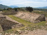
Site description
Yagul is one of the most studied archaeological sites in the Valley of Oaxaca.This important prehispanic centers name literally means "Old Stick" or "Old Tree", The site is set around a hill, and can be divided into three principal areas; the fortress, the ceremonial center and the residential areas. The construction stone at Yagul is mainly river cobbles formed from volcanic rock such as basalt. About 30 tombs have been found at Yagul, sometimes located in pairs. A few of these bear hieroglyphic inscriptions.Fortress
Valley of Oaxaca
The Valley of Oaxaca is a geographic region located within the modern day State of Oaxaca in southern Mexico. The valley, which is located within the Sierra Madre Mountains, is shaped like a distorted and almost upside-down “Y,” with each of its arms bearing specific names: the northwestern Etla...
. It has several lookout points, including one reached by a narrow bridge.
Residential area
Unexcavated residential areas lie on terraces to the south, east and west of the hill. Classic Period residences are to the northwest of the excavated ceremonial centre and lower class Postclassic residences are presumed to lie around the site core.Ceremonial center
The ceremonial center was excavated in 1974 by Bernal and Gamio. It composes the vast majority of what has been excavated, and what can be seen today. The ceremonial center consists of a number of large patios bordered by monumental architecture, and also includes a ballcourt and an elite residential complex. Some of the structures in this area are:- Ballcourt. The restored ballcourt has an east-west orientation and is the largest in the Valley of OaxacaValley of OaxacaThe Valley of Oaxaca is a geographic region located within the modern day State of Oaxaca in southern Mexico. The valley, which is located within the Sierra Madre Mountains, is shaped like a distorted and almost upside-down “Y,” with each of its arms bearing specific names: the northwestern Etla...
. A carved serpent's head, now in the Regional Museum in OaxacaOaxaca, OaxacaThe city and municipality of Oaxaca de Juárez, or simply Oaxaca, is the capital and largest city of the Mexican state of the same name . It is located in the Centro District in the Central Valleys region of the state, in the foothills of the Sierra Madre at the base of the Cerro del Fortín...
, was found fixed to the top of the south wall. The ballcourt was built in the Classic Period between 500 and 700 AD, and then widened between 700 and 900 AD. It has a total length of 47 meters and a central field length of 30 meters, and is 6 meters wide.
- Palace of the Six Patios. This is a labyrinthine structure formed of an intricate complex of passageways and many rooms. It is formed of three elite complexes, each with two patios surrounded by rooms. In each pair of patios, the northern was probably a residence and the southern was possibly the administrative area. A tomb entrance is found in each patio. The same layout is found at the nearby site of MitlaMitlaMitla is the second most important archeological site in the state of Oaxaca in Mexico, and the most important of the Zapotec culture. The site is located 44 km from the city of Oaxaca. in the upper end of the Tlacolula Valley, one of the three that form the Central Valleys Region of the...
although the two sites were probably independent. The walls are faced with dressed stones and stucco over a rough stone and clay core, the floors were of red stucco. Patio F is somewhat different from the others in the complex in that it opened out onto the ballcourt and lower patio complexes and appears to have had a more public function. It had a low bench situated within a room that would have been visible to the areas below and may have been intended for the reception of visitors. The palace complex also included a temple.
- Patio 1 is a large open area immediately southeast of the Palace of the Six Patios. It has rooms on all sides except the south side. Immediately to the south of Patio 1 is a temple.
- Patio 4 lies to the southeast of the ballcourt and is part of a temple-patio-altar complex formed from four mounds around a central altar. It was in use from at least the Classic PeriodMesoamerican chronologyMesoamerican chronology divides the history of pre-Columbian Mesoamerica into several periods: the Paleo-Indian , the Archaic , the Preclassic , the Classic , and the Postclassic...
through to the PostclassicMesoamerican chronologyMesoamerican chronology divides the history of pre-Columbian Mesoamerica into several periods: the Paleo-Indian , the Archaic , the Preclassic , the Classic , and the Postclassic...
. A sculpture of a frog-effigy lies at the base of the eastern mound.
- Tomb 30. This Postclassic tomb lies underneath Patio 4. It is formed of three chambers with decorated panels, the principal chamber has a facade decorated with two human heads carved in stone. The door to the tomb is a stone slab with hieroglyphic inscriptions on both sides.
- Council Chamber. This is a long, narrow chamber with an east-west orientation, lying to the south of a narrow "street". It was once decorated with stone mosaics and was entered via steps from Patio 1, which lies immediately to the south. The entrance is divided into 3 sections by two 2-meter wide pillars. Due to its non-residential nature and its lack of a shrine or temple, this room is presumed to have been administrative in function.
- Decorated Street. This narrow "street" runs in an east-west direction between the Palace of the Six Patios to the north and the Council Chamber to the south. Its southern wall is over 40 meters long and was decorated with geometric stone mosaics similar to those at MitlaMitlaMitla is the second most important archeological site in the state of Oaxaca in Mexico, and the most important of the Zapotec culture. The site is located 44 km from the city of Oaxaca. in the upper end of the Tlacolula Valley, one of the three that form the Central Valleys Region of the...
.
- Building U. This building was built on an artificial platform in the northern part of the site, a tomb lies under its floor. It is reached by a stairway to the south and has a good view across most of the site.
The site is in the care of the Instituto Nacional de Antropología e Historia (National Institute of Anthropology and History) and is open to the public.