

Juchitán District, Oaxaca
Encyclopedia
Juchitán District is located in the east of the Istmo de Tehuantepec region
of the State of Oaxaca
, Mexico
, covering the southern part of a low lying corridor through the mountains that separates the Gulf of Mexico
from the Pacific ocean
.
The district has an area of 13,300 km2 and a population as of 2005 of 339,445.
The district is relatively flat in the southern coastal plain, bounded by lagoons and then the ocean.
Inland to the north it is hillier, rising to the crest of the isthmus and then descending towards the Veracruz
coastal plain of the Gulf of Mexico. The land rises to mountains to the West (Sierra Madre de Oaxaca
) and the East (Sierra Madre de Chiapas
).
The municipalities of Santa María Chimalapa
and San Miguel Chimalapa
contain a large part of the Selva Zoque
, the largest tract of tropical rainforest
in Mexico, which contains the majority of terrestrial biodiversity in the country.
The government has plans to develop the trans-isthmus corridor. This includes improving transportation routes across the isthmus between the Caribbean and the Pacific, and developing an industrial zone along the highway. Other plans include creating coffee plantations and cattle corridors, expanding production of beans, maize and chili and exploiting the bio-genetic resources of native medicinal plants.
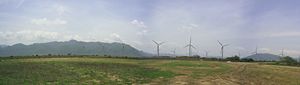 The isthmus has reliable, dominant north-south winds.
Some pilot wind farms have been built, notably at La Venta.
There are plans to build more, although there has been local resistance due to the communal ownership of land and concerns that the annual rental prices offered are too low
A plan first proposed in 1977 for a dam in the Chimalapas has been stalled due to environmental concerns.
In June 2008 the State of Oaxaca was again proposing construction of a storage dam in the Rio El Corte Basin in the Chimalapa sub-region, with the potential to irrigate 100,000 hectares of the Isthmus of Tehuantepec and to supply water to the Salina Cruz Refinery.
Istmo de Tehuantepec, Oaxaca
Istmo de Tehuantepec is the largest region in the state of Oaxaca, Mexico. It covers the southern part of the Isthmus of Tehuantepec, the shortest route between the Gulf of Mexico and the Pacific Ocean before the Panama Canal was opened....
of the State of Oaxaca
Oaxaca
Oaxaca , , officially Estado Libre y Soberano de Oaxaca is one of the 31 states which, along with the Federal District, comprise the 32 federative entities of Mexico. It is divided into 571 municipalities; of which 418 are governed by the system of customs and traditions...
, Mexico
Mexico
The United Mexican States , commonly known as Mexico , is a federal constitutional republic in North America. It is bordered on the north by the United States; on the south and west by the Pacific Ocean; on the southeast by Guatemala, Belize, and the Caribbean Sea; and on the east by the Gulf of...
, covering the southern part of a low lying corridor through the mountains that separates the Gulf of Mexico
Gulf of Mexico
The Gulf of Mexico is a partially landlocked ocean basin largely surrounded by the North American continent and the island of Cuba. It is bounded on the northeast, north and northwest by the Gulf Coast of the United States, on the southwest and south by Mexico, and on the southeast by Cuba. In...
from the Pacific ocean
Pacific Ocean
The Pacific Ocean is the largest of the Earth's oceanic divisions. It extends from the Arctic in the north to the Southern Ocean in the south, bounded by Asia and Australia in the west, and the Americas in the east.At 165.2 million square kilometres in area, this largest division of the World...
.
The district has an area of 13,300 km2 and a population as of 2005 of 339,445.
Environment
The climate is warm.The district is relatively flat in the southern coastal plain, bounded by lagoons and then the ocean.
Inland to the north it is hillier, rising to the crest of the isthmus and then descending towards the Veracruz
Veracruz
Veracruz, formally Veracruz de Ignacio de la Llave officially Estado Libre y Soberano de Veracruz de Ignacio de la Llave , is one of the 31 states that, along with the Federal District, comprise the 32 federative entities of Mexico. It is divided in 212 municipalities and its capital city is...
coastal plain of the Gulf of Mexico. The land rises to mountains to the West (Sierra Madre de Oaxaca
Sierra Madre de Oaxaca
The Sierra Madre de Oaxaca is a mountain range in southern Mexico. It begins at Pico de Orizaba and extends in a southeasterly direction for 300 km until reaching the Isthmus of Tehuantepec...
) and the East (Sierra Madre de Chiapas
Sierra Madre de Chiapas
Sierra Madre is a mountain range which runs northwest-southeast from the state of Chiapas in Mexico across Guatemala and into El Salvador and Honduras. Most of the volcanoes of Guatemala are a part of this range.A narrow coastal plain lies south the range, between the Sierra Madre and the Pacific...
).
The municipalities of Santa María Chimalapa
Santa María Chimalapa
Santa María Chimalapa is a town and municipality in Oaxaca in south-western Mexico.It is part of the Juchitán District in the west of the Istmo de Tehuantepec region.-Environment:...
and San Miguel Chimalapa
San Miguel Chimalapa
San Miguel Chimalapa is a town and municipality in Oaxaca in south-western Mexico.It is part of the Juchitán District in the west of the Istmo de Tehuantepec region....
contain a large part of the Selva Zoque
Selva Zoque
The Selva Zoque , which includes the Chimalapas rain forest, is an area of great ecological importance in Mexico. Most of the forest lies in the state of Oaxaca but parts are in Chiapas and Veracruz....
, the largest tract of tropical rainforest
Tropical rainforest
A tropical rainforest is an ecosystem type that occurs roughly within the latitudes 28 degrees north or south of the equator . This ecosystem experiences high average temperatures and a significant amount of rainfall...
in Mexico, which contains the majority of terrestrial biodiversity in the country.
Economy
Other than in the towns of the trans-isthmus corridor in the west of the district, most people are engaged in agriculture. Near the coast, there is fishing activity, and in some inland areas fine lumber is extracted for use in furniture making.The government has plans to develop the trans-isthmus corridor. This includes improving transportation routes across the isthmus between the Caribbean and the Pacific, and developing an industrial zone along the highway. Other plans include creating coffee plantations and cattle corridors, expanding production of beans, maize and chili and exploiting the bio-genetic resources of native medicinal plants.
Some pilot wind farms have been built, notably at La Venta.
There are plans to build more, although there has been local resistance due to the communal ownership of land and concerns that the annual rental prices offered are too low
A plan first proposed in 1977 for a dam in the Chimalapas has been stalled due to environmental concerns.
In June 2008 the State of Oaxaca was again proposing construction of a storage dam in the Rio El Corte Basin in the Chimalapa sub-region, with the potential to irrigate 100,000 hectares of the Isthmus of Tehuantepec and to supply water to the Salina Cruz Refinery.
Municipalities
The district includes the following municipalities:| Municipality | Area km2 | 2005 Population |
Indigenous Population |
|---|---|---|---|
| Asunción Ixtaltepec Asunción Ixtaltepec Asunción Ixtaltepec is a town and municipality in Oaxaca in south-western Mexico.It is part of the Juchitán District in the west of the Istmo de Tehuantepec region.The town was founded in 1546.The name means "White Mountain".-Environment:... |
547 | 14,438 | 6,583 |
| Chahuites Chahuites Chahuites is a town and municipality in Oaxaca in south-western Mexico. The municipality covers an area of 160.75 km².It is part of the Juchitán District in the west of the Istmo de Tehuantepec region... |
161 | 9,929 | |
| Ciudad Ixtepec | 230 | 24,181 | 4,667 |
| El Barrio de La Soledad El Barrio de La Soledad El Barrio de La Soledad is a town and municipality in Oaxaca in south-western Mexico. The municipality covers an area of 233.48 km².It is part of the Juchitán District in the west of the Istmo de Tehuantepec region... |
233 | 13,439 | |
| El Espinal | 83 | 8,219 | |
| Juchitán de Zaragoza Juchitán de Zaragoza Juchitán de Zaragoza is an indigenous town in the southeast of the Mexican state of Oaxaca.It is part of the Juchitán District in the west of the Istmo de Tehuantepec region... |
415 | 85,869 | |
| Matías Romero Matías Romero Matías Romero is a town and municipality in Oaxaca in south-western Mexico. The municipality covers an area of 1,459.54 km².It is part of the Juchitán District in the west of the Istmo de Tehuantepec region.... |
1,460 | 38,421 | |
| Reforma de Pineda Reforma de Pineda Reforma de Pineda is a town and municipality in Oaxaca in south-western Mexico. The municipality covers an area of 193.92 km².It is part of the Juchitán District in the west of the Istmo de Tehuantepec region.... |
194 | 2,691 | |
| San Dionisio del Mar San Dionisio del Mar San Dionisio del Mar is a town and municipality in Oaxaca in south-western Mexico. It is part of the Juchitán District in the east of the Istmo de Tehuantepec region.The town is named after its patron saint.... |
237 | 5,165 | 2,639 |
| San Francisco del Mar San Francisco del Mar San Francisco del Mar is a town and municipality in Oaxaca in south-western Mexico. It is part of the Juchitán District in the west of the Istmo de Tehuantepec region.... |
401 | 6,874 | 926 |
| San Francisco Ixhuatán San Francisco Ixhuatán San Francisco Ixhuatán is a town, and the surrounding municipality of the same name, in the Mexican state of Oaxaca.It is part of the Juchitán District in the west of the Istmo de Tehuantepec region.... |
407 | 9,050 | |
| San Juan Guichicovi San Juan Guichicovi San Juan Guichicovi is a town and municipality in Oaxaca in south-western Mexico.It is part of the Juchitán District in the west of the Istmo de Tehuantepec region.The town was founded on 15 March 1825: Guichicovi means "New Town" in Zapotec.-Environment:... |
564 | 27,646 | 19,367 |
| San Miguel Chimalapa San Miguel Chimalapa San Miguel Chimalapa is a town and municipality in Oaxaca in south-western Mexico.It is part of the Juchitán District in the west of the Istmo de Tehuantepec region.... |
1,593 | 6,541 | 1,988 |
| San Pedro Tapanatepec San Pedro Tapanatepec San Pedro Tapanatepec is a town and municipality in Oaxaca in south-western Mexico. It is part of the Juchitán District in the west of the Istmo de Tehuantepec region.The town was founded on 23 April 1669, and became a municipality on March 15, 1825.... |
545 | 13,647 | 609 |
| Santa María Chimalapa Santa María Chimalapa Santa María Chimalapa is a town and municipality in Oaxaca in south-western Mexico.It is part of the Juchitán District in the west of the Istmo de Tehuantepec region.-Environment:... |
3,572 | 8,643 | 3,381 |
| Santa María Petapa Santa María Petapa Santa María Petapa is a town and municipality in Oaxaca in south-western Mexico.It is part of the Juchitán District in the west of the Istmo de Tehuantepec region.The name comes from the Zapotec language words meaning "four winds".... |
145 | 13,867 | 3,294 |
| Santa María Xadani Santa María Xadani Santa María Xadani is a town and municipality in Oaxaca in south-western Mexico.It is part of the Juchitán District in the west of the Istmo de Tehuantepec region.-Environment:The municipality covers an area of 89.31 km²... |
89 | 7,283 | 6,114 |
| Santiago Niltepec Santiago Niltepec Santiago Niltepec is a town and municipality in Oaxaca in south-western Mexico.It is part of the Juchitán District in the west of the Istmo de Tehuantepec region.The name means "Hill of Indigo."The town is 60 meters above sea level... |
680 | 4,961 | 56 |
| Santo Domingo Ingenio Santo Domingo Ingenio Santo Domingo Ingenio is a town and municipality in Oaxaca in south-western Mexico. It is part of the Juchitán District in the west of the Istmo de Tehuantepec region.-Environment:... |
355 | 7,299 | 465 |
| Santo Domingo Petapa Santo Domingo Petapa Santo Domingo Petapa is a town and municipality in Oaxaca in south-western Mexico. The municipality covers an area of 232.2 km², at an average altitude of 250 meters above sea level, and is part of the Juchitán District of the Istmo de Tehuantepec region.... |
232 | 7,583 | 2,696 |
| Santo Domingo Zanatepec Santo Domingo Zanatepec Santo Domingo Zanatepec is a town and municipality in Oaxaca in south-western Mexico.It is part of the Juchitán District in the west of the Istmo de Tehuantepec region.The municipality, established on 15 March 1825 covers an area of 1024.49 km².... |
1,024 | 10,716 | 211 |
| Unión Hidalgo Unión Hidalgo Unión Hidalgo is a town and municipality in Oaxaca in south-western Mexico.It is part of the Juchitán District in the west of the Istmo de Tehuantepec region.The municipality covers an area of 132.69 km² at an average height of 20 meters above sea level... |
133 | 12,983 | 7,230 |