

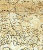
Valley of Mexico
Encyclopedia
Plateau
In geology and earth science, a plateau , also called a high plain or tableland, is an area of highland, usually consisting of relatively flat terrain. A highly eroded plateau is called a dissected plateau...
in central Mexico roughly coterminous with the present-day Distrito Federal and the eastern half of the State of Mexico
Mexico (state)
México , officially: Estado Libre y Soberano de México is one of the 31 states which, with the Federal District, comprise the 32 Federal Entities of the United Mexican States. It is divided in 125 municipalities and its capital city is Toluca de Lerdo....
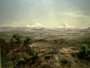
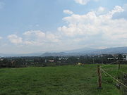
. Surrounded by mountains and volcanoes, the Valley of Mexico was a centre for several pre-Columbian
Pre-Columbian
The pre-Columbian era incorporates all period subdivisions in the history and prehistory of the Americas before the appearance of significant European influences on the American continents, spanning the time of the original settlement in the Upper Paleolithic period to European colonization during...
civilization
Civilization
Civilization is a sometimes controversial term that has been used in several related ways. Primarily, the term has been used to refer to the material and instrumental side of human cultures that are complex in terms of technology, science, and division of labor. Such civilizations are generally...
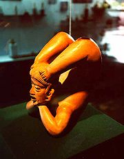
s, including Teotihuacan
Teotihuacan
Teotihuacan – also written Teotihuacán, with a Spanish orthographic accent on the last syllable – is an enormous archaeological site in the Basin of Mexico, just 30 miles northeast of Mexico City, containing some of the largest pyramidal structures built in the pre-Columbian Americas...
, the Toltec
Toltec
The Toltec culture is an archaeological Mesoamerican culture that dominated a state centered in Tula, Hidalgo in the early post-classic period of Mesoamerican chronology...
, and the Aztec
Aztec
The Aztec people were certain ethnic groups of central Mexico, particularly those groups who spoke the Nahuatl language and who dominated large parts of Mesoamerica in the 14th, 15th and 16th centuries, a period referred to as the late post-classic period in Mesoamerican chronology.Aztec is the...
. The ancient Aztec term Anahuac
Anahuac
Anahuac is an ancient name for a Mesoamerican, particularly Aztec, area or areas, usually identified as located within or even coterminous with the Valley of Mexico...
(Land Between the Waters) and the phrase Basin of Mexico are both used at times to refer to the Valley of Mexico. The Basin of Mexico became a well known site that epitomized the scene of early Classic Mesoamerican cultural development as well.
The Valley of Mexico is located in the Trans-Mexican Volcanic Belt
Trans-Mexican volcanic belt
The Trans-Mexican Volcanic Belt also known as the Transvolcanic Belt and locally as the Sierra Nevada , is a volcanic belt that extends 900 km from west to east across central-southern Mexico...
.
The valley contains most of the Mexico City Metropolitan Area
Greater Mexico City
Greater Mexico City refers to the conurbation around Mexico City, officially called Mexico City Metropolitan Area , constituted by the Federal District—itself composed of 16 boroughs—and 41 adjacent municipalities of the states of Mexico and Hidalgo...
, as well as parts of the State of Mexico, Hidalgo, Tlaxcala
Tlaxcala
Tlaxcala officially Estado Libre y Soberano de Tlaxcala is one of the 31 states which along with the Federal District comprise the 32 federative entities of Mexico. It is divided into 60 municipalities and its capital city is Tlaxcala....
and Puebla
Puebla
Puebla officially Estado Libre y Soberano de Puebla is one of the 31 states which, with the Federal District, comprise the 32 Federal Entities of Mexico. It is divided in 217 municipalities and its capital city is Puebla....
. The Valley of Mexico can be subdivided into four basins, but the largest and most-studied is the area which contains Mexico City
Mexico City
Mexico City is the Federal District , capital of Mexico and seat of the federal powers of the Mexican Union. It is a federal entity within Mexico which is not part of any one of the 31 Mexican states but belongs to the federation as a whole...
. This section of the valley in particular is colloquially referred to as the "Valley of Mexico".
The valley has a minimum altitude of 2200 metres (7,217.8 ft) above sea level
Above mean sea level
The term above mean sea level refers to the elevation or altitude of any object, relative to the average sea level datum. AMSL is used extensively in radio by engineers to determine the coverage area a station will be able to reach...
and is surrounded by mountains and volcanoes that reach elevations of over 5000 metres (16,404.2 ft). It is an enclosed valley with no natural outlet for water to flow and a gap to the north where there is a high mesa
Mesa
A mesa or table mountain is an elevated area of land with a flat top and sides that are usually steep cliffs. It takes its name from its characteristic table-top shape....
but no high mountain peaks. Hydrologically, the valley has three features. The first feature is the lakebeds of five now-extinct lakes, which are located in the southernmost and largest of the four sub-basins. The other two features are piedmont
Foothills
Foothills are geographically defined as gradual increases in elevation at the base of a mountain range. They are a transition zone between plains and low relief hills to the adjacent topographically high mountains.-Examples:...
, and the mountainsides that collect the precipitation that eventually flows to the lake area. These last two are found in all four of the sub-basins of the valley. Seismic activity is frequent here, and the valley is considered an earthquake prone zone.
The valley has been inhabited for at least 12,000 years, attracting humans with its mild climate (average temperatures between 12 and 15 °C, or 54 and 59 °F), abundant game and ability to support large-scale agriculture. Civilizations that have arisen in this area include the Teotihuacan
Teotihuacan
Teotihuacan – also written Teotihuacán, with a Spanish orthographic accent on the last syllable – is an enormous archaeological site in the Basin of Mexico, just 30 miles northeast of Mexico City, containing some of the largest pyramidal structures built in the pre-Columbian Americas...
(800 BCE to 800 CE), the Toltec
Toltec
The Toltec culture is an archaeological Mesoamerican culture that dominated a state centered in Tula, Hidalgo in the early post-classic period of Mesoamerican chronology...
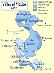
Empire (10th to 13th century) and the Aztec Empire (1325 to 1521). When the Spaniards arrived in the Valley of Mexico, it had one of the highest population concentrations in the world with about one million people. After the Conquest, the Spaniards rebuilt the largest and most dominant city here, Tenochtitlan, renaming it Mexico City. The valley used to contain five lakes called Lake Zumpango, Lake Xaltoca, Lake Xochimilco, Lake Chalco, and the largest, Texcoco
Lake Texcoco
Lake Texcoco was a natural lake formation within the Valley of Mexico. The Aztecs built the city of Tenochtitlan on an island in the lake. The Spaniards built Mexico City over Tenochtitlan...
covering about 1500 square kilometres (579.2 sq mi) of the valley floor, but as the Spaniards expanded Mexico City, they began to drain the lakes' waters to control flooding. Although violence and disease significantly lowered the population of the valley after the Conquest, by 1900 it was again over one million people. The 20th and 21st centuries have seen an explosion of population in the valley along with the growth of industry. Since 1900, the population has doubled every fifteen years. Today, around 21 million people live in the Mexico City Metropolitan Area which extends throughout almost all of the valley into the states of Mexico and Hidalgo.
The growth of a major urban, industrial centre in an enclosed basin has created significant air and water quality issues for the valley. Wind patterns and thermal inversions trap contaminants in the valley. Over-extraction of ground water has caused new flooding problems for the city as it sinks below the historic lake floor. This causes stress on the valley's drainage system, requiring new tunnels and canals to be built.
First human habitation
The Valley of Mexico attracted early humans because the region was rich in biodiversity and had the capacity of growing substantial crops. Generally speaking, humans in MesoamericaMesoamerica
Mesoamerica is a region and culture area in the Americas, extending approximately from central Mexico to Belize, Guatemala, El Salvador, Honduras, Nicaragua, and Costa Rica, within which a number of pre-Columbian societies flourished before the Spanish colonization of the Americas in the 15th and...
, including central Mexico, began to leave a hunter-gatherer existence in favor of agriculture sometime between the end of the Pleistocene
Pleistocene
The Pleistocene is the epoch from 2,588,000 to 11,700 years BP that spans the world's recent period of repeated glaciations. The name pleistocene is derived from the Greek and ....
epoch
Geologic time scale
The geologic time scale provides a system of chronologic measurement relating stratigraphy to time that is used by geologists, paleontologists and other earth scientists to describe the timing and relationships between events that have occurred during the history of the Earth...
and the beginning of the Holocene
Holocene
The Holocene is a geological epoch which began at the end of the Pleistocene and continues to the present. The Holocene is part of the Quaternary period. Its name comes from the Greek words and , meaning "entirely recent"...
. The oldest known human settlement in the Valley of Mexico is located in Tlapacoya, located on what was the edge of Lake Chalco in the southeast corner of the valley in contemporary Mexico State. There is reliable archeological evidence to suggest that the site dates as far back as 12,000 BCE. After 10,000 BCE, the number of artifacts found increases significantly. There are also other early sites such as those in Tepexpan, Los Reyes Acozac, San Bartolo Atepehuacan, Chimalhuacán and Los Reyes La Paz
Los Reyes Acaquilpan
Los Reyes Acaquilpan is a city and governing head of the municipality of La Paz in Mexico State, Mexico. It is located on the dividing line between Mexico State and the eastern edge of the Federal District. It can therefore be considered part of the Greater Mexico City area...
but they remain undated. Human remains and artifacts such as obsidian blades have been found at the Tlapacoya site that have been dated as far back as 20,000 BCE, when the valley was semi-arid and contained species like camel
Camel
A camel is an even-toed ungulate within the genus Camelus, bearing distinctive fatty deposits known as humps on its back. There are two species of camels: the dromedary or Arabian camel has a single hump, and the bactrian has two humps. Dromedaries are native to the dry desert areas of West Asia,...
s, bison
Bison
Members of the genus Bison are large, even-toed ungulates within the subfamily Bovinae. Two extant and four extinct species are recognized...
and horses that could be hunted by man. However, the precise dating of these artifacts has been disputed.
Mammoth
A mammoth is any species of the extinct genus Mammuthus. These proboscideans are members of Elephantidae, the family of elephants and mammoths, and close relatives of modern elephants. They were often equipped with long curved tusks and, in northern species, a covering of long hair...
s once populated the area, and the valley contains the most extensive mammoth kill sites in Mexico. Most of the sites are located on what were the shores of Lake Texcoco in the north of the Federal District and the adjacent municipalities of Mexico State such as in Santa Isabel Ixtapan
Santa Isabel Ixtapan
Santa Isabel Ixtapan is a community which is part of the municipality of San Salvador Atenco in the State of Mexico, Mexico. It has 4,125 inhabitants and lies 2,240 meters above sea level....
, Los Reyes Acozac
Los Reyes Acozac
Los Reyes Acozac is a community that belongs to the municipality of Tecámac in the State of Mexico in Mexico. It has a population of 20,478 inhabitants and is located at an altitude of 2,250 meters above sea level. The area is known for significant deposits of mammoth bones.-References:...
, Tepexpan
Tepexpan
Tepexpan is the largest town in the Acolman municipality in Mexico State, Mexico. The population was 48,103 as of the 2005 Mexican census.One of the most interesting aspects of this town is the discovery of an early Mesoamerican skeleton commonly referred to as "Tepexpan man". Recent research tries...
and Tlanepantla
Tlalnepantla de Baz
Tlalnepantla de Baz is a city and a municipality of the State of Mexico in the north of Mexico City . Tlalnepantla comes from the Náhuatl words tlalli and nepantla to mean the middle land...
. Mammoth bones are still occasionally found in farmland here. They have been discovered in many parts of the Federal District itself, particularly during the construction of the city's Metro lines
Mexico City Metro
The Mexico City Metro , officially called Sistema de Transporte Colectivo, is a metro system that serves the metropolitan area of Mexico City...
and in the neighborhoods of Del Valle
Colonia del Valle
Colonia del Valle is a neighborhood in the Benito Juarez borough of Mexico City. The city includes "...a great number of parks, vast and tree-lined streets, prestigious shopping malls, and some city landmarks..."...
in the center, Lindavista to the center-north and Coyoacán
Coyoacán
Coyoacán refers to one of the sixteen boroughs of the Federal District of Mexico City as well as the former village which is now the borough’s “historic center.” The name comes from Nahuatl and most likely means “place of coyotes,” when the Aztecs named a pre-Hispanic village on the southern shore...
in the south of the city. The symbol for Line 4 of the Mexico City Metro is a mammoth, due to the fact that so many bones were uncovered during its construction. However, the richest site for mammoth remains in the valley is at the Paleontological Museum in Tocuila
Paleontological Museum in Tocuila
The Paleontological Museum in Tocuila displays part of one of the richest deposits of Late Pleistocene fauna in America...
, a 45 hectares (111.2 acre) site located near the town of Texcoco
Texcoco, Mexico State
Texcoco is a city and municipality located in the northeast portion of Mexico State, 25 km northeast of Mexico City. In the pre-Hispanic era, this was a major Aztec city on the shores of Lake Texcoco. After the Conquest, the city was initially the second most important after Mexico City,...
in Mexico State. Although there is some evidence around the old lakeshores that the first populations here survived by hunting, gathering and possibly by scavenging, but evidence from this time period is scarce.
Pre-Teotihuacan
Tlatilco
Tlatilco was a large pre-Columbian village in the Valley of Mexico situated near the modern-day town of the same name in the Mexican Federal District. It was one of the first chiefdom centers to arise in the Valley, flourishing on the western shore of Lake Texcoco during the Middle Pre-Classic...
was a large pre-Columbian
Pre-Columbian
The pre-Columbian era incorporates all period subdivisions in the history and prehistory of the Americas before the appearance of significant European influences on the American continents, spanning the time of the original settlement in the Upper Paleolithic period to European colonization during...
village and culture in the Valley of Mexico situated near the modern-day town of the same name in the Mexican Federal District. It was one of the first significant population centers to arise in the valley, flourishing on the western shore of Lake Texcoco during the Middle Pre-Classic period
Mesoamerican chronology
Mesoamerican chronology divides the history of pre-Columbian Mesoamerica into several periods: the Paleo-Indian , the Archaic , the Preclassic , the Classic , and the Postclassic...
, between the years of 1200 BCE and 200 BCE. It was originally classified as a necropolis
Necropolis
A necropolis is a large cemetery or burial ground, usually including structural tombs. The word comes from the Greek νεκρόπολις - nekropolis, literally meaning "city of the dead"...
when it was first excavated, but it was determined that the many burials here were really under houses of which nothing remains. It was then classified as a major chiefdom center. The Tlatilcans were an agricultural people growing beans, amaranth
Amaranth
Amaranthus, collectively known as amaranth, is a cosmopolitan genus of herbs. Approximately 60 species are recognized, with inflorescences and foliage ranging from purple and red to gold...
, squash and chili pepper
Chili pepper
Chili pepper is the fruit of plants from the genus Capsicum, members of the nightshade family, Solanaceae. The term in British English and in Australia, New Zealand, India, Malaysia and other Asian countries is just chilli without pepper.Chili peppers originated in the Americas...
s, reaching its peak from 1000-700 BCE.
The next oldest confirmed civilization is in the far south of the valley and is called Cuicuilco
Cuicuilco
Cuicuilco is an important archaeological Mesoamerican Middle and Late Formative period site located on the southern shore of the Lake Texcoco in the southeastern Valley of Mexico. Today, it is a significant archaeological site that was occupied during the Early Formative until its destruction in...
. This archeological site is located where Avenida Insurgentes Sur
Avenida de los Insurgentes
Avenida de los Insurgentes , sometimes known simply as Insurgentes, is the longest avenue in Mexico City and said to be the longest in the world with a length of on a north-south axis across the city...
crosses the Anillo Periférico
Anillo Periférico
The Anillo Periférico is the name given to the outer beltway of Mexico City. The beltway gained major media attention when the Mexico City mayor, Andrés Manuel López Obrador, started a project to turn a southern section of the ring into a two-story highway...
in the Tlalpan
Tlalpan
Tlalpan is one of the sixteen administrative boroughs of the Federal District of Mexico City. It is the largest borough, with over eighty percent under conservation as forest and other ecologically sensitive area. The rest, almost all of it on the northern edge, has been urban since the mid 20th...
borough of the city. The old settlement once extended far beyond the boundaries of the current site, but it is buried under lava from one of the volcanic eruptions that led to its demise, and much of the modern city is built over this lava. The settlement was located where an old river delta used to form in the valley with waters from Mount Zacatépetl located in what is now the Tlalpan Forest. Cuicuilco was believed to have reach city status by 1200 BCE and began to decline around 100 BC-150 CE
Common Era
Common Era ,abbreviated as CE, is an alternative designation for the calendar era originally introduced by Dionysius Exiguus in the 6th century, traditionally identified with Anno Domini .Dates before the year 1 CE are indicated by the usage of BCE, short for Before the Common Era Common Era...
. However, even though the ceremonial pyramid was abandoned, the site remained a location to leave offerings up to 400 CE, despite the fact that lava from the nearby Xitle
Xitle
Xitle is a volcano in the Ajusco range in Cumbres del Ajusco National Park. It is located in the Tlalpan borough in the southwestern part of Mexico City. It is an ash cone volcano with a conical form, round base, altitude of approximately 300m, and a slope between 30° and 40°.Xitle registered its...
volcano completely covered it.
Teotihuacan and the Toltecs
Around 2,000 years ago, the Valley of Mexico became one of the world's most densely populated areas and has remained so since. After the decline of Cuiculco, the population concentration shifted north, to the city of Teotihuacan and later to TulaTula, Hidalgo
Tula, formally, Tula de Allende, is a town and one of the 84 municipalities of Hidalgo, in central-eastern Mexico. The municipality covers an area of 305.8 km² , and as of 2005, the municipality had a total population of 93,296, with 28,432 in the town...
, both outside the lake's region of the valley. Teotihuacan became an organized village around 800 BCE but it was around 200 BCE that it began to reach its height. When it did, the city had approximately 125,000 inhabitants and covered 20 square kilometres (8 sq mi) of territory. It was dedicated primarily to the obsidian
Obsidian
Obsidian is a naturally occurring volcanic glass formed as an extrusive igneous rock.It is produced when felsic lava extruded from a volcano cools rapidly with minimum crystal growth...
trade and at its peak was an important religious center and pilgrimage
Pilgrimage
A pilgrimage is a journey or search of great moral or spiritual significance. Typically, it is a journey to a shrine or other location of importance to a person's beliefs and faith...
for the valley. In the early 8th century, with the rise of the Toltec
Toltec
The Toltec culture is an archaeological Mesoamerican culture that dominated a state centered in Tula, Hidalgo in the early post-classic period of Mesoamerican chronology...
empire, Teotihuacan ceased to be a major urban centre and the population shifted to Tollan or Tula on the northern front of Valley of Mexico.
Aztec Empire
After the end of the Toltec empire in the 13th century and the decline of the city of Tula, the population shifted once again, this time to the lakes region of the valley. With this migration came the concept of a city-state based on the Toltec model. By the end of the 13th century, some fifty small urban units, semi-autonomous and with their own religious centers, had sprung up around the lakeshores of the valley. These remained intact with a population of about 10,000 each under Aztec rule and survived into the colonial period. All of these city-states, including the largest and most powerful, Tenochtitlan, with more than 150,000 inhabitants, claimed descent from the Toltecs. None of these cities was completely autonomous or self-sufficient, resulting in a conflictive political situation, and a complex system of agriculture in the valley. These city-states had similar governmental structures based on the need to control flooding and store water for irrigating crops. Many of the institutions created by these hydraulic societies, such as the building and maintenance of chinampas, aqueducts and dikes, were later co-opted by the Spanish during the colonial period.The largest and most dominant city at the time of the Spanish conquest was Tenochtitlan. It was founded on a small island in the western part of Lake Texcoco in 1325, and was extended with the use of chinampa
Chinampa
Chinampa is a method of ancient Mesoamerican agriculture which used small, rectangle-shaped areas of fertile arable land to grow crops on the shallow lake beds in the Valley of Mexico.-Description:...
s (often referred to as floating gardens), to fill in the shallow lake, covering about 9000 hectares (34.7 sq mi). The inhabitants controlled the lake with a sophisticated system of dikes, canals and sluice
Sluice
A sluice is a water channel that is controlled at its head by a gate . For example, a millrace is a sluice that channels water toward a water mill...
s. Much of the surrounding land in the valley was terraced and farmed
Terrace (agriculture)
Terraces are used in farming to cultivate sloped land. Graduated terrace steps are commonly used to farm on hilly or mountainous terrain. Terraced fields decrease erosion and surface runoff, and are effective for growing crops requiring much water, such as rice...
as well, with a network of aqueduct
Aqueduct
An aqueduct is a water supply or navigable channel constructed to convey water. In modern engineering, the term is used for any system of pipes, ditches, canals, tunnels, and other structures used for this purpose....
s channeling fresh water from springs in the mountainsides into the city itself. Despite being the dominant power, the need to rely on resources from other parts of the valley led to the Aztec Triple Alliance
Aztec Triple Alliance
The Aztec Triple Alliance, or Aztec Empire began as an alliance of three Nahua city-states or "altepeme": Tenochtitlan, Texcoco, and Tlacopan...
between Tenochtitlan, Texcoco and Tlacopan
Tlacopan
Tlacopan , also called Tacuba, was a Pre-Columbian Mesoamerican city-state situated on the western shore of Lake Texcoco.Founded by Tlacomatzin, Tlacopan was a Tepanec kingdom subordinate to nearby Azcapotzalco...
at the beginning of the empire. However, by the time the Spanish arrived, Tenochtitlan had suppressed the other two allies, causing grievances that the Spaniards were able to exploit. However, despite Tenochtitlan's power outside the valley, it never completely controlled all of the valley itself. The Spanish would change this status in the colonial period.
By 1520, the estimated population of the valley was over 1,000,000 people.
Spanish colonial rule and the Mexico City metropolitan area
After the Conquest, the Spanish rebuilt and renamed the city. They started with essentially the same size and layout as the Aztec city but as the centuries progressed, the city grew as the lakes shrank. Just after the Conquest, disease and violence had decreased the population in the valley, especially of the native peoples, but after that, the population grew all through the colonial period and the 1st century after independenceMexican War of Independence
The Mexican War of Independence was an armed conflict between the people of Mexico and the Spanish colonial authorities which started on 16 September 1810. The movement, which became known as the Mexican War of Independence, was led by Mexican-born Spaniards, Mestizos and Amerindians who sought...
. By the early 20th century, the population of Mexico City alone had risen to over one million people. A population explosion began early in the 20th century, with the population of the city itself doubling approximately every 15 years since 1900, partly attributed to the fact that the federal government has favored development of the metropolitan area over other areas of the country. This has spurred investment in infrastructure
Infrastructure
Infrastructure is basic physical and organizational structures needed for the operation of a society or enterprise, or the services and facilities necessary for an economy to function...
for the city, such as electricity
Electricity
Electricity is a general term encompassing a variety of phenomena resulting from the presence and flow of electric charge. These include many easily recognizable phenomena, such as lightning, static electricity, and the flow of electrical current in an electrical wire...
, other power sources, water supply
Water supply
Water supply is the provision of water by public utilities, commercial organisations, community endeavours or by individuals, usually via a system of pumps and pipes...
and drainage
Drainage
Drainage is the natural or artificial removal of surface and sub-surface water from an area. Many agricultural soils need drainage to improve production or to manage water supplies.-Early history:...
. These have attracted businesses which in turn have attracted more population. Since the 1950s, urbanization has spread out from beyond the bounds of the Federal District to the surrounding jurisdictions, especially to the north into the State of Mexico making for the Mexico City Metropolitan area, which fills most of the valley. Today, this metropolitan area accounts for 45 per cent of the country's industrial activity, 38 percent of GNP, and 25 percent of the population. Much of its industry is concentrated in the northern part of the Federal District and the adjoining cities in the state of Mexico. While population growth has slowed and even declined in the city proper, the outer limits of the metropolitan area keep growing. Much of this growth has occurred on the mountainsides of the valley, in the form of illegal settlements in ecologically-sensitive areas. Overall urban settlement in the valley has expanded from about 90 km² (34.7 sq mi) in 1940 to 1160 km² (447.9 sq mi) in 1990. The metropolitan area has about 21 million residents and about 6 million cars.
Air pollution
Mexico City is vulnerable to severe air pollution problems due to its altitude, its being surrounded by mountains and the winds patterns of the area. The altitude, with its low oxygen levels makes for poor combustion of fossil fuelFossil fuel
Fossil fuels are fuels formed by natural processes such as anaerobic decomposition of buried dead organisms. The age of the organisms and their resulting fossil fuels is typically millions of years, and sometimes exceeds 650 million years...
s leading to unsafe levels of nitrogen oxide
Nitrogen oxide
Nitrogen oxide can refer to a binary compound of oxygen and nitrogen, or a mixture of such compounds:* Nitric oxide, also known as nitrogen monoxide, , nitrogen oxide* Nitrogen dioxide , nitrogen oxide...
s, hydrocarbons, and carbon monoxide
Carbon monoxide
Carbon monoxide , also called carbonous oxide, is a colorless, odorless, and tasteless gas that is slightly lighter than air. It is highly toxic to humans and animals in higher quantities, although it is also produced in normal animal metabolism in low quantities, and is thought to have some normal...
. The valley is surrounded by mountain ranges with one small opening to the north. The surrounding mountains and climate patterns here make it difficult to clear out the smog produced. The valley has internal wind patterns with circulate around the valley without a prevailing wind to push contaminants in a single direction. The most significant climatic phenomena here is "thermal inversion," which is prevalent in the winter months when the cooler air of the valley is trapped by relatively warmer air above. Adding to this is that prevailing winds outside the valley move from north to south, in through the Valley's one opening, where incidentally most of the region's industry is located. These factors diminish in the summer and the situation is helped by the arrival of the rainy season, but the valley's southern latitude and the abundance of sunlight allows for dangerous levels of ozone
Ozone
Ozone , or trioxygen, is a triatomic molecule, consisting of three oxygen atoms. It is an allotrope of oxygen that is much less stable than the diatomic allotrope...
and other dangerous compounds.
Lead
Lead is a main-group element in the carbon group with the symbol Pb and atomic number 82. Lead is a soft, malleable poor metal. It is also counted as one of the heavy metals. Metallic lead has a bluish-white color after being freshly cut, but it soon tarnishes to a dull grayish color when exposed...
contamination in the air with the introduction of unleaded gasoline
Gasoline
Gasoline , or petrol , is a toxic, translucent, petroleum-derived liquid that is primarily used as a fuel in internal combustion engines. It consists mostly of organic compounds obtained by the fractional distillation of petroleum, enhanced with a variety of additives. Some gasolines also contain...
. Two other contaminants that have been brought under control are carbon monoxide and sulfur dioxide
Sulfur dioxide
Sulfur dioxide is the chemical compound with the formula . It is released by volcanoes and in various industrial processes. Since coal and petroleum often contain sulfur compounds, their combustion generates sulfur dioxide unless the sulfur compounds are removed before burning the fuel...
. The contamination problems that remain are primarily with ozone and fine particles (soot
Soot
Soot is a general term that refers to impure carbon particles resulting from the incomplete combustion of a hydrocarbon. It is more properly restricted to the product of the gas-phase combustion process but is commonly extended to include the residual pyrolyzed fuel particles such as cenospheres,...
) (between 2.5 micrometers and 10 micrometers). Thirty to fifty percent of the time, Mexico City's levels of fine particles of ten micrometers, the most dangerous, exceed levels recommended by the World Health Organization
World Health Organization
The World Health Organization is a specialized agency of the United Nations that acts as a coordinating authority on international public health. Established on 7 April 1948, with headquarters in Geneva, Switzerland, the agency inherited the mandate and resources of its predecessor, the Health...
.
In the 1940s, before large-scale burning of fossil fuels in the area, the visibility of the valley was about 100 kilometre, allowing for daily viewing of the mountain ranges that surround the valley, including the snow-capped volcanoes of Popocatepetl and Iztaccihuatl. Since that time, the average visibility has come down to about 1.5 km (4,921.3 ft). Mountain peaks are now rarely visible from the city itself. While reduced visibility in the valley was due to sulfur emissions in the past, it is now due to fine particles in the air.
The effects on humans living in an enclosed, contaminated environment have been documented, especially by Nobel Prize
Nobel Prize
The Nobel Prizes are annual international awards bestowed by Scandinavian committees in recognition of cultural and scientific advances. The will of the Swedish chemist Alfred Nobel, the inventor of dynamite, established the prizes in 1895...
winner Dr Mario J. Molina
Mario J. Molina
Mario José Molina-Pasquel Henríquez is a Mexican chemist and one of the most prominent precursors to the discovering of the Antarctic ozone hole. He was a co-recipient Mario José Molina-Pasquel Henríquez (born March 19, 1943 in Mexico City) is a Mexican chemist and one of the most prominent...
. He claims fine particle pollution is the greatest concern because of lung damage. According to him, the city's residents lose about 2.5 million working days every year due to health problems associated with fine particles.
Hydrology
The Valley of Mexico is a closed basin which geologically divides into three hydrologic zones, the low plain, which is essentially the bed of now-extinct lakes, the piedmont area and the surrounding mountains. The old lakebeds correspond to the lowest elevations of the valley in the south are mostly clay with a high water content and are almost entirely covered by urban development. In the piedmont area, these clays become mixed with silts and sands, and in some areas close to the mountains, the piedmont is largely composed of basaltBasalt
Basalt is a common extrusive volcanic rock. It is usually grey to black and fine-grained due to rapid cooling of lava at the surface of a planet. It may be porphyritic containing larger crystals in a fine matrix, or vesicular, or frothy scoria. Unweathered basalt is black or grey...
from old lava flows. The valley is enclosed completely by mountain ranges, from which flow rain and melting snow into the valley's hydraulic system. This groundwater flow produces a number of springs
Spring (hydrosphere)
A spring—also known as a rising or resurgence—is a component of the hydrosphere. Specifically, it is any natural situation where water flows to the surface of the earth from underground...
in the foothills and upwelling
Upwelling
Upwelling is an oceanographic phenomenon that involves wind-driven motion of dense, cooler, and usually nutrient-rich water towards the ocean surface, replacing the warmer, usually nutrient-depleted surface water. The increased availability in upwelling regions results in high levels of primary...
s in the valley floor. This underground flow is the source of the five aquifers that provide much of the drinking water to Mexico City located in Soltepec, Apan, Texcoco
Texcoco, Mexico State
Texcoco is a city and municipality located in the northeast portion of Mexico State, 25 km northeast of Mexico City. In the pre-Hispanic era, this was a major Aztec city on the shores of Lake Texcoco. After the Conquest, the city was initially the second most important after Mexico City,...
, Chalco-Amecameca
Amecameca
Amecameca is a town and municipality located in the eastern panhandle of Mexico State between Mexico City and the Iztaccíhuatl and Popocatépetl volcanos of the Sierra Nevada mountain range. It is located on federal highway 115 which leads to Cuautla, which is called the Volcano Route...
and underneath Mexico City itself.
Old lake system
Long before the arrival of the Spanish, the lake system had been shrinking due to climate change. Warmer temperatures had increased evaporation and reduced rainfall in the area so that the lakes’ waters were shallow at about five meters (16 ft) deep as early as the Tlapacoya
Tlapacoya (Mesoamerican site)
Tlapacoya is an important archaeological site in Mexico, located at the foot of the Tlapacoya volcano, southeast of Mexico City, on the former shore of Lake Chalco. Tlapacoya was a major site for the Tlatilco culture....
culture, around 10,000 BCE. During the Aztec Empire, the northern lakes were inaccessible by canoe during the dry season from October to May.
The arrival of the Spanish and subsequent efforts to drain the area for flood control, along with the over-pumping of groundwater has hastened the disappearance of the lakes. The old lakebeds are almost all paved except for some canals preserved in Xochimilco, mostly for the benefit of visitors who tour them on brightly-painted trajineras, boats similar to gondola
Gondola
The gondola is a traditional, flat-bottomed Venetian rowing boat, well suited to the conditions of the Venetian Lagoon. For centuries gondolas were the chief means of transportation and most common watercraft within Venice. In modern times the iconic boats still have a role in public transport in...
s.
History of water control in the valley
For two thousand years, humans have been interfering with and altering the hydraulic conditions of the valley, especially in the lakes region. The Aztecs built dikes for flood control and to separate the fresh water of the northern lakes from the saline waterSaline water
Saline water is a general term for water that contains a significant concentration of dissolved salts . The concentration is usually expressed in parts per million of salt....
of the southern ones. After the destruction of Tenochtitlan in 1521, the Spaniards rebuilt the Aztec dikes but found they did not offer enough flood protection.
The idea of opening drainage canals first came about after a flood of the colonial city in 1555. The first canal was begun in 1605 to drain the waters of Lake Zumpango north through Huehuetoca
Huehuetoca
Huehuetoca is a municipio in Mexico State, central Mexico, and also the name of its largest locality and municipal seat.-Name origins:...
which would also divert waters from the Cuautitlán River away from the lakes and toward the Tula River
Tula River
Rio Tula is a river in Hidalgo state in central Mexico. It runs through the ancient town of Tula....
. This project was undertaken by Enrico Martínez
Enrico Martínez
Enrico Martínez , Henri Martín or Heinrich Martin, was cosmographer to the King of Spain, interpreter for the Spanish Inquisition, publisher, and hydraulic engineer....
and he devoted 25 years of his life to it. He did succeed in building a canal in this area, calling it Nochistongo, leading waters to the Tula Valley, but the drainage was not sufficient to avoid the Great Flood of 1629 in the city. Another canal, which would be dubbed the "Grand Canal" was built parallel to the Nochistongo one ending in Tequixquiac
Tequixquiac
Santiago Tequixquiac is the seat of the municipality of Tequixquiac located in the northeastern part of the state of Mexico in Mexico, although both are commonly called Tequixquiac. The town is located at a northern pass leading out of the Valley of Mexico and about 120 km northeast of the...
. The Grand Canal consists of one main canal, which measures 6.5 metres (21 ft) in diameter and 50 kilometre long, and three secondary canals, with most of it built between 1856 and 1867. Porfirio Díaz
Porfirio Díaz
José de la Cruz Porfirio Díaz Mori was a Mexican-American War volunteer and French intervention hero, an accomplished general and the President of Mexico continuously from 1876 to 1911, with the exception of a brief term in 1876 when he left Juan N...
completed all of it officially in 1894 although work continued thereafter. Despite the Grand Canal's drainage capacity, it did not solve the problem of flooding in the city. From the beginning of the 20th century, Mexico City began to sink rapidly and pumps needed to be installed in the Grand Canal, which before had drained the valley purely with gravity. Along with the pumps, the Grand Canal was expanded with a new tunnel through the low mountains called the Xalpa to take the canal past Tequisquiac. Even so, the city still suffered floods in 1950 and 1951. Despite its age, the Grand Canal can still carry 2400000 USgal/min out of the valley, but this is significantly less than what it could carry as late as 1975 because continued sinking of the city (as much as seven meters) weakens the system of water collectors and pumps.
As a result, another tunnel, called the Emisor Central, was built to carry wastewater. Although it is considered the most important pipe in the country, it has been damaged by overwork and corrosion of its 20 ft (6 m) diameter walls. Because of lack of maintenance and gradual decrease in this tunnel's ability to carry water, there is concern that this tunnel will soon fail. It is continuously filled with water, making it impossible to inspect it for problems. If it fails, it would most likely be during the rainy season when it carries the most water, which would cause extensive flooding in the historic center, the airport and the boroughs on the east side.
Because of this, another new drainage project is planned that will cost $1.3 billion USD. The project includes new pumping stations, a new 30 mile drainage tunnel and repairs to the current 7400 mile system of pipes and tunnels to clear blockages and patch leaks.
Drinking water and sinking
Historically, Mexico City's potable water supply came via aqueduct from the mountain springs on the valley sides like that in Chapultepec as most of the water in Lake Texcoco was saline. These were originally built by the Aztecs and were rebuilt by the Spaniards. In the mid-1850s, potable groundwater was found underneath the city itself, which motivated the large-scale drilling of wells. Today 70% of Mexico City's water still comes from five principle aquifers in the valley. These aquifers are fed by water from natural springs and runoff from precipitation. Only about thirty five years ago did Mexico City have problems supplying water to its population, when such was about six million, forcing it to appropriate water from outside the valley.
Today, Mexico City faces a serious water deficit. Because of increased demand of a growing population and industry as well as ecosystem degradation in the form of deforestation of the surrounding mountains, more water is leaving the system than is entering. It is estimated that 63 m3/s of water is needed to support the potable and agricultural irrigation needs of Mexico City's population. The main aquifer is being pumped at a rate of 55.5 m3/s, but is only being replaced at 28 m3/s, or about half of the extraction rate, leaving a shortfall of 27.5 m3/s.
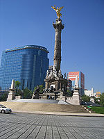
This over-extraction of groundwater from the old clay lake bed has been causing the land upon which the city rests to collapse and sink. This problem began in the early 20th century as a consequence of the drainage of the valley for flood control. Since the beginning of the 20th century, some areas of Mexico City have sunk nine meters (30 ft). In 1900, the bottom of the lake was three meters (10 ft) lower than the median level of the city center. By 1974, the lake bottom was two meters (7 ft) higher than the city. The first signs of dropping ground water levels was the drying up of natural springs in the 1930s, which coincides with the beginning of intensive exploitation of the aquifer system through wells between 100 metre deep. Today, Mexico City is sinking between five and forty centimeters (0.2 and 1.3 ft) per year, and its effects are visible. El Ángel de la Independencia ("The Angel of Independence") statue, located on Paseo de la Reforma
Paseo de la Reforma
Paseo de la Reforma is a wide avenue that runs in a straight line, cutting diagonally across Mexico City. It was designed by Ferdinand von Rosenzweig in the 1860s and modeled after the great boulevards of Europe, such as Vienna's Ringstrasse or the Champs-Élysées in Paris...
was built in 1910, anchored by a foundation deep beneath what was the surface of the street at that time. However, because the street has sunk around it, steps have been added to allow access to the statue's base.
Subsidence of the valley floor beneath has caused flooding problems as now much of the city has sunk below the natural lake floor. Currently, pumps need to work 24 hours a day all year round to keep control of runoff and wastewater. Despite this, flooding is still common, especially in the summer rainy season, in lower-lying neighborhoods such as Iztapalapa, forcing residents to build miniature dikes in front of their houses to prevent heavily polluted rainwater from entering their homes. Subsidence also causes damage to water and sewer lines, leaving the water distribution system vulnerable to contamination which carries risks to public health.
Measures other than drainage have been implemented to contain flooding in the city. In 1950, dikes were built to confine storm runoff. Rivers that run through the city were encapsulated in 1950 and 1951. Rivers such as the Consulado River, Churubusco River and the Remedio River are encased in concrete tunnels which take their waters directly to the drainage system to leave the Valley. Two other rivers, the San Javier and the Tlalnepantla, which used to feed the old lake system, are diverted before they reach the city and their waters now flow directly into the Grand Canal. None of water from these rivers is allowed to sink into the ground to recharge the aquifer. While the rivers and streams that flow down from the mountain peaks still begin the way they always have, their passage through the shantytowns that surround Mexico City turns them into sewer lines for these neighborhoods with no city services. Therefore, the goal is to keep this water from contaminating the aquifer.