

Selva Zoque
Encyclopedia
The Selva Zoque which includes the Chimalapas rain forest, is an area of great ecological importance in Mexico
. Most of the forest lies in the state of Oaxaca
but parts are in Chiapas
and Veracruz
.
It is the largest tract of tropical rainforest
in Mexico, and contains the majority of terrestrial biodiversity in the country.
The forest includes the Selva El Ocote, a federally protected biosphere reserve
, but is otherwise not yet protected.
Despite the rich ecology of the region, a 2003 study that focused on bird populations stated that "the fauna of the heart of the Chimalapas, including its vast rainforests, have seen little or no study".
As it is an impoverished region, efforts to preserve the ecology are often at odds with demands to improve the economy.
.
The terrain is rugged and includes a complex mixture of forest types at different levels.
Geologically, the region dates from the Upper Cretaceous and the Cenozoic
.
Elevations range from 100m to 2,700m.
Average monthly temperatures in most areas range between 18°C and 22°C, and annual rainfall between 500 and 2,500 mm, with high humidity throughout most of the region although there are dry interior valleys.
In some of the higher areas, mean annual temperatures are as low as 13°C.
Excluding the Uxpanapa
and La Sepultura extensions, the forest region covers about one million hectares.
The main Chimalapas region in Oaxaca covers approximately 600,000 hectares.
The forest contains the headwaters of five hydrological systems: the El Corte River
watershed, the Negro River watershed, which feeds the Nezahualcoyotl (Malpaso) Dam, the Uxpanapa River
watershed and the Coatzacoalcos River
which flow into Veracruz's southern wetlands and the Gulf of Mexico; and the Espiritu Santo River watershed which supplies the lagoon system to the south in the Pacific Ocean.
For example, over 300 orchid species have been identified, 60% of all orchid genera in Mexico.
Over 200 canopy tree species have been found in the Uxpanapa lowlands, and the entire region is estimated to have 3,500 vascular plant species.
Several genera and one family are only found in this area of Mexico.
Valuable plants include the tropical red cedar and bigleaf mahogany.
Palmita is an important source of revenue for the local people, with the ornamental leaves harvested carefully to avoid killing the plant.
Types of vegetation cover include:
 The forest forms a vital biological corridor between North and Central America and has very diverse zoology, lying at the conjunction between the Nearctic
and Neotropic ecozone
s and spanning a range of montane and lowland habitats.
It is home to species that include ocelot, tapir, and puma.
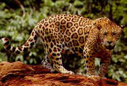
Highly threatened species include Jaguar
, Spider monkey
, White-lipped peccary
, Horned guan
, Quetzal
and Harpy Eagle.
There are estimated to be more than 600 birds species, including Great Curassow
, Crested Guan
and Ornate Hawk-Eagle.
Recent herpetological studies have found many new forms, including at least eight endemic reptile and amphibian species.
people believed to be descendants of the Olmec
.
With the arrival of the Spanish, the Uxpanapa
colony to the north established settlements on the Corte River (Cut River), which is easily navigable, and began to exploit the forest.
From 1731 to 1747, the region around Santa María Chimalapa
was an important source of giant pines, used for masts and beams by the Spanish navy. The trees were floated down the Corte River, which owes its name to the cutting of these trees, to Coatzacoalcos
and carried across to the Havana shipyards.
Despite continued contacts with the colonialists and prospectors, in their relatively inaccessible terrain the Chimas in the forest region were largely undisturbed until the later half of the nineteenth century, when the government started selling off concessions to exploit their "vacant" lands for timber and grazing.
The process slowed with the revolution of 1910, then picked up speed in the 1970s with fresh immigrants moving into the region, often assisted by the government.
In the early 1970s the federal government launched a program in the Uxpanapa region to resettle small farmers displaced by the Cerro de Oro Dam
, bulldozing and burning large areas of the forest to open it up for farming.
Approximately 26,000 people, mostly Chinantec
, were moved into the area.
The planned large scale agricultural schemes failed, although small farmers were able to make a living.
The displaced people were dissatisfied with the new conditions and protested, but did not achieve much. Several of their leaders were jailed.
Migrants also settled in other parts of the Selva Zoque.
Some of the new arrivals engaged in small scale farming and hunting, while others moved into more destructive activities such as ranching, illegal logging of valuable tree species and cultivation of narcotics.
In the core Chimalapas region there was a total population of about 18,000 in 1999. Two towns, Santa Maria Chimalapa and San Miguel Chimalapa
had a combined population of 3,000. The remainder was split between 38 "recognized" settlements and 34 informal settlements along the river banks and in the valleys. Some of the informal settlements were created by official colonization schemes and others by invading peasants.
The area is now ethnically diverse, with the Zoques reduced to a minority of perhaps 30%.
The region is extremely poor, with limited infrastructure such as roads and schools.
on the Pacific coast. Other plans include creating coffee plantations and cattle corridors, expanding production of beans, maize and chili and exploiting the bio-genetic resources of native medicinal plants.
A plan first proposed in 1977 for a dam in the Chimalapas has been stalled due to environmental concerns.
In June 2008 the State of Oaxaca was again proposing construction of a storage dam in the Rio El Corte Basin in the Chimalapa sub-region, with the potential to irrigate 100,000 hectares of the Isthmus of Tehuantepec and to supply water to the Salina Cruz Refinery.
To reduce impact of this nearby development on the Chimalapas the government has in the past made offers to buy forest land and turn it into a biosphere reserve, but these have been rejected by the native people who would lose their ancestral lands.
More recently, plans (at least in Oaxaca) have involved the communities affected and have emphasized sustainable use of the forest resources.
This approach appears to have more promise.
 Environmental issues include destructive forestry, land clearance for grazing livestock and clearance for cultivation of illegal drugs. Rare animal species are at risk from illegal hunting, and valuable trees such as mahogany and cedar are extracted through illegal forestry. Construction of Federal roads may cause loss of continuity between the different forest areas. In the Uxpanapa area more than 80% of the original cover has been lost, and in the Ocote area 40%. Loss of original cover has been relatively low in Los Chimalapas area.
At the end of the dry season in early 1998 there were extensive forest fires in the region, affecting over 200,000 hectares.
The season had been exceptionally dry, partly due to El Niño.
When the rains came, flooding resulted and since then land productivity has fallen. Various theories were put forward to explain the fires, ranging from slash and burn clearing within the forest and deliberate burns to remove stubble from farmland that ran out of control to a plot by the government to create the fires from the air. Some pointed out that much of the burned land was in the area that would be covered by the proposed dam and highway.
The implication that fires were set deliberately is based on the belief that there are powerful interests who would like to see the region exploited for its lumber and farmland potential, and to see the large hydropower potential put to work.
The forest has been designated "outstanding at a bioregional level" by the World Bank
and the World Wide Fund for Nature
(WWF), and has been recognized as a Global 200
ecoregion.
The government has recognized the rights of the communities in Chimalapas to be involved in conservation planning.
The Maderas rainforest conservancy
has been active in the area, seeking to prevent further fires and encourage sustainable land use.
The WWF has also been active in attempting to encourage conservation efforts in the Chimalapas area.
The El Ocote area is now protected, although with mixed results. Pronatura
Chiapas and Pronatura Veracruz are also working on conservation projects in the area.
The goal is to improve environmental protection while supporting sustainable use of the natural resources by the local population.
However, it is difficult to strike a balance between protecting this unique environment, respecting the rights of the traditional inhabitants and improving the economy to eliminate poverty, malnutrition and disease.
Mexico
The United Mexican States , commonly known as Mexico , is a federal constitutional republic in North America. It is bordered on the north by the United States; on the south and west by the Pacific Ocean; on the southeast by Guatemala, Belize, and the Caribbean Sea; and on the east by the Gulf of...
. Most of the forest lies in the state of Oaxaca
Oaxaca
Oaxaca , , officially Estado Libre y Soberano de Oaxaca is one of the 31 states which, along with the Federal District, comprise the 32 federative entities of Mexico. It is divided into 571 municipalities; of which 418 are governed by the system of customs and traditions...
but parts are in Chiapas
Chiapas
Chiapas officially Estado Libre y Soberano de Chiapas is one of the 31 states that, with the Federal District, comprise the 32 Federal Entities of Mexico. It is divided in 118 municipalities and its capital city is Tuxtla Gutierrez. Other important cites in Chiapas include San Cristóbal de las...
and Veracruz
Veracruz
Veracruz, formally Veracruz de Ignacio de la Llave officially Estado Libre y Soberano de Veracruz de Ignacio de la Llave , is one of the 31 states that, along with the Federal District, comprise the 32 federative entities of Mexico. It is divided in 212 municipalities and its capital city is...
.
It is the largest tract of tropical rainforest
Tropical rainforest
A tropical rainforest is an ecosystem type that occurs roughly within the latitudes 28 degrees north or south of the equator . This ecosystem experiences high average temperatures and a significant amount of rainfall...
in Mexico, and contains the majority of terrestrial biodiversity in the country.
The forest includes the Selva El Ocote, a federally protected biosphere reserve
Biosphere reserve
The Man and the Biosphere Programme of UNESCO was established in 1971 to promote interdisciplinary approaches to management, research and education in ecosystem conservation and sustainable use of natural resources.-Development:...
, but is otherwise not yet protected.
Despite the rich ecology of the region, a 2003 study that focused on bird populations stated that "the fauna of the heart of the Chimalapas, including its vast rainforests, have seen little or no study".
As it is an impoverished region, efforts to preserve the ecology are often at odds with demands to improve the economy.
Geography
The forest lies between 16°00'32"N, 17°32'00"N, 93°21'40"W and 94°53'53"W in the eastern part of the mountain range that forms the spine of the Isthmus of TehuantepecIsthmus of Tehuantepec
The Isthmus of Tehuantepec is an isthmus in Mexico. It represents the shortest distance between the Gulf of Mexico and the Pacific Ocean, and prior to the opening of the Panama Canal was a major shipping route known simply as the Tehuantepec Route...
.
The terrain is rugged and includes a complex mixture of forest types at different levels.
Geologically, the region dates from the Upper Cretaceous and the Cenozoic
Cenozoic
The Cenozoic era is the current and most recent of the three Phanerozoic geological eras and covers the period from 65.5 mya to the present. The era began in the wake of the Cretaceous–Tertiary extinction event at the end of the Cretaceous that saw the demise of the last non-avian dinosaurs and...
.
Elevations range from 100m to 2,700m.
Average monthly temperatures in most areas range between 18°C and 22°C, and annual rainfall between 500 and 2,500 mm, with high humidity throughout most of the region although there are dry interior valleys.
In some of the higher areas, mean annual temperatures are as low as 13°C.
Excluding the Uxpanapa
Uxpanapa
Uxpanapa is a municipality lying in the southeastern part of the state of Veracruz , in Mexico. It is bordered by the municipalities of Jesús Carranza, Hidalgotitlán, Minatitlán, and Las Choapas in Veracruz, as well as Santa María Chimalapa in Oaxaca...
and La Sepultura extensions, the forest region covers about one million hectares.
The main Chimalapas region in Oaxaca covers approximately 600,000 hectares.
The forest contains the headwaters of five hydrological systems: the El Corte River
El Corte River
El Corte River is the primary tributary of the Coatzacoalcos River, flowing through the Mexican states of Oaxaca and Veracruz to the Gulf of Mexico.-Geography:...
watershed, the Negro River watershed, which feeds the Nezahualcoyotl (Malpaso) Dam, the Uxpanapa River
Uspanapa River
The Uspanapa River, also known as the Uxpanapa or Uzpanapa, is a river of Mexico. It originates in the foothills of Sierra Atravesada subrange of the Sierra Madre de Chiapas mountains in the state of Oaxaca. It flows through the Selva Zoque and the municipio of Uxpanapa in the state of Veracruz...
watershed and the Coatzacoalcos River
Coatzacoalcos River
The Coatzacoalcos is a large river that feeds mainly the south part of the state of Veracruz; it originates in the Sierra de Niltepec and crosses the state of Oaxaca in the region of the Isthmus of Tehuantepec, flowing for toward the Gulf of Mexico. Tributaries include El Corte, Sarabia,...
which flow into Veracruz's southern wetlands and the Gulf of Mexico; and the Espiritu Santo River watershed which supplies the lagoon system to the south in the Pacific Ocean.
Vegetation
The region has highly diverse plant communities.For example, over 300 orchid species have been identified, 60% of all orchid genera in Mexico.
Over 200 canopy tree species have been found in the Uxpanapa lowlands, and the entire region is estimated to have 3,500 vascular plant species.
Several genera and one family are only found in this area of Mexico.
Valuable plants include the tropical red cedar and bigleaf mahogany.
Palmita is an important source of revenue for the local people, with the ornamental leaves harvested carefully to avoid killing the plant.
Types of vegetation cover include:
| Type | Percent | Description |
|---|---|---|
| Cloud forest | 5% | Dense vegetation in a humid, temperate climate, found only above 800m. These may represent the largest area of undisturbed cloud forest in Mexico and Central America. |
| Pine forest | 20% | Mostly pines, typically found in temperate and cooler areas. |
| Semi-deciduous tropical forest | 6% | Trees are 4-15m high, and more than 75% of the species lose their leaves during the dry season. |
| Tropical rain forest | 56% | The canopy exceeds 30m in height and more than 75% of the species preserve their leaves throughout the year. |
| Farmed | 5% | Agriculture, livestock and forestry |
| Others | 8% |
Fauna
Nearctic
The Nearctic is one of the eight terrestrial ecozones dividing the Earth's land surface.The Nearctic ecozone covers most of North America, including Greenland and the highlands of Mexico...
and Neotropic ecozone
Ecozone
An ecozone is the broadest biogeographic division of the Earth's land surface, based on distributional patterns of terrestrial organisms.Ecozones delineate large areas of the Earth's surface within which organisms have been evolving in relative isolation over long periods of time, separated from...
s and spanning a range of montane and lowland habitats.
It is home to species that include ocelot, tapir, and puma.
Highly threatened species include Jaguar
Jaguar
The jaguar is a big cat, a feline in the Panthera genus, and is the only Panthera species found in the Americas. The jaguar is the third-largest feline after the tiger and the lion, and the largest in the Western Hemisphere. The jaguar's present range extends from Southern United States and Mexico...
, Spider monkey
Spider monkey
Spider monkeys of the genus Ateles are New World monkeys in the subfamily Atelinae, family Atelidae. Like other atelines, they are found in tropical forests of Central and South America, from southern Mexico to Brazil...
, White-lipped peccary
White-lipped Peccary
The White-lipped Peccary, Tayassu pecari, is a peccary species found in Central and South America, living in rainforest, dry forest and chaco scrub. It is monotypic within the genus Tayassu....
, Horned guan
Horned Guan
The Horned Guan, Oreophasis derbianus is a large, approximately 85 cm long, turkey-like bird with glossed black upperparts plumage, red legs, white iris, yellow bill and a red horn on top of head. The breast and upper belly are white, and its long tail feathers are black with white band near...
, Quetzal
Quetzal
Quetzals are strikingly colored birds in the trogon family . They are found in forests and woodlands, especially in humid highlands, with the five species from the genus Pharomachrus being exclusively Neotropical, while the single Euptilotis species is almost entirely restricted to western Mexico...
and Harpy Eagle.
There are estimated to be more than 600 birds species, including Great Curassow
Great Curassow
The Great Curassow is a large, pheasant-like bird from the Neotropics. At in length and in weight, this is a very large cracid. No other cracid match its maximum weight, but its length is matched by a few other cracids....
, Crested Guan
Crested Guan
The Crested Guan, Penelope purpurascens, is a member of an ancient group of birds of the Cracidae family, which are related to the Australasian mound builders. It breeds in lowlands from south Mexico and the Yucatán Peninsula to western Ecuador and southern Venezuela at up to 1850 m altitude.The...
and Ornate Hawk-Eagle.
Recent herpetological studies have found many new forms, including at least eight endemic reptile and amphibian species.
People
Before the Mexican colonial period, the area was inhabited by the Chima, a ZoqueZoque
The Zoque are an indigenous people of Mexico; they speak variants of the Zoque languages.This group consists of 41,609 people, according to the 2000 census...
people believed to be descendants of the Olmec
Olmec
The Olmec were the first major Pre-Columbian civilization in Mexico. They lived in the tropical lowlands of south-central Mexico, in the modern-day states of Veracruz and Tabasco....
.
With the arrival of the Spanish, the Uxpanapa
Uxpanapa
Uxpanapa is a municipality lying in the southeastern part of the state of Veracruz , in Mexico. It is bordered by the municipalities of Jesús Carranza, Hidalgotitlán, Minatitlán, and Las Choapas in Veracruz, as well as Santa María Chimalapa in Oaxaca...
colony to the north established settlements on the Corte River (Cut River), which is easily navigable, and began to exploit the forest.
From 1731 to 1747, the region around Santa María Chimalapa
Santa María Chimalapa
Santa María Chimalapa is a town and municipality in Oaxaca in south-western Mexico.It is part of the Juchitán District in the west of the Istmo de Tehuantepec region.-Environment:...
was an important source of giant pines, used for masts and beams by the Spanish navy. The trees were floated down the Corte River, which owes its name to the cutting of these trees, to Coatzacoalcos
Coatzacoalcos
Coatzacoalcos is a major port city in the southern part of the Mexican state of Veracruz, on the Coatzacoalcos River. Coatzacoalcos comes from an indigenous word meaning "Site of the Snake" or "Where the snake hides"...
and carried across to the Havana shipyards.
Despite continued contacts with the colonialists and prospectors, in their relatively inaccessible terrain the Chimas in the forest region were largely undisturbed until the later half of the nineteenth century, when the government started selling off concessions to exploit their "vacant" lands for timber and grazing.
The process slowed with the revolution of 1910, then picked up speed in the 1970s with fresh immigrants moving into the region, often assisted by the government.
In the early 1970s the federal government launched a program in the Uxpanapa region to resettle small farmers displaced by the Cerro de Oro Dam
Cerro de Oro Dam
The Cerro de Oro Dam , also called the Miguel de la Madrid Hurtado Dam, is on the Santo Domingo River in the San Juan Bautista Tuxtepec municipality of the Papaloapan Region of Oaxaca state in southern Mexico....
, bulldozing and burning large areas of the forest to open it up for farming.
Approximately 26,000 people, mostly Chinantec
Chinantec
The Chinantecs are an indigenous people that live in Oaxaca and Veracruz, Mexico, especially in the districts of Cuicatlán, Ixtlán de Juárez, Tuxtepec and Choapan.The Chinantec languages belong to the Chinantecan branch of the Oto-Manguean family...
, were moved into the area.
The planned large scale agricultural schemes failed, although small farmers were able to make a living.
The displaced people were dissatisfied with the new conditions and protested, but did not achieve much. Several of their leaders were jailed.
Migrants also settled in other parts of the Selva Zoque.
Some of the new arrivals engaged in small scale farming and hunting, while others moved into more destructive activities such as ranching, illegal logging of valuable tree species and cultivation of narcotics.
In the core Chimalapas region there was a total population of about 18,000 in 1999. Two towns, Santa Maria Chimalapa and San Miguel Chimalapa
San Miguel Chimalapa
San Miguel Chimalapa is a town and municipality in Oaxaca in south-western Mexico.It is part of the Juchitán District in the west of the Istmo de Tehuantepec region....
had a combined population of 3,000. The remainder was split between 38 "recognized" settlements and 34 informal settlements along the river banks and in the valleys. Some of the informal settlements were created by official colonization schemes and others by invading peasants.
The area is now ethnically diverse, with the Zoques reduced to a minority of perhaps 30%.
The region is extremely poor, with limited infrastructure such as roads and schools.
Development plans
The Mexican government has plans to develop the trans-isthmus corridor that borders the region to the west. This includes improving transportation routes across the isthmus between the Caribbean and the Pacific, developing an industrial zone along the highway and expanding the petroleum and petrochemical industries in Salina CruzSalina Cruz
Salina Cruz is a major seaport on the Pacific coast of the Mexican state of Oaxaca. It is the state's third-largest city and is municipal seat of the municipality of the same name.It is part of the Tehuantepec District in the west of the Istmo Region....
on the Pacific coast. Other plans include creating coffee plantations and cattle corridors, expanding production of beans, maize and chili and exploiting the bio-genetic resources of native medicinal plants.
A plan first proposed in 1977 for a dam in the Chimalapas has been stalled due to environmental concerns.
In June 2008 the State of Oaxaca was again proposing construction of a storage dam in the Rio El Corte Basin in the Chimalapa sub-region, with the potential to irrigate 100,000 hectares of the Isthmus of Tehuantepec and to supply water to the Salina Cruz Refinery.
To reduce impact of this nearby development on the Chimalapas the government has in the past made offers to buy forest land and turn it into a biosphere reserve, but these have been rejected by the native people who would lose their ancestral lands.
More recently, plans (at least in Oaxaca) have involved the communities affected and have emphasized sustainable use of the forest resources.
This approach appears to have more promise.
Environmental issues
At the end of the dry season in early 1998 there were extensive forest fires in the region, affecting over 200,000 hectares.
The season had been exceptionally dry, partly due to El Niño.
When the rains came, flooding resulted and since then land productivity has fallen. Various theories were put forward to explain the fires, ranging from slash and burn clearing within the forest and deliberate burns to remove stubble from farmland that ran out of control to a plot by the government to create the fires from the air. Some pointed out that much of the burned land was in the area that would be covered by the proposed dam and highway.
The implication that fires were set deliberately is based on the belief that there are powerful interests who would like to see the region exploited for its lumber and farmland potential, and to see the large hydropower potential put to work.
The forest has been designated "outstanding at a bioregional level" by the World Bank
World Bank
The World Bank is an international financial institution that provides loans to developing countries for capital programmes.The World Bank's official goal is the reduction of poverty...
and the World Wide Fund for Nature
World Wide Fund for Nature
The World Wide Fund for Nature is an international non-governmental organization working on issues regarding the conservation, research and restoration of the environment, formerly named the World Wildlife Fund, which remains its official name in Canada and the United States...
(WWF), and has been recognized as a Global 200
Global 200
The Global 200 is the list of ecoregions identified by the World Wildlife Fund as priorities for conservation. According to the WWF, an ecoregion is defined as a "relatively large unit of land or water containing a characteristic set of natural communities that share a large majority of their...
ecoregion.
The government has recognized the rights of the communities in Chimalapas to be involved in conservation planning.
The Maderas rainforest conservancy
Maderas rainforest conservancy
The Maderas Rainforest Conservancy is a nonprofit organization which was established to promote the conservation, protection, and management of Mesoamerican forests and animal and plant biodiversity through education, reforestation, preservation, and by working with local communities, and national...
has been active in the area, seeking to prevent further fires and encourage sustainable land use.
The WWF has also been active in attempting to encourage conservation efforts in the Chimalapas area.
The El Ocote area is now protected, although with mixed results. Pronatura
Pronatura
Pronatura is the largest Mexican environmental conservation group. Founded in 1981, the organization covers 17 Mexican states, being now composed of 6 regional representations, which are:* Pronatura, A.C.* Pronatura Chiapas* Pronatura Noreste...
Chiapas and Pronatura Veracruz are also working on conservation projects in the area.
The goal is to improve environmental protection while supporting sustainable use of the natural resources by the local population.
However, it is difficult to strike a balance between protecting this unique environment, respecting the rights of the traditional inhabitants and improving the economy to eliminate poverty, malnutrition and disease.