
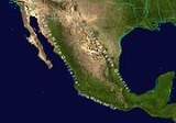
Sierra Madre del Sur
Encyclopedia
Mountain range
A mountain range is a single, large mass consisting of a succession of mountains or narrowly spaced mountain ridges, with or without peaks, closely related in position, direction, formation, and age; a component part of a mountain system or of a mountain chain...
in southern Mexico
Mexico
The United Mexican States , commonly known as Mexico , is a federal constitutional republic in North America. It is bordered on the north by the United States; on the south and west by the Pacific Ocean; on the southeast by Guatemala, Belize, and the Caribbean Sea; and on the east by the Gulf of...
, extending 1000 kilometres (621.4 mi) from southern Michoacán
Michoacán
Michoacán officially Estado Libre y Soberano de Michoacán de Ocampo is one of the 31 states which, with the Federal District, comprise the 32 Federal Entities of Mexico. It is divided in 113 municipalities and its capital city is Morelia...
east through Guerrero
Guerrero
Guerrero officially Estado Libre y Soberano de Guerrero is one of the 31 states which, with the Federal District, comprise the 32 Federal Entities of Mexico. It is divided in 81 municipalities and its capital city is Chilpancingo....
, to the Istmo de Tehuantepec
Isthmus of Tehuantepec
The Isthmus of Tehuantepec is an isthmus in Mexico. It represents the shortest distance between the Gulf of Mexico and the Pacific Ocean, and prior to the opening of the Panama Canal was a major shipping route known simply as the Tehuantepec Route...
in eastern Oaxaca.
Geography
The Sierra Madre del Sur joins with the Eje Volcánico TransversalTrans-Mexican volcanic belt
The Trans-Mexican Volcanic Belt also known as the Transvolcanic Belt and locally as the Sierra Nevada , is a volcanic belt that extends 900 km from west to east across central-southern Mexico...
(Trans-Mexican Volcanic Belt) of central Mexico in northern Oaxaca, but is separated from this range further west by the valley of the Río Balsas and its tributary the Río Tepalcatepec.
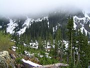
The mountains' highest point is 3703 metres (12,149 ft), located at 17°33′N 100°18′W in central Guerrero.
Although separated from the main part of the Sierra Madre del Sur by the deep canyon of the lower Río Balsas, the mountains of southern Michoacán around Coalcomán are usually considered part of the Sierra Madre del Sur.
Ecology
The range is noted for its very high biodiversityBiodiversity
Biodiversity is the degree of variation of life forms within a given ecosystem, biome, or an entire planet. Biodiversity is a measure of the health of ecosystems. Biodiversity is in part a function of climate. In terrestrial habitats, tropical regions are typically rich whereas polar regions...
and large number of endemic species.
The Sierra Madre del Sur pine-oak forests
Sierra Madre del Sur pine-oak forests
The Sierra Madre del Sur pine-oak forests is a subtropical coniferous forest ecoregion of the Sierra Madre del Sur mountain range of southern Mexico.-Setting:...
occupy the higher reaches of the range. These forests are part of a chain of Mesoamerican pine-oak forests
Mesoamerican pine-oak forests
The Mesoamerican pine-oak forests is a composite ecoregion of southern Mexico and Central America, designated by the World Wildlife Fund as one of their Global 200 ecoregions, a list of priority ecoregions for conservation....
that stretch from the Southwestern United States
Southwestern United States
The Southwestern United States is a region defined in different ways by different sources. Broad definitions include nearly a quarter of the United States, including Arizona, California, Colorado, Nevada, New Mexico, Oklahoma, Texas and Utah...
to Costa Rica
Costa Rica
Costa Rica , officially the Republic of Costa Rica is a multilingual, multiethnic and multicultural country in Central America, bordered by Nicaragua to the north, Panama to the southeast, the Pacific Ocean to the west and the Caribbean Sea to the east....
along the American Cordillera
American cordillera
The American Cordillera is a cordillera that consists of an essentially continuous sequence of mountain ranges that form the western "backbone" of North America, Central America, South America and Antarctica. From north to south, this sequence of overlapping and parallel ranges begins with the...
.
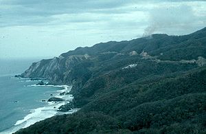
Lower elevations of the range are covered by tropical dry forests, ecoregion
Ecoregion
An ecoregion , sometimes called a bioregion, is an ecologically and geographically defined area that is smaller than an ecozone and larger than an ecosystem. Ecoregions cover relatively large areas of land or water, and contain characteristic, geographically distinct assemblages of natural...
s in the Tropical and subtropical dry broadleaf forests
Tropical and subtropical dry broadleaf forests
The tropical and subtropical dry broadleaf forest biome, also known as tropical dry forest, is located at tropical and subtropical latitudes. Though these forests occur in climates that are warm year-round, and may receive several hundred centimeters of rain per year, they have long dry seasons...
Biome
Biome
Biomes are climatically and geographically defined as similar climatic conditions on the Earth, such as communities of plants, animals, and soil organisms, and are often referred to as ecosystems. Some parts of the earth have more or less the same kind of abiotic and biotic factors spread over a...
. The Jalisco dry forests occupy the western end of the range's Pacific slope. The Southern Pacific dry forests occupy most of the Pacific slope of the range, from Michoacan in the west through Guerrero and Oaxaca. The basin of the Balsas River, north of the Sierra, is home to the Balsas dry forests
Balsas dry forests
The Balsas dry forests are a tropical dry broadleaf forest ecoregion of southern Mexico.-Setting:The Balsas dry forests occupy the basin of the Balsas River. the ecoregion covers an area of , extending across portions of Michoacan, Guerrero, Mexico, Morelos, Puebla, and Oaxaca states...
.