

Municipalities of Oaxaca
Encyclopedia
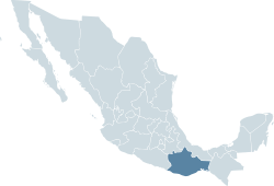
Mexico
The United Mexican States , commonly known as Mexico , is a federal constitutional republic in North America. It is bordered on the north by the United States; on the south and west by the Pacific Ocean; on the southeast by Guatemala, Belize, and the Caribbean Sea; and on the east by the Gulf of...
state
States of Mexico
The United Mexican States is a federal republic formed by 32 federal entities .According to the Constitution of 1917, the states of the federation are free and sovereign. Each state has their own congress and constitution, while the Federal District has only limited autonomy with a local Congress...
of Oaxaca
Oaxaca
Oaxaca , , officially Estado Libre y Soberano de Oaxaca is one of the 31 states which, along with the Federal District, comprise the 32 federative entities of Mexico. It is divided into 571 municipalities; of which 418 are governed by the system of customs and traditions...
is made up of 571 municipalities (municipios)—more than any other state.
|- style="text-align:center; background:#d8edff;"
!INEGI
National Institute of Statistics, Geography, and Data Processing
The National Institute of Statistic and Geography is an autonomous agency of the Mexican Government dedicated to coordinate the National System of Statistical and Geographical Information of the country...
code!!Municipality!!Municipal Seat!!District
|-
|001 || Abejones
Abejones
Abejones is a town and municipality in Oaxaca in south-western Mexico. The municipality covers an area of 122.48 km². It is part of the Ixtlán District in the Sierra Norte de Oaxaca region...
|| Abejones
Abejones
Abejones is a town and municipality in Oaxaca in south-western Mexico. The municipality covers an area of 122.48 km². It is part of the Ixtlán District in the Sierra Norte de Oaxaca region...
|| Ixtlán
Ixtlán District, Oaxaca
Ixtlán District is located in the northeast of the Sierra Norte region of the State of Oaxaca, Mexico.The district includes 26 municipalities, bringing together a total of 161 settlements which at the 2000 census had between them 40,218 inhabitants, the majority of them indigenous Zapotec...
|-
|002 || Acatlán de Pérez Figueroa
Acatlán de Pérez Figueroa
Acatlán de Pérez Figueroa is a town and municipality in Oaxaca in south-western Mexico.It is part of the Tuxtepec District of the Papaloapan Region.The name "Acatlán" means "among the reeds"...
|| Acatlán de Pérez Figueroa
Acatlán de Pérez Figueroa
Acatlán de Pérez Figueroa is a town and municipality in Oaxaca in south-western Mexico.It is part of the Tuxtepec District of the Papaloapan Region.The name "Acatlán" means "among the reeds"...
|| Tuxtepec
Tuxtepec District, Oaxaca
Tuxtepec District is located in the north of the Papaloapan Region of the State of Oaxaca, Mexico.-Municipalities:The district includes the following municipalities:*Acatlán de Pérez Figueroa*Ayotzintepec*Cosolapa*Loma Bonita*San Felipe Jalapa de Díaz...
|-
|003 || Animas Trujano, Oaxaca
Animas Trujano, Oaxaca
Animas Trujano is a town and municipality in Oaxaca in south-western Mexico. The municipality covers an area of 6.7 km², and it is part of the Centro District in the Valles Centrales region. Its climate is warm most of the time, and the municipal area has a diversity of both animal and plant species...
|| Animas Trujano, Oaxaca
Animas Trujano, Oaxaca
Animas Trujano is a town and municipality in Oaxaca in south-western Mexico. The municipality covers an area of 6.7 km², and it is part of the Centro District in the Valles Centrales region. Its climate is warm most of the time, and the municipal area has a diversity of both animal and plant species...
|| Centro
Centro District, Oaxaca
Centro District is located in the Valles Centrales Region of the State of Oaxaca, Mexico. The district includes the state capital Oaxaca and satellite towns.The district has an average elevation of 1,550 meters....
|-
|004 || Asunción Cacalotepec
Asunción Cacalotepec
Asunción Cacalotepec is a town and municipality in Oaxaca, Mexico. The municipality covers an area of 76.55 km². It is part of the Sierra Mixe district within the Sierra Norte de Oaxaca Region. As of 2005, the municipality had a total population of 753....
|| Asunción Cacalotepec
Asunción Cacalotepec
Asunción Cacalotepec is a town and municipality in Oaxaca, Mexico. The municipality covers an area of 76.55 km². It is part of the Sierra Mixe district within the Sierra Norte de Oaxaca Region. As of 2005, the municipality had a total population of 753....
|| Mixe
Sierra Mixe
The Sierra Mixe or Mixes District is a district in the east of the Sierra Norte Region of the Mexican state of Oaxaca. It comprises 17 municipalities and covers 4,930 km2 at an average elevation of 1,200 meters above sea level....
|-
|005 || Asunción Cuyotepeji
Asunción Cuyotepeji
Asunción Cuyotepeji is a town and municipality in Oaxaca in south-western Mexico. The municipality covers an area of 547.33 km².It is part of the Huajuapan District in the north of the Mixteca Region...
|| Asunción Cuyotepeji
Asunción Cuyotepeji
Asunción Cuyotepeji is a town and municipality in Oaxaca in south-western Mexico. The municipality covers an area of 547.33 km².It is part of the Huajuapan District in the north of the Mixteca Region...
|| Huajuapan
Huajuapan District, Oaxaca
Huajuapan District is located in the north of the Mixteca Region of the State of Oaxaca, Mexico. The principal city is Huajuapan de León.-Municipalities:The district includes the following municipalities:*Asunción Cuyotepeji*Cosoltepec...
|-
|006 || Asunción Ixtaltepec
Asunción Ixtaltepec
Asunción Ixtaltepec is a town and municipality in Oaxaca in south-western Mexico.It is part of the Juchitán District in the west of the Istmo de Tehuantepec region.The town was founded in 1546.The name means "White Mountain".-Environment:...
|| Asunción Ixtaltepec
Asunción Ixtaltepec
Asunción Ixtaltepec is a town and municipality in Oaxaca in south-western Mexico.It is part of the Juchitán District in the west of the Istmo de Tehuantepec region.The town was founded in 1546.The name means "White Mountain".-Environment:...
|| Juchitán
Juchitán District, Oaxaca
Juchitán District is located in the east of the Istmo de Tehuantepec region of the State of Oaxaca, Mexico, covering the southern part of a low lying corridor through the mountains that separates the Gulf of Mexico from the Pacific ocean....
|-
|007 || Asunción Nochixtlán
Asunción Nochixtlán
Asunción Nochixtlán is a town and municipality in Oaxaca in south-western Mexico. The municipality covers an area of 820.35 km². It is part of the Nochixtlán District in the southeast of the Mixteca Region. The settlement, originally called Neochixtlán, was founded in 909 C.C., as a Mixtec...
|| Asunción Nochixtlán
Asunción Nochixtlán
Asunción Nochixtlán is a town and municipality in Oaxaca in south-western Mexico. The municipality covers an area of 820.35 km². It is part of the Nochixtlán District in the southeast of the Mixteca Region. The settlement, originally called Neochixtlán, was founded in 909 C.C., as a Mixtec...
|| Nochixtlán
Nochixtlán District, Oaxaca
Nochixtlán District is located in the southeast of the Mixteca Region of the State of Oaxaca, Mexico.The main city is Asunción Nochixtlán.-Municipalities:The district includes the following municipalities:*Asunción Nochixtlán*Magdalena Jaltepec...
|-
|008 || Asunción Ocotlán
Asunción Ocotlán
Asunción Ocotlán is a town and municipality in Oaxaca in south-western Mexico. The municipality covers an area of 12.76 km². It is part of the Ocotlán District in the south of the Valles Centrales Region. Its name "Asunción" alludes the assumption of Mary and Ocotlán means between ocotes...
|| Asunción Ocotlán
Asunción Ocotlán
Asunción Ocotlán is a town and municipality in Oaxaca in south-western Mexico. The municipality covers an area of 12.76 km². It is part of the Ocotlán District in the south of the Valles Centrales Region. Its name "Asunción" alludes the assumption of Mary and Ocotlán means between ocotes...
|| Ocotlán
Ocotlán District, Oaxaca
Ocotlán District is located in the south of the Valles Centrales Region of the State of Oaxaca, Mexico.-Municipalities:The district includes the following municipalities:*Asunción Ocotlán*Magdalena Ocotlán*Ocotlán de Morelos...
|-
|009 || Asunción Tlacolulita
Asunción Tlacolulita
Asunción Tlacolulita is a town and municipality in Oaxaca in south-western Mexico.It is part of the Yautepec District in the east of the Sierra Sur Region....
|| Asunción Tlacolulita
Asunción Tlacolulita
Asunción Tlacolulita is a town and municipality in Oaxaca in south-western Mexico.It is part of the Yautepec District in the east of the Sierra Sur Region....
|| Yautepec
Yautepec District, Oaxaca
Yautepec District is located in the east of the Sierra Sur Region of the State of Oaxaca, Mexico.-Environment:The district lies in the eastern end of the Sierra Madre del Sur and is mountainous, with an area of 4,772 square kilometers....
|-
|010 || Ayoquezco de Aldama
Ayoquezco de Aldama
Ayoquezco de Aldama is a town and municipality in Oaxaca in south-western Mexico. The municipality covers an area of 58.69 km².It is part of the Zimatlán District in the west of the Valles Centrales Region...
|| Ayoquezco de Aldama
Ayoquezco de Aldama
Ayoquezco de Aldama is a town and municipality in Oaxaca in south-western Mexico. The municipality covers an area of 58.69 km².It is part of the Zimatlán District in the west of the Valles Centrales Region...
|| Zimatlán
Zimatlán District, Oaxaca
Zimatlán District is located in the west of the Valles Centrales Region of the State of Oaxaca, Mexico.-Municipalities:The district includes the following municipalities:*Ayoquezco de Aldama*Ciénega de Zimatlán*Magdalena Mixtepec*San Antonino El Alto...
|-
|011 || Ayotzintepec
Ayotzintepec
Ayotzintepec is a town and municipality in Oaxaca in south-western Mexico. The municipality covers an area of 169.69 km².It is part of the Tuxtepec District of the Papaloapan Region.As of 2005, the municipality had a total population of 6524....
|| Ayotzintepec
Ayotzintepec
Ayotzintepec is a town and municipality in Oaxaca in south-western Mexico. The municipality covers an area of 169.69 km².It is part of the Tuxtepec District of the Papaloapan Region.As of 2005, the municipality had a total population of 6524....
|| Tuxtepec
Tuxtepec District, Oaxaca
Tuxtepec District is located in the north of the Papaloapan Region of the State of Oaxaca, Mexico.-Municipalities:The district includes the following municipalities:*Acatlán de Pérez Figueroa*Ayotzintepec*Cosolapa*Loma Bonita*San Felipe Jalapa de Díaz...
|-
|012 || Calihuala
Calihuala
Calihuala is a town and municipality in Oaxaca in south-western Mexico. The municipality covers an area of 132.69 km². It is part of the Silacayoapam District in the Mixteca Region.As of 2005, the municipality had a total population of 1,057....
|| Calihuala
Calihuala
Calihuala is a town and municipality in Oaxaca in south-western Mexico. The municipality covers an area of 132.69 km². It is part of the Silacayoapam District in the Mixteca Region.As of 2005, the municipality had a total population of 1,057....
|| Silacayoapam
Silacayoapam District, Oaxaca
Silacayoapam District is located in the northwest of the Mixteca Region of the State of Oaxaca, Mexico.The climate is temperate, with average temperature of 20.6°C...
|-
|013 || Candelaria Loxicha
Candelaria Loxicha
Candelaria Loxicha is a town and municipality in Oaxaca in south-western Mexico. The municipality covers an area of 86.8 km².It is part of the Pochutla District in the east of the Costa Region.As of 2005, the municipality had a total population of 8686....
|| Candelaria Loxicha
Candelaria Loxicha
Candelaria Loxicha is a town and municipality in Oaxaca in south-western Mexico. The municipality covers an area of 86.8 km².It is part of the Pochutla District in the east of the Costa Region.As of 2005, the municipality had a total population of 8686....
|| Pochutla
Pochutla District, Oaxaca
Pochutla District is located in the east of the Costa Region of the State of Oaxaca, Mexico. The primary city is San Pedro Pochutla.-Municipalities:The district includes the following municipalities:* Candelaria Loxicha* Pluma Hidalgo...
|-
|014 || Capulalpam de Méndez
Capulalpam de Méndez
Capulalpam de Méndez is a town and municipality in the Sierra Juárez in Oaxaca in south-western Mexico.It is part of the Ixtlán District in the Sierra Norte de Oaxaca region....
|| Capulalpam de Méndez
Capulalpam de Méndez
Capulalpam de Méndez is a town and municipality in the Sierra Juárez in Oaxaca in south-western Mexico.It is part of the Ixtlán District in the Sierra Norte de Oaxaca region....
|| Ixtlán
Ixtlán District, Oaxaca
Ixtlán District is located in the northeast of the Sierra Norte region of the State of Oaxaca, Mexico.The district includes 26 municipalities, bringing together a total of 161 settlements which at the 2000 census had between them 40,218 inhabitants, the majority of them indigenous Zapotec...
|-
|015 || Chahuites
Chahuites
Chahuites is a town and municipality in Oaxaca in south-western Mexico. The municipality covers an area of 160.75 km².It is part of the Juchitán District in the west of the Istmo de Tehuantepec region...
|| Chahuites
Chahuites
Chahuites is a town and municipality in Oaxaca in south-western Mexico. The municipality covers an area of 160.75 km².It is part of the Juchitán District in the west of the Istmo de Tehuantepec region...
|| Juchitán
Juchitán District, Oaxaca
Juchitán District is located in the east of the Istmo de Tehuantepec region of the State of Oaxaca, Mexico, covering the southern part of a low lying corridor through the mountains that separates the Gulf of Mexico from the Pacific ocean....
|-
|016 || Chalcatongo de Hidalgo
Chalcatongo de Hidalgo
Chalcatongo de Hidalgo is a municipality in the Mexican state of Oaxaca. It is part of the Tlaxiaco District in the south of the Mixteca Region.It is the birthplace of current Governor Ulises Ruiz Ortiz....
|| Chalcatongo de Hidalgo
Chalcatongo de Hidalgo
Chalcatongo de Hidalgo is a municipality in the Mexican state of Oaxaca. It is part of the Tlaxiaco District in the south of the Mixteca Region.It is the birthplace of current Governor Ulises Ruiz Ortiz....
|| Tlaxiaco
Tlaxiaco District, Oaxaca
Tlaxiaco District is located in the south of the Mixteca Region of the State of Oaxaca, Mexico. The main city is the Heroic City of Tlaxiaco-Municipalities:The district includes the following municipalities:*Chalcatongo de Hidalgo*Magdalena Peñasco...
|-
|017 || Chilapa de Diaz
Santa María Chilapa de Diaz
Santa María Chilapa de Diaz is a town and municipality in Oaxaca in south-western Mexico.It is part of the Teposcolula District in the center of the Mixteca Region.The name Chilapa means "Water from chiles"....
|| Santa María Chilapa de Diaz
Santa María Chilapa de Diaz
Santa María Chilapa de Diaz is a town and municipality in Oaxaca in south-western Mexico.It is part of the Teposcolula District in the center of the Mixteca Region.The name Chilapa means "Water from chiles"....
|| Teposcolula
Teposcolula District, Oaxaca
Teposcolula District is located in the center of the Mixteca Region of the State of Oaxaca, Mexico.-Municipalities:The district includes the following municipalities:*Chilapa de Diaz*La Trinidad Vista Hermosa*San Andrés Lagunas...
|-
|018 || Chiquihuitlán de Benito Juárez
Chiquihuitlán de Benito Juárez
Chiquihuitlán de Benito Juárez is a town and municipality in Oaxaca in south-western Mexico. The municipality covers an area of 38.3 km².It is part of Cuicatlán District in the north of the Cañada Region....
|| Chiquihuitlán de Benito Juárez
Chiquihuitlán de Benito Juárez
Chiquihuitlán de Benito Juárez is a town and municipality in Oaxaca in south-western Mexico. The municipality covers an area of 38.3 km².It is part of Cuicatlán District in the north of the Cañada Region....
|| Cuicatlan
Cuicatlan District, Oaxaca
Cuicatlán District is located in the northeast of the Cañada Region of the State of Oaxaca, Mexico.-Municipalities:The district includes the following municipalities:*Chiquihuitlán de Benito Juárez*Concepción Pápalo*San Andrés Teotilalpam...
|-
|019 || Ciénega de Zimatlán
Ciénega de Zimatlán
Ciénega de Zimatlán is a town and municipality in Oaxaca in south-western Mexico. The municipality covers an area of 25.52 km².It is part of the Zimatlán District in the west of the Valles Centrales Region...
|| Ciénega de Zimatlán
Ciénega de Zimatlán
Ciénega de Zimatlán is a town and municipality in Oaxaca in south-western Mexico. The municipality covers an area of 25.52 km².It is part of the Zimatlán District in the west of the Valles Centrales Region...
|| Zimatlán
Zimatlán District, Oaxaca
Zimatlán District is located in the west of the Valles Centrales Region of the State of Oaxaca, Mexico.-Municipalities:The district includes the following municipalities:*Ayoquezco de Aldama*Ciénega de Zimatlán*Magdalena Mixtepec*San Antonino El Alto...
|-
|020 || Ciudad Ixtepec || Ciudad Ixtepec || Juchitán
Juchitán District, Oaxaca
Juchitán District is located in the east of the Istmo de Tehuantepec region of the State of Oaxaca, Mexico, covering the southern part of a low lying corridor through the mountains that separates the Gulf of Mexico from the Pacific ocean....
|-
|021 || Coatecas Altas
Coatecas Altas
Coatecas Altas is a town and municipality in Oaxaca in south-western Mexico. The municipality covers an area of 125.03 km².It is part of the Ejutla District in the south of the Valles Centrales Region....
|| Coatecas Altas
Coatecas Altas
Coatecas Altas is a town and municipality in Oaxaca in south-western Mexico. The municipality covers an area of 125.03 km².It is part of the Ejutla District in the south of the Valles Centrales Region....
|| Ejutla
Ejutla District, Oaxaca
Ejutla District is located in the south of the Valles Centrales Region of the State of Oaxaca, Mexico.-Municipalities:The district includes the following municipalities:*Coatecas Altas*Ejutla de Crespo*La Compañia*La Pe*San Agustín Amatengo...
|-
|022 || Coicoyan de Las Flores
Coicoyan de Las Flores
Coicoyan de Las Flores is a town and municipality in Oaxaca in south-western Mexico. The municipality covers an area of 105.89 km² and is part of the Juxtlahuaca district of the Mixteca Region. As of 2005, the municipality had a total population of 7,598.-History:The foundation of this town...
|| Coicoyan de Las Flores
Coicoyan de Las Flores
Coicoyan de Las Flores is a town and municipality in Oaxaca in south-western Mexico. The municipality covers an area of 105.89 km² and is part of the Juxtlahuaca district of the Mixteca Region. As of 2005, the municipality had a total population of 7,598.-History:The foundation of this town...
|| Juxtlahuaca
Juxtlahuaca District, Oaxaca
Juxtlahuaca District is located in the southwest of the Mixteca Region of the State of Oaxaca, Mexico. The largest town is Santiago Juxtlahuaca.The district is at an average elevation of 1,690 meters above sea level, and has an area of 1,848 km2....
|-
|023 || Concepción Buenavista
Concepción Buenavista
Concepción Buenavista is a town and municipality in Oaxaca in south-western Mexico. The municipality covers an area of 357.23 km².It is part of the Coixtlahuaca district in the Mixteca Region.As of 2005, the municipality had a total population of 828....
|| Concepción Buenavista
Concepción Buenavista
Concepción Buenavista is a town and municipality in Oaxaca in south-western Mexico. The municipality covers an area of 357.23 km².It is part of the Coixtlahuaca district in the Mixteca Region.As of 2005, the municipality had a total population of 828....
|| Coixtlahuaca
Coixtlahuaca District, Oaxaca
Coixtlahuaca District is located in the northeast of the Mixteca Region of the State of Oaxaca, Mexico. As of 2005 the population was 9,018, down 2.8% from 2000.The region is generally from 2,000m to 3,000m high, mostly hilly or mountainous with small plains....
|-
|024 || Concepción Pápalo
Concepción Pápalo
Concepción Pápalo is a town and municipality in Oaxaca in south-western Mexico. The municipality covers an area of 94.4 km².It is part of Cuicatlán District in the north of the Cañada Region.As of 2005, the municipality had a total population of 2920....
|| Concepción Pápalo
Concepción Pápalo
Concepción Pápalo is a town and municipality in Oaxaca in south-western Mexico. The municipality covers an area of 94.4 km².It is part of Cuicatlán District in the north of the Cañada Region.As of 2005, the municipality had a total population of 2920....
|| Cuicatlan
Cuicatlan District, Oaxaca
Cuicatlán District is located in the northeast of the Cañada Region of the State of Oaxaca, Mexico.-Municipalities:The district includes the following municipalities:*Chiquihuitlán de Benito Juárez*Concepción Pápalo*San Andrés Teotilalpam...
|-
|025 || Constancia del Rosario
Constancia del Rosario
Constancia del Rosario is a town and municipality in Oaxaca in south-western Mexico. The municipality covers an area of 298.54 km².It is part of Putla District in the west of the Sierra Sur Region....
|| Constancia del Rosario
Constancia del Rosario
Constancia del Rosario is a town and municipality in Oaxaca in south-western Mexico. The municipality covers an area of 298.54 km².It is part of Putla District in the west of the Sierra Sur Region....
|| Putla
Putla District, Oaxaca
Putla District is located in the west of the Sierra Sur Region of the State of Oaxaca, Mexico.-Municipalities:The district includes the following municipalities:*Constancia del Rosario*La Reforma, Oaxaca*Mesones Hidalgo*Putla Villa de Guerrero...
|-
|026 || Cosolapa
Cosolapa
Cosolapa is a town and municipality in Oaxaca in south-western Mexico. The municipality covers an area of 149.27 km².It is part of the Tuxtepec District of the Papaloapan Region.As of 2005, the municipality had a total population of 14,305....
|| Cosolapa
Cosolapa
Cosolapa is a town and municipality in Oaxaca in south-western Mexico. The municipality covers an area of 149.27 km².It is part of the Tuxtepec District of the Papaloapan Region.As of 2005, the municipality had a total population of 14,305....
|| Tuxtepec
Tuxtepec District, Oaxaca
Tuxtepec District is located in the north of the Papaloapan Region of the State of Oaxaca, Mexico.-Municipalities:The district includes the following municipalities:*Acatlán de Pérez Figueroa*Ayotzintepec*Cosolapa*Loma Bonita*San Felipe Jalapa de Díaz...
|-
|027 || Cosoltepec
Cosoltepec
Cosoltepec is a town and municipality in Oaxaca in south-western Mexico. The municipality covers an area of 81.65 km².It is part of the Huajuapan District in the north of the Mixteca Region.As of 2005, the municipality had a total population of 1022....
|| Cosoltepec
Cosoltepec
Cosoltepec is a town and municipality in Oaxaca in south-western Mexico. The municipality covers an area of 81.65 km².It is part of the Huajuapan District in the north of the Mixteca Region.As of 2005, the municipality had a total population of 1022....
|| Huajuapan
Huajuapan District, Oaxaca
Huajuapan District is located in the north of the Mixteca Region of the State of Oaxaca, Mexico. The principal city is Huajuapan de León.-Municipalities:The district includes the following municipalities:*Asunción Cuyotepeji*Cosoltepec...
|-
|028 || Cuilapan de Guerrero
Cuilapan de Guerrero
Cuilapan de Guerrero is a town and municipality located in the central valley region of Oaxaca in southern Mexico. It is to the south of the capital city of Oaxaca on the road leading to Villa de Zaachila, and is in the Centro District in the Valles Centrales region.Cuilapan, originally called...
|| Cuilapan de Guerrero
Cuilapan de Guerrero
Cuilapan de Guerrero is a town and municipality located in the central valley region of Oaxaca in southern Mexico. It is to the south of the capital city of Oaxaca on the road leading to Villa de Zaachila, and is in the Centro District in the Valles Centrales region.Cuilapan, originally called...
|| Centro
Centro District, Oaxaca
Centro District is located in the Valles Centrales Region of the State of Oaxaca, Mexico. The district includes the state capital Oaxaca and satellite towns.The district has an average elevation of 1,550 meters....
|-
|029 || Ejutla de Crespo
Ejutla de Crespo
Ejutla de Crespo is a city and a municipality of the same name, in the central valleys of the Mexican state of Oaxaca.It is part of the Teotitlán District in the north of the Cañada Region....
|| Ejutla de Crespo
Ejutla de Crespo
Ejutla de Crespo is a city and a municipality of the same name, in the central valleys of the Mexican state of Oaxaca.It is part of the Teotitlán District in the north of the Cañada Region....
|| Ejutla
Ejutla District, Oaxaca
Ejutla District is located in the south of the Valles Centrales Region of the State of Oaxaca, Mexico.-Municipalities:The district includes the following municipalities:*Coatecas Altas*Ejutla de Crespo*La Compañia*La Pe*San Agustín Amatengo...
|-
|030 || Eloxochitlán de Flores Magón
Eloxochitlán de Flores Magón
Eloxochitlán de Flores Magón, formerly known as San Antonio Eloxochitlán, is a city and municipality in the Mexican state of Oaxaca.It is part of the Teotitlán District in the north of the Cañada Region...
|| Eloxochitlán de Flores Magón
Eloxochitlán de Flores Magón
Eloxochitlán de Flores Magón, formerly known as San Antonio Eloxochitlán, is a city and municipality in the Mexican state of Oaxaca.It is part of the Teotitlán District in the north of the Cañada Region...
|| Teotitlan
Teotitlán District, Oaxaca
Teotitlán District is located in the north of the Cañada Region of the State of Oaxaca, Mexico.-Municipalities:The district includes the following municipalities:*Ejutla de Crespo*Eloxochitlán de Flores Magón*Huautepec...
|-
|031 || El Barrio de La Soledad
El Barrio de La Soledad
El Barrio de La Soledad is a town and municipality in Oaxaca in south-western Mexico. The municipality covers an area of 233.48 km².It is part of the Juchitán District in the west of the Istmo de Tehuantepec region...
|| El Barrio de La Soledad
El Barrio de La Soledad
El Barrio de La Soledad is a town and municipality in Oaxaca in south-western Mexico. The municipality covers an area of 233.48 km².It is part of the Juchitán District in the west of the Istmo de Tehuantepec region...
|| Juchitán
Juchitán District, Oaxaca
Juchitán District is located in the east of the Istmo de Tehuantepec region of the State of Oaxaca, Mexico, covering the southern part of a low lying corridor through the mountains that separates the Gulf of Mexico from the Pacific ocean....
|-
|032 || El Espinal || El Espinal || Juchitán
Juchitán District, Oaxaca
Juchitán District is located in the east of the Istmo de Tehuantepec region of the State of Oaxaca, Mexico, covering the southern part of a low lying corridor through the mountains that separates the Gulf of Mexico from the Pacific ocean....
|-
|033 || Evangelista Analco
Evangelista Analco
Evangelista Analco is a town and municipality in Oaxaca in south-western Mexico. The municipality covers an area of 33.17 km².It is part of the Ixtlán District in the Sierra Norte de Oaxaca region....
|| Evangelista Analco
Evangelista Analco
Evangelista Analco is a town and municipality in Oaxaca in south-western Mexico. The municipality covers an area of 33.17 km².It is part of the Ixtlán District in the Sierra Norte de Oaxaca region....
|| Ixtlán
Ixtlán District, Oaxaca
Ixtlán District is located in the northeast of the Sierra Norte region of the State of Oaxaca, Mexico.The district includes 26 municipalities, bringing together a total of 161 settlements which at the 2000 census had between them 40,218 inhabitants, the majority of them indigenous Zapotec...
|-
|034 || Fresnillo de Trujano
Fresnillo de Trujano
Fresnillo de Trujano is a town and municipality in Oaxaca in south-western Mexico. The municipality covers an area of 98.24 km².It is part of the Huajuapan District in the north of the Mixteca Region....
|| Fresnillo de Trujano
Fresnillo de Trujano
Fresnillo de Trujano is a town and municipality in Oaxaca in south-western Mexico. The municipality covers an area of 98.24 km².It is part of the Huajuapan District in the north of the Mixteca Region....
|| Huajuapan
Huajuapan District, Oaxaca
Huajuapan District is located in the north of the Mixteca Region of the State of Oaxaca, Mexico. The principal city is Huajuapan de León.-Municipalities:The district includes the following municipalities:*Asunción Cuyotepeji*Cosoltepec...
|-
|035 || Guadalupe de Ramírez
Guadalupe de Ramírez
Guadalupe de Ramírez is a town and municipality in Oaxaca in south-western Mexico. The municipality covers an area of 59.96 km².It is part of the Silacayoapam District in the Mixteca Region.As of 2005, the municipality had a total population of 1214....
|| Guadalupe de Ramírez
Guadalupe de Ramírez
Guadalupe de Ramírez is a town and municipality in Oaxaca in south-western Mexico. The municipality covers an area of 59.96 km².It is part of the Silacayoapam District in the Mixteca Region.As of 2005, the municipality had a total population of 1214....
|| Silacayoapam
Silacayoapam District, Oaxaca
Silacayoapam District is located in the northwest of the Mixteca Region of the State of Oaxaca, Mexico.The climate is temperate, with average temperature of 20.6°C...
|-
|036 || Guadalupe Etla
Guadalupe Etla
Guadalupe Etla is a village and municipality in the Mexican state of Oaxaca. The municipality has a total area of 17.86 km ².Guadalupe Etla is part of the region of the central valleys of Oaxaca....
|| Guadalupe Etla
Guadalupe Etla
Guadalupe Etla is a village and municipality in the Mexican state of Oaxaca. The municipality has a total area of 17.86 km ².Guadalupe Etla is part of the region of the central valleys of Oaxaca....
|| Etla
Etla District, Oaxaca
Etla District is located in the north of the Valles Centrales Region of the State of Oaxaca, Mexico.-Municipalities:The district includes the following municipalities:*Guadalupe Etla*Magdalena Apasco*Nazareno Etla*Reyes Etla*San Agustín Etla...
|-
|037 || Guelatao de Juárez || San Pablo Guelatao de Juárez
San Pablo Guelatao
San Pablo Guelatao is a town in the Mexican state of Oaxaca and the seat of the municipality of Guelatao de Juárez, about 55 km north of the city of Oaxaca...
|| Ixtlán
Ixtlán District, Oaxaca
Ixtlán District is located in the northeast of the Sierra Norte region of the State of Oaxaca, Mexico.The district includes 26 municipalities, bringing together a total of 161 settlements which at the 2000 census had between them 40,218 inhabitants, the majority of them indigenous Zapotec...
|-
|038 || Guevea de Humboldt
Guevea de Humboldt
Guevea de Humboldt is a town and municipality in Oaxaca in south-western Mexico.It in the north of the Tehuantepec District, which is in the west of the Istmo Region.-History:...
|| Guevea de Humboldt
Guevea de Humboldt
Guevea de Humboldt is a town and municipality in Oaxaca in south-western Mexico.It in the north of the Tehuantepec District, which is in the west of the Istmo Region.-History:...
|| Tehuantepec
Tehuantepec
Tehuantepec is a city and municipality in the southeast of the Mexican state of Oaxaca. It is part of the Tehuantepec District in the west of the Istmo Region. The area was important in pre Hispanic period as part of a trade route that connected Central America with what is now the center of...
|-
|039 || Huajuapan de León
Huajuapan de leon
Heroica Ciudad de Huajuapan de León; in , meaning Place of Brave People) is a rural city with a surrounding municipality located in the northwestern part of the Mexican state of Oaxaca....
|| Huajuapan de León
Huajuapan de leon
Heroica Ciudad de Huajuapan de León; in , meaning Place of Brave People) is a rural city with a surrounding municipality located in the northwestern part of the Mexican state of Oaxaca....
|| Huajuapan
Huajuapan District, Oaxaca
Huajuapan District is located in the north of the Mixteca Region of the State of Oaxaca, Mexico. The principal city is Huajuapan de León.-Municipalities:The district includes the following municipalities:*Asunción Cuyotepeji*Cosoltepec...
|-
|040 || Huautepec
Huautepec
Huautepec is a town and municipality in Oaxaca in south-western Mexico. The municipality covers an area of km². It is part of the Teotitlán District in the north of the Cañada Region.As of 2005, the municipality had a total population of 5,672....
|| Huautepec
Huautepec
Huautepec is a town and municipality in Oaxaca in south-western Mexico. The municipality covers an area of km². It is part of the Teotitlán District in the north of the Cañada Region.As of 2005, the municipality had a total population of 5,672....
|| Teotitlan
Teotitlán District, Oaxaca
Teotitlán District is located in the north of the Cañada Region of the State of Oaxaca, Mexico.-Municipalities:The district includes the following municipalities:*Ejutla de Crespo*Eloxochitlán de Flores Magón*Huautepec...
|-
|041 || Huautla de Jiménez
Municipality of Huautla de Jiménez
Huautla de Jimenez is a town and municipality in the Mexican state of Oaxaca.It is part of the Teotitlán District in the north of the Cañada Region....
|| Huautla de Jiménez|| Teotitlan
Teotitlán District, Oaxaca
Teotitlán District is located in the north of the Cañada Region of the State of Oaxaca, Mexico.-Municipalities:The district includes the following municipalities:*Ejutla de Crespo*Eloxochitlán de Flores Magón*Huautepec...
|-
|042 || Ixpantepec Nieves
Ixpantepec Nieves
Ixpantepec Nieves is a town and municipality in Oaxaca in south-western Mexico. The municipality covers an area of 93.14 km².It is part of the Silacayoapam District in the Mixteca Region.As of 2005, the municipality had a total population of 1371....
|| Ixpantepec Nieves
Ixpantepec Nieves
Ixpantepec Nieves is a town and municipality in Oaxaca in south-western Mexico. The municipality covers an area of 93.14 km².It is part of the Silacayoapam District in the Mixteca Region.As of 2005, the municipality had a total population of 1371....
|| Silacayoapam
Silacayoapam District, Oaxaca
Silacayoapam District is located in the northwest of the Mixteca Region of the State of Oaxaca, Mexico.The climate is temperate, with average temperature of 20.6°C...
|-
|043 || Ixtlán de Juárez
Ixtlán de Juárez
Ixtlán de Juárez is a town and municipality in the Mexican state of Oaxaca about 65 km north of the city of Oaxaca on Federal Highway 175 towards Veracruz.It is part of the Ixtlán District in the Sierra Norte de Oaxaca region.-Municipality of Ixtlán:...
|| Ixtlán de Juárez
Ixtlán de Juárez
Ixtlán de Juárez is a town and municipality in the Mexican state of Oaxaca about 65 km north of the city of Oaxaca on Federal Highway 175 towards Veracruz.It is part of the Ixtlán District in the Sierra Norte de Oaxaca region.-Municipality of Ixtlán:...
|| Ixtlán
Ixtlán District, Oaxaca
Ixtlán District is located in the northeast of the Sierra Norte region of the State of Oaxaca, Mexico.The district includes 26 municipalities, bringing together a total of 161 settlements which at the 2000 census had between them 40,218 inhabitants, the majority of them indigenous Zapotec...
|-
|044 || Juchitán de Zaragoza
Juchitán de Zaragoza
Juchitán de Zaragoza is an indigenous town in the southeast of the Mexican state of Oaxaca.It is part of the Juchitán District in the west of the Istmo de Tehuantepec region...
|| Juchitán de Zaragoza
Juchitán de Zaragoza
Juchitán de Zaragoza is an indigenous town in the southeast of the Mexican state of Oaxaca.It is part of the Juchitán District in the west of the Istmo de Tehuantepec region...
|| Juchitán
Juchitán District, Oaxaca
Juchitán District is located in the east of the Istmo de Tehuantepec region of the State of Oaxaca, Mexico, covering the southern part of a low lying corridor through the mountains that separates the Gulf of Mexico from the Pacific ocean....
|-
|045 || La Compañia
La Compañia
La Compañia is a town and municipality in Oaxaca in south-western Mexico. The municipality covers an area of 93.13 km².It is part of the Ejutla District in the south of the Valles Centrales Region....
|| La Compañia
La Compañia
La Compañia is a town and municipality in Oaxaca in south-western Mexico. The municipality covers an area of 93.13 km².It is part of the Ejutla District in the south of the Valles Centrales Region....
|| Ejutla
Ejutla District, Oaxaca
Ejutla District is located in the south of the Valles Centrales Region of the State of Oaxaca, Mexico.-Municipalities:The district includes the following municipalities:*Coatecas Altas*Ejutla de Crespo*La Compañia*La Pe*San Agustín Amatengo...
|-
|046 || La Pe
La Pe
La Pe is a town and municipality in Oaxaca in south-western Mexico. The municipality covers an area of km².It is part of the Ejutla District in the south of the Valles Centrales Region. This municipality is located in the central part of the state of Oaxaca, in the central valley region. It...
|| La Pe
La Pe
La Pe is a town and municipality in Oaxaca in south-western Mexico. The municipality covers an area of km².It is part of the Ejutla District in the south of the Valles Centrales Region. This municipality is located in the central part of the state of Oaxaca, in the central valley region. It...
|| Ejutla
Ejutla District, Oaxaca
Ejutla District is located in the south of the Valles Centrales Region of the State of Oaxaca, Mexico.-Municipalities:The district includes the following municipalities:*Coatecas Altas*Ejutla de Crespo*La Compañia*La Pe*San Agustín Amatengo...
|-
|047 || La Reforma
La Reforma, Oaxaca
La Reforma is a town and municipality in Oaxaca in south-western Mexico. The municipality covers an area of 496.3 km².It is part of Putla District in the west of the Sierra Sur Region.As of 2005, the municipality had a total population of 3096....
|| La Reforma
La Reforma, Oaxaca
La Reforma is a town and municipality in Oaxaca in south-western Mexico. The municipality covers an area of 496.3 km².It is part of Putla District in the west of the Sierra Sur Region.As of 2005, the municipality had a total population of 3096....
|| Putla
Putla District, Oaxaca
Putla District is located in the west of the Sierra Sur Region of the State of Oaxaca, Mexico.-Municipalities:The district includes the following municipalities:*Constancia del Rosario*La Reforma, Oaxaca*Mesones Hidalgo*Putla Villa de Guerrero...
|-
|048 || La Trinidad Vista Hermosa
La Trinidad Vista Hermosa
La Trinidad Vista Hermosa is a town and municipality in Oaxaca in south-western Mexico. The municipality covers an area of 31.9 km². It is part of the Teposcolula District in the center of the Mixteca Region. This municipality is located at the north east part of the state, at 2,160 meters above...
|| La Trinidad Vista Hermosa
La Trinidad Vista Hermosa
La Trinidad Vista Hermosa is a town and municipality in Oaxaca in south-western Mexico. The municipality covers an area of 31.9 km². It is part of the Teposcolula District in the center of the Mixteca Region. This municipality is located at the north east part of the state, at 2,160 meters above...
|| Teposcolula
Teposcolula District, Oaxaca
Teposcolula District is located in the center of the Mixteca Region of the State of Oaxaca, Mexico.-Municipalities:The district includes the following municipalities:*Chilapa de Diaz*La Trinidad Vista Hermosa*San Andrés Lagunas...
|-
|049 || Loma Bonita
Loma Bonita
Loma Bonita is a town and municipality in Oaxaca in south-western Mexico. The municipality covers an area of 588.15 km².It is part of the Tuxtepec District of the Papaloapan Region. At the beginning Loma Bonita was an informal settlement of young Americans, who has established several...
|| Loma Bonita
Loma Bonita
Loma Bonita is a town and municipality in Oaxaca in south-western Mexico. The municipality covers an area of 588.15 km².It is part of the Tuxtepec District of the Papaloapan Region. At the beginning Loma Bonita was an informal settlement of young Americans, who has established several...
|| Tuxtepec
Tuxtepec District, Oaxaca
Tuxtepec District is located in the north of the Papaloapan Region of the State of Oaxaca, Mexico.-Municipalities:The district includes the following municipalities:*Acatlán de Pérez Figueroa*Ayotzintepec*Cosolapa*Loma Bonita*San Felipe Jalapa de Díaz...
|-
|050 || Magdalena Apasco
Magdalena Apasco
Magdalena Apasco is a town and municipality in Oaxaca in south-western Mexico. The municipality covers an area of 29.34 km².It is part of the Etla District in the Valles Centrales region.As of 2005, the municipality had a total population of 6148....
|| Magdalena Apasco
Magdalena Apasco
Magdalena Apasco is a town and municipality in Oaxaca in south-western Mexico. The municipality covers an area of 29.34 km².It is part of the Etla District in the Valles Centrales region.As of 2005, the municipality had a total population of 6148....
|| Etla
Etla District, Oaxaca
Etla District is located in the north of the Valles Centrales Region of the State of Oaxaca, Mexico.-Municipalities:The district includes the following municipalities:*Guadalupe Etla*Magdalena Apasco*Nazareno Etla*Reyes Etla*San Agustín Etla...
|-
|051 || Magdalena Jaltepec
Magdalena Jaltepec
Magdalena Jaltepec is a town and municipality in Oaxaca in south-western Mexico. The municipality covers an area of 184.99 km².It is part of the Nochixtlán District in the southeast of the Mixteca Region....
|| Magdalena Jaltepec
Magdalena Jaltepec
Magdalena Jaltepec is a town and municipality in Oaxaca in south-western Mexico. The municipality covers an area of 184.99 km².It is part of the Nochixtlán District in the southeast of the Mixteca Region....
|| Nochixtlán
Nochixtlán District, Oaxaca
Nochixtlán District is located in the southeast of the Mixteca Region of the State of Oaxaca, Mexico.The main city is Asunción Nochixtlán.-Municipalities:The district includes the following municipalities:*Asunción Nochixtlán*Magdalena Jaltepec...
|-
|052 || Magdalena Mixtepec
Magdalena Mixtepec
Magdalena Mixtepec is a town and municipality in Oaxaca in south-western Mexico. The municipality covers an area of 11.48 km².It is part of the Zimatlán District in the west of the Valles Centrales Region...
|| Magdalena Mixtepec
Magdalena Mixtepec
Magdalena Mixtepec is a town and municipality in Oaxaca in south-western Mexico. The municipality covers an area of 11.48 km².It is part of the Zimatlán District in the west of the Valles Centrales Region...
|| Zimatlán
Zimatlán District, Oaxaca
Zimatlán District is located in the west of the Valles Centrales Region of the State of Oaxaca, Mexico.-Municipalities:The district includes the following municipalities:*Ayoquezco de Aldama*Ciénega de Zimatlán*Magdalena Mixtepec*San Antonino El Alto...
|-
|053 || Magdalena Ocotlán
Magdalena Ocotlán
Magdalena Ocotlán is a town and municipality in Oaxaca in south-western Mexico. The municipality covers an area of 24.24 km².It is part of the Ocotlán District in the south of the Valles Centrales Region...
|| Magdalena Ocotlán
Magdalena Ocotlán
Magdalena Ocotlán is a town and municipality in Oaxaca in south-western Mexico. The municipality covers an area of 24.24 km².It is part of the Ocotlán District in the south of the Valles Centrales Region...
|| Ocotlán
Ocotlán District, Oaxaca
Ocotlán District is located in the south of the Valles Centrales Region of the State of Oaxaca, Mexico.-Municipalities:The district includes the following municipalities:*Asunción Ocotlán*Magdalena Ocotlán*Ocotlán de Morelos...
|-
|054 || Magdalena Peñasco
Magdalena Peñasco
Magdalena Peñasco is a town and municipality in Oaxaca in south-western Mexico. The municipality covers an area of 75.27 km².It is part of the Tlaxiaco District in the south of the Mixteca Region.As of 2005, the municipality had a total population of 3461....
|| Magdalena Peñasco
Magdalena Peñasco
Magdalena Peñasco is a town and municipality in Oaxaca in south-western Mexico. The municipality covers an area of 75.27 km².It is part of the Tlaxiaco District in the south of the Mixteca Region.As of 2005, the municipality had a total population of 3461....
|| Tlaxiaco
Tlaxiaco District, Oaxaca
Tlaxiaco District is located in the south of the Mixteca Region of the State of Oaxaca, Mexico. The main city is the Heroic City of Tlaxiaco-Municipalities:The district includes the following municipalities:*Chalcatongo de Hidalgo*Magdalena Peñasco...
|-
|055 || Magdalena Teitipac
Magdalena Teitipac
Magdalena Teitipac is a town and municipality in Oaxaca in south-western Mexico. The municipality covers an area of 48.5 km².It is part of the Tlacolula District in the east of the Valles Centrales Region....
|| Magdalena Teitipac
Magdalena Teitipac
Magdalena Teitipac is a town and municipality in Oaxaca in south-western Mexico. The municipality covers an area of 48.5 km².It is part of the Tlacolula District in the east of the Valles Centrales Region....
|| Tlacolula
Tlacolula District, Oaxaca
Tlacolula District is located in the east of the Valles Centrales Region of the State of Oaxaca, Mexico.-Municipalities:The district includes the following municipalities:*Magdalena Teitipac*Rojas de Cuauhtémoc*San Bartolomé Quialana...
|-
|056 || Magdalena Tequisistlán
Magdalena Tequisistlán
Magdalena Tequisistlán is a town and municipality in the Mexican state of Oaxaca, located southeast of Mexico City.It is part of the Tehuantepec District in the west of the Istmo Region.The town was founded in 1410 under the present name...
|| Magdalena Tequisistlán
Magdalena Tequisistlán
Magdalena Tequisistlán is a town and municipality in the Mexican state of Oaxaca, located southeast of Mexico City.It is part of the Tehuantepec District in the west of the Istmo Region.The town was founded in 1410 under the present name...
|| Tehuantepec
Tehuantepec
Tehuantepec is a city and municipality in the southeast of the Mexican state of Oaxaca. It is part of the Tehuantepec District in the west of the Istmo Region. The area was important in pre Hispanic period as part of a trade route that connected Central America with what is now the center of...
|-
|057 || Magdalena Tlacotepec
Magdalena Tlacotepec
Magdalena Tlacotepec is a town and municipality in Oaxaca in south-western Mexico. The municipality covers an area of 234.75 km².It is part of the Tehuantepec District in the west of the Istmo Region....
|| Magdalena Tlacotepec
Magdalena Tlacotepec
Magdalena Tlacotepec is a town and municipality in Oaxaca in south-western Mexico. The municipality covers an area of 234.75 km².It is part of the Tehuantepec District in the west of the Istmo Region....
|| Tehuantepec
Tehuantepec
Tehuantepec is a city and municipality in the southeast of the Mexican state of Oaxaca. It is part of the Tehuantepec District in the west of the Istmo Region. The area was important in pre Hispanic period as part of a trade route that connected Central America with what is now the center of...
|-
|058 || Magdalena Zahuatlán
Magdalena Zahuatlán
Magdalena Zahuatlán is a town and municipality in Oaxaca in south-western Mexico. The municipality covers an area of 70.2 km².It is part of the Nochixtlán District in the southeast of the Mixteca Region....
|| Magdalena Zahuatlán
Magdalena Zahuatlán
Magdalena Zahuatlán is a town and municipality in Oaxaca in south-western Mexico. The municipality covers an area of 70.2 km².It is part of the Nochixtlán District in the southeast of the Mixteca Region....
|| Nochixtlán
Nochixtlán District, Oaxaca
Nochixtlán District is located in the southeast of the Mixteca Region of the State of Oaxaca, Mexico.The main city is Asunción Nochixtlán.-Municipalities:The district includes the following municipalities:*Asunción Nochixtlán*Magdalena Jaltepec...
|-
|059 || Mariscala de Juárez
Mariscala de Juárez
Mariscala de Juárez is a town and municipality in Oaxaca in south-western Mexico. The municipality covers an area of 72.72 km².It is part of the Huajuapan District in the north of the Mixteca Region....
|| Mariscala de Juárez
Mariscala de Juárez
Mariscala de Juárez is a town and municipality in Oaxaca in south-western Mexico. The municipality covers an area of 72.72 km².It is part of the Huajuapan District in the north of the Mixteca Region....
|| Huajuapan
Huajuapan District, Oaxaca
Huajuapan District is located in the north of the Mixteca Region of the State of Oaxaca, Mexico. The principal city is Huajuapan de León.-Municipalities:The district includes the following municipalities:*Asunción Cuyotepeji*Cosoltepec...
|-
|060 || Mártires de Tacubaya
Mártires de Tacubaya
Mártires de Tacubaya is a town and municipality in Oaxaca in south-western Mexico. The municipality covers an area of 89.3 km².It is located in the Jamiltepec District in the west of the Costa Region....
|| Mártires de Tacubaya
Mártires de Tacubaya
Mártires de Tacubaya is a town and municipality in Oaxaca in south-western Mexico. The municipality covers an area of 89.3 km².It is located in the Jamiltepec District in the west of the Costa Region....
|| Jamiltepec
Santiago Jamiltepec
Santiago Jamiltepec is a town, and the seat of surrounding municipality of the same name, in the Mexican state of Oaxaca....
|-
|061 || Matías Romero
Matías Romero
Matías Romero is a town and municipality in Oaxaca in south-western Mexico. The municipality covers an area of 1,459.54 km².It is part of the Juchitán District in the west of the Istmo de Tehuantepec region....
|| Matías Romero
Matías Romero
Matías Romero is a town and municipality in Oaxaca in south-western Mexico. The municipality covers an area of 1,459.54 km².It is part of the Juchitán District in the west of the Istmo de Tehuantepec region....
|| Juchitán
Juchitán District, Oaxaca
Juchitán District is located in the east of the Istmo de Tehuantepec region of the State of Oaxaca, Mexico, covering the southern part of a low lying corridor through the mountains that separates the Gulf of Mexico from the Pacific ocean....
|-
|062 || Mazatlán Villa de Flores
Mazatlán Villa de Flores
Mazatlán Villa de Flores is a town and municipality in Oaxaca in south-western Mexico. The municipality covers an area of 137.79 km².It is part of the Teotitlán District in the north of the Cañada Region....
|| Mazatlán Villa de Flores
Mazatlán Villa de Flores
Mazatlán Villa de Flores is a town and municipality in Oaxaca in south-western Mexico. The municipality covers an area of 137.79 km².It is part of the Teotitlán District in the north of the Cañada Region....
|| Teotitlan
Teotitlán District, Oaxaca
Teotitlán District is located in the north of the Cañada Region of the State of Oaxaca, Mexico.-Municipalities:The district includes the following municipalities:*Ejutla de Crespo*Eloxochitlán de Flores Magón*Huautepec...
|-
|063 || Mesones Hidalgo
Mesones Hidalgo
Mesones Hidalgo is a town and municipality in Oaxaca in south-western Mexico. The municipality covers an area of 353.4 km².It is part of Putla District in the west of the Sierra Sur Region.As of 2005, the municipality had a total population of 3961....
|| Mesones Hidalgo
Mesones Hidalgo
Mesones Hidalgo is a town and municipality in Oaxaca in south-western Mexico. The municipality covers an area of 353.4 km².It is part of Putla District in the west of the Sierra Sur Region.As of 2005, the municipality had a total population of 3961....
|| Putla
Putla District, Oaxaca
Putla District is located in the west of the Sierra Sur Region of the State of Oaxaca, Mexico.-Municipalities:The district includes the following municipalities:*Constancia del Rosario*La Reforma, Oaxaca*Mesones Hidalgo*Putla Villa de Guerrero...
|-
|064 || Miahuatlán de Porfirio Díaz
Miahuatlán de Porfirio Díaz
Miahuatlán de Porfirio Díaz is a town and municipality in Oaxaca in south-eastern Mexico. The municipality covers an area of 326.6 km², and is at an average elevation of 1,600 meters.It is part of the Miahuatlán District in the south of the Sierra Sur Region....
|| Miahuatlán de Porfirio Díaz
Miahuatlán de Porfirio Díaz
Miahuatlán de Porfirio Díaz is a town and municipality in Oaxaca in south-eastern Mexico. The municipality covers an area of 326.6 km², and is at an average elevation of 1,600 meters.It is part of the Miahuatlán District in the south of the Sierra Sur Region....
|| Miahuatlán
Miahuatlán District, Oaxaca
Miahuatlán District is located in the south of the Sierra Sur Region of the State of Oaxaca, Mexico.-Municipalities:The district includes the following municipalities:*Miahuatlán de Porfirio Díaz*Monjas*San Andrés Paxtlan*San Cristobal Amatlán...
|-
|065 || Mixistlán de la Reforma
Mixistlán de la Reforma
Mixistlán de la Reforma is a town and municipality in Oaxaca in south-western Mexico. The municipality covers an area of 191.4 km².It is part of the Sierra Mixe district within the Sierra Norte de Oaxaca Region....
|| Mixistlán de la Reforma
Mixistlán de la Reforma
Mixistlán de la Reforma is a town and municipality in Oaxaca in south-western Mexico. The municipality covers an area of 191.4 km².It is part of the Sierra Mixe district within the Sierra Norte de Oaxaca Region....
|| Mixe
Sierra Mixe
The Sierra Mixe or Mixes District is a district in the east of the Sierra Norte Region of the Mexican state of Oaxaca. It comprises 17 municipalities and covers 4,930 km2 at an average elevation of 1,200 meters above sea level....
|-
|066 || Monjas
Monjas, Oaxaca
Monjas is a town and municipality in Oaxaca in south-western Mexico. The municipality covers an area of 85.5 km².It is part of the Miahuatlán District in the south of the Sierra Sur Region.As of 2005, the municipality had a total population of 2104....
|| Monjas
Monjas, Oaxaca
Monjas is a town and municipality in Oaxaca in south-western Mexico. The municipality covers an area of 85.5 km².It is part of the Miahuatlán District in the south of the Sierra Sur Region.As of 2005, the municipality had a total population of 2104....
|| Miahuatlán
Miahuatlán District, Oaxaca
Miahuatlán District is located in the south of the Sierra Sur Region of the State of Oaxaca, Mexico.-Municipalities:The district includes the following municipalities:*Miahuatlán de Porfirio Díaz*Monjas*San Andrés Paxtlan*San Cristobal Amatlán...
|-
|067 || Natividad
Natividad, Oaxaca
Natividad is a town and municipality in Oaxaca in south-western Mexico. The municipality covers an area of 28.07 km².It is part of the Ixtlán District in the Sierra Norte de Oaxaca region.As of 2005, the municipality had a total population of 546....
|| Natividad
Natividad, Oaxaca
Natividad is a town and municipality in Oaxaca in south-western Mexico. The municipality covers an area of 28.07 km².It is part of the Ixtlán District in the Sierra Norte de Oaxaca region.As of 2005, the municipality had a total population of 546....
|| Ixtlán
Ixtlán District, Oaxaca
Ixtlán District is located in the northeast of the Sierra Norte region of the State of Oaxaca, Mexico.The district includes 26 municipalities, bringing together a total of 161 settlements which at the 2000 census had between them 40,218 inhabitants, the majority of them indigenous Zapotec...
|-
|068 || Nazareno Etla
Nazareno Etla
Nazareno Etla is a town and municipality in Oaxaca in south-western Mexico. The municipality covers an area of 16.59 km².It is part of the Etla District in the Valles Centrales region.As of 2005, the municipality had a total population of 3720....
|| Nazareno Etla
Nazareno Etla
Nazareno Etla is a town and municipality in Oaxaca in south-western Mexico. The municipality covers an area of 16.59 km².It is part of the Etla District in the Valles Centrales region.As of 2005, the municipality had a total population of 3720....
|| Etla
Etla District, Oaxaca
Etla District is located in the north of the Valles Centrales Region of the State of Oaxaca, Mexico.-Municipalities:The district includes the following municipalities:*Guadalupe Etla*Magdalena Apasco*Nazareno Etla*Reyes Etla*San Agustín Etla...
|-
|069 || Nejapa de Madero
Nejapa de Madero
Nejapa de Madero is a town and municipality in Oaxaca in south-western Mexico.It is part of the Yautepec District in the east of the Sierra Sur Region, not far from the main highway between Oaxaca, Oaxaca and Salina Cruz.The name "Nejapa" means "ash water"....
|| Nejapa de Madero
Nejapa de Madero
Nejapa de Madero is a town and municipality in Oaxaca in south-western Mexico.It is part of the Yautepec District in the east of the Sierra Sur Region, not far from the main highway between Oaxaca, Oaxaca and Salina Cruz.The name "Nejapa" means "ash water"....
|| Yautepec
Yautepec District, Oaxaca
Yautepec District is located in the east of the Sierra Sur Region of the State of Oaxaca, Mexico.-Environment:The district lies in the eastern end of the Sierra Madre del Sur and is mountainous, with an area of 4,772 square kilometers....
|-
|070 || Nuevo Zoquiapam
Nuevo Zoquiapam
Nuevo Zoquiapam is a town and municipality in Oaxaca in south-western Mexico. The municipality covers an area of 74 km².It is part of the Ixtlán District in the Sierra Norte de Oaxaca region.As of 2005, the municipality had a total population of 1486....
|| Nuevo Zoquiapam
Nuevo Zoquiapam
Nuevo Zoquiapam is a town and municipality in Oaxaca in south-western Mexico. The municipality covers an area of 74 km².It is part of the Ixtlán District in the Sierra Norte de Oaxaca region.As of 2005, the municipality had a total population of 1486....
|| Ixtlán
Ixtlán District, Oaxaca
Ixtlán District is located in the northeast of the Sierra Norte region of the State of Oaxaca, Mexico.The district includes 26 municipalities, bringing together a total of 161 settlements which at the 2000 census had between them 40,218 inhabitants, the majority of them indigenous Zapotec...
|-
|071 || Oaxaca de Juárez || Oaxaca de Juárez
Oaxaca, Oaxaca
The city and municipality of Oaxaca de Juárez, or simply Oaxaca, is the capital and largest city of the Mexican state of the same name . It is located in the Centro District in the Central Valleys region of the state, in the foothills of the Sierra Madre at the base of the Cerro del Fortín...
|| Centro
Centro District, Oaxaca
Centro District is located in the Valles Centrales Region of the State of Oaxaca, Mexico. The district includes the state capital Oaxaca and satellite towns.The district has an average elevation of 1,550 meters....
|-
|072 || Ocotlán de Morelos
Ocotlán de Morelos
Ocotlán de Morelos is a town and municipality in the state of Oaxaca, about 35 km south of the center of the city of Oaxaca along Highway 175....
|| Ocotlán de Morelos
Ocotlán de Morelos
Ocotlán de Morelos is a town and municipality in the state of Oaxaca, about 35 km south of the center of the city of Oaxaca along Highway 175....
|| Ocotlán
Ocotlán District, Oaxaca
Ocotlán District is located in the south of the Valles Centrales Region of the State of Oaxaca, Mexico.-Municipalities:The district includes the following municipalities:*Asunción Ocotlán*Magdalena Ocotlán*Ocotlán de Morelos...
|-
|073 || Pinotepa de Don Luis
Pinotepa de Don Luis
Pinotepa de Don Luis is a town and municipality in Oaxaca in south-western Mexico. The municipality covers an area of 51 km².It is located in the Jamiltepec District in the west of the Costa Region....
|| Pinotepa de Don Luis
Pinotepa de Don Luis
Pinotepa de Don Luis is a town and municipality in Oaxaca in south-western Mexico. The municipality covers an area of 51 km².It is located in the Jamiltepec District in the west of the Costa Region....
|| Jamiltepec
Santiago Jamiltepec
Santiago Jamiltepec is a town, and the seat of surrounding municipality of the same name, in the Mexican state of Oaxaca....
|-
|074 || Pinotepa Nacional
Pinotepa Nacional
Pinotepa Nacional is a city and seat of the municipality of the same name, in the Mexican state of Oaxaca....
|| Pinotepa Nacional
Pinotepa Nacional
Pinotepa Nacional is a city and seat of the municipality of the same name, in the Mexican state of Oaxaca....
|| Jamiltepec
Santiago Jamiltepec
Santiago Jamiltepec is a town, and the seat of surrounding municipality of the same name, in the Mexican state of Oaxaca....
|-
|075 || Pluma Hidalgo
Pluma Hidalgo
Pluma Hidalgo is a town and municipality in Oaxaca in south-western Mexico. The municipality covers an area of 179.9 km². It is part of the Pochutla District in the east of the Costa Region. The name of "Pluma Hidalgo" was given because there is a small mountain located on the municipality and up...
|| Pluma Hidalgo
Pluma Hidalgo
Pluma Hidalgo is a town and municipality in Oaxaca in south-western Mexico. The municipality covers an area of 179.9 km². It is part of the Pochutla District in the east of the Costa Region. The name of "Pluma Hidalgo" was given because there is a small mountain located on the municipality and up...
|| Pochutla
Pochutla District, Oaxaca
Pochutla District is located in the east of the Costa Region of the State of Oaxaca, Mexico. The primary city is San Pedro Pochutla.-Municipalities:The district includes the following municipalities:* Candelaria Loxicha* Pluma Hidalgo...
|-
|076 || Putla Villa de Guerrero
Putla Villa de Guerrero
Putla Villa de Guerrero or simply Putla, is a town and municipality in the State of Oaxaca, Mexico.It is part of Putla District in the west of the Sierra Sur Region....
|| Putla Villa de Guerrero
Putla Villa de Guerrero
Putla Villa de Guerrero or simply Putla, is a town and municipality in the State of Oaxaca, Mexico.It is part of Putla District in the west of the Sierra Sur Region....
|| Putla
Putla District, Oaxaca
Putla District is located in the west of the Sierra Sur Region of the State of Oaxaca, Mexico.-Municipalities:The district includes the following municipalities:*Constancia del Rosario*La Reforma, Oaxaca*Mesones Hidalgo*Putla Villa de Guerrero...
|-
|077 || Reforma de Pineda
Reforma de Pineda
Reforma de Pineda is a town and municipality in Oaxaca in south-western Mexico. The municipality covers an area of 193.92 km².It is part of the Juchitán District in the west of the Istmo de Tehuantepec region....
|| Reforma de Pineda
Reforma de Pineda
Reforma de Pineda is a town and municipality in Oaxaca in south-western Mexico. The municipality covers an area of 193.92 km².It is part of the Juchitán District in the west of the Istmo de Tehuantepec region....
|| Juchitán
Juchitán District, Oaxaca
Juchitán District is located in the east of the Istmo de Tehuantepec region of the State of Oaxaca, Mexico, covering the southern part of a low lying corridor through the mountains that separates the Gulf of Mexico from the Pacific ocean....
|-
|078 || Reyes Etla
Reyes Etla
Reyes Etla is a town and municipality in Oaxaca in south-western Mexico. The municipality covers an area of 24.24 km².It is part of the Etla District in the Valles Centrales region.As of 2005, the municipality had a total population of 3252....
|| Reyes Etla
Reyes Etla
Reyes Etla is a town and municipality in Oaxaca in south-western Mexico. The municipality covers an area of 24.24 km².It is part of the Etla District in the Valles Centrales region.As of 2005, the municipality had a total population of 3252....
|| Etla
Etla District, Oaxaca
Etla District is located in the north of the Valles Centrales Region of the State of Oaxaca, Mexico.-Municipalities:The district includes the following municipalities:*Guadalupe Etla*Magdalena Apasco*Nazareno Etla*Reyes Etla*San Agustín Etla...
|-
|079 || Rojas de Cuauhtémoc
Rojas de Cuauhtémoc
Rojas de Cuauhtémoc is a town and municipality in Oaxaca in south-western Mexico. The municipality covers an area of 25.52 km².It is part of the Tlacolula District in the east of the Valles Centrales Region....
|| Rojas de Cuauhtémoc
Rojas de Cuauhtémoc
Rojas de Cuauhtémoc is a town and municipality in Oaxaca in south-western Mexico. The municipality covers an area of 25.52 km².It is part of the Tlacolula District in the east of the Valles Centrales Region....
|| Tlacolula
Tlacolula District, Oaxaca
Tlacolula District is located in the east of the Valles Centrales Region of the State of Oaxaca, Mexico.-Municipalities:The district includes the following municipalities:*Magdalena Teitipac*Rojas de Cuauhtémoc*San Bartolomé Quialana...
|-
|080 || Salina Cruz
Salina Cruz
Salina Cruz is a major seaport on the Pacific coast of the Mexican state of Oaxaca. It is the state's third-largest city and is municipal seat of the municipality of the same name.It is part of the Tehuantepec District in the west of the Istmo Region....
|| Salina Cruz
Salina Cruz
Salina Cruz is a major seaport on the Pacific coast of the Mexican state of Oaxaca. It is the state's third-largest city and is municipal seat of the municipality of the same name.It is part of the Tehuantepec District in the west of the Istmo Region....
|| Tehuantepec
Tehuantepec
Tehuantepec is a city and municipality in the southeast of the Mexican state of Oaxaca. It is part of the Tehuantepec District in the west of the Istmo Region. The area was important in pre Hispanic period as part of a trade route that connected Central America with what is now the center of...
|-
|081 || San Agustín Amatengo
San Agustín Amatengo
San Agustín Amatengo is a town and municipality in Oaxaca in south-western Mexico. The municipality covers an area of 58.69 km².It is part of the Ejutla District in the south of the Valles Centrales Region....
|| San Agustín Amatengo
San Agustín Amatengo
San Agustín Amatengo is a town and municipality in Oaxaca in south-western Mexico. The municipality covers an area of 58.69 km².It is part of the Ejutla District in the south of the Valles Centrales Region....
|| Ejutla
Ejutla District, Oaxaca
Ejutla District is located in the south of the Valles Centrales Region of the State of Oaxaca, Mexico.-Municipalities:The district includes the following municipalities:*Coatecas Altas*Ejutla de Crespo*La Compañia*La Pe*San Agustín Amatengo...
|-
|082 || San Agustín Atenango
San Agustín Atenango
San Agustín Atenango is a town and municipality in Oaxaca in south-western Mexico. The municipality covers an area of 82.93 km².It is part of the Silacayoapam District in the Mixteca Region.As of 2005, the municipality had a total population of 1787....
|| San Agustín Atenango
San Agustín Atenango
San Agustín Atenango is a town and municipality in Oaxaca in south-western Mexico. The municipality covers an area of 82.93 km².It is part of the Silacayoapam District in the Mixteca Region.As of 2005, the municipality had a total population of 1787....
|| Silacayoapam
Silacayoapam District, Oaxaca
Silacayoapam District is located in the northwest of the Mixteca Region of the State of Oaxaca, Mexico.The climate is temperate, with average temperature of 20.6°C...
|-
|083 || San Agustín Chayuco
San Agustín Chayuco
San Agustín Chayuco is a town and municipality in Oaxaca in south-western Mexico. The municipality covers an area of 107.2 km².It is located in the Jamiltepec District in the west of the Costa Region....
|| San Agustín Chayuco
San Agustín Chayuco
San Agustín Chayuco is a town and municipality in Oaxaca in south-western Mexico. The municipality covers an area of 107.2 km².It is located in the Jamiltepec District in the west of the Costa Region....
|| Jamiltepec
Santiago Jamiltepec
Santiago Jamiltepec is a town, and the seat of surrounding municipality of the same name, in the Mexican state of Oaxaca....
|-
|084 || San Agustín de las Juntas
San Agustín de las Juntas
San Agustín de las Juntas is a town and municipality in Oaxaca in south-western Mexico. The municipality covers an area of 12.76 km².It is part of the Centro District in the Valles Centrales region....
|| San Agustín de las Juntas
San Agustín de las Juntas
San Agustín de las Juntas is a town and municipality in Oaxaca in south-western Mexico. The municipality covers an area of 12.76 km².It is part of the Centro District in the Valles Centrales region....
|| Centro
Centro District, Oaxaca
Centro District is located in the Valles Centrales Region of the State of Oaxaca, Mexico. The district includes the state capital Oaxaca and satellite towns.The district has an average elevation of 1,550 meters....
|-
|085 || San Agustín Etla
San Agustín Etla
San Agustín Etla is a town and municipality in Oaxaca in south-western Mexico. The municipality covers an area of 81.65 km².It is part of the Etla District in the Valles Centrales region.As of 2005, the municipality had a total population of 3243....
|| San Agustín Etla
San Agustín Etla
San Agustín Etla is a town and municipality in Oaxaca in south-western Mexico. The municipality covers an area of 81.65 km².It is part of the Etla District in the Valles Centrales region.As of 2005, the municipality had a total population of 3243....
|| Etla
Etla District, Oaxaca
Etla District is located in the north of the Valles Centrales Region of the State of Oaxaca, Mexico.-Municipalities:The district includes the following municipalities:*Guadalupe Etla*Magdalena Apasco*Nazareno Etla*Reyes Etla*San Agustín Etla...
|-
|086 || San Agustín Loxicha
San Agustín Loxicha
San Agustín Loxicha is a town and municipality in Oaxaca in south-western Mexico. The municipality covers an area of 389.1 km².It is part of the Pochutla District in the east of the Costa Region....
|| San Agustín Loxicha
San Agustín Loxicha
San Agustín Loxicha is a town and municipality in Oaxaca in south-western Mexico. The municipality covers an area of 389.1 km².It is part of the Pochutla District in the east of the Costa Region....
|| Pochutla
Pochutla District, Oaxaca
Pochutla District is located in the east of the Costa Region of the State of Oaxaca, Mexico. The primary city is San Pedro Pochutla.-Municipalities:The district includes the following municipalities:* Candelaria Loxicha* Pluma Hidalgo...
|-
|087 || San Agustín Tlacotepec
San Agustín Tlacotepec
San Agustín Tlacotepec is a town and municipality in Oaxaca in south-western Mexico. The municipality covers an area of 79.1 km².It is part of the Tlaxiaco District in the south of the Mixteca Region....
|| San Agustín Tlacotepec
San Agustín Tlacotepec
San Agustín Tlacotepec is a town and municipality in Oaxaca in south-western Mexico. The municipality covers an area of 79.1 km².It is part of the Tlaxiaco District in the south of the Mixteca Region....
|| Tlaxiaco
Tlaxiaco District, Oaxaca
Tlaxiaco District is located in the south of the Mixteca Region of the State of Oaxaca, Mexico. The main city is the Heroic City of Tlaxiaco-Municipalities:The district includes the following municipalities:*Chalcatongo de Hidalgo*Magdalena Peñasco...
|-
|088 || San Agustín Yatareni
San Agustín Yatareni
San Agustín Yatareni is a town and municipality in Oaxaca in southwestern Mexico. The municipality covers an area of 33.17 km².It is part of the Centro District in the Valles Centrales region.As of 2005 the municipality had a total population of 3,176....
|| San Agustín Yatareni
San Agustín Yatareni
San Agustín Yatareni is a town and municipality in Oaxaca in southwestern Mexico. The municipality covers an area of 33.17 km².It is part of the Centro District in the Valles Centrales region.As of 2005 the municipality had a total population of 3,176....
|| Centro
Centro District, Oaxaca
Centro District is located in the Valles Centrales Region of the State of Oaxaca, Mexico. The district includes the state capital Oaxaca and satellite towns.The district has an average elevation of 1,550 meters....
|-
|089 || San Andrés Cabecera Nueva
San Andrés Cabecera Nueva
San Andrés Cabecera Nueva is a town and municipality in Oaxaca in south-western Mexico. The municipality covers an area of 223.27 km².It is part of Putla District in the west of the Sierra Sur Region....
|| San Andrés Cabecera Nueva
San Andrés Cabecera Nueva
San Andrés Cabecera Nueva is a town and municipality in Oaxaca in south-western Mexico. The municipality covers an area of 223.27 km².It is part of Putla District in the west of the Sierra Sur Region....
|| Putla
Putla District, Oaxaca
Putla District is located in the west of the Sierra Sur Region of the State of Oaxaca, Mexico.-Municipalities:The district includes the following municipalities:*Constancia del Rosario*La Reforma, Oaxaca*Mesones Hidalgo*Putla Villa de Guerrero...
|-
|090 || San Andrés Dinicuiti
San Andrés Dinicuiti
San Andrés Dinicuiti is a town and municipality in Oaxaca in south-western Mexico. The municipality covers an area of 121.2 km².It is part of the Huajuapan District in the north of the Mixteca Region....
|| San Andrés Dinicuiti
San Andrés Dinicuiti
San Andrés Dinicuiti is a town and municipality in Oaxaca in south-western Mexico. The municipality covers an area of 121.2 km².It is part of the Huajuapan District in the north of the Mixteca Region....
|| Huajuapan
Huajuapan District, Oaxaca
Huajuapan District is located in the north of the Mixteca Region of the State of Oaxaca, Mexico. The principal city is Huajuapan de León.-Municipalities:The district includes the following municipalities:*Asunción Cuyotepeji*Cosoltepec...
|-
|091 || San Andrés Huaxpaltepec
San Andrés Huaxpaltepec
San Andrés Huaxpaltepec is a town and municipality in Oaxaca in south-western Mexico. The municipality covers an area of 67.6 km².It is located in the Jamiltepec District in the west of the Costa Region....
|| San Andrés Huaxpaltepec
San Andrés Huaxpaltepec
San Andrés Huaxpaltepec is a town and municipality in Oaxaca in south-western Mexico. The municipality covers an area of 67.6 km².It is located in the Jamiltepec District in the west of the Costa Region....
|| Jamiltepec
Santiago Jamiltepec
Santiago Jamiltepec is a town, and the seat of surrounding municipality of the same name, in the Mexican state of Oaxaca....
|-
|092 || San Andrés Huayapam
San Andrés Huayapam
San Andrés Huayapam is a town and municipality in Oaxaca in south-western Mexico. The municipality covers an area of 14.03 km².It is part of the Centro District in the Valles Centrales region....
|| San Andrés Huayapam
San Andrés Huayapam
San Andrés Huayapam is a town and municipality in Oaxaca in south-western Mexico. The municipality covers an area of 14.03 km².It is part of the Centro District in the Valles Centrales region....
|| Centro
Centro District, Oaxaca
Centro District is located in the Valles Centrales Region of the State of Oaxaca, Mexico. The district includes the state capital Oaxaca and satellite towns.The district has an average elevation of 1,550 meters....
|-
|093 || San Andrés Ixtlahuaca
San Andrés Ixtlahuaca
San Andrés Ixtlahuaca is a town and municipality in Oaxaca in south-western Mexico. The municipality covers an area of 33.17 km².It is part of the Centro District in the Valles Centrales region.As of 2005, the municipality had a total population of 1343....
|| San Andrés Ixtlahuaca
San Andrés Ixtlahuaca
San Andrés Ixtlahuaca is a town and municipality in Oaxaca in south-western Mexico. The municipality covers an area of 33.17 km².It is part of the Centro District in the Valles Centrales region.As of 2005, the municipality had a total population of 1343....
|| Centro
Centro District, Oaxaca
Centro District is located in the Valles Centrales Region of the State of Oaxaca, Mexico. The district includes the state capital Oaxaca and satellite towns.The district has an average elevation of 1,550 meters....
|-
|094 || San Andrés Lagunas
San Andrés Lagunas
San Andrés Lagunas is a town and municipality in Oaxaca in south-western Mexico. The municipality covers an area of 100.8 km².It is part of the Teposcolula District in the center of the Mixteca Region. It was named "Lagunas" in honor of Carlos Lagunas who was admired in this community. This...
|| San Andrés Lagunas
San Andrés Lagunas
San Andrés Lagunas is a town and municipality in Oaxaca in south-western Mexico. The municipality covers an area of 100.8 km².It is part of the Teposcolula District in the center of the Mixteca Region. It was named "Lagunas" in honor of Carlos Lagunas who was admired in this community. This...
|| Teposcolula
Teposcolula District, Oaxaca
Teposcolula District is located in the center of the Mixteca Region of the State of Oaxaca, Mexico.-Municipalities:The district includes the following municipalities:*Chilapa de Diaz*La Trinidad Vista Hermosa*San Andrés Lagunas...
|-
|095 || San Andrés Nuxiño
San Andrés Nuxiño
San Andrés Nuxiño is a town and municipality in Oaxaca in south-western Mexico. The municipality covers an area of 84.2 km².It is part of the Nochixtlán District in the southeast of the Mixteca Region....
|| San Andrés Nuxiño
San Andrés Nuxiño
San Andrés Nuxiño is a town and municipality in Oaxaca in south-western Mexico. The municipality covers an area of 84.2 km².It is part of the Nochixtlán District in the southeast of the Mixteca Region....
|| Nochixtlán
Nochixtlán District, Oaxaca
Nochixtlán District is located in the southeast of the Mixteca Region of the State of Oaxaca, Mexico.The main city is Asunción Nochixtlán.-Municipalities:The district includes the following municipalities:*Asunción Nochixtlán*Magdalena Jaltepec...
|-
|096 || San Andrés Paxtlan
San Andrés Paxtlan
San Andrés Paxtlan is a town and municipality in Oaxaca in south-western Mexico. The municipality covers an area of 77.83 km².It is part of the Miahuatlán District in the south of the Sierra Sur Region....
|| San Andrés Paxtlan
San Andrés Paxtlan
San Andrés Paxtlan is a town and municipality in Oaxaca in south-western Mexico. The municipality covers an area of 77.83 km².It is part of the Miahuatlán District in the south of the Sierra Sur Region....
|| Miahuatlán
Miahuatlán District, Oaxaca
Miahuatlán District is located in the south of the Sierra Sur Region of the State of Oaxaca, Mexico.-Municipalities:The district includes the following municipalities:*Miahuatlán de Porfirio Díaz*Monjas*San Andrés Paxtlan*San Cristobal Amatlán...
|-
|097 || San Andrés Sinaxtla
San Andrés Sinaxtla
San Andrés Sinaxtla is a town and municipality in Oaxaca in south-western Mexico. The municipality covers an area of 34.45 km².It is part of the Nochixtlán District in the southeast of the Mixteca Region....
|| San Andrés Sinaxtla
San Andrés Sinaxtla
San Andrés Sinaxtla is a town and municipality in Oaxaca in south-western Mexico. The municipality covers an area of 34.45 km².It is part of the Nochixtlán District in the southeast of the Mixteca Region....
|| Nochixtlán
Nochixtlán District, Oaxaca
Nochixtlán District is located in the southeast of the Mixteca Region of the State of Oaxaca, Mexico.The main city is Asunción Nochixtlán.-Municipalities:The district includes the following municipalities:*Asunción Nochixtlán*Magdalena Jaltepec...
|-
|098 || San Andrés Solaga
San Andrés Solaga
San Andrés Solaga is a town and municipality in Oaxaca in south-western Mexico. The municipality covers an area of 38.27 km².It is part of the Villa Alta District in the center of the Sierra Norte Region....
|| San Andrés Solaga
San Andrés Solaga
San Andrés Solaga is a town and municipality in Oaxaca in south-western Mexico. The municipality covers an area of 38.27 km².It is part of the Villa Alta District in the center of the Sierra Norte Region....
|| Villa Alta
Villa Alta District, Oaxaca
Villa Alta District is located in the center of the Sierra Norte Region of the State of Oaxaca, Mexico.It has an area of 1,156 km2 of mountainous country, divided into 25 municipalities....
|-
|099 || San Andrés Teotilalpam
San Andrés Teotilalpam
San Andrés Teotilalpam is a town and municipality in Oaxaca in south-western Mexico. The municipality covers an area of 102.07 km².It is part of Cuicatlán District in the north of the Cañada Region....
|| San Andrés Teotilalpam
San Andrés Teotilalpam
San Andrés Teotilalpam is a town and municipality in Oaxaca in south-western Mexico. The municipality covers an area of 102.07 km².It is part of Cuicatlán District in the north of the Cañada Region....
|| Cuicatlan
Cuicatlan District, Oaxaca
Cuicatlán District is located in the northeast of the Cañada Region of the State of Oaxaca, Mexico.-Municipalities:The district includes the following municipalities:*Chiquihuitlán de Benito Juárez*Concepción Pápalo*San Andrés Teotilalpam...
|-
|100 || San Andrés Tepetlapa
San Andrés Tepetlapa
San Andrés Tepetlapa is a town and municipality in Oaxaca in south-western Mexico. The municipality covers an area of 76.55 km².It is part of the Silacayoapam District in the Mixteca Region.As of 2005, the municipality had a total population of 485....
|| San Andrés Tepetlapa
San Andrés Tepetlapa
San Andrés Tepetlapa is a town and municipality in Oaxaca in south-western Mexico. The municipality covers an area of 76.55 km².It is part of the Silacayoapam District in the Mixteca Region.As of 2005, the municipality had a total population of 485....
|| Silacayoapam
Silacayoapam District, Oaxaca
Silacayoapam District is located in the northwest of the Mixteca Region of the State of Oaxaca, Mexico.The climate is temperate, with average temperature of 20.6°C...
|-
|101 || San Andrés Yaa
San Andrés Yaa
San Andrés Yaa is a town and municipality in Oaxaca in south-western Mexico. The municipality covers an area of 33.17 km².It is part of the Villa Alta District in the center of the Sierra Norte Region....
|| San Andrés Yaa
San Andrés Yaa
San Andrés Yaa is a town and municipality in Oaxaca in south-western Mexico. The municipality covers an area of 33.17 km².It is part of the Villa Alta District in the center of the Sierra Norte Region....
|| Villa Alta
Villa Alta District, Oaxaca
Villa Alta District is located in the center of the Sierra Norte Region of the State of Oaxaca, Mexico.It has an area of 1,156 km2 of mountainous country, divided into 25 municipalities....
|-
|102 || San Andrés Zabache
San Andrés Zabache
San Andrés Zabache is a town and municipality in Oaxaca in south-western Mexico. The municipality covers an area of 35.72 km².It is part of the Ejutla District in the south of the Valles Centrales Region....
|| San Andrés Zabache
San Andrés Zabache
San Andrés Zabache is a town and municipality in Oaxaca in south-western Mexico. The municipality covers an area of 35.72 km².It is part of the Ejutla District in the south of the Valles Centrales Region....
|| Ejutla
Ejutla District, Oaxaca
Ejutla District is located in the south of the Valles Centrales Region of the State of Oaxaca, Mexico.-Municipalities:The district includes the following municipalities:*Coatecas Altas*Ejutla de Crespo*La Compañia*La Pe*San Agustín Amatengo...
|-
|103 || San Andrés Zautla
San Andrés Zautla
San Andrés Zautla is a town and municipality in Oaxaca in south-western Mexico. The municipality covers an area of 21.69 km².It is part of the Etla District in the Valles Centrales region....
|| San Andrés Zautla
San Andrés Zautla
San Andrés Zautla is a town and municipality in Oaxaca in south-western Mexico. The municipality covers an area of 21.69 km².It is part of the Etla District in the Valles Centrales region....
|| Etla
Etla District, Oaxaca
Etla District is located in the north of the Valles Centrales Region of the State of Oaxaca, Mexico.-Municipalities:The district includes the following municipalities:*Guadalupe Etla*Magdalena Apasco*Nazareno Etla*Reyes Etla*San Agustín Etla...
|-
|104 || San Antonino Castillo Velasco
San Antonino Castillo Velasco
San Antonino Castillo Velasco is a town and municipality located south of the city of Oaxaca, in the Mexican state of Oaxaca.It is part of the Ocotlán District in the south of the Valles Centrales Region...
|| San Antonino Castillo Velasco
San Antonino Castillo Velasco
San Antonino Castillo Velasco is a town and municipality located south of the city of Oaxaca, in the Mexican state of Oaxaca.It is part of the Ocotlán District in the south of the Valles Centrales Region...
|| Ocotlán
Ocotlán District, Oaxaca
Ocotlán District is located in the south of the Valles Centrales Region of the State of Oaxaca, Mexico.-Municipalities:The district includes the following municipalities:*Asunción Ocotlán*Magdalena Ocotlán*Ocotlán de Morelos...
|-
|105 || San Antonino El Alto
San Antonino El Alto
San Antonino El Alto is a town and municipality in Oaxaca in south-western Mexico. The municipality covers an area of 65.07 km².It is part of the Zimatlán District in the west of the Valles Centrales Region...
|| San Antonino El Alto
San Antonino El Alto
San Antonino El Alto is a town and municipality in Oaxaca in south-western Mexico. The municipality covers an area of 65.07 km².It is part of the Zimatlán District in the west of the Valles Centrales Region...
|| Zimatlán
Zimatlán District, Oaxaca
Zimatlán District is located in the west of the Valles Centrales Region of the State of Oaxaca, Mexico.-Municipalities:The district includes the following municipalities:*Ayoquezco de Aldama*Ciénega de Zimatlán*Magdalena Mixtepec*San Antonino El Alto...
|-
|106 || San Antonino Monte Verde
San Antonino Monte Verde
San Antonino Monte Verde is a town and municipality in Oaxaca in south-western Mexico. The municipality covers an area of 178.62 km².It is part of the Teposcolula District in the center of the Mixteca Region....
|| San Antonino Monte Verde
San Antonino Monte Verde
San Antonino Monte Verde is a town and municipality in Oaxaca in south-western Mexico. The municipality covers an area of 178.62 km².It is part of the Teposcolula District in the center of the Mixteca Region....
|| Teposcolula
Teposcolula District, Oaxaca
Teposcolula District is located in the center of the Mixteca Region of the State of Oaxaca, Mexico.-Municipalities:The district includes the following municipalities:*Chilapa de Diaz*La Trinidad Vista Hermosa*San Andrés Lagunas...
|-
|107 || San Antonio Acutla
San Antonio Acutla
San Antonio Acutla is a town and municipality in Oaxaca in south-western Mexico. The municipality covers an area of 20.41 km².It is part of the Teposcolula District in the center of the Mixteca Region....
|| San Antonio Acutla
San Antonio Acutla
San Antonio Acutla is a town and municipality in Oaxaca in south-western Mexico. The municipality covers an area of 20.41 km².It is part of the Teposcolula District in the center of the Mixteca Region....
|| Teposcolula
Teposcolula District, Oaxaca
Teposcolula District is located in the center of the Mixteca Region of the State of Oaxaca, Mexico.-Municipalities:The district includes the following municipalities:*Chilapa de Diaz*La Trinidad Vista Hermosa*San Andrés Lagunas...
|-
|108 || San Antonio de la Cal
San Antonio de la Cal
San Antonio de la Cal is a town and municipality in Oaxaca in south-western Mexico. The municipality covers an area of 10.11 km².It is part of the Centro District in the Valles Centrales region.As of 2005, the municipality had a total population of 15071....
|| San Antonio de la Cal
San Antonio de la Cal
San Antonio de la Cal is a town and municipality in Oaxaca in south-western Mexico. The municipality covers an area of 10.11 km².It is part of the Centro District in the Valles Centrales region.As of 2005, the municipality had a total population of 15071....
|| Centro
Centro District, Oaxaca
Centro District is located in the Valles Centrales Region of the State of Oaxaca, Mexico. The district includes the state capital Oaxaca and satellite towns.The district has an average elevation of 1,550 meters....
|-
|109 || San Antonio Huitepec
San Antonio Huitepec
San Antonio Huitepec is a town and municipality in Oaxaca in south-western Mexico. The municipality covers an area of 199.04 km².It is part of the Zaachila District in the west of the Valles Centrales Region...
|| San Antonio Huitepec
San Antonio Huitepec
San Antonio Huitepec is a town and municipality in Oaxaca in south-western Mexico. The municipality covers an area of 199.04 km².It is part of the Zaachila District in the west of the Valles Centrales Region...
|| Zaachila
Zaachila District, Oaxaca
Zaachila District is located in the west of the Valles Centrales Region of the State of Oaxaca, Mexico.The district includes the municipalities of San Antonio Huitepec, San Miguel Peras, San Pablo Cuatro Venados, Santa Inés del Monte, Trinidad Zaachila and Villa de Zaachila....
|-
|110 || San Antonio Nanahuatipam
San Antonio Nanahuatipam
San Antonio Nanahuatipam is a town and municipality in Oaxaca in south-western Mexico. The municipality covers an area of 127.58 km².It is part of the Teotitlán District in the north of the Cañada Region....
|| San Antonio Nanahuatipam
San Antonio Nanahuatipam
San Antonio Nanahuatipam is a town and municipality in Oaxaca in south-western Mexico. The municipality covers an area of 127.58 km².It is part of the Teotitlán District in the north of the Cañada Region....
|| Teotitlan
Teotitlán District, Oaxaca
Teotitlán District is located in the north of the Cañada Region of the State of Oaxaca, Mexico.-Municipalities:The district includes the following municipalities:*Ejutla de Crespo*Eloxochitlán de Flores Magón*Huautepec...
|-
|111 || San Antonio Sinicahua
San Antonio Sinicahua
San Antonio Sinicahua is a town and municipality in Oaxaca in south-western Mexico. The municipality covers an area of 48.5 km².It is part of the Tlaxiaco District in the south of the Mixteca Region....
|| San Antonio Sinicahua
San Antonio Sinicahua
San Antonio Sinicahua is a town and municipality in Oaxaca in south-western Mexico. The municipality covers an area of 48.5 km².It is part of the Tlaxiaco District in the south of the Mixteca Region....
|| Tlaxiaco
Tlaxiaco District, Oaxaca
Tlaxiaco District is located in the south of the Mixteca Region of the State of Oaxaca, Mexico. The main city is the Heroic City of Tlaxiaco-Municipalities:The district includes the following municipalities:*Chalcatongo de Hidalgo*Magdalena Peñasco...
|-
|112 || San Antonio Tepetlapa
San Antonio Tepetlapa
San Antonio Tepetlapa is a town and municipality in Oaxaca in south-western Mexico. The municipality covers an area of 65.07 km².It is located in the Jamiltepec District in the west of the Costa Region....
|| San Antonio Tepetlapa
San Antonio Tepetlapa
San Antonio Tepetlapa is a town and municipality in Oaxaca in south-western Mexico. The municipality covers an area of 65.07 km².It is located in the Jamiltepec District in the west of the Costa Region....
|| Jamiltepec
Santiago Jamiltepec
Santiago Jamiltepec is a town, and the seat of surrounding municipality of the same name, in the Mexican state of Oaxaca....
|-
|113 || San Baltazar Chichicapam
San Baltazar Chichicapam
San Baltazar Chichicapam is a town and municipality in Oaxaca in south-western Mexico. The municipality covers an area of 100.79 km².It is part of the Ocotlán District in the south of the Valles Centrales Region...
|| San Baltazar Chichicapam
San Baltazar Chichicapam
San Baltazar Chichicapam is a town and municipality in Oaxaca in south-western Mexico. The municipality covers an area of 100.79 km².It is part of the Ocotlán District in the south of the Valles Centrales Region...
|| Ocotlán
Ocotlán District, Oaxaca
Ocotlán District is located in the south of the Valles Centrales Region of the State of Oaxaca, Mexico.-Municipalities:The district includes the following municipalities:*Asunción Ocotlán*Magdalena Ocotlán*Ocotlán de Morelos...
|-
|114 || San Baltazar Loxicha
San Baltazar Loxicha
San Baltazar Loxicha is a town and municipality in Oaxaca in south-western Mexico. The municipality covers an area of 58.7 km².It is part of the Pochutla District in the east of the Costa Region.As of 2005, the municipality had a total population of 2751....
|| San Baltazar Loxicha
San Baltazar Loxicha
San Baltazar Loxicha is a town and municipality in Oaxaca in south-western Mexico. The municipality covers an area of 58.7 km².It is part of the Pochutla District in the east of the Costa Region.As of 2005, the municipality had a total population of 2751....
|| Pochutla
Pochutla District, Oaxaca
Pochutla District is located in the east of the Costa Region of the State of Oaxaca, Mexico. The primary city is San Pedro Pochutla.-Municipalities:The district includes the following municipalities:* Candelaria Loxicha* Pluma Hidalgo...
|-
|115 || San Baltazar Yatzachi el Bajo
San Baltazar Yatzachi el Bajo
San Baltazar Yatzachi el Bajo is a town and municipality in Oaxaca in south-western Mexico. The municipality covers an area of 48.48 km². This small town is in the located in the valley on the side of a mountain...
|| San Baltazar Yatzachi el Bajo
San Baltazar Yatzachi el Bajo
San Baltazar Yatzachi el Bajo is a town and municipality in Oaxaca in south-western Mexico. The municipality covers an area of 48.48 km². This small town is in the located in the valley on the side of a mountain...
|| Villa Alta
Villa Alta District, Oaxaca
Villa Alta District is located in the center of the Sierra Norte Region of the State of Oaxaca, Mexico.It has an area of 1,156 km2 of mountainous country, divided into 25 municipalities....
|-
|116 || San Bartolo Coyotepec
San Bartolo Coyotepec
San Bartolo Coyotepec is a town and municipality located in the center of the Mexican state of Oaxaca. It is in the Centro District of the Valles Centrales region about fifteen km south of the capital of Oaxaca....
|| San Bartolo Coyotepec
San Bartolo Coyotepec
San Bartolo Coyotepec is a town and municipality located in the center of the Mexican state of Oaxaca. It is in the Centro District of the Valles Centrales region about fifteen km south of the capital of Oaxaca....
|| Centro
Centro District, Oaxaca
Centro District is located in the Valles Centrales Region of the State of Oaxaca, Mexico. The district includes the state capital Oaxaca and satellite towns.The district has an average elevation of 1,550 meters....
|-
|117 || San Bartolomé Ayautla
San Bartolomé Ayautla
San Bartolomé Ayautla is a town and municipality in Oaxaca in south-western Mexico. The municipality covers an area of 118.65 km².It is part of the Teotitlán District in the north of the Cañada Region....
|| San Bartolomé Ayautla
San Bartolomé Ayautla
San Bartolomé Ayautla is a town and municipality in Oaxaca in south-western Mexico. The municipality covers an area of 118.65 km².It is part of the Teotitlán District in the north of the Cañada Region....
|| Teotitlan
Teotitlán District, Oaxaca
Teotitlán District is located in the north of the Cañada Region of the State of Oaxaca, Mexico.-Municipalities:The district includes the following municipalities:*Ejutla de Crespo*Eloxochitlán de Flores Magón*Huautepec...
|-
|118 || San Bartolomé Loxicha
San Bartolomé Loxicha
San Bartolomé Loxicha is a town and municipality in Oaxaca in south-western Mexico. The municipality covers an area of 191.4 km².It is part of the Pochutla District in the east of the Costa Region....
|| San Bartolomé Loxicha
San Bartolomé Loxicha
San Bartolomé Loxicha is a town and municipality in Oaxaca in south-western Mexico. The municipality covers an area of 191.4 km².It is part of the Pochutla District in the east of the Costa Region....
|| Pochutla
Pochutla District, Oaxaca
Pochutla District is located in the east of the Costa Region of the State of Oaxaca, Mexico. The primary city is San Pedro Pochutla.-Municipalities:The district includes the following municipalities:* Candelaria Loxicha* Pluma Hidalgo...
|-
|119 || San Bartolomé Quialana
San Bartolomé Quialana
San Bartolomé Quialana is a town and municipality in Oaxaca in south-western Mexico. The municipality covers an area of 49.76 km².It is part of the Tlacolula District in the east of the Valles Centrales Region....
|| San Bartolomé Quialana
San Bartolomé Quialana
San Bartolomé Quialana is a town and municipality in Oaxaca in south-western Mexico. The municipality covers an area of 49.76 km².It is part of the Tlacolula District in the east of the Valles Centrales Region....
|| Tlacolula
Tlacolula District, Oaxaca
Tlacolula District is located in the east of the Valles Centrales Region of the State of Oaxaca, Mexico.-Municipalities:The district includes the following municipalities:*Magdalena Teitipac*Rojas de Cuauhtémoc*San Bartolomé Quialana...
|-
|120 || San Bartolomé Yucuañe
San Bartolomé Yucuañe
San Bartolomé Yucuañe is a town and municipality in Oaxaca in south-western Mexico. The municipality covers an area of 65.07 km². It is part of the Tlaxiaco District in the south of the Mixteca Region....
|| San Bartolomé Yucuañe
San Bartolomé Yucuañe
San Bartolomé Yucuañe is a town and municipality in Oaxaca in south-western Mexico. The municipality covers an area of 65.07 km². It is part of the Tlaxiaco District in the south of the Mixteca Region....
|| Tlaxiaco
Tlaxiaco District, Oaxaca
Tlaxiaco District is located in the south of the Mixteca Region of the State of Oaxaca, Mexico. The main city is the Heroic City of Tlaxiaco-Municipalities:The district includes the following municipalities:*Chalcatongo de Hidalgo*Magdalena Peñasco...
|-
|121 || San Bartolomé Zoogocho
San Bartolomé Zoogocho
San Bartolomé Zoogocho is a town and municipality in Oaxaca in south-western Mexico. The municipality covers an area of 22.96 km².It is part of the Villa Alta District in the center of the Sierra Norte Region....
|| San Bartolomé Zoogocho
San Bartolomé Zoogocho
San Bartolomé Zoogocho is a town and municipality in Oaxaca in south-western Mexico. The municipality covers an area of 22.96 km².It is part of the Villa Alta District in the center of the Sierra Norte Region....
|| Villa Alta
Villa Alta District, Oaxaca
Villa Alta District is located in the center of the Sierra Norte Region of the State of Oaxaca, Mexico.It has an area of 1,156 km2 of mountainous country, divided into 25 municipalities....
|-
|122 || San Bartolo Soyaltepec
San Bartolo Soyaltepec
San Bartolo Soyaltepec is a town and municipality in Oaxaca in south-western Mexico. The municipality covers an area of 70.17 km².It is part of the Teposcolula District in the center of the Mixteca Region....
|| San Bartolo Soyaltepec
San Bartolo Soyaltepec
San Bartolo Soyaltepec is a town and municipality in Oaxaca in south-western Mexico. The municipality covers an area of 70.17 km².It is part of the Teposcolula District in the center of the Mixteca Region....
|| Teposcolula
Teposcolula District, Oaxaca
Teposcolula District is located in the center of the Mixteca Region of the State of Oaxaca, Mexico.-Municipalities:The district includes the following municipalities:*Chilapa de Diaz*La Trinidad Vista Hermosa*San Andrés Lagunas...
|-
|123 || San Bartolo Yautepec
San Bartolo Yautepec
San Bartolo Yautepec is a town and municipality in Oaxaca in south-western Mexico.It is part of the Yautepec District in the east of the Sierra Sur Region....
|| San Bartolo Yautepec
San Bartolo Yautepec
San Bartolo Yautepec is a town and municipality in Oaxaca in south-western Mexico.It is part of the Yautepec District in the east of the Sierra Sur Region....
|| Yautepec
Yautepec District, Oaxaca
Yautepec District is located in the east of the Sierra Sur Region of the State of Oaxaca, Mexico.-Environment:The district lies in the eastern end of the Sierra Madre del Sur and is mountainous, with an area of 4,772 square kilometers....
|-
|124 || San Bernardo Mixtepec
San Bernardo Mixtepec
San Bernardo Mixtepec is a town and municipality in Oaxaca, Mexico.It is part of the Zimatlán District in the west of the Valles Centrales Region...
|| San Bernardo Mixtepec
San Bernardo Mixtepec
San Bernardo Mixtepec is a town and municipality in Oaxaca, Mexico.It is part of the Zimatlán District in the west of the Valles Centrales Region...
|| Zimatlán
Zimatlán District, Oaxaca
Zimatlán District is located in the west of the Valles Centrales Region of the State of Oaxaca, Mexico.-Municipalities:The district includes the following municipalities:*Ayoquezco de Aldama*Ciénega de Zimatlán*Magdalena Mixtepec*San Antonino El Alto...
|-
|125 || San Blas Atempa
San Blas Atempa
San Blas Atempa is a town and municipality in Oaxaca in south-western Mexico. The municipality covers an area of 148 km².It is part of the Tehuantepec District in the west of the Istmo Region.As of 2005, the municipality had a total population of 16,899....
|| San Blas Atempa
San Blas Atempa
San Blas Atempa is a town and municipality in Oaxaca in south-western Mexico. The municipality covers an area of 148 km².It is part of the Tehuantepec District in the west of the Istmo Region.As of 2005, the municipality had a total population of 16,899....
|| Tehuantepec
Tehuantepec
Tehuantepec is a city and municipality in the southeast of the Mexican state of Oaxaca. It is part of the Tehuantepec District in the west of the Istmo Region. The area was important in pre Hispanic period as part of a trade route that connected Central America with what is now the center of...
|-
|126 || San Carlos Yautepec
San Carlos Yautepec
San Carlos Yautepec is a town and municipality in Oaxaca in south-western Mexico.It is part of the Yautepec District in the east of the Sierra Sur Region.The name "Yautepec" means "hill of black corn"....
|| San Carlos Yautepec
San Carlos Yautepec
San Carlos Yautepec is a town and municipality in Oaxaca in south-western Mexico.It is part of the Yautepec District in the east of the Sierra Sur Region.The name "Yautepec" means "hill of black corn"....
|| Yautepec
Yautepec District, Oaxaca
Yautepec District is located in the east of the Sierra Sur Region of the State of Oaxaca, Mexico.-Environment:The district lies in the eastern end of the Sierra Madre del Sur and is mountainous, with an area of 4,772 square kilometers....
|-
|127 || San Cristobal Amatlán
San Cristobal Amatlán
San Cristobal Amatlán is a town and municipality in Oaxaca in south-western Mexico. The municipality covers an area of 96.96 km².It is part of the Miahuatlán District in the south of the Sierra Sur Region....
|| San Cristobal Amatlán
San Cristobal Amatlán
San Cristobal Amatlán is a town and municipality in Oaxaca in south-western Mexico. The municipality covers an area of 96.96 km².It is part of the Miahuatlán District in the south of the Sierra Sur Region....
|| Miahuatlán
Miahuatlán District, Oaxaca
Miahuatlán District is located in the south of the Sierra Sur Region of the State of Oaxaca, Mexico.-Municipalities:The district includes the following municipalities:*Miahuatlán de Porfirio Díaz*Monjas*San Andrés Paxtlan*San Cristobal Amatlán...
|-
|128 || San Cristobal Amoltepec
San Cristobal Amoltepec
San Cristobal Amoltepec is a town and municipality in Oaxaca in south-western Mexico. The municipality covers an area of 31.9 km².It is part of the Tlaxiaco District in the south of the Mixteca Region....
|| San Cristobal Amoltepec
San Cristobal Amoltepec
San Cristobal Amoltepec is a town and municipality in Oaxaca in south-western Mexico. The municipality covers an area of 31.9 km².It is part of the Tlaxiaco District in the south of the Mixteca Region....
|| Tlaxiaco
Tlaxiaco District, Oaxaca
Tlaxiaco District is located in the south of the Mixteca Region of the State of Oaxaca, Mexico. The main city is the Heroic City of Tlaxiaco-Municipalities:The district includes the following municipalities:*Chalcatongo de Hidalgo*Magdalena Peñasco...
|-
|129 || San Cristobal Lachirioag
San Cristobal Lachirioag
San Cristobal Lachirioag is a town and municipality in Oaxaca in south-western Mexico. The municipality covers an area of 24.24 km².It is part of the Villa Alta District in the center of the Sierra Norte Region....
|| San Cristobal Lachirioag
San Cristobal Lachirioag
San Cristobal Lachirioag is a town and municipality in Oaxaca in south-western Mexico. The municipality covers an area of 24.24 km².It is part of the Villa Alta District in the center of the Sierra Norte Region....
|| Villa Alta
Villa Alta District, Oaxaca
Villa Alta District is located in the center of the Sierra Norte Region of the State of Oaxaca, Mexico.It has an area of 1,156 km2 of mountainous country, divided into 25 municipalities....
|-
|130 || San Cristobal Suchixtlahuaca
San Cristobal Suchixtlahuaca
San Cristobal Suchixtlahuaca is a town and municipality in Oaxaca in south-western Mexico. The municipality covers an area of 44.65 km².It is part of the Coixtlahuaca district in the Mixteca Region.As of 2005, the municipality had a total population of 244....
|| San Cristobal Suchixtlahuaca
San Cristobal Suchixtlahuaca
San Cristobal Suchixtlahuaca is a town and municipality in Oaxaca in south-western Mexico. The municipality covers an area of 44.65 km².It is part of the Coixtlahuaca district in the Mixteca Region.As of 2005, the municipality had a total population of 244....
|| Coixtlahuaca
Coixtlahuaca District, Oaxaca
Coixtlahuaca District is located in the northeast of the Mixteca Region of the State of Oaxaca, Mexico. As of 2005 the population was 9,018, down 2.8% from 2000.The region is generally from 2,000m to 3,000m high, mostly hilly or mountainous with small plains....
|-
|131 || San Dionisio del Mar
San Dionisio del Mar
San Dionisio del Mar is a town and municipality in Oaxaca in south-western Mexico. It is part of the Juchitán District in the east of the Istmo de Tehuantepec region.The town is named after its patron saint....
|| San Dionisio del Mar
San Dionisio del Mar
San Dionisio del Mar is a town and municipality in Oaxaca in south-western Mexico. It is part of the Juchitán District in the east of the Istmo de Tehuantepec region.The town is named after its patron saint....
|| Juchitán
Juchitán District, Oaxaca
Juchitán District is located in the east of the Istmo de Tehuantepec region of the State of Oaxaca, Mexico, covering the southern part of a low lying corridor through the mountains that separates the Gulf of Mexico from the Pacific ocean....
|-
|132 || San Dionisio Ocotepec
San Dionisio Ocotepec
San Dionisio Ocotepec is a town and municipality in Oaxaca in south-western Mexico. The municipality covers an area of 225.82 km².It is part of the Tlacolula District in the east of the Valles Centrales Region....
|| San Dionisio Ocotepec
San Dionisio Ocotepec
San Dionisio Ocotepec is a town and municipality in Oaxaca in south-western Mexico. The municipality covers an area of 225.82 km².It is part of the Tlacolula District in the east of the Valles Centrales Region....
|| Tlacolula
Tlacolula District, Oaxaca
Tlacolula District is located in the east of the Valles Centrales Region of the State of Oaxaca, Mexico.-Municipalities:The district includes the following municipalities:*Magdalena Teitipac*Rojas de Cuauhtémoc*San Bartolomé Quialana...
|-
|133 || San Dionisio Ocotlan
San Dionisio Ocotlan
San Dionisio Ocotlan is a town and municipality in Oaxaca in south-western Mexico. The municipality covers an area of 20.41 km².It is part of the Ocotlán District in the south of the Valles Centrales Region...
|| San Dionisio Ocotlan
San Dionisio Ocotlan
San Dionisio Ocotlan is a town and municipality in Oaxaca in south-western Mexico. The municipality covers an area of 20.41 km².It is part of the Ocotlán District in the south of the Valles Centrales Region...
|| Ocotlán
Ocotlán District, Oaxaca
Ocotlán District is located in the south of the Valles Centrales Region of the State of Oaxaca, Mexico.-Municipalities:The district includes the following municipalities:*Asunción Ocotlán*Magdalena Ocotlán*Ocotlán de Morelos...
|-
|134 || San Esteban Atatlahuca
San Esteban Atatlahuca
San Esteban Atatlahuca is a town and municipality in Oaxaca in south-western Mexico. The municipality covers an area of 61.24 km².It is part of the Tlaxiaco District in the south of the Mixteca Region....
|| San Esteban Atatlahuca
San Esteban Atatlahuca
San Esteban Atatlahuca is a town and municipality in Oaxaca in south-western Mexico. The municipality covers an area of 61.24 km².It is part of the Tlaxiaco District in the south of the Mixteca Region....
|| Tlaxiaco
Tlaxiaco District, Oaxaca
Tlaxiaco District is located in the south of the Mixteca Region of the State of Oaxaca, Mexico. The main city is the Heroic City of Tlaxiaco-Municipalities:The district includes the following municipalities:*Chalcatongo de Hidalgo*Magdalena Peñasco...
|-
|135 || San Felipe Jalapa de Díaz
San Felipe Jalapa de Díaz
San Felipe Jalapa de Díaz is a town, and the surrounding municipality of the same name, in the Mexican state of Oaxaca. It is some 50 km west of Tuxtepec, and is part of the Tuxtepec District of the Papaloapan Region....
|| San Felipe Jalapa de Díaz
San Felipe Jalapa de Díaz
San Felipe Jalapa de Díaz is a town, and the surrounding municipality of the same name, in the Mexican state of Oaxaca. It is some 50 km west of Tuxtepec, and is part of the Tuxtepec District of the Papaloapan Region....
|| Tuxtepec
Tuxtepec District, Oaxaca
Tuxtepec District is located in the north of the Papaloapan Region of the State of Oaxaca, Mexico.-Municipalities:The district includes the following municipalities:*Acatlán de Pérez Figueroa*Ayotzintepec*Cosolapa*Loma Bonita*San Felipe Jalapa de Díaz...
|-
|136 || San Felipe Tejalapam
San Felipe Tejalapam
San Felipe Tejalapam is a town and municipality in Oaxaca in south-western Mexico. The municipality covers an area of 76.55 km².It is part of the Etla District in the Valles Centrales region.As of 2005, the municipality had a total population of 6221....
|| San Felipe Tejalapam
San Felipe Tejalapam
San Felipe Tejalapam is a town and municipality in Oaxaca in south-western Mexico. The municipality covers an area of 76.55 km².It is part of the Etla District in the Valles Centrales region.As of 2005, the municipality had a total population of 6221....
|| Etla
Etla District, Oaxaca
Etla District is located in the north of the Valles Centrales Region of the State of Oaxaca, Mexico.-Municipalities:The district includes the following municipalities:*Guadalupe Etla*Magdalena Apasco*Nazareno Etla*Reyes Etla*San Agustín Etla...
|-
|137 || San Felipe Usila
San Felipe Usila
San Felipe Usila is a town and municipality in Oaxaca in south-western Mexico. The municipality covers an area of 255.17 km².It is part of the Tuxtepec District of the Papaloapan Region.As of 2005, the municipality had a total population of 11642....
|| San Felipe Usila
San Felipe Usila
San Felipe Usila is a town and municipality in Oaxaca in south-western Mexico. The municipality covers an area of 255.17 km².It is part of the Tuxtepec District of the Papaloapan Region.As of 2005, the municipality had a total population of 11642....
|| Tuxtepec
Tuxtepec District, Oaxaca
Tuxtepec District is located in the north of the Papaloapan Region of the State of Oaxaca, Mexico.-Municipalities:The district includes the following municipalities:*Acatlán de Pérez Figueroa*Ayotzintepec*Cosolapa*Loma Bonita*San Felipe Jalapa de Díaz...
|-
|138 || San Francisco Cahuacua
San Francisco Cahuacua
San Francisco Cahuacua is a town and municipality in Oaxaca in south-western Mexico. The municipality covers an area of 169.7 km².It is part of the Sola de Vega District in the Sierra Sur Region....
|| San Francisco Cahuacua
San Francisco Cahuacua
San Francisco Cahuacua is a town and municipality in Oaxaca in south-western Mexico. The municipality covers an area of 169.7 km².It is part of the Sola de Vega District in the Sierra Sur Region....
|| Sola de Vega
Sola de Vega District, Oaxaca
Sola de Vega District is located in the Sierra Sur Region of the State of Oaxaca, Mexico.The district center is Villa Sola de Vega.-Municipalities:The district includes the following municipalities:*San Francisco Cahuacua*San Francisco Solá...
|-
|139 || San Francisco Cajonos
San Francisco Cajonos
San Francisco Cajonos is a town and municipality in Oaxaca in south-western Mexico. The municipality covers an area of 25.52 km².It is part of the Villa Alta District in the center of the Sierra Norte Region....
|| San Francisco Cajonos
San Francisco Cajonos
San Francisco Cajonos is a town and municipality in Oaxaca in south-western Mexico. The municipality covers an area of 25.52 km².It is part of the Villa Alta District in the center of the Sierra Norte Region....
|| Villa Alta
Villa Alta District, Oaxaca
Villa Alta District is located in the center of the Sierra Norte Region of the State of Oaxaca, Mexico.It has an area of 1,156 km2 of mountainous country, divided into 25 municipalities....
|-
|140 || San Francisco Chapulapa
San Francisco Chapulapa
San Francisco Chapulapa is a town and municipality in Oaxaca in south-western Mexico. The municipality covers an area of .It is part of Cuicatlán District in the north of the Cañada Region.As of 2005, the municipality had a total population of 1968....
|| San Francisco Chapulapa
San Francisco Chapulapa
San Francisco Chapulapa is a town and municipality in Oaxaca in south-western Mexico. The municipality covers an area of .It is part of Cuicatlán District in the north of the Cañada Region.As of 2005, the municipality had a total population of 1968....
|| Cuicatlan
Cuicatlan District, Oaxaca
Cuicatlán District is located in the northeast of the Cañada Region of the State of Oaxaca, Mexico.-Municipalities:The district includes the following municipalities:*Chiquihuitlán de Benito Juárez*Concepción Pápalo*San Andrés Teotilalpam...
|-
|141 || San Francisco Chindua
San Francisco Chindua
San Francisco Chindua is a town and municipality in Oaxaca in south-western Mexico. The municipality covers an area of 28.07 km².It is part of the Nochixtlán District in the southeast of the Mixteca Region....
|| San Francisco Chindua
San Francisco Chindua
San Francisco Chindua is a town and municipality in Oaxaca in south-western Mexico. The municipality covers an area of 28.07 km².It is part of the Nochixtlán District in the southeast of the Mixteca Region....
|| Nochixtlán
Nochixtlán District, Oaxaca
Nochixtlán District is located in the southeast of the Mixteca Region of the State of Oaxaca, Mexico.The main city is Asunción Nochixtlán.-Municipalities:The district includes the following municipalities:*Asunción Nochixtlán*Magdalena Jaltepec...
|-
|142 || San Francisco del Mar
San Francisco del Mar
San Francisco del Mar is a town and municipality in Oaxaca in south-western Mexico. It is part of the Juchitán District in the west of the Istmo de Tehuantepec region....
|| San Francisco del Mar
San Francisco del Mar
San Francisco del Mar is a town and municipality in Oaxaca in south-western Mexico. It is part of the Juchitán District in the west of the Istmo de Tehuantepec region....
|| Juchitán
Juchitán District, Oaxaca
Juchitán District is located in the east of the Istmo de Tehuantepec region of the State of Oaxaca, Mexico, covering the southern part of a low lying corridor through the mountains that separates the Gulf of Mexico from the Pacific ocean....
|-
|143 || San Francisco Huehuetlán
San Francisco Huehuetlán
San Francisco Huehuetlán is a town and municipality in Oaxaca in south-western Mexico. The municipality covers an area of 15.31 km².It is part of the Teotitlán District in the north of the Cañada Region....
|| San Francisco Huehuetlán
San Francisco Huehuetlán
San Francisco Huehuetlán is a town and municipality in Oaxaca in south-western Mexico. The municipality covers an area of 15.31 km².It is part of the Teotitlán District in the north of the Cañada Region....
|| Teotitlan
Teotitlán District, Oaxaca
Teotitlán District is located in the north of the Cañada Region of the State of Oaxaca, Mexico.-Municipalities:The district includes the following municipalities:*Ejutla de Crespo*Eloxochitlán de Flores Magón*Huautepec...
|-
|144 || San Francisco Ixhuatán
San Francisco Ixhuatán
San Francisco Ixhuatán is a town, and the surrounding municipality of the same name, in the Mexican state of Oaxaca.It is part of the Juchitán District in the west of the Istmo de Tehuantepec region....
|| San Francisco Ixhuatán
San Francisco Ixhuatán
San Francisco Ixhuatán is a town, and the surrounding municipality of the same name, in the Mexican state of Oaxaca.It is part of the Juchitán District in the west of the Istmo de Tehuantepec region....
|| Juchitán
Juchitán District, Oaxaca
Juchitán District is located in the east of the Istmo de Tehuantepec region of the State of Oaxaca, Mexico, covering the southern part of a low lying corridor through the mountains that separates the Gulf of Mexico from the Pacific ocean....
|-
|145 || San Francisco Jaltepetongo
San Francisco Jaltepetongo
San Francisco Jaltepetongo is a town and municipality in Oaxaca in south-western Mexico. The municipality covers an area of 71.45 km².It is part of the Nochixtlán District in the southeast of the Mixteca Region....
|| San Francisco Jaltepetongo
San Francisco Jaltepetongo
San Francisco Jaltepetongo is a town and municipality in Oaxaca in south-western Mexico. The municipality covers an area of 71.45 km².It is part of the Nochixtlán District in the southeast of the Mixteca Region....
|| Nochixtlán
Nochixtlán District, Oaxaca
Nochixtlán District is located in the southeast of the Mixteca Region of the State of Oaxaca, Mexico.The main city is Asunción Nochixtlán.-Municipalities:The district includes the following municipalities:*Asunción Nochixtlán*Magdalena Jaltepec...
|-
|146 || San Francisco Lachigolo
San Francisco Lachigolo
San Francisco Lachigolo is a town and municipality in Oaxaca in south-western Mexico. The municipality covers an area of 31.9 km².It is part of the Tlacolula District in the east of the Valles Centrales Region....
|| San Francisco Lachigolo
San Francisco Lachigolo
San Francisco Lachigolo is a town and municipality in Oaxaca in south-western Mexico. The municipality covers an area of 31.9 km².It is part of the Tlacolula District in the east of the Valles Centrales Region....
|| Tlacolula
Tlacolula District, Oaxaca
Tlacolula District is located in the east of the Valles Centrales Region of the State of Oaxaca, Mexico.-Municipalities:The district includes the following municipalities:*Magdalena Teitipac*Rojas de Cuauhtémoc*San Bartolomé Quialana...
|-
|147 || San Francisco Logueche
San Francisco Logueche
San Francisco Logueche is a town and municipality in Oaxaca in south-western Mexico. The municipality covers an area of 76.55 km².It is part of the Miahuatlán District in the south of the Sierra Sur Region....
|| San Francisco Logueche
San Francisco Logueche
San Francisco Logueche is a town and municipality in Oaxaca in south-western Mexico. The municipality covers an area of 76.55 km².It is part of the Miahuatlán District in the south of the Sierra Sur Region....
|| Miahuatlán
Miahuatlán District, Oaxaca
Miahuatlán District is located in the south of the Sierra Sur Region of the State of Oaxaca, Mexico.-Municipalities:The district includes the following municipalities:*Miahuatlán de Porfirio Díaz*Monjas*San Andrés Paxtlan*San Cristobal Amatlán...
|-
|148 || San Francisco Nuxaño
San Francisco Nuxaño
San Francisco Nuxaño is a town and municipality in Oaxaca in south-western Mexico. The municipality covers an area of 21.69 km².It is part of the Nochixtlán District in the southeast of the Mixteca Region....
|| San Francisco Nuxaño
San Francisco Nuxaño
San Francisco Nuxaño is a town and municipality in Oaxaca in south-western Mexico. The municipality covers an area of 21.69 km².It is part of the Nochixtlán District in the southeast of the Mixteca Region....
|| Nochixtlán
Nochixtlán District, Oaxaca
Nochixtlán District is located in the southeast of the Mixteca Region of the State of Oaxaca, Mexico.The main city is Asunción Nochixtlán.-Municipalities:The district includes the following municipalities:*Asunción Nochixtlán*Magdalena Jaltepec...
|-
|149 || San Francisco Ozolotepec
San Francisco Ozolotepec
San Francisco Ozolotepec is a town and municipality in Oaxaca in south-western Mexico. The municipality covers an area of km².It is part of the Miahuatlán District in the south of the Sierra Sur Region....
|| San Francisco Ozolotepec
San Francisco Ozolotepec
San Francisco Ozolotepec is a town and municipality in Oaxaca in south-western Mexico. The municipality covers an area of km².It is part of the Miahuatlán District in the south of the Sierra Sur Region....
|| Miahuatlán
Miahuatlán District, Oaxaca
Miahuatlán District is located in the south of the Sierra Sur Region of the State of Oaxaca, Mexico.-Municipalities:The district includes the following municipalities:*Miahuatlán de Porfirio Díaz*Monjas*San Andrés Paxtlan*San Cristobal Amatlán...
|-
|150 || San Francisco Solá
San Francisco Solá
San Francisco Solá is a town and municipality in Oaxaca in south-western Mexico. The municipality covers an area of 71.45 km².It is part of the Sola de Vega District in the Sierra Sur Region.As of 2005, the municipality had a total population of 1321....
|| San Francisco Solá
San Francisco Solá
San Francisco Solá is a town and municipality in Oaxaca in south-western Mexico. The municipality covers an area of 71.45 km².It is part of the Sola de Vega District in the Sierra Sur Region.As of 2005, the municipality had a total population of 1321....
|| Sola de Vega
Sola de Vega District, Oaxaca
Sola de Vega District is located in the Sierra Sur Region of the State of Oaxaca, Mexico.The district center is Villa Sola de Vega.-Municipalities:The district includes the following municipalities:*San Francisco Cahuacua*San Francisco Solá...
|-
|151 || San Francisco Telixtlahuaca
San Francisco Telixtlahuaca
San Francisco Telixtlahuaca is a town and municipality in Oaxaca in south-western Mexico. The municipality covers an area of 79.1 km².It is part of the Etla District in the Valles Centrales region....
|| San Francisco Telixtlahuaca
San Francisco Telixtlahuaca
San Francisco Telixtlahuaca is a town and municipality in Oaxaca in south-western Mexico. The municipality covers an area of 79.1 km².It is part of the Etla District in the Valles Centrales region....
|| Etla
Etla District, Oaxaca
Etla District is located in the north of the Valles Centrales Region of the State of Oaxaca, Mexico.-Municipalities:The district includes the following municipalities:*Guadalupe Etla*Magdalena Apasco*Nazareno Etla*Reyes Etla*San Agustín Etla...
|-
|152 || San Francisco Teopan
San Francisco Teopan
San Francisco Teopan is a town and municipality in Oaxaca in south-western Mexico. The municipality covers an area of 45.93 km².It is part of the Coixtlahuaca district in the Mixteca Region.As of 2005, the municipality had a total population of 390....
|| San Francisco Teopan
San Francisco Teopan
San Francisco Teopan is a town and municipality in Oaxaca in south-western Mexico. The municipality covers an area of 45.93 km².It is part of the Coixtlahuaca district in the Mixteca Region.As of 2005, the municipality had a total population of 390....
|| Coixtlahuaca
Coixtlahuaca District, Oaxaca
Coixtlahuaca District is located in the northeast of the Mixteca Region of the State of Oaxaca, Mexico. As of 2005 the population was 9,018, down 2.8% from 2000.The region is generally from 2,000m to 3,000m high, mostly hilly or mountainous with small plains....
|-
|153 || San Francisco Tlapancingo
San Francisco Tlapancingo
San Francisco Tlapancingo is a town and municipality in Oaxaca in south-western Mexico. The municipality covers an area of 114.82 km².It is part of the Silacayoapam District in the Mixteca Region....
|| San Francisco Tlapancingo
San Francisco Tlapancingo
San Francisco Tlapancingo is a town and municipality in Oaxaca in south-western Mexico. The municipality covers an area of 114.82 km².It is part of the Silacayoapam District in the Mixteca Region....
|| Silacayoapam
Silacayoapam District, Oaxaca
Silacayoapam District is located in the northwest of the Mixteca Region of the State of Oaxaca, Mexico.The climate is temperate, with average temperature of 20.6°C...
|-
|154 || San Gabriel Mixtepec
San Gabriel Mixtepec
San Gabriel Mixtepec is a town and municipality in Oaxaca in south-western Mexico.It is part of the Juquila District in the center of the Costa Region.The name "Mixtepec" means "Hill of clouds"....
|| San Gabriel Mixtepec
San Gabriel Mixtepec
San Gabriel Mixtepec is a town and municipality in Oaxaca in south-western Mexico.It is part of the Juquila District in the center of the Costa Region.The name "Mixtepec" means "Hill of clouds"....
|| Juquila
Juquila District, Oaxaca
Juquila District is located in the center of the Costa Region of the State of Oaxaca, Mexico, on the Pacific coast.It has an area of 5,055 km2.As of 2005 it had a total population of 134,365 of whom 33,106 spoke an indigenous language....
|-
|155 || San Ildefonso Amatlán
San Ildefonso Amatlán
San Ildefonso Amatlán is a town and municipality in Oaxaca in south-western Mexico. The municipality covers an area of 91.9 km².It is part of the Miahuatlán District in the south of the Sierra Sur Region....
|| San Ildefonso Amatlán
San Ildefonso Amatlán
San Ildefonso Amatlán is a town and municipality in Oaxaca in south-western Mexico. The municipality covers an area of 91.9 km².It is part of the Miahuatlán District in the south of the Sierra Sur Region....
|| Miahuatlán
Miahuatlán District, Oaxaca
Miahuatlán District is located in the south of the Sierra Sur Region of the State of Oaxaca, Mexico.-Municipalities:The district includes the following municipalities:*Miahuatlán de Porfirio Díaz*Monjas*San Andrés Paxtlan*San Cristobal Amatlán...
|-
|156 || San Ildefonso Solá
San Ildefonso Solá
San Ildefonso Solá is a town and municipality in Oaxaca in south-western Mexico. The municipality covers an area of 52.32 km².It is part of the Sola de Vega District in the Sierra Sur Region.As of 2005, the municipality had a total population of 789....
|| San Ildefonso Solá
San Ildefonso Solá
San Ildefonso Solá is a town and municipality in Oaxaca in south-western Mexico. The municipality covers an area of 52.32 km².It is part of the Sola de Vega District in the Sierra Sur Region.As of 2005, the municipality had a total population of 789....
|| Sola de Vega
Sola de Vega District, Oaxaca
Sola de Vega District is located in the Sierra Sur Region of the State of Oaxaca, Mexico.The district center is Villa Sola de Vega.-Municipalities:The district includes the following municipalities:*San Francisco Cahuacua*San Francisco Solá...
|-
|157 || San Ildefonso Villa Alta
San Ildefonso Villa Alta
San Ildefonso Villa Alta is a town and municipality in Oaxaca in south-western Mexico. The municipality covers an area of 136.52 km².It is part of the Villa Alta District in the center of the Sierra Norte Region....
|| San Ildefonso Villa Alta
San Ildefonso Villa Alta
San Ildefonso Villa Alta is a town and municipality in Oaxaca in south-western Mexico. The municipality covers an area of 136.52 km².It is part of the Villa Alta District in the center of the Sierra Norte Region....
|| Villa Alta
Villa Alta District, Oaxaca
Villa Alta District is located in the center of the Sierra Norte Region of the State of Oaxaca, Mexico.It has an area of 1,156 km2 of mountainous country, divided into 25 municipalities....
|-
|158 || San Jacinto Amilpas
San Jacinto Amilpas
San Jacinto Amilpas is a town and municipality in Oaxaca in south-western Mexico. The municipality covers an area of 12.76 km².It is part of the Centro District in the Valles Centrales region.As of 2005, the municipality had a total population of 10,100....
|| San Jacinto Amilpas
San Jacinto Amilpas
San Jacinto Amilpas is a town and municipality in Oaxaca in south-western Mexico. The municipality covers an area of 12.76 km².It is part of the Centro District in the Valles Centrales region.As of 2005, the municipality had a total population of 10,100....
|| Centro
Centro District, Oaxaca
Centro District is located in the Valles Centrales Region of the State of Oaxaca, Mexico. The district includes the state capital Oaxaca and satellite towns.The district has an average elevation of 1,550 meters....
|-
|159 || San Jacinto Tlacotepec
San Jacinto Tlacotepec
San Jacinto Tlacotepec is a town and municipality in Oaxaca in south-western Mexico. The municipality covers an area of 233.5 km².It is part of the Sola de Vega District in the Sierra Sur Region.As of 2005, the municipality had a total population of 2145....
|| San Jacinto Tlacotepec
San Jacinto Tlacotepec
San Jacinto Tlacotepec is a town and municipality in Oaxaca in south-western Mexico. The municipality covers an area of 233.5 km².It is part of the Sola de Vega District in the Sierra Sur Region.As of 2005, the municipality had a total population of 2145....
|| Sola de Vega
Sola de Vega District, Oaxaca
Sola de Vega District is located in the Sierra Sur Region of the State of Oaxaca, Mexico.The district center is Villa Sola de Vega.-Municipalities:The district includes the following municipalities:*San Francisco Cahuacua*San Francisco Solá...
|-
|160 || San Jerónimo Coatlán
San Jerónimo Coatlán
San Jerónimo Coatlán is a town and municipality in Oaxaca in south-western Mexico. The municipality covers an area of 338.1 km².It is part of the Miahuatlán District in the south of the Sierra Sur Region....
|| San Jerónimo Coatlán
San Jerónimo Coatlán
San Jerónimo Coatlán is a town and municipality in Oaxaca in south-western Mexico. The municipality covers an area of 338.1 km².It is part of the Miahuatlán District in the south of the Sierra Sur Region....
|| Miahuatlán
Miahuatlán District, Oaxaca
Miahuatlán District is located in the south of the Sierra Sur Region of the State of Oaxaca, Mexico.-Municipalities:The district includes the following municipalities:*Miahuatlán de Porfirio Díaz*Monjas*San Andrés Paxtlan*San Cristobal Amatlán...
|-
|161 || San Jerónimo Silacayoapilla
San Jerónimo Silacayoapilla
San Jerónimo Silacayoapilla is a town and municipality in Oaxaca in south-western Mexico. The municipality covers an area of 30.62 km².It is part of the Huajuapan District in the north of the Mixteca Region....
|| San Jerónimo Silacayoapilla
San Jerónimo Silacayoapilla
San Jerónimo Silacayoapilla is a town and municipality in Oaxaca in south-western Mexico. The municipality covers an area of 30.62 km².It is part of the Huajuapan District in the north of the Mixteca Region....
|| Huajuapan
Huajuapan District, Oaxaca
Huajuapan District is located in the north of the Mixteca Region of the State of Oaxaca, Mexico. The principal city is Huajuapan de León.-Municipalities:The district includes the following municipalities:*Asunción Cuyotepeji*Cosoltepec...
|-
|162 || San Jerónimo Sosola
San Jerónimo Sosola
San Jerónimo Sosola is a town and municipality in Oaxaca in south-western Mexico. The municipality covers an area of 140.34 km².It is part of the Etla District in the Valles Centrales region.As of 2005, the municipality had a total population of 2736....
|| San Jerónimo Sosola
San Jerónimo Sosola
San Jerónimo Sosola is a town and municipality in Oaxaca in south-western Mexico. The municipality covers an area of 140.34 km².It is part of the Etla District in the Valles Centrales region.As of 2005, the municipality had a total population of 2736....
|| Etla
Etla District, Oaxaca
Etla District is located in the north of the Valles Centrales Region of the State of Oaxaca, Mexico.-Municipalities:The district includes the following municipalities:*Guadalupe Etla*Magdalena Apasco*Nazareno Etla*Reyes Etla*San Agustín Etla...
|-
|163 || San Jerónimo Taviche
San Jerónimo Taviche
San Jerónimo Taviche is a town and municipality in Oaxaca in south-western Mexico. The municipality covers an area of 213.06 km².It is part of the Ocotlán District in the south of the Valles Centrales Region...
|| San Jerónimo Taviche
San Jerónimo Taviche
San Jerónimo Taviche is a town and municipality in Oaxaca in south-western Mexico. The municipality covers an area of 213.06 km².It is part of the Ocotlán District in the south of the Valles Centrales Region...
|| Ocotlán
Ocotlán District, Oaxaca
Ocotlán District is located in the south of the Valles Centrales Region of the State of Oaxaca, Mexico.-Municipalities:The district includes the following municipalities:*Asunción Ocotlán*Magdalena Ocotlán*Ocotlán de Morelos...
|-
|164 || San Jerónimo Tecoatl
San Jerónimo Tecoatl
San Jerónimo Tecoatl is a town and municipality in Oaxaca in south-western Mexico. The municipality covers an area of 17.86 km².It is part of the Teotitlán District in the north of the Cañada Region....
|| San Jerónimo Tecoatl
San Jerónimo Tecoatl
San Jerónimo Tecoatl is a town and municipality in Oaxaca in south-western Mexico. The municipality covers an area of 17.86 km².It is part of the Teotitlán District in the north of the Cañada Region....
|| Teotitlan
Teotitlán District, Oaxaca
Teotitlán District is located in the north of the Cañada Region of the State of Oaxaca, Mexico.-Municipalities:The district includes the following municipalities:*Ejutla de Crespo*Eloxochitlán de Flores Magón*Huautepec...
|-
|165 || San Jerónimo Tlacochahuaya
San Jerónimo Tlacochahuaya
San Jerónimo Tlacochahuaya is a town and municipality in the Mexican state of Oaxaca, 21 km from the center of the city of Oaxaca on the highway that leads to Mitla...
|| San Jerónimo Tlacochahuaya
San Jerónimo Tlacochahuaya
San Jerónimo Tlacochahuaya is a town and municipality in the Mexican state of Oaxaca, 21 km from the center of the city of Oaxaca on the highway that leads to Mitla...
|| Tlacolula
Tlacolula District, Oaxaca
Tlacolula District is located in the east of the Valles Centrales Region of the State of Oaxaca, Mexico.-Municipalities:The district includes the following municipalities:*Magdalena Teitipac*Rojas de Cuauhtémoc*San Bartolomé Quialana...
|-
|166 || San Jorge Nuchita
San Jorge Nuchita
San Jorge Nuchita is a town and municipality in Oaxaca in south-western Mexico. The municipality covers an area of 67.62 km².It is part of the Huajuapan District in the north of the Mixteca Region....
|| San Jorge Nuchita
San Jorge Nuchita
San Jorge Nuchita is a town and municipality in Oaxaca in south-western Mexico. The municipality covers an area of 67.62 km².It is part of the Huajuapan District in the north of the Mixteca Region....
|| Huajuapan
Huajuapan District, Oaxaca
Huajuapan District is located in the north of the Mixteca Region of the State of Oaxaca, Mexico. The principal city is Huajuapan de León.-Municipalities:The district includes the following municipalities:*Asunción Cuyotepeji*Cosoltepec...
|-
|167 || San José Ayuquila
San José Ayuquila
San José Ayuquila is a town and municipality in Oaxaca in south-western Mexico. The municipality covers an area of 35.72 km².It is part of the Huajuapan District in the north of the Mixteca Region....
|| San José Ayuquila
San José Ayuquila
San José Ayuquila is a town and municipality in Oaxaca in south-western Mexico. The municipality covers an area of 35.72 km².It is part of the Huajuapan District in the north of the Mixteca Region....
|| Huajuapan
Huajuapan District, Oaxaca
Huajuapan District is located in the north of the Mixteca Region of the State of Oaxaca, Mexico. The principal city is Huajuapan de León.-Municipalities:The district includes the following municipalities:*Asunción Cuyotepeji*Cosoltepec...
|-
|168 || San José Chinantequilla (Oaxaca)
San José Chinantequilla (Oaxaca)
San Jose Chinantequilla is a mexican community by the state of Oaxaca, in the municipality of Totontepec Villa de Morelos located in the mixe district, is located in the sierra norte...
|| Totontepec Villa de Morelos
Totontepec Villa de Morelos
Totontepec Villa de Morelos is a small village and municipality, in the Sierra Mixe district of the Mexican state of Oaxaca. It is located some 1840 metres above sea level and some 326 km from the state capital, Oaxaca de Juárez...
|| Mixe
Sierra Mixe
The Sierra Mixe or Mixes District is a district in the east of the Sierra Norte Region of the Mexican state of Oaxaca. It comprises 17 municipalities and covers 4,930 km2 at an average elevation of 1,200 meters above sea level....
|-
|169 || San José Chiltepec
San José Chiltepec
San José Chiltepec is a town and municipality in Oaxaca in south-western Mexico. The municipality covers an area of 204.13 km².It is part of the Tuxtepec District of the Papaloapan Region.As of 2005, the municipality had a total population of 10203....
|| San José Chiltepec
San José Chiltepec
San José Chiltepec is a town and municipality in Oaxaca in south-western Mexico. The municipality covers an area of 204.13 km².It is part of the Tuxtepec District of the Papaloapan Region.As of 2005, the municipality had a total population of 10203....
|| Tuxtepec
Tuxtepec District, Oaxaca
Tuxtepec District is located in the north of the Papaloapan Region of the State of Oaxaca, Mexico.-Municipalities:The district includes the following municipalities:*Acatlán de Pérez Figueroa*Ayotzintepec*Cosolapa*Loma Bonita*San Felipe Jalapa de Díaz...
|-
|170 || San José del Peñasco
San José del Peñasco
San José del Peñasco is a town and municipality in Oaxaca in south-western Mexico. The municipality covers an area of 75.3 km².It is part of the Miahuatlán District in the south of the Sierra Sur Region....
|| San José del Peñasco
San José del Peñasco
San José del Peñasco is a town and municipality in Oaxaca in south-western Mexico. The municipality covers an area of 75.3 km².It is part of the Miahuatlán District in the south of the Sierra Sur Region....
|| Miahuatlán
Miahuatlán District, Oaxaca
Miahuatlán District is located in the south of the Sierra Sur Region of the State of Oaxaca, Mexico.-Municipalities:The district includes the following municipalities:*Miahuatlán de Porfirio Díaz*Monjas*San Andrés Paxtlan*San Cristobal Amatlán...
|-
|171 || San José del Progreso
San José del Progreso
San José del Progreso is a town and municipality in Oaxaca in south-western Mexico. The municipality covers an area of 66.34 km².It is part of the Ocotlán District in the south of the Valles Centrales Region...
|| San José del Progreso
San José del Progreso
San José del Progreso is a town and municipality in Oaxaca in south-western Mexico. The municipality covers an area of 66.34 km².It is part of the Ocotlán District in the south of the Valles Centrales Region...
|| Ocotlán
Ocotlán District, Oaxaca
Ocotlán District is located in the south of the Valles Centrales Region of the State of Oaxaca, Mexico.-Municipalities:The district includes the following municipalities:*Asunción Ocotlán*Magdalena Ocotlán*Ocotlán de Morelos...
|-
|172 || San José Estancia Grande
San José Estancia Grande
San José Estancia Grande is a town and municipality in Oaxaca in south-western Mexico. The municipality covers an area of 103.3 km².It is located in the Jamiltepec District in the west of the Costa Region....
|| San José Estancia Grande
San José Estancia Grande
San José Estancia Grande is a town and municipality in Oaxaca in south-western Mexico. The municipality covers an area of 103.3 km².It is located in the Jamiltepec District in the west of the Costa Region....
|| Jamiltepec
Santiago Jamiltepec
Santiago Jamiltepec is a town, and the seat of surrounding municipality of the same name, in the Mexican state of Oaxaca....
|-
|173 || San José Independencia
San José Independencia
San José Independencia is a town and municipality in Oaxaca in south-western Mexico. The municipality covers an area of 58.75 km².It is part of the Tuxtepec District of the Papaloapan Region.As of 2005, the municipality had a total population of 3689....
|| San José Independencia
San José Independencia
San José Independencia is a town and municipality in Oaxaca in south-western Mexico. The municipality covers an area of 58.75 km².It is part of the Tuxtepec District of the Papaloapan Region.As of 2005, the municipality had a total population of 3689....
|| Tuxtepec
Tuxtepec District, Oaxaca
Tuxtepec District is located in the north of the Papaloapan Region of the State of Oaxaca, Mexico.-Municipalities:The district includes the following municipalities:*Acatlán de Pérez Figueroa*Ayotzintepec*Cosolapa*Loma Bonita*San Felipe Jalapa de Díaz...
|-
|174 || San José Lachiguiri
San José Lachiguiri
San José Lachiguiri is a town and municipality in Oaxaca in south-western Mexico. The municipality covers an area of 132.7 km².It is part of the Miahuatlán District in the south of the Sierra Sur Region....
|| San José Lachiguiri
San José Lachiguiri
San José Lachiguiri is a town and municipality in Oaxaca in south-western Mexico. The municipality covers an area of 132.7 km².It is part of the Miahuatlán District in the south of the Sierra Sur Region....
|| Miahuatlán
Miahuatlán District, Oaxaca
Miahuatlán District is located in the south of the Sierra Sur Region of the State of Oaxaca, Mexico.-Municipalities:The district includes the following municipalities:*Miahuatlán de Porfirio Díaz*Monjas*San Andrés Paxtlan*San Cristobal Amatlán...
|-
|174 || San José Tenango
San José Tenango
San José Tenango is a town and municipality in Oaxaca in south-western Mexico. The municipality covers an area of 144.17 km².It is part of the Teotitlán District in the north of the Cañada Region....
|| San José Tenango
San José Tenango
San José Tenango is a town and municipality in Oaxaca in south-western Mexico. The municipality covers an area of 144.17 km².It is part of the Teotitlán District in the north of the Cañada Region....
|| Teotitlan
Teotitlán District, Oaxaca
Teotitlán District is located in the north of the Cañada Region of the State of Oaxaca, Mexico.-Municipalities:The district includes the following municipalities:*Ejutla de Crespo*Eloxochitlán de Flores Magón*Huautepec...
|-
|175 || San Juan Achiutla
San Juan Achiutla
San Juan Achiutla is a town and municipality in Oaxaca in south-western Mexico. The municipality covers an area of 49.76 km².It is part of the Tlaxiaco District in the south of the Mixteca Region.As of 2005, the municipality had a total population of 401....
|| San Juan Achiutla
San Juan Achiutla
San Juan Achiutla is a town and municipality in Oaxaca in south-western Mexico. The municipality covers an area of 49.76 km².It is part of the Tlaxiaco District in the south of the Mixteca Region.As of 2005, the municipality had a total population of 401....
|| Tlaxiaco
Tlaxiaco District, Oaxaca
Tlaxiaco District is located in the south of the Mixteca Region of the State of Oaxaca, Mexico. The main city is the Heroic City of Tlaxiaco-Municipalities:The district includes the following municipalities:*Chalcatongo de Hidalgo*Magdalena Peñasco...
|-
|176 || San Juan Atepec
San Juan Atepec
San Juan Atepec is a town and municipality in Oaxaca in south-western Mexico. The municipality covers an area of 88.03 km².It is part of the Ixtlán District in the Sierra Norte region.As of 2005, the municipality had a total population of 1301....
|| San Juan Atepec
San Juan Atepec
San Juan Atepec is a town and municipality in Oaxaca in south-western Mexico. The municipality covers an area of 88.03 km².It is part of the Ixtlán District in the Sierra Norte region.As of 2005, the municipality had a total population of 1301....
|| Ixtlán
Ixtlán District, Oaxaca
Ixtlán District is located in the northeast of the Sierra Norte region of the State of Oaxaca, Mexico.The district includes 26 municipalities, bringing together a total of 161 settlements which at the 2000 census had between them 40,218 inhabitants, the majority of them indigenous Zapotec...
|-
|177 || San Juan Bautista Atatlahuca
San Juan Bautista Atatlahuca
San Juan Bautista Atatlahuca is a town and municipality in Oaxaca in south-western Mexico. The municipality covers an area of 196.48 km².It is part of the Etla District in the Valles Centrales region....
|| San Juan Bautista Atatlahuca
San Juan Bautista Atatlahuca
San Juan Bautista Atatlahuca is a town and municipality in Oaxaca in south-western Mexico. The municipality covers an area of 196.48 km².It is part of the Etla District in the Valles Centrales region....
|| Etla
Etla District, Oaxaca
Etla District is located in the north of the Valles Centrales Region of the State of Oaxaca, Mexico.-Municipalities:The district includes the following municipalities:*Guadalupe Etla*Magdalena Apasco*Nazareno Etla*Reyes Etla*San Agustín Etla...
|-
|178 || San Juan Bautista Coixtlahuaca
San Juan Bautista Coixtlahuaca
San Juan Bautista Coixtlahuaca is a small town and municipality located in the Mixteca Region of the State of Oaxaca, Mexico, and the center of the Coixtlahuaca district. The name, “Coixtlahuaca” means ‘plain of snakes’ in the Nahuatl language.-Town:...
|| San Juan Bautista Coixtlahuaca
San Juan Bautista Coixtlahuaca
San Juan Bautista Coixtlahuaca is a small town and municipality located in the Mixteca Region of the State of Oaxaca, Mexico, and the center of the Coixtlahuaca district. The name, “Coixtlahuaca” means ‘plain of snakes’ in the Nahuatl language.-Town:...
|| Coixtlahuaca
Coixtlahuaca District, Oaxaca
Coixtlahuaca District is located in the northeast of the Mixteca Region of the State of Oaxaca, Mexico. As of 2005 the population was 9,018, down 2.8% from 2000.The region is generally from 2,000m to 3,000m high, mostly hilly or mountainous with small plains....
|-
|179 || San Juan Bautista Cuicatlan
San Juan Bautista Cuicatlan
San Juan Bautista Cuicatlan is a town and municipality in Oaxaca in south-western Mexico. The municipality covers an area of 543.5 km².It is part of Cuicatlán District in the north of the Cañada Region....
|| San Juan Bautista Cuicatlan
San Juan Bautista Cuicatlan
San Juan Bautista Cuicatlan is a town and municipality in Oaxaca in south-western Mexico. The municipality covers an area of 543.5 km².It is part of Cuicatlán District in the north of the Cañada Region....
|| Cuicatlan
Cuicatlan District, Oaxaca
Cuicatlán District is located in the northeast of the Cañada Region of the State of Oaxaca, Mexico.-Municipalities:The district includes the following municipalities:*Chiquihuitlán de Benito Juárez*Concepción Pápalo*San Andrés Teotilalpam...
|-
|180 || San Juan Bautista Guelache
San Juan Bautista Guelache
San Juan Bautista Guelache is a town and municipality in Oaxaca in south-western Mexico. The municipality covers an area of 70.17 km².It is part of the Etla District in the Valles Centrales region....
|| San Juan Bautista Guelache
San Juan Bautista Guelache
San Juan Bautista Guelache is a town and municipality in Oaxaca in south-western Mexico. The municipality covers an area of 70.17 km².It is part of the Etla District in the Valles Centrales region....
|| Etla
Etla District, Oaxaca
Etla District is located in the north of the Valles Centrales Region of the State of Oaxaca, Mexico.-Municipalities:The district includes the following municipalities:*Guadalupe Etla*Magdalena Apasco*Nazareno Etla*Reyes Etla*San Agustín Etla...
|-
|181 || San Juan Bautista Jayacatlán
San Juan Bautista Jayacatlán
San Juan Bautista Jayacatlán is a town and municipality in Oaxaca in south-western Mexico. The municipality covers an area of 173.51 km².It is part of the Etla District in the Valles Centrales region....
|| San Juan Bautista Jayacatlán
San Juan Bautista Jayacatlán
San Juan Bautista Jayacatlán is a town and municipality in Oaxaca in south-western Mexico. The municipality covers an area of 173.51 km².It is part of the Etla District in the Valles Centrales region....
|| Etla
Etla District, Oaxaca
Etla District is located in the north of the Valles Centrales Region of the State of Oaxaca, Mexico.-Municipalities:The district includes the following municipalities:*Guadalupe Etla*Magdalena Apasco*Nazareno Etla*Reyes Etla*San Agustín Etla...
|-
|182 || San Juan Bautista lo de Soto
San Juan Bautista lo de Soto
San Juan Bautista lo de Soto is a town and municipality in Oaxaca in south-western Mexico. The municipality covers an area of 63.8 km².It is located in the Jamiltepec District in the west of the Costa Region....
|| San Juan Bautista lo de Soto
San Juan Bautista lo de Soto
San Juan Bautista lo de Soto is a town and municipality in Oaxaca in south-western Mexico. The municipality covers an area of 63.8 km².It is located in the Jamiltepec District in the west of the Costa Region....
|| Jamiltepec
Santiago Jamiltepec
Santiago Jamiltepec is a town, and the seat of surrounding municipality of the same name, in the Mexican state of Oaxaca....
|-
|183 || San Juan Bautista Suchitepec
San Juan Bautista Suchitepec
San Juan Bautista Suchitepec is a town and municipality in Oaxaca in south-western Mexico. The municipality covers an area of 38.28 km².It is part of the Huajuapan District in the north of the Mixteca Region....
|| San Juan Bautista Suchitepec
San Juan Bautista Suchitepec
San Juan Bautista Suchitepec is a town and municipality in Oaxaca in south-western Mexico. The municipality covers an area of 38.28 km².It is part of the Huajuapan District in the north of the Mixteca Region....
|| Huajuapan
Huajuapan District, Oaxaca
Huajuapan District is located in the north of the Mixteca Region of the State of Oaxaca, Mexico. The principal city is Huajuapan de León.-Municipalities:The district includes the following municipalities:*Asunción Cuyotepeji*Cosoltepec...
|-
|184 || San Juan Bautista Tlachichilco
San Juan Bautista Tlachichilco
San Juan Bautista Tlachichilco is a town and municipality in Oaxaca in south-western Mexico. The municipality covers an area of 183.7 km².It is part of the Silacayoapam District in the Mixteca Region....
|| San Juan Bautista Tlachichilco
San Juan Bautista Tlachichilco
San Juan Bautista Tlachichilco is a town and municipality in Oaxaca in south-western Mexico. The municipality covers an area of 183.7 km².It is part of the Silacayoapam District in the Mixteca Region....
|| Silacayoapam
Silacayoapam District, Oaxaca
Silacayoapam District is located in the northwest of the Mixteca Region of the State of Oaxaca, Mexico.The climate is temperate, with average temperature of 20.6°C...
|-
|185 || San Juan Bautista Tlacoatzintepec
San Juan Bautista Tlacoatzintepec
San Juan Bautista Tlacoatzintepec is a town and municipality in Oaxaca in south-western Mexico. The municipality covers an area of 183.7 km².It is part of Cuicatlán District in the north of the Cañada Region....
|| San Juan Bautista Tlacoatzintepec
San Juan Bautista Tlacoatzintepec
San Juan Bautista Tlacoatzintepec is a town and municipality in Oaxaca in south-western Mexico. The municipality covers an area of 183.7 km².It is part of Cuicatlán District in the north of the Cañada Region....
|| Cuicatlan
Cuicatlan District, Oaxaca
Cuicatlán District is located in the northeast of the Cañada Region of the State of Oaxaca, Mexico.-Municipalities:The district includes the following municipalities:*Chiquihuitlán de Benito Juárez*Concepción Pápalo*San Andrés Teotilalpam...
|-
|186 || San Juan Bautista Tuxtepec
San Juan Bautista Tuxtepec
San Juan Bautista Tuxtepec , or simply referred to as Tuxtepec, is the head of the municipality by the same name and is the second most populous city of the Mexican state of Oaxaca....
|| San Juan Bautista Tuxtepec
San Juan Bautista Tuxtepec
San Juan Bautista Tuxtepec , or simply referred to as Tuxtepec, is the head of the municipality by the same name and is the second most populous city of the Mexican state of Oaxaca....
|| Tuxtepec
Tuxtepec District, Oaxaca
Tuxtepec District is located in the north of the Papaloapan Region of the State of Oaxaca, Mexico.-Municipalities:The district includes the following municipalities:*Acatlán de Pérez Figueroa*Ayotzintepec*Cosolapa*Loma Bonita*San Felipe Jalapa de Díaz...
|-
|187 || San Juan Bautista Valle Nacional
San Juan Bautista Valle Nacional
San Juan Bautista Valle Nacional is a town and municipality in Oaxaca in south-western Mexico. The municipality covers an area of 394.23 km² within the Sierra Juárez mountains.It is part of the Tuxtepec District of the Papaloapan Region....
|| San Juan Bautista Valle Nacional
San Juan Bautista Valle Nacional
San Juan Bautista Valle Nacional is a town and municipality in Oaxaca in south-western Mexico. The municipality covers an area of 394.23 km² within the Sierra Juárez mountains.It is part of the Tuxtepec District of the Papaloapan Region....
|| Tuxtepec
Tuxtepec District, Oaxaca
Tuxtepec District is located in the north of the Papaloapan Region of the State of Oaxaca, Mexico.-Municipalities:The district includes the following municipalities:*Acatlán de Pérez Figueroa*Ayotzintepec*Cosolapa*Loma Bonita*San Felipe Jalapa de Díaz...
|-
|188 || San Juan Cacahuatepec
San Juan Cacahuatepec
San Juan Cacahuatepec is a city in the Mexican state of Oaxaca, near the border with Guerrero.It is located in the Jamiltepec District in the west of the Costa Region....
|| San Juan Cacahuatepec
San Juan Cacahuatepec
San Juan Cacahuatepec is a city in the Mexican state of Oaxaca, near the border with Guerrero.It is located in the Jamiltepec District in the west of the Costa Region....
|| Jamiltepec
Santiago Jamiltepec
Santiago Jamiltepec is a town, and the seat of surrounding municipality of the same name, in the Mexican state of Oaxaca....
|-
|189 || San Juan Chicomezuchil
San Juan Chicomezuchil
San Juan Chicomezuchil is a town and municipality in Oaxaca in south-western Mexico. The municipality covers an area of 76.55 km².It is part of the Ixtlán District in the Sierra Norte region.As of 2005, the municipality had a total population of 281....
|| San Juan Chicomezuchil
San Juan Chicomezuchil
San Juan Chicomezuchil is a town and municipality in Oaxaca in south-western Mexico. The municipality covers an area of 76.55 km².It is part of the Ixtlán District in the Sierra Norte region.As of 2005, the municipality had a total population of 281....
|| Ixtlán
Ixtlán District, Oaxaca
Ixtlán District is located in the northeast of the Sierra Norte region of the State of Oaxaca, Mexico.The district includes 26 municipalities, bringing together a total of 161 settlements which at the 2000 census had between them 40,218 inhabitants, the majority of them indigenous Zapotec...
|-
|190 || San Juan Chilateca
San Juan Chilateca
San Juan Chilateca is a town and municipality in Oaxaca in south-western Mexico. The municipality covers an area of 31.9 km².It is part of the Ocotlán District in the south of the Valles Centrales Region...
|| San Juan Chilateca
San Juan Chilateca
San Juan Chilateca is a town and municipality in Oaxaca in south-western Mexico. The municipality covers an area of 31.9 km².It is part of the Ocotlán District in the south of the Valles Centrales Region...
|| Ocotlán
Ocotlán District, Oaxaca
Ocotlán District is located in the south of the Valles Centrales Region of the State of Oaxaca, Mexico.-Municipalities:The district includes the following municipalities:*Asunción Ocotlán*Magdalena Ocotlán*Ocotlán de Morelos...
|-
|191 || San Juan Cieneguilla
San Juan Cieneguilla
San Juan Cieneguilla is a town and municipality in Oaxaca in south-western Mexico. It is part of the Silacayoapam District in the Mixteca Region.The municipality covers an area of 167.13 km².As of 2005, the municipality had a total population of 556....
|| San Juan Cieneguilla
San Juan Cieneguilla
San Juan Cieneguilla is a town and municipality in Oaxaca in south-western Mexico. It is part of the Silacayoapam District in the Mixteca Region.The municipality covers an area of 167.13 km².As of 2005, the municipality had a total population of 556....
|| Silacayoapam
Silacayoapam District, Oaxaca
Silacayoapam District is located in the northwest of the Mixteca Region of the State of Oaxaca, Mexico.The climate is temperate, with average temperature of 20.6°C...
|-
|192 || San Juan Coatzospam
San Juan Coatzospam
San Juan Coatzospam is a town and municipality in Oaxaca in south-western Mexico. The municipality covers an area of 63.79 km².It is part of the Teotitlán District in the north of the Cañada Region....
|| San Juan Coatzospam
San Juan Coatzospam
San Juan Coatzospam is a town and municipality in Oaxaca in south-western Mexico. The municipality covers an area of 63.79 km².It is part of the Teotitlán District in the north of the Cañada Region....
|| Teotitlan
Teotitlán District, Oaxaca
Teotitlán District is located in the north of the Cañada Region of the State of Oaxaca, Mexico.-Municipalities:The district includes the following municipalities:*Ejutla de Crespo*Eloxochitlán de Flores Magón*Huautepec...
|-
|193 || San Juan Colorado
San Juan Colorado
San Juan Colorado is a town and municipality in Oaxaca in south-western Mexico. The municipality covers an area of 85.48 km².It is located in the Jamiltepec District in the west of the Costa Region....
|| San Juan Colorado
San Juan Colorado
San Juan Colorado is a town and municipality in Oaxaca in south-western Mexico. The municipality covers an area of 85.48 km².It is located in the Jamiltepec District in the west of the Costa Region....
|| Jamiltepec
Santiago Jamiltepec
Santiago Jamiltepec is a town, and the seat of surrounding municipality of the same name, in the Mexican state of Oaxaca....
|-
|194 || San Juan Comaltepec
San Juan Comaltepec
San Juan Comaltepec is a town and municipality in Oaxaca in south-western Mexico. The municipality covers an area of 163.31 km².It is part of the Choapam District in the south of the Papaloapan Region....
|| San Juan Comaltepec
San Juan Comaltepec
San Juan Comaltepec is a town and municipality in Oaxaca in south-western Mexico. The municipality covers an area of 163.31 km².It is part of the Choapam District in the south of the Papaloapan Region....
|| Choapam
Choapam District, Oaxaca
Choapam District is located in the south of the Papaloapan Region of the State of Oaxaca, Mexico. The district has an area of 3,166 km2, and as of 2005 had a population of 37,809....
|-
|195 || San Juan Cotzocon
San Juan Cotzocon
San Juan Cotzocon is a town and municipality in Oaxaca in south-western Mexico.It is part of the Sierra Mixe district within the Sierra Norte de Oaxaca Region.The name "Cotzocón" or "Cozogón" means "Dark Mountain".-Environment:...
|| San Juan Cotzocon
San Juan Cotzocon
San Juan Cotzocon is a town and municipality in Oaxaca in south-western Mexico.It is part of the Sierra Mixe district within the Sierra Norte de Oaxaca Region.The name "Cotzocón" or "Cozogón" means "Dark Mountain".-Environment:...
|| Mixe
Sierra Mixe
The Sierra Mixe or Mixes District is a district in the east of the Sierra Norte Region of the Mexican state of Oaxaca. It comprises 17 municipalities and covers 4,930 km2 at an average elevation of 1,200 meters above sea level....
|-
|196 || San Juan del Estado
San Juan del Estado
San Juan del Estado is a town and municipality in Oaxaca in south-western Mexico. The municipality covers an area of 94.42 km².It is part of the Etla District in the Valles Centrales region.As of 2005, the municipality had a total population of 2200....
|| San Juan del Estado
San Juan del Estado
San Juan del Estado is a town and municipality in Oaxaca in south-western Mexico. The municipality covers an area of 94.42 km².It is part of the Etla District in the Valles Centrales region.As of 2005, the municipality had a total population of 2200....
|| Etla
Etla District, Oaxaca
Etla District is located in the north of the Valles Centrales Region of the State of Oaxaca, Mexico.-Municipalities:The district includes the following municipalities:*Guadalupe Etla*Magdalena Apasco*Nazareno Etla*Reyes Etla*San Agustín Etla...
|-
|197 || San Juan de los Cues
San Juan de los Cues
San Juan de los Cues is a town and municipality in Oaxaca in south-western Mexico. The municipality covers an area of 116.1 km².It is part of the Teotitlán District in the north of the Cañada Region....
|| San Juan de los Cues
San Juan de los Cues
San Juan de los Cues is a town and municipality in Oaxaca in south-western Mexico. The municipality covers an area of 116.1 km².It is part of the Teotitlán District in the north of the Cañada Region....
|| Teotitlan
Teotitlán District, Oaxaca
Teotitlán District is located in the north of the Cañada Region of the State of Oaxaca, Mexico.-Municipalities:The district includes the following municipalities:*Ejutla de Crespo*Eloxochitlán de Flores Magón*Huautepec...
|-
|198 || San Juan del Río
San Juan del Río, Oaxaca
San Juan del Río is a town and municipality in Oaxaca in south-western Mexico. The municipality covers an area of 94.73 km².It is part of the Tlacolula District in the east of the Valles Centrales Region....
|| San Juan del Río
San Juan del Río, Oaxaca
San Juan del Río is a town and municipality in Oaxaca in south-western Mexico. The municipality covers an area of 94.73 km².It is part of the Tlacolula District in the east of the Valles Centrales Region....
|| Tlacolula
Tlacolula District, Oaxaca
Tlacolula District is located in the east of the Valles Centrales Region of the State of Oaxaca, Mexico.-Municipalities:The district includes the following municipalities:*Magdalena Teitipac*Rojas de Cuauhtémoc*San Bartolomé Quialana...
|-
|199 || San Juan Diuxi
San Juan Diuxi
San Juan Diuxi is a town and municipality in Oaxaca in south-western Mexico. The municipality covers an area of 96.96 km².It is part of the Nochixtlán District in the southeast of the Mixteca Region....
|| San Juan Diuxi
San Juan Diuxi
San Juan Diuxi is a town and municipality in Oaxaca in south-western Mexico. The municipality covers an area of 96.96 km².It is part of the Nochixtlán District in the southeast of the Mixteca Region....
|| Nochixtlán
Nochixtlán District, Oaxaca
Nochixtlán District is located in the southeast of the Mixteca Region of the State of Oaxaca, Mexico.The main city is Asunción Nochixtlán.-Municipalities:The district includes the following municipalities:*Asunción Nochixtlán*Magdalena Jaltepec...
|-
|200 || San Juan Guelavia
San Juan Guelavia
San Juan Guelavia is a town and municipality in Oaxaca in south-western Mexico. The municipality covers an area of 17.86 km².It is part of the Tlacolula District in the east of the Valles Centrales Region....
|| San Juan Guelavia
San Juan Guelavia
San Juan Guelavia is a town and municipality in Oaxaca in south-western Mexico. The municipality covers an area of 17.86 km².It is part of the Tlacolula District in the east of the Valles Centrales Region....
|| Tlacolula
Tlacolula District, Oaxaca
Tlacolula District is located in the east of the Valles Centrales Region of the State of Oaxaca, Mexico.-Municipalities:The district includes the following municipalities:*Magdalena Teitipac*Rojas de Cuauhtémoc*San Bartolomé Quialana...
|-
|201 || San Juan Guichicovi
San Juan Guichicovi
San Juan Guichicovi is a town and municipality in Oaxaca in south-western Mexico.It is part of the Juchitán District in the west of the Istmo de Tehuantepec region.The town was founded on 15 March 1825: Guichicovi means "New Town" in Zapotec.-Environment:...
|| San Juan Guichicovi
San Juan Guichicovi
San Juan Guichicovi is a town and municipality in Oaxaca in south-western Mexico.It is part of the Juchitán District in the west of the Istmo de Tehuantepec region.The town was founded on 15 March 1825: Guichicovi means "New Town" in Zapotec.-Environment:...
|| Juchitán
Juchitán District, Oaxaca
Juchitán District is located in the east of the Istmo de Tehuantepec region of the State of Oaxaca, Mexico, covering the southern part of a low lying corridor through the mountains that separates the Gulf of Mexico from the Pacific ocean....
|-
|202 || San Juan Ihualtepec
San Juan Ihualtepec
San Juan Ihualtepec is a town and municipality in Oaxaca in south-western Mexico. The municipality covers an area of 146.72 km².It is part of the Silacayoapam District in the Mixteca Region.As of 2005, the municipality had a total population of 717....
|| San Juan Ihualtepec
San Juan Ihualtepec
San Juan Ihualtepec is a town and municipality in Oaxaca in south-western Mexico. The municipality covers an area of 146.72 km².It is part of the Silacayoapam District in the Mixteca Region.As of 2005, the municipality had a total population of 717....
|| Silacayoapam
Silacayoapam District, Oaxaca
Silacayoapam District is located in the northwest of the Mixteca Region of the State of Oaxaca, Mexico.The climate is temperate, with average temperature of 20.6°C...
|-
|203 || San Juan Juquila Mixes
San Juan Juquila Mixes
San Juan Juquila Mixes is a town and municipality in Oaxaca in south-western Mexico.It is part of the Yautepec District in the east of the Sierra Sur Region.The name "Juquila" means "beautiful vegetables".-Environment:...
|| San Juan Juquila Mixes
San Juan Juquila Mixes
San Juan Juquila Mixes is a town and municipality in Oaxaca in south-western Mexico.It is part of the Yautepec District in the east of the Sierra Sur Region.The name "Juquila" means "beautiful vegetables".-Environment:...
|| Yautepec
Yautepec District, Oaxaca
Yautepec District is located in the east of the Sierra Sur Region of the State of Oaxaca, Mexico.-Environment:The district lies in the eastern end of the Sierra Madre del Sur and is mountainous, with an area of 4,772 square kilometers....
|-
|204 || San Juan Juquila Vijanos
San Juan Juquila Vijanos
San Juan Juquila Vijanos is a town and municipality in Oaxaca in south-western Mexico. The municipality covers an area of 37 km².It is part of the Villa Alta District in the center of the Sierra Norte Region....
|| San Juan Juquila Vijanos
San Juan Juquila Vijanos
San Juan Juquila Vijanos is a town and municipality in Oaxaca in south-western Mexico. The municipality covers an area of 37 km².It is part of the Villa Alta District in the center of the Sierra Norte Region....
|| Villa Alta
Villa Alta District, Oaxaca
Villa Alta District is located in the center of the Sierra Norte Region of the State of Oaxaca, Mexico.It has an area of 1,156 km2 of mountainous country, divided into 25 municipalities....
|-
|205 || San Juan Lachao
San Juan Lachao
San Juan Lachao is a town and municipality in Oaxaca in south-western Mexico.It is part of the Juquila District in the center of the Costa Region.The municipality covers 190.1 km² of hilly land...
|| San Juan Lachao
San Juan Lachao
San Juan Lachao is a town and municipality in Oaxaca in south-western Mexico.It is part of the Juquila District in the center of the Costa Region.The municipality covers 190.1 km² of hilly land...
|| Juquila
Juquila District, Oaxaca
Juquila District is located in the center of the Costa Region of the State of Oaxaca, Mexico, on the Pacific coast.It has an area of 5,055 km2.As of 2005 it had a total population of 134,365 of whom 33,106 spoke an indigenous language....
|-
|206 || San Juan Lachigalla
San Juan Lachigalla
San Juan Lachigalla is a town and municipality in Oaxaca in south-western Mexico. The municipality covers an area of 136.51 km².It is part of the Ejutla District in the south of the Valles Centrales Region....
|| San Juan Lachigalla
San Juan Lachigalla
San Juan Lachigalla is a town and municipality in Oaxaca in south-western Mexico. The municipality covers an area of 136.51 km².It is part of the Ejutla District in the south of the Valles Centrales Region....
|| Ejutla
Ejutla District, Oaxaca
Ejutla District is located in the south of the Valles Centrales Region of the State of Oaxaca, Mexico.-Municipalities:The district includes the following municipalities:*Coatecas Altas*Ejutla de Crespo*La Compañia*La Pe*San Agustín Amatengo...
|-
|207 || San Juan Lajarcia
San Juan Lajarcia
San Juan Lajarcia is a town and municipality in Oaxaca in south-western Mexico.It is part of the Yautepec District in the east of the Sierra Sur Region.The municipality covers an area of 160.75 km² at an elevation of 900 meters above sea level....
|| San Juan Lajarcia
San Juan Lajarcia
San Juan Lajarcia is a town and municipality in Oaxaca in south-western Mexico.It is part of the Yautepec District in the east of the Sierra Sur Region.The municipality covers an area of 160.75 km² at an elevation of 900 meters above sea level....
|| Yautepec
Yautepec District, Oaxaca
Yautepec District is located in the east of the Sierra Sur Region of the State of Oaxaca, Mexico.-Environment:The district lies in the eastern end of the Sierra Madre del Sur and is mountainous, with an area of 4,772 square kilometers....
|-
|208 || San Juan Lalana
San Juan Lalana
San Juan Lalana is a town and municipality in Oaxaca in south-western Mexico. The municipality covers an area of 454.19 km².It is part of the Choapam District in the south of the Papaloapan Region....
|| San Juan Lalana
San Juan Lalana
San Juan Lalana is a town and municipality in Oaxaca in south-western Mexico. The municipality covers an area of 454.19 km².It is part of the Choapam District in the south of the Papaloapan Region....
|| Choapam
Choapam District, Oaxaca
Choapam District is located in the south of the Papaloapan Region of the State of Oaxaca, Mexico. The district has an area of 3,166 km2, and as of 2005 had a population of 37,809....
|-
|209 || San Juan Mazatlán
San Juan Mazatlán
San Juan Mazatlán is a town and municipality in Oaxaca in south-western Mexico.It is part of the Sierra Mixe district within the Sierra Norte de Oaxaca Region.Mazatlán's name in Nahuatl means "the place of deer".-Environment:...
|| San Juan Mazatlán
San Juan Mazatlán
San Juan Mazatlán is a town and municipality in Oaxaca in south-western Mexico.It is part of the Sierra Mixe district within the Sierra Norte de Oaxaca Region.Mazatlán's name in Nahuatl means "the place of deer".-Environment:...
|| Mixe
Sierra Mixe
The Sierra Mixe or Mixes District is a district in the east of the Sierra Norte Region of the Mexican state of Oaxaca. It comprises 17 municipalities and covers 4,930 km2 at an average elevation of 1,200 meters above sea level....
|-
|210 || San Juan Mixtepec, Mixteca || San Juan Mixtepec, Mixteca || Juxtlahuaca
Juxtlahuaca District, Oaxaca
Juxtlahuaca District is located in the southwest of the Mixteca Region of the State of Oaxaca, Mexico. The largest town is Santiago Juxtlahuaca.The district is at an average elevation of 1,690 meters above sea level, and has an area of 1,848 km2....
|-
|211 || San Juan Mixtepec, Miahuatlán || San Juan Mixtepec, Miahuatlán || Miahuatlán
Miahuatlán District, Oaxaca
Miahuatlán District is located in the south of the Sierra Sur Region of the State of Oaxaca, Mexico.-Municipalities:The district includes the following municipalities:*Miahuatlán de Porfirio Díaz*Monjas*San Andrés Paxtlan*San Cristobal Amatlán...
|-
|212 || San Juan Ñumi
San Juan Ñumi
San Juan Ñumi is a town and municipality in Oaxaca in south-western Mexico. The municipality covers an area of 43.38 km².It is part of the Tlaxiaco District in the south of the Mixteca Region.As of 2005, the municipality had a total population of 5796....
|| San Juan Ñumi
San Juan Ñumi
San Juan Ñumi is a town and municipality in Oaxaca in south-western Mexico. The municipality covers an area of 43.38 km².It is part of the Tlaxiaco District in the south of the Mixteca Region.As of 2005, the municipality had a total population of 5796....
|| Tlaxiaco
Tlaxiaco District, Oaxaca
Tlaxiaco District is located in the south of the Mixteca Region of the State of Oaxaca, Mexico. The main city is the Heroic City of Tlaxiaco-Municipalities:The district includes the following municipalities:*Chalcatongo de Hidalgo*Magdalena Peñasco...
|-
|213 || San Juan Ozolotepec
San Juan Ozolotepec
San Juan Ozolotepec is a town and municipality in Oaxaca in south-western Mexico. The municipality covers an area of 117.38 km².It is part of the Miahuatlán District in the south of the Sierra Sur Region....
|| San Juan Ozolotepec
San Juan Ozolotepec
San Juan Ozolotepec is a town and municipality in Oaxaca in south-western Mexico. The municipality covers an area of 117.38 km².It is part of the Miahuatlán District in the south of the Sierra Sur Region....
|| Miahuatlán
Miahuatlán District, Oaxaca
Miahuatlán District is located in the south of the Sierra Sur Region of the State of Oaxaca, Mexico.-Municipalities:The district includes the following municipalities:*Miahuatlán de Porfirio Díaz*Monjas*San Andrés Paxtlan*San Cristobal Amatlán...
|-
|214 || San Juan Petlapa
San Juan Petlapa
San Juan Petlapa is a town and municipality in Oaxaca in south-western Mexico. The municipality covers an area of 253.89 km².It is part of the Choapam District in the south of the Papaloapan Region....
|| San Juan Petlapa
San Juan Petlapa
San Juan Petlapa is a town and municipality in Oaxaca in south-western Mexico. The municipality covers an area of 253.89 km².It is part of the Choapam District in the south of the Papaloapan Region....
|| Choapam
Choapam District, Oaxaca
Choapam District is located in the south of the Papaloapan Region of the State of Oaxaca, Mexico. The district has an area of 3,166 km2, and as of 2005 had a population of 37,809....
|-
|215 || San Juan Quiahije
San Juan Quiahije
San Juan Quiahije is a town and municipality in Oaxaca in south-western Mexico.It is part of the Juquila District in the center of the Costa Region.Quiahije means "Stone Forest" in the Zapotec language....
|| San Juan Quiahije
San Juan Quiahije
San Juan Quiahije is a town and municipality in Oaxaca in south-western Mexico.It is part of the Juquila District in the center of the Costa Region.Quiahije means "Stone Forest" in the Zapotec language....
|| Juquila
Juquila District, Oaxaca
Juquila District is located in the center of the Costa Region of the State of Oaxaca, Mexico, on the Pacific coast.It has an area of 5,055 km2.As of 2005 it had a total population of 134,365 of whom 33,106 spoke an indigenous language....
|-
|216 || San Juan Quiotepec
San Juan Quiotepec
San Juan Quiotepec is a town and municipality in Oaxaca in south-western Mexico. The municipality covers an area of 325.34 km².It is part of the Ixtlán District in the Sierra Norte region.As of 2005, the municipality had a total population of 2429....
|| San Juan Quiotepec
San Juan Quiotepec
San Juan Quiotepec is a town and municipality in Oaxaca in south-western Mexico. The municipality covers an area of 325.34 km².It is part of the Ixtlán District in the Sierra Norte region.As of 2005, the municipality had a total population of 2429....
|| Ixtlán
Ixtlán District, Oaxaca
Ixtlán District is located in the northeast of the Sierra Norte region of the State of Oaxaca, Mexico.The district includes 26 municipalities, bringing together a total of 161 settlements which at the 2000 census had between them 40,218 inhabitants, the majority of them indigenous Zapotec...
|-
|217 || San Juan Sayultepec
San Juan Sayultepec
San Juan Sayultepec is a town and municipality in Oaxaca in south-western Mexico. The municipality covers an area of 16.59 km².It is part of the Nochixtlán District in the southeast of the Mixteca Region....
|| San Juan Sayultepec
San Juan Sayultepec
San Juan Sayultepec is a town and municipality in Oaxaca in south-western Mexico. The municipality covers an area of 16.59 km².It is part of the Nochixtlán District in the southeast of the Mixteca Region....
|| Nochixtlán
Nochixtlán District, Oaxaca
Nochixtlán District is located in the southeast of the Mixteca Region of the State of Oaxaca, Mexico.The main city is Asunción Nochixtlán.-Municipalities:The district includes the following municipalities:*Asunción Nochixtlán*Magdalena Jaltepec...
|-
|218 || San Juan Tabaa
San Juan Tabaa
San Juan Tabaa is a town and municipality in Oaxaca in south-western Mexico. The municipality covers an area of 26.79 km².It is part of the Villa Alta District in the center of the Sierra Norte Region....
|| San Juan Tabaa
San Juan Tabaa
San Juan Tabaa is a town and municipality in Oaxaca in south-western Mexico. The municipality covers an area of 26.79 km².It is part of the Villa Alta District in the center of the Sierra Norte Region....
|| Villa Alta
Villa Alta District, Oaxaca
Villa Alta District is located in the center of the Sierra Norte Region of the State of Oaxaca, Mexico.It has an area of 1,156 km2 of mountainous country, divided into 25 municipalities....
|-
|219 || San Juan Tamazola
San Juan Tamazola
San Juan Tamazola is a town and municipality in Oaxaca in south-western Mexico. The municipality covers an area of 156.93 km².It is part of the Nochixtlán District in the southeast of the Mixteca Region....
|| San Juan Tamazola
San Juan Tamazola
San Juan Tamazola is a town and municipality in Oaxaca in south-western Mexico. The municipality covers an area of 156.93 km².It is part of the Nochixtlán District in the southeast of the Mixteca Region....
|| Nochixtlán
Nochixtlán District, Oaxaca
Nochixtlán District is located in the southeast of the Mixteca Region of the State of Oaxaca, Mexico.The main city is Asunción Nochixtlán.-Municipalities:The district includes the following municipalities:*Asunción Nochixtlán*Magdalena Jaltepec...
|-
|220 || San Juan Teita
San Juan Teita
San Juan Teita is a town and municipality in Oaxaca in south-western Mexico. The municipality covers an area of 77.82 km².It is part of the Tlaxiaco District in the south of the Mixteca Region.As of 2005, the municipality had a total population of 511....
|| San Juan Teita
San Juan Teita
San Juan Teita is a town and municipality in Oaxaca in south-western Mexico. The municipality covers an area of 77.82 km².It is part of the Tlaxiaco District in the south of the Mixteca Region.As of 2005, the municipality had a total population of 511....
|| Tlaxiaco
Tlaxiaco District, Oaxaca
Tlaxiaco District is located in the south of the Mixteca Region of the State of Oaxaca, Mexico. The main city is the Heroic City of Tlaxiaco-Municipalities:The district includes the following municipalities:*Chalcatongo de Hidalgo*Magdalena Peñasco...
|-
|221 || San Juan Teitipac
San Juan Teitipac
San Juan Teitipac is a town and municipality in Oaxaca in south-western Mexico. The municipality covers an area of 11.48 km².It is part of the Tlacolula District in the east of the Valles Centrales Region....
|| San Juan Teitipac
San Juan Teitipac
San Juan Teitipac is a town and municipality in Oaxaca in south-western Mexico. The municipality covers an area of 11.48 km².It is part of the Tlacolula District in the east of the Valles Centrales Region....
|| Tlacolula
Tlacolula District, Oaxaca
Tlacolula District is located in the east of the Valles Centrales Region of the State of Oaxaca, Mexico.-Municipalities:The district includes the following municipalities:*Magdalena Teitipac*Rojas de Cuauhtémoc*San Bartolomé Quialana...
|-
|222 || San Juan Tepeuxila
San Juan Tepeuxila
San Juan Tepeuxila is a town and municipality in Oaxaca in south-western Mexico. The municipality covers an area of 366.16 km².It is part of Cuicatlán District in the north of the Cañada Region.As of 2005, the municipality had a total population of 2914....
|| San Juan Tepeuxila
San Juan Tepeuxila
San Juan Tepeuxila is a town and municipality in Oaxaca in south-western Mexico. The municipality covers an area of 366.16 km².It is part of Cuicatlán District in the north of the Cañada Region.As of 2005, the municipality had a total population of 2914....
|| Cuicatlan
Cuicatlan District, Oaxaca
Cuicatlán District is located in the northeast of the Cañada Region of the State of Oaxaca, Mexico.-Municipalities:The district includes the following municipalities:*Chiquihuitlán de Benito Juárez*Concepción Pápalo*San Andrés Teotilalpam...
|-
|223 || San Juan Teposcolula
San Juan Teposcolula
San Juan Teposcolula is a town and municipality in the State of Oaxaca, Mexico, often known simply as Tesposcolula. The name Teposcolula means “next to the twist in copper”.It is part of the Teposcolula District in the center of the Mixteca Region.-The town:...
|| San Juan Teposcolula
San Juan Teposcolula
San Juan Teposcolula is a town and municipality in the State of Oaxaca, Mexico, often known simply as Tesposcolula. The name Teposcolula means “next to the twist in copper”.It is part of the Teposcolula District in the center of the Mixteca Region.-The town:...
|| Teposcolula
Teposcolula District, Oaxaca
Teposcolula District is located in the center of the Mixteca Region of the State of Oaxaca, Mexico.-Municipalities:The district includes the following municipalities:*Chilapa de Diaz*La Trinidad Vista Hermosa*San Andrés Lagunas...
|-
|224 || San Juan Yaee
San Juan Yaee
San Juan Yaee is a town and municipality in Oaxaca in south-western Mexico. The municipality covers an area of 93.14 km².It is part of the Villa Alta District in the center of the Sierra Norte Region....
|| San Juan Yaee
San Juan Yaee
San Juan Yaee is a town and municipality in Oaxaca in south-western Mexico. The municipality covers an area of 93.14 km².It is part of the Villa Alta District in the center of the Sierra Norte Region....
|| Villa Alta
Villa Alta District, Oaxaca
Villa Alta District is located in the center of the Sierra Norte Region of the State of Oaxaca, Mexico.It has an area of 1,156 km2 of mountainous country, divided into 25 municipalities....
|-
|225 || San Juan Yatzona
San Juan Yatzona
San Juan Yatzona is a town and municipality in Oaxaca in south-western Mexico. The municipality covers an area of 38.27 km².It is part of the Villa Alta District in the center of the Sierra Norte Region....
|| San Juan Yatzona
San Juan Yatzona
San Juan Yatzona is a town and municipality in Oaxaca in south-western Mexico. The municipality covers an area of 38.27 km².It is part of the Villa Alta District in the center of the Sierra Norte Region....
|| Villa Alta
Villa Alta District, Oaxaca
Villa Alta District is located in the center of the Sierra Norte Region of the State of Oaxaca, Mexico.It has an area of 1,156 km2 of mountainous country, divided into 25 municipalities....
|-
|226 || San Juan Yucuita
San Juan Yucuita
San Juan Yucuita is a town and municipality in Oaxaca in south-western Mexico. The municipality covers an area of 75.27 km².It is part of the Nochixtlán District in the southeast of the Mixteca Region....
|| San Juan Yucuita
San Juan Yucuita
San Juan Yucuita is a town and municipality in Oaxaca in south-western Mexico. The municipality covers an area of 75.27 km².It is part of the Nochixtlán District in the southeast of the Mixteca Region....
|| Nochixtlán
Nochixtlán District, Oaxaca
Nochixtlán District is located in the southeast of the Mixteca Region of the State of Oaxaca, Mexico.The main city is Asunción Nochixtlán.-Municipalities:The district includes the following municipalities:*Asunción Nochixtlán*Magdalena Jaltepec...
|-
|227 || San Lorenzo
San Lorenzo, Oaxaca
San Lorenzo is a town and municipality in Oaxaca in south-western Mexico. The municipality covers an area of 89.3 km².It is located in the Jamiltepec District in the west of the Costa Region.As of 2005, the municipality had a total population of 5781....
|| San Lorenzo
San Lorenzo, Oaxaca
San Lorenzo is a town and municipality in Oaxaca in south-western Mexico. The municipality covers an area of 89.3 km².It is located in the Jamiltepec District in the west of the Costa Region.As of 2005, the municipality had a total population of 5781....
|| Jamiltepec
Santiago Jamiltepec
Santiago Jamiltepec is a town, and the seat of surrounding municipality of the same name, in the Mexican state of Oaxaca....
|-
|228 || San Lorenzo Albarradas
San Lorenzo Albarradas
San Lorenzo Albarradas is a town and municipality in Oaxaca in south-western Mexico. The municipality covers an area of 61.24 km².It is part of the Tlacolula District in the east of the Valles Centrales Region....
|| San Lorenzo Albarradas
San Lorenzo Albarradas
San Lorenzo Albarradas is a town and municipality in Oaxaca in south-western Mexico. The municipality covers an area of 61.24 km².It is part of the Tlacolula District in the east of the Valles Centrales Region....
|| Tlacolula
Tlacolula District, Oaxaca
Tlacolula District is located in the east of the Valles Centrales Region of the State of Oaxaca, Mexico.-Municipalities:The district includes the following municipalities:*Magdalena Teitipac*Rojas de Cuauhtémoc*San Bartolomé Quialana...
|-
|229 || San Lorenzo Cacaotepec
San Lorenzo Cacaotepec
San Lorenzo Cacaotepec is a town and municipality in Oaxaca in south-western Mexico. The municipality covers an area of 12.76 km².It is part of the Etla District in the Valles Centrales region.As of 2005, the municipality had a total population of 11559....
|| San Lorenzo Cacaotepec
San Lorenzo Cacaotepec
San Lorenzo Cacaotepec is a town and municipality in Oaxaca in south-western Mexico. The municipality covers an area of 12.76 km².It is part of the Etla District in the Valles Centrales region.As of 2005, the municipality had a total population of 11559....
|| Etla
Etla District, Oaxaca
Etla District is located in the north of the Valles Centrales Region of the State of Oaxaca, Mexico.-Municipalities:The district includes the following municipalities:*Guadalupe Etla*Magdalena Apasco*Nazareno Etla*Reyes Etla*San Agustín Etla...
|-
|230 || San Lorenzo Cuaunecuiltitla
San Lorenzo Cuaunecuiltitla
San Lorenzo Cuaunecuiltitla is a town and municipality in Oaxaca in south-western Mexico. The municipality covers an area of 12.76 km².It is part of the Teotitlán District in the north of the Cañada Region....
|| San Lorenzo Cuaunecuiltitla
San Lorenzo Cuaunecuiltitla
San Lorenzo Cuaunecuiltitla is a town and municipality in Oaxaca in south-western Mexico. The municipality covers an area of 12.76 km².It is part of the Teotitlán District in the north of the Cañada Region....
|| Teotitlan
Teotitlán District, Oaxaca
Teotitlán District is located in the north of the Cañada Region of the State of Oaxaca, Mexico.-Municipalities:The district includes the following municipalities:*Ejutla de Crespo*Eloxochitlán de Flores Magón*Huautepec...
|-
|231 || San Lorenzo Texmelucan
San Lorenzo Texmelucan
San Lorenzo Texmelucan is a town and municipality in Oaxaca in south-western Mexico. The municipality covers an area of 303.65 km².It is part of the Sola de Vega District in the Sierra Sur Region....
|| San Lorenzo Texmelucan
San Lorenzo Texmelucan
San Lorenzo Texmelucan is a town and municipality in Oaxaca in south-western Mexico. The municipality covers an area of 303.65 km².It is part of the Sola de Vega District in the Sierra Sur Region....
|| Sola de Vega
Sola de Vega District, Oaxaca
Sola de Vega District is located in the Sierra Sur Region of the State of Oaxaca, Mexico.The district center is Villa Sola de Vega.-Municipalities:The district includes the following municipalities:*San Francisco Cahuacua*San Francisco Solá...
|-
|232 || San Lorenzo Victoria
San Lorenzo Victoria
San Lorenzo Victoria is a town and municipality in Oaxaca in south-western Mexico. The municipality covers an area of 30.62 km².It is part of the Silacayoapam District in the Mixteca Region.As of 2005, the municipality had a total population of 948....
|| San Lorenzo Victoria
San Lorenzo Victoria
San Lorenzo Victoria is a town and municipality in Oaxaca in south-western Mexico. The municipality covers an area of 30.62 km².It is part of the Silacayoapam District in the Mixteca Region.As of 2005, the municipality had a total population of 948....
|| Silacayoapam
Silacayoapam District, Oaxaca
Silacayoapam District is located in the northwest of the Mixteca Region of the State of Oaxaca, Mexico.The climate is temperate, with average temperature of 20.6°C...
|-
|233 || San Lucas Camotlán
San Lucas Camotlán
San Lucas Camotlán is a town and municipality in Oaxaca in south-western Mexico. The municipality covers an area of 127.58 km².It is part of the Sierra Mixe district within the Sierra Norte de Oaxaca Region....
|| San Lucas Camotlán
San Lucas Camotlán
San Lucas Camotlán is a town and municipality in Oaxaca in south-western Mexico. The municipality covers an area of 127.58 km².It is part of the Sierra Mixe district within the Sierra Norte de Oaxaca Region....
|| Mixe
Sierra Mixe
The Sierra Mixe or Mixes District is a district in the east of the Sierra Norte Region of the Mexican state of Oaxaca. It comprises 17 municipalities and covers 4,930 km2 at an average elevation of 1,200 meters above sea level....
|-
|234 || San Lucas Ojitlán
San Lucas Ojitlán
San Lucas Ojitlán is a town and municipality in Oaxaca in south-western Mexico. The municipality covers an area of 595.81 km².It is part of the Tuxtepec District of the Papaloapan Region.As of 2005, the municipality had a total population of 19,871....
|| San Lucas Ojitlán
San Lucas Ojitlán
San Lucas Ojitlán is a town and municipality in Oaxaca in south-western Mexico. The municipality covers an area of 595.81 km².It is part of the Tuxtepec District of the Papaloapan Region.As of 2005, the municipality had a total population of 19,871....
|| Tuxtepec
Tuxtepec District, Oaxaca
Tuxtepec District is located in the north of the Papaloapan Region of the State of Oaxaca, Mexico.-Municipalities:The district includes the following municipalities:*Acatlán de Pérez Figueroa*Ayotzintepec*Cosolapa*Loma Bonita*San Felipe Jalapa de Díaz...
|-
|235 || San Lucas Quiavini
San Lucas Quiavini
San Lucas Quiavini is a town and municipality in Oaxaca in south-western Mexico. The municipality covers an area of 58.69 km².It is part of the Tlacolula District in the east of the Valles Centrales Region....
|| San Lucas Quiavini
San Lucas Quiavini
San Lucas Quiavini is a town and municipality in Oaxaca in south-western Mexico. The municipality covers an area of 58.69 km².It is part of the Tlacolula District in the east of the Valles Centrales Region....
|| Tlacolula
Tlacolula District, Oaxaca
Tlacolula District is located in the east of the Valles Centrales Region of the State of Oaxaca, Mexico.-Municipalities:The district includes the following municipalities:*Magdalena Teitipac*Rojas de Cuauhtémoc*San Bartolomé Quialana...
|-
|236 || San Lucas Zoquiapam
San Lucas Zoquiapam
San Lucas Zoquiapam is a town and municipality in Oaxaca in south-western Mexico. The municipality covers an area of 38.27 km².It is part of the Teotitlán District in the north of the Cañada Region....
|| San Lucas Zoquiapam
San Lucas Zoquiapam
San Lucas Zoquiapam is a town and municipality in Oaxaca in south-western Mexico. The municipality covers an area of 38.27 km².It is part of the Teotitlán District in the north of the Cañada Region....
|| Teotitlan
Teotitlán District, Oaxaca
Teotitlán District is located in the north of the Cañada Region of the State of Oaxaca, Mexico.-Municipalities:The district includes the following municipalities:*Ejutla de Crespo*Eloxochitlán de Flores Magón*Huautepec...
|-
|237 || San Luis Amatlán
San Luis Amatlán
San Luis Amatlán is a town and municipality in Oaxaca in south-western Mexico. The municipality covers an area of 170.96 km².It is part of the Miahuatlán District in the south of the Sierra Sur Region....
|| San Luis Amatlán
San Luis Amatlán
San Luis Amatlán is a town and municipality in Oaxaca in south-western Mexico. The municipality covers an area of 170.96 km².It is part of the Miahuatlán District in the south of the Sierra Sur Region....
|| Miahuatlán
Miahuatlán District, Oaxaca
Miahuatlán District is located in the south of the Sierra Sur Region of the State of Oaxaca, Mexico.-Municipalities:The district includes the following municipalities:*Miahuatlán de Porfirio Díaz*Monjas*San Andrés Paxtlan*San Cristobal Amatlán...
|-
|238 || San Marcial Ozolotepec
San Marcial Ozolotepec
San Marcial Ozolotepec is a town and municipality in Oaxaca in south-western Mexico. The municipality covers an area of 53.58 km².It is part of the Miahuatlán District in the south of the Sierra Sur Region....
|| San Marcial Ozolotepec
San Marcial Ozolotepec
San Marcial Ozolotepec is a town and municipality in Oaxaca in south-western Mexico. The municipality covers an area of 53.58 km².It is part of the Miahuatlán District in the south of the Sierra Sur Region....
|| Miahuatlán
Miahuatlán District, Oaxaca
Miahuatlán District is located in the south of the Sierra Sur Region of the State of Oaxaca, Mexico.-Municipalities:The district includes the following municipalities:*Miahuatlán de Porfirio Díaz*Monjas*San Andrés Paxtlan*San Cristobal Amatlán...
|-
|239 || San Marcos Arteaga
San Marcos Arteaga
San Marcos Arteaga is a town and municipality in Oaxaca in south-western Mexico. The municipality covers an area of 133.96 km².It is part of the Huajuapan District in the north of the Mixteca Region....
|| San Marcos Arteaga
San Marcos Arteaga
San Marcos Arteaga is a town and municipality in Oaxaca in south-western Mexico. The municipality covers an area of 133.96 km².It is part of the Huajuapan District in the north of the Mixteca Region....
|| Huajuapan
Huajuapan District, Oaxaca
Huajuapan District is located in the north of the Mixteca Region of the State of Oaxaca, Mexico. The principal city is Huajuapan de León.-Municipalities:The district includes the following municipalities:*Asunción Cuyotepeji*Cosoltepec...
|-
|240 || San Martín de los Cansecos
San Martín de los Cansecos
San Martín de los Cansecos is a town and municipality in Oaxaca in south-western Mexico. The municipality covers an area of 45.93 km².It is part of the Ejutla District in the south of the Valles Centrales Region....
|| San Martín de los Cansecos
San Martín de los Cansecos
San Martín de los Cansecos is a town and municipality in Oaxaca in south-western Mexico. The municipality covers an area of 45.93 km².It is part of the Ejutla District in the south of the Valles Centrales Region....
|| Ejutla
Ejutla District, Oaxaca
Ejutla District is located in the south of the Valles Centrales Region of the State of Oaxaca, Mexico.-Municipalities:The district includes the following municipalities:*Coatecas Altas*Ejutla de Crespo*La Compañia*La Pe*San Agustín Amatengo...
|-
|241 || San Martín Huamelulpam
San Martín Huamelulpam
San Martín Huamelulpam is a town and municipality in Oaxaca in south-western Mexico. The municipality covers an area of 29.34 km².It is part of the Tlaxiaco District in the south of the Mixteca Region....
|| San Martín Huamelulpam
San Martín Huamelulpam
San Martín Huamelulpam is a town and municipality in Oaxaca in south-western Mexico. The municipality covers an area of 29.34 km².It is part of the Tlaxiaco District in the south of the Mixteca Region....
|| Tlaxiaco
Tlaxiaco District, Oaxaca
Tlaxiaco District is located in the south of the Mixteca Region of the State of Oaxaca, Mexico. The main city is the Heroic City of Tlaxiaco-Municipalities:The district includes the following municipalities:*Chalcatongo de Hidalgo*Magdalena Peñasco...
|-
|242 || San Martín Itunyoso
San Martín Itunyoso
San Martín Itunyoso is a Triqui Trique language town and municipality in Oaxaca in south-western Mexico. The municipality covers an area of 82.93 km².It is part of the Tlaxiaco District in the south of the Mixteca Region....
|| San Martín Itunyoso
San Martín Itunyoso
San Martín Itunyoso is a Triqui Trique language town and municipality in Oaxaca in south-western Mexico. The municipality covers an area of 82.93 km².It is part of the Tlaxiaco District in the south of the Mixteca Region....
|| Tlaxiaco
Tlaxiaco District, Oaxaca
Tlaxiaco District is located in the south of the Mixteca Region of the State of Oaxaca, Mexico. The main city is the Heroic City of Tlaxiaco-Municipalities:The district includes the following municipalities:*Chalcatongo de Hidalgo*Magdalena Peñasco...
|-
|243 || San Martín Lachila
San Martín Lachila
San Martín Lachila is a town and municipality in Oaxaca in south-western Mexico. The municipality covers an area of 49.76 km².It is part of the Ejutla District in the south of the Valles Centrales Region....
|| San Martín Lachila
San Martín Lachila
San Martín Lachila is a town and municipality in Oaxaca in south-western Mexico. The municipality covers an area of 49.76 km².It is part of the Ejutla District in the south of the Valles Centrales Region....
|| Ejutla
Ejutla District, Oaxaca
Ejutla District is located in the south of the Valles Centrales Region of the State of Oaxaca, Mexico.-Municipalities:The district includes the following municipalities:*Coatecas Altas*Ejutla de Crespo*La Compañia*La Pe*San Agustín Amatengo...
|-
|244 || San Martín Peras
San Martín Peras
San Martín Peras is a town and municipality in Oaxaca in south-western Mexico. The municipality covers an area of 237.31 km² and is part of the Juxtlahuaca district of the Mixteca Region.As of 2005, the municipality had a total population of 12,406....
|| San Martín Peras
San Martín Peras
San Martín Peras is a town and municipality in Oaxaca in south-western Mexico. The municipality covers an area of 237.31 km² and is part of the Juxtlahuaca district of the Mixteca Region.As of 2005, the municipality had a total population of 12,406....
|| Juxtlahuaca
Juxtlahuaca District, Oaxaca
Juxtlahuaca District is located in the southwest of the Mixteca Region of the State of Oaxaca, Mexico. The largest town is Santiago Juxtlahuaca.The district is at an average elevation of 1,690 meters above sea level, and has an area of 1,848 km2....
|-
|245 || San Martín Tilcajete
San Martín Tilcajete
San Martín Tilcajete is a town and municipality located about from the city of Oaxaca, in the state of Oaxaca, in the south of Mexico.It is part of the Ocotlán District in the south of the Valles Centrales Region...
|| San Martín Tilcajete
San Martín Tilcajete
San Martín Tilcajete is a town and municipality located about from the city of Oaxaca, in the state of Oaxaca, in the south of Mexico.It is part of the Ocotlán District in the south of the Valles Centrales Region...
|| Ocotlán
Ocotlán District, Oaxaca
Ocotlán District is located in the south of the Valles Centrales Region of the State of Oaxaca, Mexico.-Municipalities:The district includes the following municipalities:*Asunción Ocotlán*Magdalena Ocotlán*Ocotlán de Morelos...
|-
|246 || San Martín Toxpalan
San Martín Toxpalan
San Martín Toxpalan is a town and municipality in Oaxaca in south-western Mexico. The municipality covers an area of 62.52 km².It is part of the Teotitlán District in the north of the Cañada Region....
|| San Martín Toxpalan
San Martín Toxpalan
San Martín Toxpalan is a town and municipality in Oaxaca in south-western Mexico. The municipality covers an area of 62.52 km².It is part of the Teotitlán District in the north of the Cañada Region....
|| Teotitlan
Teotitlán District, Oaxaca
Teotitlán District is located in the north of the Cañada Region of the State of Oaxaca, Mexico.-Municipalities:The district includes the following municipalities:*Ejutla de Crespo*Eloxochitlán de Flores Magón*Huautepec...
|-
|247 || San Martín Zacatepec
San Martín Zacatepec
San Martín Zacatepec is a town and municipality in Oaxaca in south-western Mexico. The municipality covers an area of 76.55 km².It is part of the Huajuapan District in the north of the Mixteca Region....
|| San Martín Zacatepec
San Martín Zacatepec
San Martín Zacatepec is a town and municipality in Oaxaca in south-western Mexico. The municipality covers an area of 76.55 km².It is part of the Huajuapan District in the north of the Mixteca Region....
|| Huajuapan
Huajuapan District, Oaxaca
Huajuapan District is located in the north of the Mixteca Region of the State of Oaxaca, Mexico. The principal city is Huajuapan de León.-Municipalities:The district includes the following municipalities:*Asunción Cuyotepeji*Cosoltepec...
|-
|248 || San Mateo Cajonos
San Mateo Cajonos
San Mateo Cajonos is a town and municipality in Oaxaca in south-western Mexico. The municipality covers an area of 25.52 km².It is part of the Villa Alta District in the center of the Sierra Norte Region....
|| San Mateo Cajonos
San Mateo Cajonos
San Mateo Cajonos is a town and municipality in Oaxaca in south-western Mexico. The municipality covers an area of 25.52 km².It is part of the Villa Alta District in the center of the Sierra Norte Region....
|| Villa Alta
Villa Alta District, Oaxaca
Villa Alta District is located in the center of the Sierra Norte Region of the State of Oaxaca, Mexico.It has an area of 1,156 km2 of mountainous country, divided into 25 municipalities....
|-
|249 || San Mateo del Mar
San Mateo del Mar
San Mateo del Mar is a coastal town and municipality in Oaxaca in south-western Mexico. It is part of the Tehuantepec District in the west of the Istmo Region...
|| San Mateo del Mar
San Mateo del Mar
San Mateo del Mar is a coastal town and municipality in Oaxaca in south-western Mexico. It is part of the Tehuantepec District in the west of the Istmo Region...
|| Tehuantepec
Tehuantepec
Tehuantepec is a city and municipality in the southeast of the Mexican state of Oaxaca. It is part of the Tehuantepec District in the west of the Istmo Region. The area was important in pre Hispanic period as part of a trade route that connected Central America with what is now the center of...
|-
|250 || San Mateo Etlatongo
San Mateo Etlatongo
San Mateo Etlatongo is a town and municipality in Oaxaca in south-western Mexico. The municipality covers an area of 24.40 km².It is part of the Nochixtlán District in the southeast of the Mixteca Region....
|| San Mateo Etlatongo
San Mateo Etlatongo
San Mateo Etlatongo is a town and municipality in Oaxaca in south-western Mexico. The municipality covers an area of 24.40 km².It is part of the Nochixtlán District in the southeast of the Mixteca Region....
|| Nochixtlán
Nochixtlán District, Oaxaca
Nochixtlán District is located in the southeast of the Mixteca Region of the State of Oaxaca, Mexico.The main city is Asunción Nochixtlán.-Municipalities:The district includes the following municipalities:*Asunción Nochixtlán*Magdalena Jaltepec...
|-
|251 || San Mateo Nejapam
San Mateo Nejapam
San Mateo Nejapam is a town and municipality in Oaxaca in south-western Mexico. The municipality covers an area of 28.07 km².It is part of the Silacayoapam District in the Mixteca Region.As of 2005, the municipality had a total population of 1127....
|| San Mateo Nejapam
San Mateo Nejapam
San Mateo Nejapam is a town and municipality in Oaxaca in south-western Mexico. The municipality covers an area of 28.07 km².It is part of the Silacayoapam District in the Mixteca Region.As of 2005, the municipality had a total population of 1127....
|| Silacayoapam
Silacayoapam District, Oaxaca
Silacayoapam District is located in the northwest of the Mixteca Region of the State of Oaxaca, Mexico.The climate is temperate, with average temperature of 20.6°C...
|-
|252 || San Mateo Peñasco
San Mateo Peñasco
San Mateo Peñasco is a town and municipality in Oaxaca in south-western Mexico. The municipality covers an area of 155.65 km².It is part of the Tlaxiaco District in the south of the Mixteca Region....
|| San Mateo Peñasco
San Mateo Peñasco
San Mateo Peñasco is a town and municipality in Oaxaca in south-western Mexico. The municipality covers an area of 155.65 km².It is part of the Tlaxiaco District in the south of the Mixteca Region....
|| Tlaxiaco
Tlaxiaco District, Oaxaca
Tlaxiaco District is located in the south of the Mixteca Region of the State of Oaxaca, Mexico. The main city is the Heroic City of Tlaxiaco-Municipalities:The district includes the following municipalities:*Chalcatongo de Hidalgo*Magdalena Peñasco...
|-
|253 || San Mateo Piñas
San Mateo Piñas
San Mateo Piñas is a town and municipality in Oaxaca in south-western Mexico. The municipality covers an area of 211.8 km².It is part of the Pochutla District in the east of the Costa Region.As of 2005, the municipality had a total population of 2647....
|| San Mateo Piñas
San Mateo Piñas
San Mateo Piñas is a town and municipality in Oaxaca in south-western Mexico. The municipality covers an area of 211.8 km².It is part of the Pochutla District in the east of the Costa Region.As of 2005, the municipality had a total population of 2647....
|| Pochutla
Pochutla District, Oaxaca
Pochutla District is located in the east of the Costa Region of the State of Oaxaca, Mexico. The primary city is San Pedro Pochutla.-Municipalities:The district includes the following municipalities:* Candelaria Loxicha* Pluma Hidalgo...
|-
|254 || San Mateo Río Hondo
San Mateo Río Hondo
San Mateo Río Hondo is the name of a town and municipality in the state of Oaxaca, Mexico.It is part of the Miahuatlán District in the south of the Sierra Sur Region.It is 2,300 meters above sea level...
|| San Mateo Río Hondo
San Mateo Río Hondo
San Mateo Río Hondo is the name of a town and municipality in the state of Oaxaca, Mexico.It is part of the Miahuatlán District in the south of the Sierra Sur Region.It is 2,300 meters above sea level...
|| Miahuatlán
Miahuatlán District, Oaxaca
Miahuatlán District is located in the south of the Sierra Sur Region of the State of Oaxaca, Mexico.-Municipalities:The district includes the following municipalities:*Miahuatlán de Porfirio Díaz*Monjas*San Andrés Paxtlan*San Cristobal Amatlán...
|-
|255 || San Mateo Sindihui
San Mateo Sindihui
San Mateo Sindihui is a town and municipality in Oaxaca in south-western Mexico. The municipality covers an area of 181.17 km².It is part of the Nochixtlán District in the southeast of the Mixteca Region....
|| San Mateo Sindihui
San Mateo Sindihui
San Mateo Sindihui is a town and municipality in Oaxaca in south-western Mexico. The municipality covers an area of 181.17 km².It is part of the Nochixtlán District in the southeast of the Mixteca Region....
|| Nochixtlán
Nochixtlán District, Oaxaca
Nochixtlán District is located in the southeast of the Mixteca Region of the State of Oaxaca, Mexico.The main city is Asunción Nochixtlán.-Municipalities:The district includes the following municipalities:*Asunción Nochixtlán*Magdalena Jaltepec...
|-
|256 || San Mateo Tlapiltepec
San Mateo Tlapiltepec
San Mateo Tlapiltepec is a town and municipality in Oaxaca in south-western Mexico. The municipality covers an area of 37 km².It is part of the Coixtlahuaca district in the Mixteca Region.As of 2005, the municipality had a total population of 226....
|| San Mateo Tlapiltepec
San Mateo Tlapiltepec
San Mateo Tlapiltepec is a town and municipality in Oaxaca in south-western Mexico. The municipality covers an area of 37 km².It is part of the Coixtlahuaca district in the Mixteca Region.As of 2005, the municipality had a total population of 226....
|| Coixtlahuaca
Coixtlahuaca District, Oaxaca
Coixtlahuaca District is located in the northeast of the Mixteca Region of the State of Oaxaca, Mexico. As of 2005 the population was 9,018, down 2.8% from 2000.The region is generally from 2,000m to 3,000m high, mostly hilly or mountainous with small plains....
|-
|257 || San Mateo Yoloxochitlan
San Mateo Yoloxochitlan
San Mateo Yoloxochitlan is a town and municipality in Oaxaca in south-western Mexico. The municipality covers an area of 15.31 km².It is part of the Teotitlán District in the north of the Cañada Region....
|| San Mateo Yoloxochitlan
San Mateo Yoloxochitlan
San Mateo Yoloxochitlan is a town and municipality in Oaxaca in south-western Mexico. The municipality covers an area of 15.31 km².It is part of the Teotitlán District in the north of the Cañada Region....
|| Teotitlan
Teotitlán District, Oaxaca
Teotitlán District is located in the north of the Cañada Region of the State of Oaxaca, Mexico.-Municipalities:The district includes the following municipalities:*Ejutla de Crespo*Eloxochitlán de Flores Magón*Huautepec...
|-
|258 || San Melchor Betaza
San Melchor Betaza
San Melchor Betaza is a town and municipality in Oaxaca in south-western Mexico. The municipality covers an area of 37 km².It is part of the Villa Alta District in the center of the Sierra Norte Region....
|| San Melchor Betaza
San Melchor Betaza
San Melchor Betaza is a town and municipality in Oaxaca in south-western Mexico. The municipality covers an area of 37 km².It is part of the Villa Alta District in the center of the Sierra Norte Region....
|| Villa Alta
Villa Alta District, Oaxaca
Villa Alta District is located in the center of the Sierra Norte Region of the State of Oaxaca, Mexico.It has an area of 1,156 km2 of mountainous country, divided into 25 municipalities....
|-
|259 || San Miguel Achiutla
San Miguel Achiutla
San Miguel Achiutla is a town and municipality in Oaxaca in south-western Mexico. The municipality covers an area of 59.97 km².It is part of the Tlaxiaco District in the south of the Mixteca Region....
|| San Miguel Achiutla
San Miguel Achiutla
San Miguel Achiutla is a town and municipality in Oaxaca in south-western Mexico. The municipality covers an area of 59.97 km².It is part of the Tlaxiaco District in the south of the Mixteca Region....
|| Tlaxiaco
Tlaxiaco District, Oaxaca
Tlaxiaco District is located in the south of the Mixteca Region of the State of Oaxaca, Mexico. The main city is the Heroic City of Tlaxiaco-Municipalities:The district includes the following municipalities:*Chalcatongo de Hidalgo*Magdalena Peñasco...
|-
|260 || San Miguel Ahuehuetitlán
San Miguel Ahuehuetitlán
San Miguel Ahuehuetitlán is a town and municipality in Oaxaca in south-western Mexico. The municipality covers an area of 94.41 km².It is part of the Silacayoapam District in the Mixteca Region.As of 2005, the municipality had a total population of 226....
|| San Miguel Ahuehuetitlán
San Miguel Ahuehuetitlán
San Miguel Ahuehuetitlán is a town and municipality in Oaxaca in south-western Mexico. The municipality covers an area of 94.41 km².It is part of the Silacayoapam District in the Mixteca Region.As of 2005, the municipality had a total population of 226....
|| Silacayoapam
Silacayoapam District, Oaxaca
Silacayoapam District is located in the northwest of the Mixteca Region of the State of Oaxaca, Mexico.The climate is temperate, with average temperature of 20.6°C...
|-
|261 || San Miguel Aloapam
San Miguel Aloapam
San Miguel Aloapam is a town and municipality in Oaxaca in south-western Mexico. The municipality covers an area of 133.96 km².It is part of the Ixtlán District in the Sierra Norte region.As of 2005, the municipality had a total population of 2637....
|| San Miguel Aloapam
San Miguel Aloapam
San Miguel Aloapam is a town and municipality in Oaxaca in south-western Mexico. The municipality covers an area of 133.96 km².It is part of the Ixtlán District in the Sierra Norte region.As of 2005, the municipality had a total population of 2637....
|| Ixtlán
Ixtlán District, Oaxaca
Ixtlán District is located in the northeast of the Sierra Norte region of the State of Oaxaca, Mexico.The district includes 26 municipalities, bringing together a total of 161 settlements which at the 2000 census had between them 40,218 inhabitants, the majority of them indigenous Zapotec...
|-
|262 || San Miguel Amatitlan
San Miguel Amatitlan
San Miguel Amatitlan is a town and municipality in Oaxaca in south-western Mexico. The municipality covers an area of 198.48 km².It is part of the Huajuapan District in the north of the Mixteca Region....
|| San Miguel Amatitlan
San Miguel Amatitlan
San Miguel Amatitlan is a town and municipality in Oaxaca in south-western Mexico. The municipality covers an area of 198.48 km².It is part of the Huajuapan District in the north of the Mixteca Region....
|| Huajuapan
Huajuapan District, Oaxaca
Huajuapan District is located in the north of the Mixteca Region of the State of Oaxaca, Mexico. The principal city is Huajuapan de León.-Municipalities:The district includes the following municipalities:*Asunción Cuyotepeji*Cosoltepec...
|-
|263 || San Miguel Amatlán
San Miguel Amatlán
San Miguel Amatlán is a town and municipality in Oaxaca in south-western Mexico. The municipality covers an area of 15.31 km².It is part of the Ixtlán District in the Sierra Norte region.As of 2005, the municipality had a total population of 1012....
|| San Miguel Amatlán
San Miguel Amatlán
San Miguel Amatlán is a town and municipality in Oaxaca in south-western Mexico. The municipality covers an area of 15.31 km².It is part of the Ixtlán District in the Sierra Norte region.As of 2005, the municipality had a total population of 1012....
|| Ixtlán
Ixtlán District, Oaxaca
Ixtlán District is located in the northeast of the Sierra Norte region of the State of Oaxaca, Mexico.The district includes 26 municipalities, bringing together a total of 161 settlements which at the 2000 census had between them 40,218 inhabitants, the majority of them indigenous Zapotec...
|-
|264 || San Miguel Chicahua
San Miguel Chicahua
San Miguel Chicahua is a town and municipality in Oaxaca in south-western Mexico. The municipality covers an area of 94.41 km².It is part of the Nochixtlán District in the southeast of the Mixteca Region....
|| San Miguel Chicahua
San Miguel Chicahua
San Miguel Chicahua is a town and municipality in Oaxaca in south-western Mexico. The municipality covers an area of 94.41 km².It is part of the Nochixtlán District in the southeast of the Mixteca Region....
|| Nochixtlán
Nochixtlán District, Oaxaca
Nochixtlán District is located in the southeast of the Mixteca Region of the State of Oaxaca, Mexico.The main city is Asunción Nochixtlán.-Municipalities:The district includes the following municipalities:*Asunción Nochixtlán*Magdalena Jaltepec...
|-
|265 || San Miguel Chimalapa
San Miguel Chimalapa
San Miguel Chimalapa is a town and municipality in Oaxaca in south-western Mexico.It is part of the Juchitán District in the west of the Istmo de Tehuantepec region....
|| San Miguel Chimalapa
San Miguel Chimalapa
San Miguel Chimalapa is a town and municipality in Oaxaca in south-western Mexico.It is part of the Juchitán District in the west of the Istmo de Tehuantepec region....
|| Juchitán
Juchitán District, Oaxaca
Juchitán District is located in the east of the Istmo de Tehuantepec region of the State of Oaxaca, Mexico, covering the southern part of a low lying corridor through the mountains that separates the Gulf of Mexico from the Pacific ocean....
|-
|266 || San Miguel Coatlán
San Miguel Coatlán
San Miguel Coatlán is a town and municipality in Oaxaca in south-western Mexico. The municipality covers an area of 165.86 km².It is part of the Miahuatlán District in the south of the Sierra Sur Region....
|| San Miguel Coatlán
San Miguel Coatlán
San Miguel Coatlán is a town and municipality in Oaxaca in south-western Mexico. The municipality covers an area of 165.86 km².It is part of the Miahuatlán District in the south of the Sierra Sur Region....
|| Miahuatlán
Miahuatlán District, Oaxaca
Miahuatlán District is located in the south of the Sierra Sur Region of the State of Oaxaca, Mexico.-Municipalities:The district includes the following municipalities:*Miahuatlán de Porfirio Díaz*Monjas*San Andrés Paxtlan*San Cristobal Amatlán...
|-
|267 || San Miguel del Puerto
San Miguel del Puerto
San Miguel del Puerto is a town and municipality in Oaxaca in south-western Mexico. The municipality covers an area of 488.6 km².It is part of the Pochutla District in the east of the Costa Region....
|| San Miguel del Puerto
San Miguel del Puerto
San Miguel del Puerto is a town and municipality in Oaxaca in south-western Mexico. The municipality covers an area of 488.6 km².It is part of the Pochutla District in the east of the Costa Region....
|| Pochutla
Pochutla District, Oaxaca
Pochutla District is located in the east of the Costa Region of the State of Oaxaca, Mexico. The primary city is San Pedro Pochutla.-Municipalities:The district includes the following municipalities:* Candelaria Loxicha* Pluma Hidalgo...
|-
|268 || San Miguel del Río
San Miguel del Río
San Miguel del Río is a town and municipality in Oaxaca in south-western Mexico. The municipality covers an area of 40.83 km².It is part of the Ixtlán District in the Sierra Norte region.As of 2005, the municipality had a total population of 275....
|| San Miguel del Río
San Miguel del Río
San Miguel del Río is a town and municipality in Oaxaca in south-western Mexico. The municipality covers an area of 40.83 km².It is part of the Ixtlán District in the Sierra Norte region.As of 2005, the municipality had a total population of 275....
|| Ixtlán
Ixtlán District, Oaxaca
Ixtlán District is located in the northeast of the Sierra Norte region of the State of Oaxaca, Mexico.The district includes 26 municipalities, bringing together a total of 161 settlements which at the 2000 census had between them 40,218 inhabitants, the majority of them indigenous Zapotec...
|-
|269 || San Miguel Ejutla
San Miguel Ejutla
San Miguel Ejutla is a town and municipality in Oaxaca in south-western Mexico. The municipality covers an area of 40.83 km².It is part of the Ejutla District in the south of the Valles Centrales Region....
|| San Miguel Ejutla
San Miguel Ejutla
San Miguel Ejutla is a town and municipality in Oaxaca in south-western Mexico. The municipality covers an area of 40.83 km².It is part of the Ejutla District in the south of the Valles Centrales Region....
|| Ejutla
Ejutla District, Oaxaca
Ejutla District is located in the south of the Valles Centrales Region of the State of Oaxaca, Mexico.-Municipalities:The district includes the following municipalities:*Coatecas Altas*Ejutla de Crespo*La Compañia*La Pe*San Agustín Amatengo...
|-
|270 || San Miguel El Grande
San Miguel El Grande
San Miguel El Grande is a town and municipality in Oaxaca in south-western Mexico. The municipality covers an area of 4705 km².It is part of the Tlaxiaco District in the south of the Mixteca Region....
|| San Miguel El Grande
San Miguel El Grande
San Miguel El Grande is a town and municipality in Oaxaca in south-western Mexico. The municipality covers an area of 4705 km².It is part of the Tlaxiaco District in the south of the Mixteca Region....
|| Tlaxiaco
Tlaxiaco District, Oaxaca
Tlaxiaco District is located in the south of the Mixteca Region of the State of Oaxaca, Mexico. The main city is the Heroic City of Tlaxiaco-Municipalities:The district includes the following municipalities:*Chalcatongo de Hidalgo*Magdalena Peñasco...
|-
|271 || San Miguel Huautla
San Miguel Huautla
San Miguel Huautla is a town and municipality in Oaxaca in south-western Mexico. The municipality covers an area of 111 km².It is part of the Nochixtlán District in the southeast of the Mixteca Region....
|| San Miguel Huautla
San Miguel Huautla
San Miguel Huautla is a town and municipality in Oaxaca in south-western Mexico. The municipality covers an area of 111 km².It is part of the Nochixtlán District in the southeast of the Mixteca Region....
|| Nochixtlán
Nochixtlán District, Oaxaca
Nochixtlán District is located in the southeast of the Mixteca Region of the State of Oaxaca, Mexico.The main city is Asunción Nochixtlán.-Municipalities:The district includes the following municipalities:*Asunción Nochixtlán*Magdalena Jaltepec...
|-
|272 || San Miguel Mixtepec
San Miguel Mixtepec
San Miguel Mixtepec is a town and municipality in Oaxaca in south-western Mexico. The municipality covers an area of 48.48 km².It is part of the Zimatlán District in the west of the Valles Centrales Region...
|| San Miguel Mixtepec
San Miguel Mixtepec
San Miguel Mixtepec is a town and municipality in Oaxaca in south-western Mexico. The municipality covers an area of 48.48 km².It is part of the Zimatlán District in the west of the Valles Centrales Region...
|| Zimatlán
Zimatlán District, Oaxaca
Zimatlán District is located in the west of the Valles Centrales Region of the State of Oaxaca, Mexico.-Municipalities:The district includes the following municipalities:*Ayoquezco de Aldama*Ciénega de Zimatlán*Magdalena Mixtepec*San Antonino El Alto...
|-
|273 || San Miguel Panixtlahuaca
San Miguel Panixtlahuaca
San Miguel Panixtlahuaca is a town and municipality in Oaxaca in south-western Mexico.It is part of the Juquila District in the center of the Costa Region.The name "Panixtlahuatl" in the Nahuatl language means "Plain of the Bridge".-Environment:...
|| San Miguel Panixtlahuaca
San Miguel Panixtlahuaca
San Miguel Panixtlahuaca is a town and municipality in Oaxaca in south-western Mexico.It is part of the Juquila District in the center of the Costa Region.The name "Panixtlahuatl" in the Nahuatl language means "Plain of the Bridge".-Environment:...
|| Juquila
Juquila District, Oaxaca
Juquila District is located in the center of the Costa Region of the State of Oaxaca, Mexico, on the Pacific coast.It has an area of 5,055 km2.As of 2005 it had a total population of 134,365 of whom 33,106 spoke an indigenous language....
|-
|274 || San Miguel Peras
San Miguel Peras
San Miguel Peras is a town and municipality in Oaxaca in south-western Mexico. The municipality covers an area of 121.2 km².It is part of the Zaachila District in the west of the Valles Centrales Region...
|| San Miguel Peras
San Miguel Peras
San Miguel Peras is a town and municipality in Oaxaca in south-western Mexico. The municipality covers an area of 121.2 km².It is part of the Zaachila District in the west of the Valles Centrales Region...
|| Zaachila
Zaachila District, Oaxaca
Zaachila District is located in the west of the Valles Centrales Region of the State of Oaxaca, Mexico.The district includes the municipalities of San Antonio Huitepec, San Miguel Peras, San Pablo Cuatro Venados, Santa Inés del Monte, Trinidad Zaachila and Villa de Zaachila....
|-
|275 || San Miguel Piedras
San Miguel Piedras
San Miguel Piedras is a town and municipality in Oaxaca in south-western Mexico. The municipality covers an area of 108.45 km².It is part of the Nochixtlán District in the southeast of the Mixteca Region....
|| San Miguel Piedras
San Miguel Piedras
San Miguel Piedras is a town and municipality in Oaxaca in south-western Mexico. The municipality covers an area of 108.45 km².It is part of the Nochixtlán District in the southeast of the Mixteca Region....
|| Nochixtlán
Nochixtlán District, Oaxaca
Nochixtlán District is located in the southeast of the Mixteca Region of the State of Oaxaca, Mexico.The main city is Asunción Nochixtlán.-Municipalities:The district includes the following municipalities:*Asunción Nochixtlán*Magdalena Jaltepec...
|-
|276 || San Miguel Quetzaltepec
San Miguel Quetzaltepec
San Miguel Quetzaltepec is a town and municipality in Oaxaca in south-western Mexico.It is part of the Sierra Mixe district within the Sierra Norte de Oaxaca Region....
|| San Miguel Quetzaltepec
San Miguel Quetzaltepec
San Miguel Quetzaltepec is a town and municipality in Oaxaca in south-western Mexico.It is part of the Sierra Mixe district within the Sierra Norte de Oaxaca Region....
|| Mixe
Sierra Mixe
The Sierra Mixe or Mixes District is a district in the east of the Sierra Norte Region of the Mexican state of Oaxaca. It comprises 17 municipalities and covers 4,930 km2 at an average elevation of 1,200 meters above sea level....
|-
|277 || San Miguel Santa Flor
San Miguel Santa Flor
San Miguel Santa Flor is a town and municipality in Oaxaca in south-western Mexico. The municipality covers an area of 38.27 km².It is part of Cuicatlán District in the north of the Cañada Region.As of 2005, the municipality had a total population of 795....
|| San Miguel Santa Flor
San Miguel Santa Flor
San Miguel Santa Flor is a town and municipality in Oaxaca in south-western Mexico. The municipality covers an area of 38.27 km².It is part of Cuicatlán District in the north of the Cañada Region.As of 2005, the municipality had a total population of 795....
|| Cuicatlan
Cuicatlan District, Oaxaca
Cuicatlán District is located in the northeast of the Cañada Region of the State of Oaxaca, Mexico.-Municipalities:The district includes the following municipalities:*Chiquihuitlán de Benito Juárez*Concepción Pápalo*San Andrés Teotilalpam...
|-
|278 || San Miguel Soyaltepec || Temascal or Nuevo Soyaltepec
Temascal or Nuevo Soyaltepec
Temascal or Nuevo Soyaltepec is the main town and seat of San Miguel Soyaltepec a municipality in the state of Oaxaca.It is part of the Tuxtepec District of the Papaloapan Region....
|| Tuxtepec
Tuxtepec District, Oaxaca
Tuxtepec District is located in the north of the Papaloapan Region of the State of Oaxaca, Mexico.-Municipalities:The district includes the following municipalities:*Acatlán de Pérez Figueroa*Ayotzintepec*Cosolapa*Loma Bonita*San Felipe Jalapa de Díaz...
|-
|279 || San Miguel Suchixtepec
San Miguel Suchixtepec
San Miguel Suchixtepec is a town and municipality in Oaxaca in south-western Mexico. The municipality covers an area of 107.17 km².It is part of the Miahuatlán District in the south of the Sierra Sur Region....
|| San Miguel Suchixtepec
San Miguel Suchixtepec
San Miguel Suchixtepec is a town and municipality in Oaxaca in south-western Mexico. The municipality covers an area of 107.17 km².It is part of the Miahuatlán District in the south of the Sierra Sur Region....
|| Miahuatlán
Miahuatlán District, Oaxaca
Miahuatlán District is located in the south of the Sierra Sur Region of the State of Oaxaca, Mexico.-Municipalities:The district includes the following municipalities:*Miahuatlán de Porfirio Díaz*Monjas*San Andrés Paxtlan*San Cristobal Amatlán...
|-
|280 || San Miguel Tecomatlan
San Miguel Tecomatlan
San Miguel Tecomatlan is a town and municipality in Oaxaca in south-western Mexico. The municipality covers an area of 31.9 km².It is part of the Nochixtlán District in the southeast of the Mixteca Region....
|| San Miguel Tecomatlan
San Miguel Tecomatlan
San Miguel Tecomatlan is a town and municipality in Oaxaca in south-western Mexico. The municipality covers an area of 31.9 km².It is part of the Nochixtlán District in the southeast of the Mixteca Region....
|| Nochixtlán
Nochixtlán District, Oaxaca
Nochixtlán District is located in the southeast of the Mixteca Region of the State of Oaxaca, Mexico.The main city is Asunción Nochixtlán.-Municipalities:The district includes the following municipalities:*Asunción Nochixtlán*Magdalena Jaltepec...
|-
|281 || San Miguel Tenango
San Miguel Tenango
San Miguel Tenango is a town and municipality in Oaxaca in south-western Mexico.It is part of the Tehuantepec District in the west of the Istmo Region....
|| San Miguel Tenango
San Miguel Tenango
San Miguel Tenango is a town and municipality in Oaxaca in south-western Mexico.It is part of the Tehuantepec District in the west of the Istmo Region....
|| Tehuantepec
Tehuantepec
Tehuantepec is a city and municipality in the southeast of the Mexican state of Oaxaca. It is part of the Tehuantepec District in the west of the Istmo Region. The area was important in pre Hispanic period as part of a trade route that connected Central America with what is now the center of...
|-
|282 || San Miguel Tequixtepec
San Miguel Tequixtepec
San Miguel Tequixtepec is a town and municipality in Oaxaca in south-western Mexico. The municipality covers an area of 146.72 km².It is part of the Coixtlahuaca district in the Mixteca Region.As of 2005, the municipality had a total population of 964....
|| San Miguel Tequixtepec
San Miguel Tequixtepec
San Miguel Tequixtepec is a town and municipality in Oaxaca in south-western Mexico. The municipality covers an area of 146.72 km².It is part of the Coixtlahuaca district in the Mixteca Region.As of 2005, the municipality had a total population of 964....
|| Coixtlahuaca
Coixtlahuaca District, Oaxaca
Coixtlahuaca District is located in the northeast of the Mixteca Region of the State of Oaxaca, Mexico. As of 2005 the population was 9,018, down 2.8% from 2000.The region is generally from 2,000m to 3,000m high, mostly hilly or mountainous with small plains....
|-
|283 || San Miguel Tilquiapam
San Miguel Tilquiapam
San Miguel Tilquiapam is a town and municipality in Oaxaca in south-western Mexico. The municipality covers an area of 39.55 km².It is part of the Ocotlán District in the south of the Valles Centrales Region...
|| San Miguel Tilquiapam
San Miguel Tilquiapam
San Miguel Tilquiapam is a town and municipality in Oaxaca in south-western Mexico. The municipality covers an area of 39.55 km².It is part of the Ocotlán District in the south of the Valles Centrales Region...
|| Ocotlán
Ocotlán District, Oaxaca
Ocotlán District is located in the south of the Valles Centrales Region of the State of Oaxaca, Mexico.-Municipalities:The district includes the following municipalities:*Asunción Ocotlán*Magdalena Ocotlán*Ocotlán de Morelos...
|-
|284 || San Miguel Tlacamama
San Miguel Tlacamama
San Miguel Tlacamama is a town and municipality in Oaxaca in south-western Mexico. The municipality covers an area of 108.44 km².It is located in the Jamiltepec District in the west of the Costa Region....
|| San Miguel Tlacamama
San Miguel Tlacamama
San Miguel Tlacamama is a town and municipality in Oaxaca in south-western Mexico. The municipality covers an area of 108.44 km².It is located in the Jamiltepec District in the west of the Costa Region....
|| Jamiltepec
Santiago Jamiltepec
Santiago Jamiltepec is a town, and the seat of surrounding municipality of the same name, in the Mexican state of Oaxaca....
|-
|285 || San Miguel Tlacotepec
San Miguel Tlacotepec
San Miguel Tlacotepec is a town and municipality in Oaxaca in south-western Mexico. The municipality covers an area of 112.27 km² and is part of the Juxtlahuaca district of the Mixteca Region.As of 2005, the municipality had a total population of 3307....
|| San Miguel Tlacotepec
San Miguel Tlacotepec
San Miguel Tlacotepec is a town and municipality in Oaxaca in south-western Mexico. The municipality covers an area of 112.27 km² and is part of the Juxtlahuaca district of the Mixteca Region.As of 2005, the municipality had a total population of 3307....
|| Juxtlahuaca
Juxtlahuaca District, Oaxaca
Juxtlahuaca District is located in the southwest of the Mixteca Region of the State of Oaxaca, Mexico. The largest town is Santiago Juxtlahuaca.The district is at an average elevation of 1,690 meters above sea level, and has an area of 1,848 km2....
|-
|286 || San Miguel Tulancingo
San Miguel Tulancingo
San Miguel Tulancingo is a town and municipality in Oaxaca in south-western Mexico. The municipality covers an area of 53.59 km².It is part of the Coixtlahuaca district in the Mixteca Region.As of 2005, the municipality had a total population of 336....
|| San Miguel Tulancingo
San Miguel Tulancingo
San Miguel Tulancingo is a town and municipality in Oaxaca in south-western Mexico. The municipality covers an area of 53.59 km².It is part of the Coixtlahuaca district in the Mixteca Region.As of 2005, the municipality had a total population of 336....
|| Coixtlahuaca
Coixtlahuaca District, Oaxaca
Coixtlahuaca District is located in the northeast of the Mixteca Region of the State of Oaxaca, Mexico. As of 2005 the population was 9,018, down 2.8% from 2000.The region is generally from 2,000m to 3,000m high, mostly hilly or mountainous with small plains....
|-
|287 || San Miguel Yotao
San Miguel Yotao
San Miguel Yotao is a town and municipality in Oaxaca in south-western Mexico. The municipality covers an area of 58.69 km².It is part of the Ixtlán District in the Sierra Norte region.As of 2005, the municipality had a total population of 632....
|| San Miguel Yotao
San Miguel Yotao
San Miguel Yotao is a town and municipality in Oaxaca in south-western Mexico. The municipality covers an area of 58.69 km².It is part of the Ixtlán District in the Sierra Norte region.As of 2005, the municipality had a total population of 632....
|| Ixtlán
Ixtlán District, Oaxaca
Ixtlán District is located in the northeast of the Sierra Norte region of the State of Oaxaca, Mexico.The district includes 26 municipalities, bringing together a total of 161 settlements which at the 2000 census had between them 40,218 inhabitants, the majority of them indigenous Zapotec...
|-
|288 || San Nicolás
San Nicolás, Oaxaca
San Nicolás is a town and municipality in Oaxaca in south-western Mexico. The municipality covers an area of 29.34 km².It is part of the Miahuatlán District in the south of the Sierra Sur Region...
|| San Nicolás
San Nicolás, Oaxaca
San Nicolás is a town and municipality in Oaxaca in south-western Mexico. The municipality covers an area of 29.34 km².It is part of the Miahuatlán District in the south of the Sierra Sur Region...
|| Miahuatlán
Miahuatlán District, Oaxaca
Miahuatlán District is located in the south of the Sierra Sur Region of the State of Oaxaca, Mexico.-Municipalities:The district includes the following municipalities:*Miahuatlán de Porfirio Díaz*Monjas*San Andrés Paxtlan*San Cristobal Amatlán...
|-
|289 || San Nicolás Hidalgo
San Nicolás Hidalgo
San Nicolás Hidalgo is a town and municipality in Oaxaca in south-western Mexico. The municipality covers an area of 56.14 km².It is part of the Silacayoapam District in the Mixteca Region.As of 2005, the municipality had a total population of 936....
|| San Nicolás Hidalgo
San Nicolás Hidalgo
San Nicolás Hidalgo is a town and municipality in Oaxaca in south-western Mexico. The municipality covers an area of 56.14 km².It is part of the Silacayoapam District in the Mixteca Region.As of 2005, the municipality had a total population of 936....
|| Silacayoapam
Silacayoapam District, Oaxaca
Silacayoapam District is located in the northwest of the Mixteca Region of the State of Oaxaca, Mexico.The climate is temperate, with average temperature of 20.6°C...
|-
|290 || San Pablo Coatlán
San Pablo Coatlán
San Pablo Coatlán is a town and municipality in Oaxaca in south-western Mexico. The municipality covers an area of 195.2 km².It is part of the Miahuatlán District in the south of the Sierra Sur Region....
|| San Pablo Coatlán
San Pablo Coatlán
San Pablo Coatlán is a town and municipality in Oaxaca in south-western Mexico. The municipality covers an area of 195.2 km².It is part of the Miahuatlán District in the south of the Sierra Sur Region....
|| Miahuatlán
Miahuatlán District, Oaxaca
Miahuatlán District is located in the south of the Sierra Sur Region of the State of Oaxaca, Mexico.-Municipalities:The district includes the following municipalities:*Miahuatlán de Porfirio Díaz*Monjas*San Andrés Paxtlan*San Cristobal Amatlán...
|-
|291 || San Pablo Cuatro Venados
San Pablo Cuatro Venados
San Pablo Cuatro Venados is a town and municipality in Oaxaca in south-western Mexico. The municipality covers an area of 59.96 km².It is part of the Zaachila District in the west of the Valles Centrales Region...
|| San Pablo Cuatro Venados
San Pablo Cuatro Venados
San Pablo Cuatro Venados is a town and municipality in Oaxaca in south-western Mexico. The municipality covers an area of 59.96 km².It is part of the Zaachila District in the west of the Valles Centrales Region...
|| Zaachila
Zaachila District, Oaxaca
Zaachila District is located in the west of the Valles Centrales Region of the State of Oaxaca, Mexico.The district includes the municipalities of San Antonio Huitepec, San Miguel Peras, San Pablo Cuatro Venados, Santa Inés del Monte, Trinidad Zaachila and Villa de Zaachila....
|-
|292 || San Pablo Etla
San Pablo Etla
San Pablo Etla is a town and municipality in Oaxaca in south-western Mexico. The municipality covers an area of 33.17 km².It is part of the Etla District in the Valles Centrales region.As of 2005, the municipality had a total population of 12,212....
|| San Pablo Etla
San Pablo Etla
San Pablo Etla is a town and municipality in Oaxaca in south-western Mexico. The municipality covers an area of 33.17 km².It is part of the Etla District in the Valles Centrales region.As of 2005, the municipality had a total population of 12,212....
|| Etla
Etla District, Oaxaca
Etla District is located in the north of the Valles Centrales Region of the State of Oaxaca, Mexico.-Municipalities:The district includes the following municipalities:*Guadalupe Etla*Magdalena Apasco*Nazareno Etla*Reyes Etla*San Agustín Etla...
|-
|293 || San Pablo Huitzo
San Pablo Huitzo
San Pablo Huitzo is a town and municipality in Oaxaca in south-western Mexico. The municipality covers an area of 63.80 km²....
|| San Pablo Huitzo
San Pablo Huitzo
San Pablo Huitzo is a town and municipality in Oaxaca in south-western Mexico. The municipality covers an area of 63.80 km²....
|| Etla
Etla District, Oaxaca
Etla District is located in the north of the Valles Centrales Region of the State of Oaxaca, Mexico.-Municipalities:The district includes the following municipalities:*Guadalupe Etla*Magdalena Apasco*Nazareno Etla*Reyes Etla*San Agustín Etla...
|-
|294 || San Pablo Huixtepec
San Pablo Huixtepec
San Pablo Huixtepec is a town and municipality in Oaxaca in south-western Mexico. The municipality covers an area of km².It is part of the Zimatlán District in the west of the Valles Centrales Region...
|| San Pablo Huixtepec
San Pablo Huixtepec
San Pablo Huixtepec is a town and municipality in Oaxaca in south-western Mexico. The municipality covers an area of km².It is part of the Zimatlán District in the west of the Valles Centrales Region...
|| Zimatlán
Zimatlán District, Oaxaca
Zimatlán District is located in the west of the Valles Centrales Region of the State of Oaxaca, Mexico.-Municipalities:The district includes the following municipalities:*Ayoquezco de Aldama*Ciénega de Zimatlán*Magdalena Mixtepec*San Antonino El Alto...
|-
|295 || San Pablo Macuiltianguis
San Pablo Macuiltianguis
San Pablo Macuiltianguis is a town and municipality in Oaxaca in south-western Mexico. The municipality covers an area of km².It is part of the Ixtlán District in the Sierra Norte region.As of 2005, the municipality had a total population of ....
|| San Pablo Macuiltianguis
San Pablo Macuiltianguis
San Pablo Macuiltianguis is a town and municipality in Oaxaca in south-western Mexico. The municipality covers an area of km².It is part of the Ixtlán District in the Sierra Norte region.As of 2005, the municipality had a total population of ....
|| Ixtlán
Ixtlán District, Oaxaca
Ixtlán District is located in the northeast of the Sierra Norte region of the State of Oaxaca, Mexico.The district includes 26 municipalities, bringing together a total of 161 settlements which at the 2000 census had between them 40,218 inhabitants, the majority of them indigenous Zapotec...
|-
|296 || San Pablo Tijaltepec
San Pablo Tijaltepec
San Pablo Tijaltepec is a town and municipality in Oaxaca in south-western Mexico. The municipality covers an area of km².It is part of the Tlaxiaco District in the south of the Mixteca Region.As of 2005, the municipality had a total population of ....
|| San Pablo Tijaltepec
San Pablo Tijaltepec
San Pablo Tijaltepec is a town and municipality in Oaxaca in south-western Mexico. The municipality covers an area of km².It is part of the Tlaxiaco District in the south of the Mixteca Region.As of 2005, the municipality had a total population of ....
|| Tlaxiaco
Tlaxiaco District, Oaxaca
Tlaxiaco District is located in the south of the Mixteca Region of the State of Oaxaca, Mexico. The main city is the Heroic City of Tlaxiaco-Municipalities:The district includes the following municipalities:*Chalcatongo de Hidalgo*Magdalena Peñasco...
|-
|297 || San Pablo Villa de Mitla
San Pablo Villa de Mitla
San Pablo de Mitla is a town and municipality in Mexico which is most famous for being the site of the Mitla archeological ruins.It is part of the Tlacolula District in the east of the Valles Centrales Region....
|| San Pablo Villa de Mitla
San Pablo Villa de Mitla
San Pablo de Mitla is a town and municipality in Mexico which is most famous for being the site of the Mitla archeological ruins.It is part of the Tlacolula District in the east of the Valles Centrales Region....
|| Tlacolula
Tlacolula District, Oaxaca
Tlacolula District is located in the east of the Valles Centrales Region of the State of Oaxaca, Mexico.-Municipalities:The district includes the following municipalities:*Magdalena Teitipac*Rojas de Cuauhtémoc*San Bartolomé Quialana...
|-
|298 || San Pablo Yaganiza
San Pablo Yaganiza
San Pablo Yaganiza is a town and municipality in Oaxaca in south-western Mexico. The municipality covers an area of km².It is part of the Villa Alta District in the center of the Sierra Norte Region....
|| San Pablo Yaganiza
San Pablo Yaganiza
San Pablo Yaganiza is a town and municipality in Oaxaca in south-western Mexico. The municipality covers an area of km².It is part of the Villa Alta District in the center of the Sierra Norte Region....
|| Villa Alta
Villa Alta District, Oaxaca
Villa Alta District is located in the center of the Sierra Norte Region of the State of Oaxaca, Mexico.It has an area of 1,156 km2 of mountainous country, divided into 25 municipalities....
|-
|299 || San Pedro Amuzgos
San Pedro Amuzgos
San Pedro Amuzgos is a town and municipality in Oaxaca in south-western Mexico. The municipality covers an area of km².It is part of Putla District in the west of the Sierra Sur Region.As of 2005, the municipality had a total population of ....
|| San Pedro Amuzgos
San Pedro Amuzgos
San Pedro Amuzgos is a town and municipality in Oaxaca in south-western Mexico. The municipality covers an area of km².It is part of Putla District in the west of the Sierra Sur Region.As of 2005, the municipality had a total population of ....
|| Putla
Putla District, Oaxaca
Putla District is located in the west of the Sierra Sur Region of the State of Oaxaca, Mexico.-Municipalities:The district includes the following municipalities:*Constancia del Rosario*La Reforma, Oaxaca*Mesones Hidalgo*Putla Villa de Guerrero...
|-
|300 || San Pedro Apóstol
San Pedro Apóstol
San Pedro Apóstol is a town and municipality in Oaxaca in south-western Mexico. The municipality covers an area of km².It is part of the Ocotlán District in the south of the Valles Centrales RegionAs of 2005, the municipality had a total population of ....
|| San Pedro Apóstol
San Pedro Apóstol
San Pedro Apóstol is a town and municipality in Oaxaca in south-western Mexico. The municipality covers an area of km².It is part of the Ocotlán District in the south of the Valles Centrales RegionAs of 2005, the municipality had a total population of ....
|| Ocotlán
Ocotlán District, Oaxaca
Ocotlán District is located in the south of the Valles Centrales Region of the State of Oaxaca, Mexico.-Municipalities:The district includes the following municipalities:*Asunción Ocotlán*Magdalena Ocotlán*Ocotlán de Morelos...
|-
|301 || San Pedro Atoyac
San Pedro Atoyac
San Pedro Atoyac is a town and municipality in Oaxaca in south-western Mexico. The municipality covers an area of km².It is located in the Jamiltepec District in the west of the Costa Region.As of 2005, the municipality had a total population of ....
|| San Pedro Atoyac
San Pedro Atoyac
San Pedro Atoyac is a town and municipality in Oaxaca in south-western Mexico. The municipality covers an area of km².It is located in the Jamiltepec District in the west of the Costa Region.As of 2005, the municipality had a total population of ....
|| Jamiltepec
Santiago Jamiltepec
Santiago Jamiltepec is a town, and the seat of surrounding municipality of the same name, in the Mexican state of Oaxaca....
|-
|302 || San Pedro Cajonos
San Pedro Cajonos
San Pedro Cajonos is a town and municipality in Oaxaca in south-western Mexico. The municipality covers an area of km².It is part of the Villa Alta District in the center of the Sierra Norte Region.As of 2005, the municipality had a total population of ....
|| San Pedro Cajonos
San Pedro Cajonos
San Pedro Cajonos is a town and municipality in Oaxaca in south-western Mexico. The municipality covers an area of km².It is part of the Villa Alta District in the center of the Sierra Norte Region.As of 2005, the municipality had a total population of ....
|| Villa Alta
Villa Alta District, Oaxaca
Villa Alta District is located in the center of the Sierra Norte Region of the State of Oaxaca, Mexico.It has an area of 1,156 km2 of mountainous country, divided into 25 municipalities....
|-
|303 || San Pedro Comitancillo
San Pedro Comitancillo
San Pedro Comitancillo is a town and municipality in Oaxaca in south-western Mexico. It is part of the Tehuantepec District in the west of the Istmo Region.-Environment:The municipality covers an area of 165.86 km².The only river is the Guigu Chun....
|| San Pedro Comitancillo
San Pedro Comitancillo
San Pedro Comitancillo is a town and municipality in Oaxaca in south-western Mexico. It is part of the Tehuantepec District in the west of the Istmo Region.-Environment:The municipality covers an area of 165.86 km².The only river is the Guigu Chun....
|| Tehuantepec
Tehuantepec
Tehuantepec is a city and municipality in the southeast of the Mexican state of Oaxaca. It is part of the Tehuantepec District in the west of the Istmo Region. The area was important in pre Hispanic period as part of a trade route that connected Central America with what is now the center of...
|-
|304 || San Pedro Coxcaltepec Cántaros
San Pedro Coxcaltepec Cántaros
San Pedro Coxcaltepec Cántaros is a town and municipality in Oaxaca in south-western Mexico. The municipality covers an area of km².It is part of the Nochixtlán District in the southeast of the Mixteca Region....
|| San Pedro Coxcaltepec Cántaros
San Pedro Coxcaltepec Cántaros
San Pedro Coxcaltepec Cántaros is a town and municipality in Oaxaca in south-western Mexico. The municipality covers an area of km².It is part of the Nochixtlán District in the southeast of the Mixteca Region....
|| Nochixtlán
Nochixtlán District, Oaxaca
Nochixtlán District is located in the southeast of the Mixteca Region of the State of Oaxaca, Mexico.The main city is Asunción Nochixtlán.-Municipalities:The district includes the following municipalities:*Asunción Nochixtlán*Magdalena Jaltepec...
|-
|305 || San Pedro El Alto
San Pedro El Alto
San Pedro El Alto is a town and municipality in Oaxaca in south-western Mexico. The municipality covers an area of km².It is part of the Pochutla District in the east of the Costa Region.As of 2005, the municipality had a total population of ....
|| San Pedro El Alto
San Pedro El Alto
San Pedro El Alto is a town and municipality in Oaxaca in south-western Mexico. The municipality covers an area of km².It is part of the Pochutla District in the east of the Costa Region.As of 2005, the municipality had a total population of ....
|| Pochutla
Pochutla District, Oaxaca
Pochutla District is located in the east of the Costa Region of the State of Oaxaca, Mexico. The primary city is San Pedro Pochutla.-Municipalities:The district includes the following municipalities:* Candelaria Loxicha* Pluma Hidalgo...
|-
|306 || San Pedro Huamelula
San Pedro Huamelula
San Pedro Huamelula is a town and municipality in Oaxaca in south-western Mexico.It is in the west of the Tehuantepec District in the west of the Istmo Region, on the Pacific coast.-Environment:...
|| San Pedro Huamelula
San Pedro Huamelula
San Pedro Huamelula is a town and municipality in Oaxaca in south-western Mexico.It is in the west of the Tehuantepec District in the west of the Istmo Region, on the Pacific coast.-Environment:...
|| Tehuantepec
Tehuantepec
Tehuantepec is a city and municipality in the southeast of the Mexican state of Oaxaca. It is part of the Tehuantepec District in the west of the Istmo Region. The area was important in pre Hispanic period as part of a trade route that connected Central America with what is now the center of...
|-
|307 || San Pedro Huilotepec
San Pedro Huilotepec
San Pedro Huilotepec is a town and municipality in Oaxaca in south-western Mexico.It is part of the Tehuantepec District in the west of the Istmo Region."Huilotepec" means stone wasp....
|| San Pedro Huilotepec
San Pedro Huilotepec
San Pedro Huilotepec is a town and municipality in Oaxaca in south-western Mexico.It is part of the Tehuantepec District in the west of the Istmo Region."Huilotepec" means stone wasp....
|| Tehuantepec
Tehuantepec
Tehuantepec is a city and municipality in the southeast of the Mexican state of Oaxaca. It is part of the Tehuantepec District in the west of the Istmo Region. The area was important in pre Hispanic period as part of a trade route that connected Central America with what is now the center of...
|-
|308 || San Pedro Ixcatlán
San Pedro Ixcatlán
San Pedro Ixcatlán is a town and municipality in Oaxaca in south-western Mexico. The municipality covers an area of km².It is part of the Tuxtepec District of the Papaloapan Region.As of 2005, the municipality had a total population of .-References:...
|| San Pedro Ixcatlán
San Pedro Ixcatlán
San Pedro Ixcatlán is a town and municipality in Oaxaca in south-western Mexico. The municipality covers an area of km².It is part of the Tuxtepec District of the Papaloapan Region.As of 2005, the municipality had a total population of .-References:...
|| Tuxtepec
Tuxtepec District, Oaxaca
Tuxtepec District is located in the north of the Papaloapan Region of the State of Oaxaca, Mexico.-Municipalities:The district includes the following municipalities:*Acatlán de Pérez Figueroa*Ayotzintepec*Cosolapa*Loma Bonita*San Felipe Jalapa de Díaz...
|-
|309 || San Pedro Ixtlahuaca
San Pedro Ixtlahuaca
San Pedro Ixtlahuaca is a town and municipality in Oaxaca in south-western Mexico. The municipality covers an area of km².It is part of the Centro District in the Valles Centrales region.As of 2005, the municipality had a total population of ....
|| San Pedro Ixtlahuaca
San Pedro Ixtlahuaca
San Pedro Ixtlahuaca is a town and municipality in Oaxaca in south-western Mexico. The municipality covers an area of km².It is part of the Centro District in the Valles Centrales region.As of 2005, the municipality had a total population of ....
|| Centro
Centro District, Oaxaca
Centro District is located in the Valles Centrales Region of the State of Oaxaca, Mexico. The district includes the state capital Oaxaca and satellite towns.The district has an average elevation of 1,550 meters....
|-
|310 || San Pedro Jaltepetongo
San Pedro Jaltepetongo
San Pedro Jaltepetongo is a town and municipality in Oaxaca in south-western Mexico. The municipality covers an area of km².It is part of Cuicatlán District in the north of the Cañada Region.As of 2005, the municipality had a total population of ....
|| San Pedro Jaltepetongo
San Pedro Jaltepetongo
San Pedro Jaltepetongo is a town and municipality in Oaxaca in south-western Mexico. The municipality covers an area of km².It is part of Cuicatlán District in the north of the Cañada Region.As of 2005, the municipality had a total population of ....
|| Cuicatlan
Cuicatlan District, Oaxaca
Cuicatlán District is located in the northeast of the Cañada Region of the State of Oaxaca, Mexico.-Municipalities:The district includes the following municipalities:*Chiquihuitlán de Benito Juárez*Concepción Pápalo*San Andrés Teotilalpam...
|-
|311 || San Pedro Jicayan
San Pedro Jicayan
San Pedro Jicayan is a town and municipality in Oaxaca in south-western Mexico. The municipality covers an area of km².It is located in the Jamiltepec District in the west of the Costa Region.As of 2005, the municipality had a total population of ....
|| San Pedro Jicayan
San Pedro Jicayan
San Pedro Jicayan is a town and municipality in Oaxaca in south-western Mexico. The municipality covers an area of km².It is located in the Jamiltepec District in the west of the Costa Region.As of 2005, the municipality had a total population of ....
|| Jamiltepec
Santiago Jamiltepec
Santiago Jamiltepec is a town, and the seat of surrounding municipality of the same name, in the Mexican state of Oaxaca....
|-
|312 || San Pedro Jocotipac
San Pedro Jocotipac
San Pedro Jocotipac is a town and municipality in Oaxaca in south-western Mexico. The municipality covers an area of 40.83 km².It is part of Cuicatlán District in the north of the Cañada Region....
|| San Pedro Jocotipac
San Pedro Jocotipac
San Pedro Jocotipac is a town and municipality in Oaxaca in south-western Mexico. The municipality covers an area of 40.83 km².It is part of Cuicatlán District in the north of the Cañada Region....
|| Cuicatlan
Cuicatlan District, Oaxaca
Cuicatlán District is located in the northeast of the Cañada Region of the State of Oaxaca, Mexico.-Municipalities:The district includes the following municipalities:*Chiquihuitlán de Benito Juárez*Concepción Pápalo*San Andrés Teotilalpam...
|-
|313 || San Pedro Juchatengo
San Pedro Juchatengo
San Pedro Juchatengo is a town and municipality in Oaxaca in south-western Mexico.It is part of the Juquila District in the center of the Costa Region.The name comes from "Xochiatengo", which means "Flowers on the waters edge"....
|| San Pedro Juchatengo
San Pedro Juchatengo
San Pedro Juchatengo is a town and municipality in Oaxaca in south-western Mexico.It is part of the Juquila District in the center of the Costa Region.The name comes from "Xochiatengo", which means "Flowers on the waters edge"....
|| Juquila
Juquila District, Oaxaca
Juquila District is located in the center of the Costa Region of the State of Oaxaca, Mexico, on the Pacific coast.It has an area of 5,055 km2.As of 2005 it had a total population of 134,365 of whom 33,106 spoke an indigenous language....
|-
|314 || San Pedro Mártir
San Pedro Mártir, Oaxaca
San Pedro Mártir, Oaxaca is a town and municipality in Oaxaca in south-western Mexico. The municipality covers an area of km².It is part of the Ocotlán District in the south of the Valles Centrales Region...
|| San Pedro Mártir
San Pedro Mártir, Oaxaca
San Pedro Mártir, Oaxaca is a town and municipality in Oaxaca in south-western Mexico. The municipality covers an area of km².It is part of the Ocotlán District in the south of the Valles Centrales Region...
|| Ocotlán
Ocotlán District, Oaxaca
Ocotlán District is located in the south of the Valles Centrales Region of the State of Oaxaca, Mexico.-Municipalities:The district includes the following municipalities:*Asunción Ocotlán*Magdalena Ocotlán*Ocotlán de Morelos...
|-
|315 || San Pedro Mártir Quiechapa
San Pedro Mártir Quiechapa
San Pedro Mártir Quiechapa is a town and municipality in Oaxaca in south-western Mexico.It is part of the Yautepec District in the east of the Sierra Sur Region.The name Quiechapa in the Zapotec language means "stone woman"...
|| San Pedro Mártir Quiechapa
San Pedro Mártir Quiechapa
San Pedro Mártir Quiechapa is a town and municipality in Oaxaca in south-western Mexico.It is part of the Yautepec District in the east of the Sierra Sur Region.The name Quiechapa in the Zapotec language means "stone woman"...
|| Yautepec
Yautepec District, Oaxaca
Yautepec District is located in the east of the Sierra Sur Region of the State of Oaxaca, Mexico.-Environment:The district lies in the eastern end of the Sierra Madre del Sur and is mountainous, with an area of 4,772 square kilometers....
|-
|316 || San Pedro Mártir Yucuxaco
San Pedro Mártir Yucuxaco
San Pedro Mártir Yucuxaco is a town and municipality in Oaxaca in south-western Mexico. The municipality covers an area of km².It is part of the Tlaxiaco District in the south of the Mixteca Region.As of 2005, the municipality had a total population of ....
|| San Pedro Mártir Yucuxaco
San Pedro Mártir Yucuxaco
San Pedro Mártir Yucuxaco is a town and municipality in Oaxaca in south-western Mexico. The municipality covers an area of km².It is part of the Tlaxiaco District in the south of the Mixteca Region.As of 2005, the municipality had a total population of ....
|| Tlaxiaco
Tlaxiaco District, Oaxaca
Tlaxiaco District is located in the south of the Mixteca Region of the State of Oaxaca, Mexico. The main city is the Heroic City of Tlaxiaco-Municipalities:The district includes the following municipalities:*Chalcatongo de Hidalgo*Magdalena Peñasco...
|-
|317 || San Pedro Mixtepec, Juquila || San Pedro Mixtepec, Juquila || Juquila
Juquila District, Oaxaca
Juquila District is located in the center of the Costa Region of the State of Oaxaca, Mexico, on the Pacific coast.It has an area of 5,055 km2.As of 2005 it had a total population of 134,365 of whom 33,106 spoke an indigenous language....
|-
|318 || San Pedro Mixtepec, Miahuatlán || San Pedro Mixtepec, Miahuatlán || Miahuatlán
Miahuatlán District, Oaxaca
Miahuatlán District is located in the south of the Sierra Sur Region of the State of Oaxaca, Mexico.-Municipalities:The district includes the following municipalities:*Miahuatlán de Porfirio Díaz*Monjas*San Andrés Paxtlan*San Cristobal Amatlán...
|-
|319 || San Pedro Molinos
San Pedro Molinos
San Pedro Molinos is a town and municipality in Oaxaca in south-western Mexico. The municipality covers an area of km².It is part of the Tlaxiaco District in the south of the Mixteca Region.As of 2005, the municipality had a total population of ....
|| San Pedro Molinos
San Pedro Molinos
San Pedro Molinos is a town and municipality in Oaxaca in south-western Mexico. The municipality covers an area of km².It is part of the Tlaxiaco District in the south of the Mixteca Region.As of 2005, the municipality had a total population of ....
|| Tlaxiaco
Tlaxiaco District, Oaxaca
Tlaxiaco District is located in the south of the Mixteca Region of the State of Oaxaca, Mexico. The main city is the Heroic City of Tlaxiaco-Municipalities:The district includes the following municipalities:*Chalcatongo de Hidalgo*Magdalena Peñasco...
|-
|320 || San Pedro Nopala
San Pedro Nopala
San Pedro Nopala is a town and municipality in Oaxaca in south-western Mexico.It is part of the Teposcolula District in the center of the Mixteca Region.The name Nopala means "Where prickly pear cactus is abundant"....
|| San Pedro Nopala
San Pedro Nopala
San Pedro Nopala is a town and municipality in Oaxaca in south-western Mexico.It is part of the Teposcolula District in the center of the Mixteca Region.The name Nopala means "Where prickly pear cactus is abundant"....
|| Teposcolula
Teposcolula District, Oaxaca
Teposcolula District is located in the center of the Mixteca Region of the State of Oaxaca, Mexico.-Municipalities:The district includes the following municipalities:*Chilapa de Diaz*La Trinidad Vista Hermosa*San Andrés Lagunas...
|-
|321 || San Pedro Ocopetatillo
San Pedro Ocopetatillo
San Pedro Ocopetatillo is a town and municipality in Oaxaca in south-western Mexico. It is part of the Teotitlán District in the north of the Cañada Region.As of 2005, the municipality had a total population of .-References:...
|| San Pedro Ocopetatillo
San Pedro Ocopetatillo
San Pedro Ocopetatillo is a town and municipality in Oaxaca in south-western Mexico. It is part of the Teotitlán District in the north of the Cañada Region.As of 2005, the municipality had a total population of .-References:...
|| Teotitlan
Teotitlán District, Oaxaca
Teotitlán District is located in the north of the Cañada Region of the State of Oaxaca, Mexico.-Municipalities:The district includes the following municipalities:*Ejutla de Crespo*Eloxochitlán de Flores Magón*Huautepec...
|-
|322 || San Pedro Ocotepec
San Pedro Ocotepec
San Pedro Ocotepec is a town and municipality in Oaxaca in south-western Mexico. The municipality covers an area of 136.51 km².It is part of the Sierra Mixe district within the Sierra Norte de Oaxaca Region....
|| San Pedro Ocotepec
San Pedro Ocotepec
San Pedro Ocotepec is a town and municipality in Oaxaca in south-western Mexico. The municipality covers an area of 136.51 km².It is part of the Sierra Mixe district within the Sierra Norte de Oaxaca Region....
|| Mixe
Sierra Mixe
The Sierra Mixe or Mixes District is a district in the east of the Sierra Norte Region of the Mexican state of Oaxaca. It comprises 17 municipalities and covers 4,930 km2 at an average elevation of 1,200 meters above sea level....
|-
|323 || San Pedro Pochutla
San Pedro Pochutla
San Pedro Pochutla is a city and municipality located in the south of Oaxaca state, Mexico next to the Pacific Ocean.It is an important commercial, transportation and administrative hub for the Pochutla District in the east of the Costa Region. Pochutla is located at the junction of coastal...
|| San Pedro Pochutla
San Pedro Pochutla
San Pedro Pochutla is a city and municipality located in the south of Oaxaca state, Mexico next to the Pacific Ocean.It is an important commercial, transportation and administrative hub for the Pochutla District in the east of the Costa Region. Pochutla is located at the junction of coastal...
|| Pochutla
Pochutla District, Oaxaca
Pochutla District is located in the east of the Costa Region of the State of Oaxaca, Mexico. The primary city is San Pedro Pochutla.-Municipalities:The district includes the following municipalities:* Candelaria Loxicha* Pluma Hidalgo...
|-
|324 || San Pedro Quiatoni
San Pedro Quiatoni
San Pedro Quiatoni is a town and municipality in Oaxaca in south-western Mexico. The municipality covers an area of km².It is part of the Tlacolula District in the east of the Valles Centrales Region....
|| San Pedro Quiatoni
San Pedro Quiatoni
San Pedro Quiatoni is a town and municipality in Oaxaca in south-western Mexico. The municipality covers an area of km².It is part of the Tlacolula District in the east of the Valles Centrales Region....
|| Tlacolula
Tlacolula District, Oaxaca
Tlacolula District is located in the east of the Valles Centrales Region of the State of Oaxaca, Mexico.-Municipalities:The district includes the following municipalities:*Magdalena Teitipac*Rojas de Cuauhtémoc*San Bartolomé Quialana...
|-
|325 || San Pedro Sochiapam
San Pedro Sochiapam
San Pedro Sochiapam is a town and municipality in Oaxaca in south-western Mexico. The municipality covers an area of km².It is part of Cuicatlán District in the north of the Cañada Region.As of 2005, the municipality had a total population of 4.603....
|| San Pedro Sochiapam
San Pedro Sochiapam
San Pedro Sochiapam is a town and municipality in Oaxaca in south-western Mexico. The municipality covers an area of km².It is part of Cuicatlán District in the north of the Cañada Region.As of 2005, the municipality had a total population of 4.603....
|| Cuicatlan
Cuicatlan District, Oaxaca
Cuicatlán District is located in the northeast of the Cañada Region of the State of Oaxaca, Mexico.-Municipalities:The district includes the following municipalities:*Chiquihuitlán de Benito Juárez*Concepción Pápalo*San Andrés Teotilalpam...
|-
|326 || San Pedro Tapanatepec
San Pedro Tapanatepec
San Pedro Tapanatepec is a town and municipality in Oaxaca in south-western Mexico. It is part of the Juchitán District in the west of the Istmo de Tehuantepec region.The town was founded on 23 April 1669, and became a municipality on March 15, 1825....
|| San Pedro Tapanatepec
San Pedro Tapanatepec
San Pedro Tapanatepec is a town and municipality in Oaxaca in south-western Mexico. It is part of the Juchitán District in the west of the Istmo de Tehuantepec region.The town was founded on 23 April 1669, and became a municipality on March 15, 1825....
|| Juchitán
Juchitán District, Oaxaca
Juchitán District is located in the east of the Istmo de Tehuantepec region of the State of Oaxaca, Mexico, covering the southern part of a low lying corridor through the mountains that separates the Gulf of Mexico from the Pacific ocean....
|-
|327 || San Pedro Taviche
San Pedro Taviche
San Pedro Taviche is a town and municipality in Oaxaca in south-western Mexico. The municipality covers an area of km².It is part of the Ocotlán District in the south of the Valles Centrales RegionAs of 2005, the municipality had a total population of ....
|| San Pedro Taviche
San Pedro Taviche
San Pedro Taviche is a town and municipality in Oaxaca in south-western Mexico. The municipality covers an area of km².It is part of the Ocotlán District in the south of the Valles Centrales RegionAs of 2005, the municipality had a total population of ....
|| Ocotlán
Ocotlán District, Oaxaca
Ocotlán District is located in the south of the Valles Centrales Region of the State of Oaxaca, Mexico.-Municipalities:The district includes the following municipalities:*Asunción Ocotlán*Magdalena Ocotlán*Ocotlán de Morelos...
|-
|328 || San Pedro Teozacoalco
San Pedro Teozacoalco
San Pedro Teozacoalco is a town and municipality in Oaxaca in south-western Mexico. The municipality covers an area of km².It is part of the Nochixtlán District in the southeast of the Mixteca Region....
|| San Pedro Teozacoalco
San Pedro Teozacoalco
San Pedro Teozacoalco is a town and municipality in Oaxaca in south-western Mexico. The municipality covers an area of km².It is part of the Nochixtlán District in the southeast of the Mixteca Region....
|| Nochixtlán
Nochixtlán District, Oaxaca
Nochixtlán District is located in the southeast of the Mixteca Region of the State of Oaxaca, Mexico.The main city is Asunción Nochixtlán.-Municipalities:The district includes the following municipalities:*Asunción Nochixtlán*Magdalena Jaltepec...
|-
|329 || San Pedro Teutila
San Pedro Teutila
San Pedro Teutila is a town and municipality in Oaxaca in south-western Mexico. The municipality covers an area of km².It is part of Cuicatlán District in the north of the Cañada Region.As of 2005, the municipality had a total population of ....
|| San Pedro Teutila
San Pedro Teutila
San Pedro Teutila is a town and municipality in Oaxaca in south-western Mexico. The municipality covers an area of km².It is part of Cuicatlán District in the north of the Cañada Region.As of 2005, the municipality had a total population of ....
|| Cuicatlan
Cuicatlan District, Oaxaca
Cuicatlán District is located in the northeast of the Cañada Region of the State of Oaxaca, Mexico.-Municipalities:The district includes the following municipalities:*Chiquihuitlán de Benito Juárez*Concepción Pápalo*San Andrés Teotilalpam...
|-
|330 || San Pedro Tidaa
San Pedro Tidaa
San Pedro Tidaa is a town and municipality in Oaxaca in south-western Mexico. The municipality covers an area of km².It is part of the Nochixtlán District in the southeast of the Mixteca Region.As of 2005, the municipality had a total population of ....
|| San Pedro Tidaa
San Pedro Tidaa
San Pedro Tidaa is a town and municipality in Oaxaca in south-western Mexico. The municipality covers an area of km².It is part of the Nochixtlán District in the southeast of the Mixteca Region.As of 2005, the municipality had a total population of ....
|| Nochixtlán
Nochixtlán District, Oaxaca
Nochixtlán District is located in the southeast of the Mixteca Region of the State of Oaxaca, Mexico.The main city is Asunción Nochixtlán.-Municipalities:The district includes the following municipalities:*Asunción Nochixtlán*Magdalena Jaltepec...
|-
|331 || San Pedro Topiltepec
San Pedro Topiltepec
San Pedro Topiltepec is a town and municipality in Oaxaca in south-western Mexico.It is part of the Teposcolula District in the center of the Mixteca Region.The name "Topiltepec" means "The Sheriff Hill"....
|| San Pedro Topiltepec
San Pedro Topiltepec
San Pedro Topiltepec is a town and municipality in Oaxaca in south-western Mexico.It is part of the Teposcolula District in the center of the Mixteca Region.The name "Topiltepec" means "The Sheriff Hill"....
|| Teposcolula
Teposcolula District, Oaxaca
Teposcolula District is located in the center of the Mixteca Region of the State of Oaxaca, Mexico.-Municipalities:The district includes the following municipalities:*Chilapa de Diaz*La Trinidad Vista Hermosa*San Andrés Lagunas...
|-
|332 || San Pedro Totolapa
San Pedro Totolapa
San Pedro Totolapa is a town and municipality in Oaxaca in south-western Mexico. The municipality covers an area of km².It is part of the Tlacolula District in the east of the Valles Centrales Region....
|| San Pedro Totolapa
San Pedro Totolapa
San Pedro Totolapa is a town and municipality in Oaxaca in south-western Mexico. The municipality covers an area of km².It is part of the Tlacolula District in the east of the Valles Centrales Region....
|| Tlacolula
Tlacolula District, Oaxaca
Tlacolula District is located in the east of the Valles Centrales Region of the State of Oaxaca, Mexico.-Municipalities:The district includes the following municipalities:*Magdalena Teitipac*Rojas de Cuauhtémoc*San Bartolomé Quialana...
|-
|333 || San Pedro Yaneri
San Pedro Yaneri
San Pedro Yaneri is a town and municipality in Oaxaca in south-western Mexico. The municipality covers an area of 79.1 km².As of 2005, the municipality had a total population of 943, of whom 807 spoke some indigenous language....
|| San Pedro Yaneri
San Pedro Yaneri
San Pedro Yaneri is a town and municipality in Oaxaca in south-western Mexico. The municipality covers an area of 79.1 km².As of 2005, the municipality had a total population of 943, of whom 807 spoke some indigenous language....
|| Ixtlán
Ixtlán District, Oaxaca
Ixtlán District is located in the northeast of the Sierra Norte region of the State of Oaxaca, Mexico.The district includes 26 municipalities, bringing together a total of 161 settlements which at the 2000 census had between them 40,218 inhabitants, the majority of them indigenous Zapotec...
|-
|334 || San Pedro Yolox
San Pedro Yolox
San Pedro Yolox is a town and municipality in Oaxaca in south-western Mexico. The municipality covers an area of km².It is part of the Ixtlán District in the Sierra Norte region.As of 2005, the municipality had a total population of .-References:...
|| San Pedro Yolox
San Pedro Yolox
San Pedro Yolox is a town and municipality in Oaxaca in south-western Mexico. The municipality covers an area of km².It is part of the Ixtlán District in the Sierra Norte region.As of 2005, the municipality had a total population of .-References:...
|| Ixtlán
Ixtlán District, Oaxaca
Ixtlán District is located in the northeast of the Sierra Norte region of the State of Oaxaca, Mexico.The district includes 26 municipalities, bringing together a total of 161 settlements which at the 2000 census had between them 40,218 inhabitants, the majority of them indigenous Zapotec...
|-
|335 || San Pedro y San Pablo Ayutla
San Pedro y San Pablo Ayutla
San Pedro y San Pablo Ayutla is a town and municipality in Oaxaca in south-western Mexico.It is part of the Sierra Mixe district within the Sierra Norte de Oaxaca Region....
|| San Pedro y San Pablo Ayutla
San Pedro y San Pablo Ayutla
San Pedro y San Pablo Ayutla is a town and municipality in Oaxaca in south-western Mexico.It is part of the Sierra Mixe district within the Sierra Norte de Oaxaca Region....
|| Mixe
Sierra Mixe
The Sierra Mixe or Mixes District is a district in the east of the Sierra Norte Region of the Mexican state of Oaxaca. It comprises 17 municipalities and covers 4,930 km2 at an average elevation of 1,200 meters above sea level....
|-
|336 || San Pedro y San Pablo Teposcolula
San Pedro y San Pablo Teposcolula
San Pedro y San Pablo Teposcolula is a town and municipality in Oaxaca in south-western Mexico. The municipality covers an area of km².It is part of the Teposcolula District in the center of the Mixteca Region...
|| San Pedro y San Pablo Teposcolula
San Pedro y San Pablo Teposcolula
San Pedro y San Pablo Teposcolula is a town and municipality in Oaxaca in south-western Mexico. The municipality covers an area of km².It is part of the Teposcolula District in the center of the Mixteca Region...
|| Teposcolula
Teposcolula District, Oaxaca
Teposcolula District is located in the center of the Mixteca Region of the State of Oaxaca, Mexico.-Municipalities:The district includes the following municipalities:*Chilapa de Diaz*La Trinidad Vista Hermosa*San Andrés Lagunas...
|-
|337 || San Pedro y San Pablo Tequixtepec
San Pedro y San Pablo Tequixtepec
San Pedro y San Pablo Tequixtepec is a town and municipality in Oaxaca in south-western Mexico. The municipality covers an area of km².It is part of the Huajuapan District in the north of the Mixteca Region....
|| San Pedro y San Pablo Tequixtepec
San Pedro y San Pablo Tequixtepec
San Pedro y San Pablo Tequixtepec is a town and municipality in Oaxaca in south-western Mexico. The municipality covers an area of km².It is part of the Huajuapan District in the north of the Mixteca Region....
|| Huajuapan
Huajuapan District, Oaxaca
Huajuapan District is located in the north of the Mixteca Region of the State of Oaxaca, Mexico. The principal city is Huajuapan de León.-Municipalities:The district includes the following municipalities:*Asunción Cuyotepeji*Cosoltepec...
|-
|338 || San Pedro Yucunama
San Pedro Yucunama
San Pedro Yucunama is a town and municipality in Oaxaca in south-western Mexico. The municipality covers an area of km².It is part of the Teposcolula District in the center of the Mixteca RegionAs of 2005, the municipality had a total population of ....
|| San Pedro Yucunama
San Pedro Yucunama
San Pedro Yucunama is a town and municipality in Oaxaca in south-western Mexico. The municipality covers an area of km².It is part of the Teposcolula District in the center of the Mixteca RegionAs of 2005, the municipality had a total population of ....
|| Teposcolula
Teposcolula District, Oaxaca
Teposcolula District is located in the center of the Mixteca Region of the State of Oaxaca, Mexico.-Municipalities:The district includes the following municipalities:*Chilapa de Diaz*La Trinidad Vista Hermosa*San Andrés Lagunas...
|-
|339 || San Raymundo Jalpan
San Raymundo Jalpan
San Raymundo Jalpan is a town and municipality in Oaxaca in south-western Mexico. The municipality covers an area of km².It is part of the Centro District in the Valles Centrales region.As of 2005, the municipality had a total population of ....
|| San Raymundo Jalpan
San Raymundo Jalpan
San Raymundo Jalpan is a town and municipality in Oaxaca in south-western Mexico. The municipality covers an area of km².It is part of the Centro District in the Valles Centrales region.As of 2005, the municipality had a total population of ....
|| Centro
Centro District, Oaxaca
Centro District is located in the Valles Centrales Region of the State of Oaxaca, Mexico. The district includes the state capital Oaxaca and satellite towns.The district has an average elevation of 1,550 meters....
|-
|340 || San Sebastián Abasolo
San Sebastián Abasolo
San Sebastián Abasolo is a town and municipality in Oaxaca in south-western Mexico. The municipality covers an area of km².It is part of the Tlacolula District in the east of the Valles Centrales Region....
|| San Sebastián Abasolo
San Sebastián Abasolo
San Sebastián Abasolo is a town and municipality in Oaxaca in south-western Mexico. The municipality covers an area of km².It is part of the Tlacolula District in the east of the Valles Centrales Region....
|| Tlacolula
Tlacolula District, Oaxaca
Tlacolula District is located in the east of the Valles Centrales Region of the State of Oaxaca, Mexico.-Municipalities:The district includes the following municipalities:*Magdalena Teitipac*Rojas de Cuauhtémoc*San Bartolomé Quialana...
|-
|341 || San Sebastián Coatlan
San Sebastián Coatlan
San Sebastián Coatlan is a town and municipality in Oaxaca in south-western Mexico. The municipality covers an area of km².It is part of the Miahuatlán District in the south of the Sierra Sur Region....
|| San Sebastián Coatlan
San Sebastián Coatlan
San Sebastián Coatlan is a town and municipality in Oaxaca in south-western Mexico. The municipality covers an area of km².It is part of the Miahuatlán District in the south of the Sierra Sur Region....
|| Miahuatlán
Miahuatlán District, Oaxaca
Miahuatlán District is located in the south of the Sierra Sur Region of the State of Oaxaca, Mexico.-Municipalities:The district includes the following municipalities:*Miahuatlán de Porfirio Díaz*Monjas*San Andrés Paxtlan*San Cristobal Amatlán...
|-
|342 || San Sebastián Ixcapa
San Sebastián Ixcapa
San Sebastián Ixcapa is a town and municipality in Oaxaca in south-western Mexico. The municipality covers an area of km².It is located in the Jamiltepec District in the west of the Costa Region.As of 2005, the municipality had a total population of ....
|| San Sebastián Ixcapa
San Sebastián Ixcapa
San Sebastián Ixcapa is a town and municipality in Oaxaca in south-western Mexico. The municipality covers an area of km².It is located in the Jamiltepec District in the west of the Costa Region.As of 2005, the municipality had a total population of ....
|| Jamiltepec
Santiago Jamiltepec
Santiago Jamiltepec is a town, and the seat of surrounding municipality of the same name, in the Mexican state of Oaxaca....
|-
|343 || San Sebastián Nicananduta
San Sebastián Nicananduta
San Sebastián Nicananduta is a town and municipality in Oaxaca in south-western Mexico. The municipality covers an area of km².It is part of the Teposcolula District in the center of the Mixteca Region...
|| San Sebastián Nicananduta
San Sebastián Nicananduta
San Sebastián Nicananduta is a town and municipality in Oaxaca in south-western Mexico. The municipality covers an area of km².It is part of the Teposcolula District in the center of the Mixteca Region...
|| Teposcolula
Teposcolula District, Oaxaca
Teposcolula District is located in the center of the Mixteca Region of the State of Oaxaca, Mexico.-Municipalities:The district includes the following municipalities:*Chilapa de Diaz*La Trinidad Vista Hermosa*San Andrés Lagunas...
|-
|344 || San Sebastián Río Hondo
San Sebastián Río Hondo
San Sebastián Río Hondo is a town and municipality in Oaxaca in south-western Mexico. The municipality covers an area of km².It is part of the Miahuatlán District in the south of the Sierra Sur Region....
|| San Sebastián Río Hondo
San Sebastián Río Hondo
San Sebastián Río Hondo is a town and municipality in Oaxaca in south-western Mexico. The municipality covers an area of km².It is part of the Miahuatlán District in the south of the Sierra Sur Region....
|| Miahuatlán
Miahuatlán District, Oaxaca
Miahuatlán District is located in the south of the Sierra Sur Region of the State of Oaxaca, Mexico.-Municipalities:The district includes the following municipalities:*Miahuatlán de Porfirio Díaz*Monjas*San Andrés Paxtlan*San Cristobal Amatlán...
|-
|345 || San Sebastián Tecomaxtlahuaca
San Sebastián Tecomaxtlahuaca
San Sebastián Tecomaxtlahuaca is a town and municipality in Oaxaca in south-western Mexico. The municipality covers an area of 369.99 km² and is part of the Juxtlahuaca district of the Mixteca Region....
|| San Sebastián Tecomaxtlahuaca
San Sebastián Tecomaxtlahuaca
San Sebastián Tecomaxtlahuaca is a town and municipality in Oaxaca in south-western Mexico. The municipality covers an area of 369.99 km² and is part of the Juxtlahuaca district of the Mixteca Region....
|| Juxtlahuaca
Juxtlahuaca District, Oaxaca
Juxtlahuaca District is located in the southwest of the Mixteca Region of the State of Oaxaca, Mexico. The largest town is Santiago Juxtlahuaca.The district is at an average elevation of 1,690 meters above sea level, and has an area of 1,848 km2....
|-
|346 || San Sebastián Teitipac
San Sebastián Teitipac
San Sebastián Teitipac is a town and municipality in Oaxaca in south-western Mexico. The municipality covers an area of km².It is part of the Tlacolula District in the east of the Valles Centrales Region....
|| San Sebastián Teitipac
San Sebastián Teitipac
San Sebastián Teitipac is a town and municipality in Oaxaca in south-western Mexico. The municipality covers an area of km².It is part of the Tlacolula District in the east of the Valles Centrales Region....
|| Tlacolula
Tlacolula District, Oaxaca
Tlacolula District is located in the east of the Valles Centrales Region of the State of Oaxaca, Mexico.-Municipalities:The district includes the following municipalities:*Magdalena Teitipac*Rojas de Cuauhtémoc*San Bartolomé Quialana...
|-
|347 || San Sebastián Tutla
San Sebastián Tutla
San Sebastián Tutla is a town and municipality in Oaxaca in south-western Mexico. The municipality covers an area of km².It is part of the Centro District in the Valles Centrales region.As of 2005, the municipality had a total population of ....
|| San Sebastián Tutla
San Sebastián Tutla
San Sebastián Tutla is a town and municipality in Oaxaca in south-western Mexico. The municipality covers an area of km².It is part of the Centro District in the Valles Centrales region.As of 2005, the municipality had a total population of ....
|| Centro
Centro District, Oaxaca
Centro District is located in the Valles Centrales Region of the State of Oaxaca, Mexico. The district includes the state capital Oaxaca and satellite towns.The district has an average elevation of 1,550 meters....
|-
|348 || San Simón Almolongas
San Simón Almolongas
San Simón Almolongas is a town and municipality in Oaxaca in south-western Mexico. The municipality covers an area of km².It is part of the Miahuatlán District in the south of the Sierra Sur Region.As of 2005, the municipality had a total population of ....
|| San Simón Almolongas
San Simón Almolongas
San Simón Almolongas is a town and municipality in Oaxaca in south-western Mexico. The municipality covers an area of km².It is part of the Miahuatlán District in the south of the Sierra Sur Region.As of 2005, the municipality had a total population of ....
|| Miahuatlán
Miahuatlán District, Oaxaca
Miahuatlán District is located in the south of the Sierra Sur Region of the State of Oaxaca, Mexico.-Municipalities:The district includes the following municipalities:*Miahuatlán de Porfirio Díaz*Monjas*San Andrés Paxtlan*San Cristobal Amatlán...
|-
|349 || San Simón Zahuatlan
San Simón Zahuatlan
San Simón Zahuatlan is a town and municipality in Oaxaca in south-western Mexico. The municipality covers an area of km².It is part of the Huajuapan District in the north of the Mixteca Region.As of 2005, the municipality had a total population of ....
|| San Simón Zahuatlan
San Simón Zahuatlan
San Simón Zahuatlan is a town and municipality in Oaxaca in south-western Mexico. The municipality covers an area of km².It is part of the Huajuapan District in the north of the Mixteca Region.As of 2005, the municipality had a total population of ....
|| Huajuapan
Huajuapan District, Oaxaca
Huajuapan District is located in the north of the Mixteca Region of the State of Oaxaca, Mexico. The principal city is Huajuapan de León.-Municipalities:The district includes the following municipalities:*Asunción Cuyotepeji*Cosoltepec...
|-
|350 || Santa Ana
Santa Ana, Oaxaca
Santa Ana, Oaxaca is a town and municipality in Oaxaca in south-western Mexico. The municipality covers an area of km².It is part of the Miahuatlán District in the south of the Sierra Sur Region.As of 2005, the municipality had a total population of ....
|| Santa Ana
Santa Ana, Oaxaca
Santa Ana, Oaxaca is a town and municipality in Oaxaca in south-western Mexico. The municipality covers an area of km².It is part of the Miahuatlán District in the south of the Sierra Sur Region.As of 2005, the municipality had a total population of ....
|| Miahuatlán
Miahuatlán District, Oaxaca
Miahuatlán District is located in the south of the Sierra Sur Region of the State of Oaxaca, Mexico.-Municipalities:The district includes the following municipalities:*Miahuatlán de Porfirio Díaz*Monjas*San Andrés Paxtlan*San Cristobal Amatlán...
|-
|351 || Santa Ana Ateixtlahuaca
Santa Ana Ateixtlahuaca
Santa Ana Ateixtlahuaca is a town and municipality in Oaxaca in south-western Mexico. The municipality covers an area of 19.14 km².It is part of the Teotitlán District in the north of the Cañada Region....
|| Santa Ana Ateixtlahuaca
Santa Ana Ateixtlahuaca
Santa Ana Ateixtlahuaca is a town and municipality in Oaxaca in south-western Mexico. The municipality covers an area of 19.14 km².It is part of the Teotitlán District in the north of the Cañada Region....
|| Teotitlan
Teotitlán District, Oaxaca
Teotitlán District is located in the north of the Cañada Region of the State of Oaxaca, Mexico.-Municipalities:The district includes the following municipalities:*Ejutla de Crespo*Eloxochitlán de Flores Magón*Huautepec...
|-
|352 || Santa Ana Cuauhtémoc
Santa Ana Cuauhtémoc
Santa Ana Cuauhtémoc is a town and municipality in Oaxaca in south-western Mexico. The municipality covers an area of km².It is part of Cuicatlán District in the north of the Cañada Region.As of 2005, the municipality had a total population of ....
|| Santa Ana Cuauhtémoc
Santa Ana Cuauhtémoc
Santa Ana Cuauhtémoc is a town and municipality in Oaxaca in south-western Mexico. The municipality covers an area of km².It is part of Cuicatlán District in the north of the Cañada Region.As of 2005, the municipality had a total population of ....
|| Cuicatlan
Cuicatlan District, Oaxaca
Cuicatlán District is located in the northeast of the Cañada Region of the State of Oaxaca, Mexico.-Municipalities:The district includes the following municipalities:*Chiquihuitlán de Benito Juárez*Concepción Pápalo*San Andrés Teotilalpam...
|-
|353 || Santa Ana del Valle
Santa Ana del Valle
Santa Ana del Valle is a town and municipality in Oaxaca in south-western Mexico. The municipality covers an area of km².It is part of the Tlacolula District in the east of the Valles Centrales Region....
|| Santa Ana del Valle
Santa Ana del Valle
Santa Ana del Valle is a town and municipality in Oaxaca in south-western Mexico. The municipality covers an area of km².It is part of the Tlacolula District in the east of the Valles Centrales Region....
|| Tlacolula
Tlacolula District, Oaxaca
Tlacolula District is located in the east of the Valles Centrales Region of the State of Oaxaca, Mexico.-Municipalities:The district includes the following municipalities:*Magdalena Teitipac*Rojas de Cuauhtémoc*San Bartolomé Quialana...
|-
|354 || Santa Ana Tavela
Santa Ana Tavela
Santa Ana Tavela is a town and municipality in Oaxaca in south-western Mexico.It is part of the Yautepec District in the east of the Sierra Sur Region.The municipality covers an area of 81.65 km² at a height of 700 meters above sea level....
|| Santa Ana Tavela
Santa Ana Tavela
Santa Ana Tavela is a town and municipality in Oaxaca in south-western Mexico.It is part of the Yautepec District in the east of the Sierra Sur Region.The municipality covers an area of 81.65 km² at a height of 700 meters above sea level....
|| Yautepec
Yautepec District, Oaxaca
Yautepec District is located in the east of the Sierra Sur Region of the State of Oaxaca, Mexico.-Environment:The district lies in the eastern end of the Sierra Madre del Sur and is mountainous, with an area of 4,772 square kilometers....
|-
|355 || Santa Ana Tlapacoyan
Santa Ana Tlapacoyan
Santa Ana Tlapacoyan is a town and municipality in Oaxaca in south-western Mexico. The municipality covers an area of km².It is part of the Zimatlán District in the west of the Valles Centrales Region...
|| Santa Ana Tlapacoyan
Santa Ana Tlapacoyan
Santa Ana Tlapacoyan is a town and municipality in Oaxaca in south-western Mexico. The municipality covers an area of km².It is part of the Zimatlán District in the west of the Valles Centrales Region...
|| Zimatlán
Zimatlán District, Oaxaca
Zimatlán District is located in the west of the Valles Centrales Region of the State of Oaxaca, Mexico.-Municipalities:The district includes the following municipalities:*Ayoquezco de Aldama*Ciénega de Zimatlán*Magdalena Mixtepec*San Antonino El Alto...
|-
|356 || Santa Ana Yareni
Santa Ana Yareni
Santa Ana Yareni is a town and municipality in Oaxaca in south-western Mexico. The municipality covers an area of 43.38 km².It is part of the Ixtlán District in the Sierra Norte region.As of 2005, the municipality had a total population of 940....
|| Santa Ana Yareni
Santa Ana Yareni
Santa Ana Yareni is a town and municipality in Oaxaca in south-western Mexico. The municipality covers an area of 43.38 km².It is part of the Ixtlán District in the Sierra Norte region.As of 2005, the municipality had a total population of 940....
|| Ixtlán
Ixtlán District, Oaxaca
Ixtlán District is located in the northeast of the Sierra Norte region of the State of Oaxaca, Mexico.The district includes 26 municipalities, bringing together a total of 161 settlements which at the 2000 census had between them 40,218 inhabitants, the majority of them indigenous Zapotec...
|-
|357 || Santa Ana Zegache
Santa Ana Zegache
Santa Ana Zegache is a town and municipality in Oaxaca in south-western Mexico. The municipality covers an area of 26.79 km².It is part of the Ocotlán District in the south of the Valles Centrales Region...
|| Santa Ana Zegache
Santa Ana Zegache
Santa Ana Zegache is a town and municipality in Oaxaca in south-western Mexico. The municipality covers an area of 26.79 km².It is part of the Ocotlán District in the south of the Valles Centrales Region...
|| Ocotlán
Ocotlán District, Oaxaca
Ocotlán District is located in the south of the Valles Centrales Region of the State of Oaxaca, Mexico.-Municipalities:The district includes the following municipalities:*Asunción Ocotlán*Magdalena Ocotlán*Ocotlán de Morelos...
|-
|358 || Santa Catalina Quieri
Santa Catalina Quieri
Santa Catalina Quieri is a town and municipality in Oaxaca in south-western Mexico.It is part of the Yautepec District in the east of the Sierra Sur Region....
|| Santa Catalina Quieri
Santa Catalina Quieri
Santa Catalina Quieri is a town and municipality in Oaxaca in south-western Mexico.It is part of the Yautepec District in the east of the Sierra Sur Region....
|| Yautepec
Yautepec District, Oaxaca
Yautepec District is located in the east of the Sierra Sur Region of the State of Oaxaca, Mexico.-Environment:The district lies in the eastern end of the Sierra Madre del Sur and is mountainous, with an area of 4,772 square kilometers....
|-
|359 || Santa Catarina Cuixtla
Santa Catarina Cuixtla
Santa Catarina Cuixtla is a town and municipality in Oaxaca in south-western Mexico. The municipality covers an area of km².It is part of the Miahuatlán District in the south of the Sierra Sur Region....
|| Santa Catarina Cuixtla
Santa Catarina Cuixtla
Santa Catarina Cuixtla is a town and municipality in Oaxaca in south-western Mexico. The municipality covers an area of km².It is part of the Miahuatlán District in the south of the Sierra Sur Region....
|| Miahuatlán
Miahuatlán District, Oaxaca
Miahuatlán District is located in the south of the Sierra Sur Region of the State of Oaxaca, Mexico.-Municipalities:The district includes the following municipalities:*Miahuatlán de Porfirio Díaz*Monjas*San Andrés Paxtlan*San Cristobal Amatlán...
|-
|360 || Santa Catarina Ixtepeji
Santa Catarina Ixtepeji
Santa Catarina Ixtepeji is a town and municipality in Oaxaca in south-western Mexico.It is part of the Ixtlán District in the Sierra Norte region.-References:...
|| Santa Catarina Ixtepeji
Santa Catarina Ixtepeji
Santa Catarina Ixtepeji is a town and municipality in Oaxaca in south-western Mexico.It is part of the Ixtlán District in the Sierra Norte region.-References:...
|| Ixtlán
Ixtlán District, Oaxaca
Ixtlán District is located in the northeast of the Sierra Norte region of the State of Oaxaca, Mexico.The district includes 26 municipalities, bringing together a total of 161 settlements which at the 2000 census had between them 40,218 inhabitants, the majority of them indigenous Zapotec...
|-
|361 || Santa Catarina Juquila
Santa Catarina Juquila
Santa Catarina Juquila is a town in the State of Oaxaca, Mexico, and is the seat of the municipality also called Santa Catarina Juquila.It is part of the Juquila District in the center of the Costa Region....
|| Santa Catarina Juquila
Santa Catarina Juquila
Santa Catarina Juquila is a town in the State of Oaxaca, Mexico, and is the seat of the municipality also called Santa Catarina Juquila.It is part of the Juquila District in the center of the Costa Region....
|| Juquila
Juquila District, Oaxaca
Juquila District is located in the center of the Costa Region of the State of Oaxaca, Mexico, on the Pacific coast.It has an area of 5,055 km2.As of 2005 it had a total population of 134,365 of whom 33,106 spoke an indigenous language....
|-
|362 || Santa Catarina Lachatao
Santa Catarina Lachatao
Santa Catarina Lachatao is a town and municipality in Oaxaca in south-western Mexico. The municipality covers an area of km².It is part of the Ixtlán District in the Sierra Norte region.As of 2005, the municipality had a total population of ....
|| Santa Catarina Lachatao
Santa Catarina Lachatao
Santa Catarina Lachatao is a town and municipality in Oaxaca in south-western Mexico. The municipality covers an area of km².It is part of the Ixtlán District in the Sierra Norte region.As of 2005, the municipality had a total population of ....
|| Ixtlán
Ixtlán District, Oaxaca
Ixtlán District is located in the northeast of the Sierra Norte region of the State of Oaxaca, Mexico.The district includes 26 municipalities, bringing together a total of 161 settlements which at the 2000 census had between them 40,218 inhabitants, the majority of them indigenous Zapotec...
|-
|363 || Santa Catarina Loxicha
Santa Catarina Loxicha
Santa Catarina Loxicha is a town and municipality in Oaxaca in south-western Mexico. The municipality covers an area of km².It is part of the Pochutla District in the east of the Costa RegionAs of 2005, the municipality had a total population of ....
|| Santa Catarina Loxicha
Santa Catarina Loxicha
Santa Catarina Loxicha is a town and municipality in Oaxaca in south-western Mexico. The municipality covers an area of km².It is part of the Pochutla District in the east of the Costa RegionAs of 2005, the municipality had a total population of ....
|| Pochutla
Pochutla District, Oaxaca
Pochutla District is located in the east of the Costa Region of the State of Oaxaca, Mexico. The primary city is San Pedro Pochutla.-Municipalities:The district includes the following municipalities:* Candelaria Loxicha* Pluma Hidalgo...
|-
|364 || Santa Catarina Mechoacán
Santa Catarina Mechoacán
Santa Catarina Mechoacán is a town and municipality in Oaxaca in south-western Mexico. The municipality covers an area of km².It is located in the Jamiltepec District in the west of the Costa Region....
|| Santa Catarina Mechoacán
Santa Catarina Mechoacán
Santa Catarina Mechoacán is a town and municipality in Oaxaca in south-western Mexico. The municipality covers an area of km².It is located in the Jamiltepec District in the west of the Costa Region....
|| Jamiltepec
Santiago Jamiltepec
Santiago Jamiltepec is a town, and the seat of surrounding municipality of the same name, in the Mexican state of Oaxaca....
|-
|365 || Santa Catarina Minas
Santa Catarina Minas
Santa Catarina Minas is a town in the municipality of Ocotlan de Morelos in the state of Oaxaca in south-western Mexico. The municipality covers an area of km².It is part of the Ocotlán District in the south of the Valles Centrales Region...
|| Santa Catarina Minas
Santa Catarina Minas
Santa Catarina Minas is a town in the municipality of Ocotlan de Morelos in the state of Oaxaca in south-western Mexico. The municipality covers an area of km².It is part of the Ocotlán District in the south of the Valles Centrales Region...
|| Ocotlán
Ocotlán District, Oaxaca
Ocotlán District is located in the south of the Valles Centrales Region of the State of Oaxaca, Mexico.-Municipalities:The district includes the following municipalities:*Asunción Ocotlán*Magdalena Ocotlán*Ocotlán de Morelos...
|-
|366 || Santa Catarina Quiane
Santa Catarina Quiane
Santa Catarina Quiane is a town and municipality in Oaxaca in south-western Mexico. The municipality covers an area of km².It is part of the Zimatlán District in the west of the Valles Centrales Region...
|| Santa Catarina Quiane
Santa Catarina Quiane
Santa Catarina Quiane is a town and municipality in Oaxaca in south-western Mexico. The municipality covers an area of km².It is part of the Zimatlán District in the west of the Valles Centrales Region...
|| Zimatlán
Zimatlán District, Oaxaca
Zimatlán District is located in the west of the Valles Centrales Region of the State of Oaxaca, Mexico.-Municipalities:The district includes the following municipalities:*Ayoquezco de Aldama*Ciénega de Zimatlán*Magdalena Mixtepec*San Antonino El Alto...
|-
|367 || Santa Catarina Quioquitani
Santa Catarina Quioquitani
Santa Catarina Quioquitani is a town and municipality in Oaxaca in south-western Mexico.It is part of the Yautepec District in the east of the Sierra Sur Region....
|| Santa Catarina Quioquitani
Santa Catarina Quioquitani
Santa Catarina Quioquitani is a town and municipality in Oaxaca in south-western Mexico.It is part of the Yautepec District in the east of the Sierra Sur Region....
|| Yautepec
Yautepec District, Oaxaca
Yautepec District is located in the east of the Sierra Sur Region of the State of Oaxaca, Mexico.-Environment:The district lies in the eastern end of the Sierra Madre del Sur and is mountainous, with an area of 4,772 square kilometers....
|-
|368 || Santa Catarina Tayata
Santa Catarina Tayata
Santa Catarina Tayata is a town and municipality in Oaxaca in south-western Mexico. The municipality covers an area of km².It is part of the Tlaxiaco District in the south of the Mixteca Region.As of 2005, the municipality had a total population of ....
|| Santa Catarina Tayata
Santa Catarina Tayata
Santa Catarina Tayata is a town and municipality in Oaxaca in south-western Mexico. The municipality covers an area of km².It is part of the Tlaxiaco District in the south of the Mixteca Region.As of 2005, the municipality had a total population of ....
|| Tlaxiaco
Tlaxiaco District, Oaxaca
Tlaxiaco District is located in the south of the Mixteca Region of the State of Oaxaca, Mexico. The main city is the Heroic City of Tlaxiaco-Municipalities:The district includes the following municipalities:*Chalcatongo de Hidalgo*Magdalena Peñasco...
|-
|369 || Santa Catarina Ticua
Santa Catarina Ticua
Santa Catarina Ticua is a town and municipality in Oaxaca in south-western Mexico. The municipality covers an area of km².It is part of the Tlaxiaco District in the south of the Mixteca Region.As of 2005, the municipality had a total population of ....
|| Santa Catarina Ticua
Santa Catarina Ticua
Santa Catarina Ticua is a town and municipality in Oaxaca in south-western Mexico. The municipality covers an area of km².It is part of the Tlaxiaco District in the south of the Mixteca Region.As of 2005, the municipality had a total population of ....
|| Tlaxiaco
Tlaxiaco District, Oaxaca
Tlaxiaco District is located in the south of the Mixteca Region of the State of Oaxaca, Mexico. The main city is the Heroic City of Tlaxiaco-Municipalities:The district includes the following municipalities:*Chalcatongo de Hidalgo*Magdalena Peñasco...
|-
|370 || Santa Catarina Yosonotu
Santa Catarina Yosonotu
Santa Catarina Yosonotu is a town and municipality in Oaxaca in south-western Mexico. The municipality covers an area of km².It is part of the Tlaxiaco District in the south of the Mixteca Region.As of 2005, the municipality had a total population of ....
|| Santa Catarina Yosonotu
Santa Catarina Yosonotu
Santa Catarina Yosonotu is a town and municipality in Oaxaca in south-western Mexico. The municipality covers an area of km².It is part of the Tlaxiaco District in the south of the Mixteca Region.As of 2005, the municipality had a total population of ....
|| Tlaxiaco
Tlaxiaco District, Oaxaca
Tlaxiaco District is located in the south of the Mixteca Region of the State of Oaxaca, Mexico. The main city is the Heroic City of Tlaxiaco-Municipalities:The district includes the following municipalities:*Chalcatongo de Hidalgo*Magdalena Peñasco...
|-
|371 || Santa Catarina Zapoquila
Santa Catarina Zapoquila
Santa Catarina Zapoquila is a town and municipality in Oaxaca in south-western Mexico. The municipality covers an area of km².It is part of the Huajuapan District in the north of the Mixteca Region.As of 2005, the municipality had a total population of ....
|| Santa Catarina Zapoquila
Santa Catarina Zapoquila
Santa Catarina Zapoquila is a town and municipality in Oaxaca in south-western Mexico. The municipality covers an area of km².It is part of the Huajuapan District in the north of the Mixteca Region.As of 2005, the municipality had a total population of ....
|| Huajuapan
Huajuapan District, Oaxaca
Huajuapan District is located in the north of the Mixteca Region of the State of Oaxaca, Mexico. The principal city is Huajuapan de León.-Municipalities:The district includes the following municipalities:*Asunción Cuyotepeji*Cosoltepec...
|-
|372 || Santa Cruz Acatepec
Santa Cruz Acatepec
Santa Cruz Acatepec is a town and municipality in Oaxaca in south-western Mexico. The municipality covers an area of 14.03 km².It is part of the Teotitlán District in the north of the Cañada Region....
|| Santa Cruz Acatepec
Santa Cruz Acatepec
Santa Cruz Acatepec is a town and municipality in Oaxaca in south-western Mexico. The municipality covers an area of 14.03 km².It is part of the Teotitlán District in the north of the Cañada Region....
|| Teotitlan
Teotitlán District, Oaxaca
Teotitlán District is located in the north of the Cañada Region of the State of Oaxaca, Mexico.-Municipalities:The district includes the following municipalities:*Ejutla de Crespo*Eloxochitlán de Flores Magón*Huautepec...
|-
|373 || Santa Cruz Amilpas
Santa Cruz Amilpas
Santa Cruz Amilpas is a town and municipality in Oaxaca in south-western Mexico. The municipality covers an area of km².It is part of the Centro District in the Valles Centrales region.As of 2005, the municipality had a total population of .-References:...
|| Santa Cruz Amilpas
Santa Cruz Amilpas
Santa Cruz Amilpas is a town and municipality in Oaxaca in south-western Mexico. The municipality covers an area of km².It is part of the Centro District in the Valles Centrales region.As of 2005, the municipality had a total population of .-References:...
|| Centro
Centro District, Oaxaca
Centro District is located in the Valles Centrales Region of the State of Oaxaca, Mexico. The district includes the state capital Oaxaca and satellite towns.The district has an average elevation of 1,550 meters....
|-
|374 || Santa Cruz de Bravo
Santa Cruz de Bravo
Santa Cruz de Bravo is a town and municipality in Oaxaca in south-western Mexico. The municipality covers an area of 112.27 km² at an average height of 1,640 meters above sea level.It is part of the Silacayoapam District in the Mixteca Region....
|| Santa Cruz de Bravo
Santa Cruz de Bravo
Santa Cruz de Bravo is a town and municipality in Oaxaca in south-western Mexico. The municipality covers an area of 112.27 km² at an average height of 1,640 meters above sea level.It is part of the Silacayoapam District in the Mixteca Region....
|| Silacayoapam
Silacayoapam District, Oaxaca
Silacayoapam District is located in the northwest of the Mixteca Region of the State of Oaxaca, Mexico.The climate is temperate, with average temperature of 20.6°C...
|-
|375 || Santa Cruz Itundujia
Santa Cruz Itundujia
Santa Cruz Itundujia is a town and municipality in Oaxaca in south-western Mexico. The municipality covers an area of km².It is part of Putla District in the west of the Sierra Sur Region.As of 2005, the municipality had a total population of ....
|| Santa Cruz Itundujia
Santa Cruz Itundujia
Santa Cruz Itundujia is a town and municipality in Oaxaca in south-western Mexico. The municipality covers an area of km².It is part of Putla District in the west of the Sierra Sur Region.As of 2005, the municipality had a total population of ....
|| Putla
Putla District, Oaxaca
Putla District is located in the west of the Sierra Sur Region of the State of Oaxaca, Mexico.-Municipalities:The district includes the following municipalities:*Constancia del Rosario*La Reforma, Oaxaca*Mesones Hidalgo*Putla Villa de Guerrero...
|-
|376 || Santa Cruz Mixtepec
Santa Cruz Mixtepec
Santa Cruz Mixtepec is a town and municipality in Oaxaca in south-western Mexico. The municipality covers an area of km².It is part of the Zimatlán District in the west of the Valles Centrales RegionAs of 2005, the municipality had a total population of ....
|| Santa Cruz Mixtepec
Santa Cruz Mixtepec
Santa Cruz Mixtepec is a town and municipality in Oaxaca in south-western Mexico. The municipality covers an area of km².It is part of the Zimatlán District in the west of the Valles Centrales RegionAs of 2005, the municipality had a total population of ....
|| Zimatlán
Zimatlán District, Oaxaca
Zimatlán District is located in the west of the Valles Centrales Region of the State of Oaxaca, Mexico.-Municipalities:The district includes the following municipalities:*Ayoquezco de Aldama*Ciénega de Zimatlán*Magdalena Mixtepec*San Antonino El Alto...
|-
|377 || Santa Cruz Nundaco
Santa Cruz Nundaco
Santa Cruz Nundaco is a town and municipality in Oaxaca in south-western Mexico. The municipality covers an area of km².It is part of the Tlaxiaco District in the south of the Mixteca Region.As of 2005, the municipality had a total population of ....
|| Santa Cruz Nundaco
Santa Cruz Nundaco
Santa Cruz Nundaco is a town and municipality in Oaxaca in south-western Mexico. The municipality covers an area of km².It is part of the Tlaxiaco District in the south of the Mixteca Region.As of 2005, the municipality had a total population of ....
|| Tlaxiaco
Tlaxiaco District, Oaxaca
Tlaxiaco District is located in the south of the Mixteca Region of the State of Oaxaca, Mexico. The main city is the Heroic City of Tlaxiaco-Municipalities:The district includes the following municipalities:*Chalcatongo de Hidalgo*Magdalena Peñasco...
|-
|378 || Santa Cruz Papalutla
Santa Cruz Papalutla
Santa Cruz Papalutla is a town and municipality in Oaxaca in south-western Mexico. The municipality covers an area of km².It is part of the Tlacolula District in the east of the Valles Centrales Region....
|| Santa Cruz Papalutla
Santa Cruz Papalutla
Santa Cruz Papalutla is a town and municipality in Oaxaca in south-western Mexico. The municipality covers an area of km².It is part of the Tlacolula District in the east of the Valles Centrales Region....
|| Tlacolula
Tlacolula District, Oaxaca
Tlacolula District is located in the east of the Valles Centrales Region of the State of Oaxaca, Mexico.-Municipalities:The district includes the following municipalities:*Magdalena Teitipac*Rojas de Cuauhtémoc*San Bartolomé Quialana...
|-
|379 || Santa Cruz Tacache de Mina
Santa Cruz Tacache de Mina
Santa Cruz Tacache de Mina is a town and municipality in Oaxaca in south-western Mexico. The municipality covers an area of km².It is part of the Huajuapan District in the north of the Mixteca Region....
|| Santa Cruz Tacache de Mina
Santa Cruz Tacache de Mina
Santa Cruz Tacache de Mina is a town and municipality in Oaxaca in south-western Mexico. The municipality covers an area of km².It is part of the Huajuapan District in the north of the Mixteca Region....
|| Huajuapan
Huajuapan District, Oaxaca
Huajuapan District is located in the north of the Mixteca Region of the State of Oaxaca, Mexico. The principal city is Huajuapan de León.-Municipalities:The district includes the following municipalities:*Asunción Cuyotepeji*Cosoltepec...
|-
|380 || Santa Cruz Tacahua
Santa Cruz Tacahua
Santa Cruz Tacahua is a town and municipality in Oaxaca in south-western Mexico. The municipality covers an area of km².It is part of the Tlaxiaco District in the south of the Mixteca Region.As of 2005, the municipality had a total population of 5,600....
|| Santa Cruz Tacahua
Santa Cruz Tacahua
Santa Cruz Tacahua is a town and municipality in Oaxaca in south-western Mexico. The municipality covers an area of km².It is part of the Tlaxiaco District in the south of the Mixteca Region.As of 2005, the municipality had a total population of 5,600....
|| Tlaxiaco
Tlaxiaco District, Oaxaca
Tlaxiaco District is located in the south of the Mixteca Region of the State of Oaxaca, Mexico. The main city is the Heroic City of Tlaxiaco-Municipalities:The district includes the following municipalities:*Chalcatongo de Hidalgo*Magdalena Peñasco...
|-
|381 || Santa Cruz Tayata
Santa Cruz Tayata
Santa Cruz Tayata is a town and municipality in Oaxaca in south-western Mexico. The municipality covers an area of km².It is part of the Tlaxiaco District in the south of the Mixteca Region....
|| Santa Cruz Tayata
Santa Cruz Tayata
Santa Cruz Tayata is a town and municipality in Oaxaca in south-western Mexico. The municipality covers an area of km².It is part of the Tlaxiaco District in the south of the Mixteca Region....
|| Tlaxiaco
Tlaxiaco District, Oaxaca
Tlaxiaco District is located in the south of the Mixteca Region of the State of Oaxaca, Mexico. The main city is the Heroic City of Tlaxiaco-Municipalities:The district includes the following municipalities:*Chalcatongo de Hidalgo*Magdalena Peñasco...
|-
|382 || Santa Cruz Xitla
Santa Cruz Xitla
Santa Cruz Xitla is a town and municipality in Oaxaca in south-western Mexico. The municipality covers an area of km².It is part of the Miahuatlán District in the south of the Sierra Sur Region....
|| Santa Cruz Xitla
Santa Cruz Xitla
Santa Cruz Xitla is a town and municipality in Oaxaca in south-western Mexico. The municipality covers an area of km².It is part of the Miahuatlán District in the south of the Sierra Sur Region....
|| Miahuatlán
Miahuatlán District, Oaxaca
Miahuatlán District is located in the south of the Sierra Sur Region of the State of Oaxaca, Mexico.-Municipalities:The district includes the following municipalities:*Miahuatlán de Porfirio Díaz*Monjas*San Andrés Paxtlan*San Cristobal Amatlán...
|-
|383 || Santa Cruz Xoxocotlán
Santa Cruz Xoxocotlán
Santa Cruz Xoxocotlán is a small city and municipality located 5 km from the state capital of Oaxaca in the south of Mexico.It is part of the Centro District in the Valles Centrales region....
|| Santa Cruz Xoxocotlán
Santa Cruz Xoxocotlán
Santa Cruz Xoxocotlán is a small city and municipality located 5 km from the state capital of Oaxaca in the south of Mexico.It is part of the Centro District in the Valles Centrales region....
|| Centro
Centro District, Oaxaca
Centro District is located in the Valles Centrales Region of the State of Oaxaca, Mexico. The district includes the state capital Oaxaca and satellite towns.The district has an average elevation of 1,550 meters....
|-
|384 || Santa Cruz Zenzontepec
Santa Cruz Zenzontepec
Santa Cruz Zenzontepec is a town and municipality in Oaxaca in south-western Mexico.It is part of the Sola de Vega District in the Sierra Sur Region.The name "Zenzontepec" means "Four hills"....
|| Santa Cruz Zenzontepec
Santa Cruz Zenzontepec
Santa Cruz Zenzontepec is a town and municipality in Oaxaca in south-western Mexico.It is part of the Sola de Vega District in the Sierra Sur Region.The name "Zenzontepec" means "Four hills"....
|| Sola de Vega
Sola de Vega District, Oaxaca
Sola de Vega District is located in the Sierra Sur Region of the State of Oaxaca, Mexico.The district center is Villa Sola de Vega.-Municipalities:The district includes the following municipalities:*San Francisco Cahuacua*San Francisco Solá...
|-
|385 || Santa Gertrudis || Santa Gertrudis
Santa Gertrudis, Oaxaca
Santa Gertrudis is a town, and the seat of municipality of the same name, located in the region of the Valleys in the Mexican state of Oaxaca. Its approximate distance to the capital city of Oaxaca is 41 km....
|| Zimatlán
Zimatlán District, Oaxaca
Zimatlán District is located in the west of the Valles Centrales Region of the State of Oaxaca, Mexico.-Municipalities:The district includes the following municipalities:*Ayoquezco de Aldama*Ciénega de Zimatlán*Magdalena Mixtepec*San Antonino El Alto...
|-
|386 || Santa Inés del Monte
Santa Inés del Monte
Santa Inés del Monte is a town and municipality in Oaxaca in south-western Mexico. The municipality covers an area of km².It is part of the Zaachila District in the west of the Valles Centrales Region...
|| Santa Inés del Monte
Santa Inés del Monte
Santa Inés del Monte is a town and municipality in Oaxaca in south-western Mexico. The municipality covers an area of km².It is part of the Zaachila District in the west of the Valles Centrales Region...
|| Zaachila
Zaachila District, Oaxaca
Zaachila District is located in the west of the Valles Centrales Region of the State of Oaxaca, Mexico.The district includes the municipalities of San Antonio Huitepec, San Miguel Peras, San Pablo Cuatro Venados, Santa Inés del Monte, Trinidad Zaachila and Villa de Zaachila....
|-
|387 || Santa Inés de Zaragoza
Santa Inés de Zaragoza
Santa Inés de Zaragoza is a town and municipality in Oaxaca in south-western Mexico. The municipality covers an area of km².It is part of the Nochixtlán District in the southeast of the Mixteca Region....
|| Santa Inés de Zaragoza
Santa Inés de Zaragoza
Santa Inés de Zaragoza is a town and municipality in Oaxaca in south-western Mexico. The municipality covers an area of km².It is part of the Nochixtlán District in the southeast of the Mixteca Region....
|| Nochixtlán
Nochixtlán District, Oaxaca
Nochixtlán District is located in the southeast of the Mixteca Region of the State of Oaxaca, Mexico.The main city is Asunción Nochixtlán.-Municipalities:The district includes the following municipalities:*Asunción Nochixtlán*Magdalena Jaltepec...
|-
|388 || Santa Inés Yatzeche
Santa Inés Yatzeche
Santa Inés Yatzeche is a town and municipality in Oaxaca in south-western Mexico. The municipality covers an area of 11.48 km² at an average elevation of 1,460 meters above sea level...
|| Santa Inés Yatzeche
Santa Inés Yatzeche
Santa Inés Yatzeche is a town and municipality in Oaxaca in south-western Mexico. The municipality covers an area of 11.48 km² at an average elevation of 1,460 meters above sea level...
|| Zimatlán
Zimatlán District, Oaxaca
Zimatlán District is located in the west of the Valles Centrales Region of the State of Oaxaca, Mexico.-Municipalities:The district includes the following municipalities:*Ayoquezco de Aldama*Ciénega de Zimatlán*Magdalena Mixtepec*San Antonino El Alto...
|-
|389 || Santa Lucía del Camino
Santa Lucía del Camino
Santa Lucía del Camino is a city and its surrounding municipality located in the central part of the Mexican state of Oaxaca. It lies just 3 km east of the state capital city of Oaxaca, within the Oaxaca metropolitan area....
|| Santa Lucía del Camino
Santa Lucía del Camino
Santa Lucía del Camino is a city and its surrounding municipality located in the central part of the Mexican state of Oaxaca. It lies just 3 km east of the state capital city of Oaxaca, within the Oaxaca metropolitan area....
|| Centro
Centro District, Oaxaca
Centro District is located in the Valles Centrales Region of the State of Oaxaca, Mexico. The district includes the state capital Oaxaca and satellite towns.The district has an average elevation of 1,550 meters....
|-
|390 || Santa Lucía Miahuatlán
Santa Lucía Miahuatlán
Santa Lucía Miahuatlán is a town and municipality in Oaxaca in south-western Mexico. The municipality covers an area of 109.72 km².It is part of the Miahuatlán District in the south of the Sierra Sur Region....
|| Santa Lucía Miahuatlán
Santa Lucía Miahuatlán
Santa Lucía Miahuatlán is a town and municipality in Oaxaca in south-western Mexico. The municipality covers an area of 109.72 km².It is part of the Miahuatlán District in the south of the Sierra Sur Region....
|| Miahuatlán
Miahuatlán District, Oaxaca
Miahuatlán District is located in the south of the Sierra Sur Region of the State of Oaxaca, Mexico.-Municipalities:The district includes the following municipalities:*Miahuatlán de Porfirio Díaz*Monjas*San Andrés Paxtlan*San Cristobal Amatlán...
|-
|391 || Santa Lucía Monteverde
Santa Lucía Monteverde
Santa Lucía Monteverde is a town and municipality in Oaxaca in south-western Mexico. The municipality covers an area of km².It is part of Putla District in the west of the Sierra Sur Region.As of 2005, the municipality had a total population of ....
|| Santa Lucía Monteverde
Santa Lucía Monteverde
Santa Lucía Monteverde is a town and municipality in Oaxaca in south-western Mexico. The municipality covers an area of km².It is part of Putla District in the west of the Sierra Sur Region.As of 2005, the municipality had a total population of ....
|| Putla
Putla District, Oaxaca
Putla District is located in the west of the Sierra Sur Region of the State of Oaxaca, Mexico.-Municipalities:The district includes the following municipalities:*Constancia del Rosario*La Reforma, Oaxaca*Mesones Hidalgo*Putla Villa de Guerrero...
|-
|392 || Santa Lucía Ocotlán
Santa Lucía Ocotlán
Santa Lucía Ocotlán is a town and municipality in Oaxaca in south-western Mexico. The municipality covers an area of km².It is part of the Ocotlán District in the south of the Valles Centrales Region...
|| Santa Lucía Ocotlán
Santa Lucía Ocotlán
Santa Lucía Ocotlán is a town and municipality in Oaxaca in south-western Mexico. The municipality covers an area of km².It is part of the Ocotlán District in the south of the Valles Centrales Region...
|| Ocotlán
Ocotlán District, Oaxaca
Ocotlán District is located in the south of the Valles Centrales Region of the State of Oaxaca, Mexico.-Municipalities:The district includes the following municipalities:*Asunción Ocotlán*Magdalena Ocotlán*Ocotlán de Morelos...
|-
|393 || Santa Magdalena Jicotlán
Santa Magdalena Jicotlán
Santa Magdalena Jicotlán is a town and municipality in Oaxaca in south-western Mexico.It is part of the Coixtlahuaca district in the Mixteca Region.The municipality covers an area of 48.48 km², surrounded by the Sierra Madre Oriental....
|| Santa Magdalena Jicotlán
Santa Magdalena Jicotlán
Santa Magdalena Jicotlán is a town and municipality in Oaxaca in south-western Mexico.It is part of the Coixtlahuaca district in the Mixteca Region.The municipality covers an area of 48.48 km², surrounded by the Sierra Madre Oriental....
|| Coixtlahuaca
Coixtlahuaca District, Oaxaca
Coixtlahuaca District is located in the northeast of the Mixteca Region of the State of Oaxaca, Mexico. As of 2005 the population was 9,018, down 2.8% from 2000.The region is generally from 2,000m to 3,000m high, mostly hilly or mountainous with small plains....
|-
|394 || Santa María Alotepec
Santa María Alotepec
Santa María Alotepec is a town and municipality in Oaxaca in south-western Mexico.It is part of the Sierra Mixe district within the Sierra Norte de Oaxaca Region.The name Alotepec means "hill of the macaws'....
|| Santa María Alotepec
Santa María Alotepec
Santa María Alotepec is a town and municipality in Oaxaca in south-western Mexico.It is part of the Sierra Mixe district within the Sierra Norte de Oaxaca Region.The name Alotepec means "hill of the macaws'....
|| Mixe
Sierra Mixe
The Sierra Mixe or Mixes District is a district in the east of the Sierra Norte Region of the Mexican state of Oaxaca. It comprises 17 municipalities and covers 4,930 km2 at an average elevation of 1,200 meters above sea level....
|-
|395 || Santa María Apazco
Santa María Apazco
Santa María Apazco, NochixtlánSanta María Apazco es un municipio rural que forma parte del distrito de Nochixtlán del estado de Oaxaca, México. Se localiza al Norte con el municipio de Santa María Texcatitlán, al Noreste con el municipio de San Pedro Jaltepetongo, al Este con el municipio de San...
|| Santa María Apazco
Santa María Apazco
Santa María Apazco, NochixtlánSanta María Apazco es un municipio rural que forma parte del distrito de Nochixtlán del estado de Oaxaca, México. Se localiza al Norte con el municipio de Santa María Texcatitlán, al Noreste con el municipio de San Pedro Jaltepetongo, al Este con el municipio de San...
|| Nochixtlán
Nochixtlán District, Oaxaca
Nochixtlán District is located in the southeast of the Mixteca Region of the State of Oaxaca, Mexico.The main city is Asunción Nochixtlán.-Municipalities:The district includes the following municipalities:*Asunción Nochixtlán*Magdalena Jaltepec...
|-
|396 || Santa María Atzompa
Santa María Atzompa
Santa María Atzompa is a town and municipality located in the Mexican state of Oaxaca, about five km from the state capital of Oaxaca.It is part of the Centro District in the Valles Centrales region. The town was founded between the 7th and 9th centuries as a satellite of the ancient Zapotec city...
|| Santa María Atzompa
Santa María Atzompa
Santa María Atzompa is a town and municipality located in the Mexican state of Oaxaca, about five km from the state capital of Oaxaca.It is part of the Centro District in the Valles Centrales region. The town was founded between the 7th and 9th centuries as a satellite of the ancient Zapotec city...
|| Centro
Centro District, Oaxaca
Centro District is located in the Valles Centrales Region of the State of Oaxaca, Mexico. The district includes the state capital Oaxaca and satellite towns.The district has an average elevation of 1,550 meters....
|-
|397 || Santa María Camotlan
Santa María Camotlan
Santa María Camotlan is a town and municipality in Oaxaca in south-western Mexico. The municipality covers an area of km².It is part of the Huajuapan District in the north of the Mixteca Region.As of 2005, the municipality had a total population of ....
|| Santa María Camotlan
Santa María Camotlan
Santa María Camotlan is a town and municipality in Oaxaca in south-western Mexico. The municipality covers an area of km².It is part of the Huajuapan District in the north of the Mixteca Region.As of 2005, the municipality had a total population of ....
|| Huajuapan
Huajuapan District, Oaxaca
Huajuapan District is located in the north of the Mixteca Region of the State of Oaxaca, Mexico. The principal city is Huajuapan de León.-Municipalities:The district includes the following municipalities:*Asunción Cuyotepeji*Cosoltepec...
|-
|398 || Santa María Chachoapam
Santa María Chachoapam
Santa María Chachoapam is a town and municipality in Oaxaca in south-western Mexico. The municipality covers an area of km².It is part of the Nochixtlán District in the southeast of the Mixteca Region....
|| Santa María Chachoapam
Santa María Chachoapam
Santa María Chachoapam is a town and municipality in Oaxaca in south-western Mexico. The municipality covers an area of km².It is part of the Nochixtlán District in the southeast of the Mixteca Region....
|| Nochixtlán
Nochixtlán District, Oaxaca
Nochixtlán District is located in the southeast of the Mixteca Region of the State of Oaxaca, Mexico.The main city is Asunción Nochixtlán.-Municipalities:The district includes the following municipalities:*Asunción Nochixtlán*Magdalena Jaltepec...
|-
|399 || Santa María Chilchotla
Santa María Chilchotla
Santa María Chilchotla is a town and municipality in Oaxaca in south-western Mexico. It is part of the Teotitlán District in the north of the Cañada Region....
|| Santa María Chilchotla
Santa María Chilchotla
Santa María Chilchotla is a town and municipality in Oaxaca in south-western Mexico. It is part of the Teotitlán District in the north of the Cañada Region....
|| Teotitlan
Teotitlán District, Oaxaca
Teotitlán District is located in the north of the Cañada Region of the State of Oaxaca, Mexico.-Municipalities:The district includes the following municipalities:*Ejutla de Crespo*Eloxochitlán de Flores Magón*Huautepec...
|-
|400 || Santa María Chimalapa
Santa María Chimalapa
Santa María Chimalapa is a town and municipality in Oaxaca in south-western Mexico.It is part of the Juchitán District in the west of the Istmo de Tehuantepec region.-Environment:...
|| Santa María Chimalapa
Santa María Chimalapa
Santa María Chimalapa is a town and municipality in Oaxaca in south-western Mexico.It is part of the Juchitán District in the west of the Istmo de Tehuantepec region.-Environment:...
|| Juchitán
Juchitán District, Oaxaca
Juchitán District is located in the east of the Istmo de Tehuantepec region of the State of Oaxaca, Mexico, covering the southern part of a low lying corridor through the mountains that separates the Gulf of Mexico from the Pacific ocean....
|-
|401 || Santa María Colotepec
Santa María Colotepec
Santa María Colotepec is a town and municipality in Oaxaca in south-western Mexico. The municipality covers an area of km².It is part of the Pochutla District in the east of the Costa RegionAs of 2005, the municipality had a total population of ....
|| Santa María Colotepec
Santa María Colotepec
Santa María Colotepec is a town and municipality in Oaxaca in south-western Mexico. The municipality covers an area of km².It is part of the Pochutla District in the east of the Costa RegionAs of 2005, the municipality had a total population of ....
|| Pochutla
Pochutla District, Oaxaca
Pochutla District is located in the east of the Costa Region of the State of Oaxaca, Mexico. The primary city is San Pedro Pochutla.-Municipalities:The district includes the following municipalities:* Candelaria Loxicha* Pluma Hidalgo...
|-
|402 || Santa María Cortijo
Santa María Cortijo
Santa María Cortijo is a town and municipality in Oaxaca in south-western Mexico. The municipality covers an area of km².It is located in the Jamiltepec District in the west of the Costa Region.As of 2005, the municipality had a total population of ....
|| Santa María Cortijo
Santa María Cortijo
Santa María Cortijo is a town and municipality in Oaxaca in south-western Mexico. The municipality covers an area of km².It is located in the Jamiltepec District in the west of the Costa Region.As of 2005, the municipality had a total population of ....
|| Jamiltepec
Santiago Jamiltepec
Santiago Jamiltepec is a town, and the seat of surrounding municipality of the same name, in the Mexican state of Oaxaca....
|-
|403 || Santa María Coyotepec
Santa María Coyotepec
Santa María Coyotepec is a town and municipality in Oaxaca in south-western Mexico. The municipality covers an area of km².It is part of the Centro District in the Valles Centrales region.As of 2005, the municipality had a total population of 2070....
|| Santa María Coyotepec
Santa María Coyotepec
Santa María Coyotepec is a town and municipality in Oaxaca in south-western Mexico. The municipality covers an area of km².It is part of the Centro District in the Valles Centrales region.As of 2005, the municipality had a total population of 2070....
|| Centro
Centro District, Oaxaca
Centro District is located in the Valles Centrales Region of the State of Oaxaca, Mexico. The district includes the state capital Oaxaca and satellite towns.The district has an average elevation of 1,550 meters....
|-
|404 || Santa María del Rosario
Santa María del Rosario
Santa María del Rosario is a town and municipality in Oaxaca in south-western Mexico. The municipality covers an area of km².It is part of the Tlaxiaco District in the south of the Mixteca Region....
|| Santa María del Rosario
Santa María del Rosario
Santa María del Rosario is a town and municipality in Oaxaca in south-western Mexico. The municipality covers an area of km².It is part of the Tlaxiaco District in the south of the Mixteca Region....
|| Tlaxiaco
Tlaxiaco District, Oaxaca
Tlaxiaco District is located in the south of the Mixteca Region of the State of Oaxaca, Mexico. The main city is the Heroic City of Tlaxiaco-Municipalities:The district includes the following municipalities:*Chalcatongo de Hidalgo*Magdalena Peñasco...
|-
|405 || Santa María del Tule || Santa María del Tule || Centro
Centro District, Oaxaca
Centro District is located in the Valles Centrales Region of the State of Oaxaca, Mexico. The district includes the state capital Oaxaca and satellite towns.The district has an average elevation of 1,550 meters....
|-
|406 || Santa María Ecatepec
Santa María Ecatepec
Santa María Ecatepec is a town and municipality in Oaxaca in south-western Mexico.It is part of the Yautepec District in the east of the Sierra Sur Region.The name "Ecatepec" means "mountain air"....
|| Santa María Ecatepec
Santa María Ecatepec
Santa María Ecatepec is a town and municipality in Oaxaca in south-western Mexico.It is part of the Yautepec District in the east of the Sierra Sur Region.The name "Ecatepec" means "mountain air"....
|| Yautepec
Yautepec District, Oaxaca
Yautepec District is located in the east of the Sierra Sur Region of the State of Oaxaca, Mexico.-Environment:The district lies in the eastern end of the Sierra Madre del Sur and is mountainous, with an area of 4,772 square kilometers....
|-
|407 || Santa María Guelace
Santa María Guelace
Santa María Guelace is a town and municipality in Oaxaca in south-western Mexico. The municipality covers an area of km².It is part of the Tlacolula District in the east of the Valles Centrales Region....
|| Santa María Guelace
Santa María Guelace
Santa María Guelace is a town and municipality in Oaxaca in south-western Mexico. The municipality covers an area of km².It is part of the Tlacolula District in the east of the Valles Centrales Region....
|| Tlacolula
Tlacolula District, Oaxaca
Tlacolula District is located in the east of the Valles Centrales Region of the State of Oaxaca, Mexico.-Municipalities:The district includes the following municipalities:*Magdalena Teitipac*Rojas de Cuauhtémoc*San Bartolomé Quialana...
|-
|408 || Santa María Guienagati
Santa María Guienagati
Santa María Guienagati is a town and municipality in Oaxaca in south-western Mexico.It is in the north of the Tehuantepec District in the west of the Istmo Region....
|| Santa María Guienagati
Santa María Guienagati
Santa María Guienagati is a town and municipality in Oaxaca in south-western Mexico.It is in the north of the Tehuantepec District in the west of the Istmo Region....
|| Tehuantepec
Tehuantepec
Tehuantepec is a city and municipality in the southeast of the Mexican state of Oaxaca. It is part of the Tehuantepec District in the west of the Istmo Region. The area was important in pre Hispanic period as part of a trade route that connected Central America with what is now the center of...
|-
|409 || Santa María Huatulco
Santa María Huatulco
Santa María Huatulco is a town and municipality in Oaxaca in south-western Mexico.It is part of the Pochutla District in the east of the Costa Region....
|| Santa María Huatulco
Santa María Huatulco
Santa María Huatulco is a town and municipality in Oaxaca in south-western Mexico.It is part of the Pochutla District in the east of the Costa Region....
|| Pochutla
Pochutla District, Oaxaca
Pochutla District is located in the east of the Costa Region of the State of Oaxaca, Mexico. The primary city is San Pedro Pochutla.-Municipalities:The district includes the following municipalities:* Candelaria Loxicha* Pluma Hidalgo...
|-
|410 || Santa María Huazolotitlán
Santa María Huazolotitlán
Santa María Huazolotitlán is a town and municipality in Oaxaca in south-western Mexico. The municipality covers an area of km².It is located in the Jamiltepec District in the west of the Costa Region....
|| Santa María Huazolotitlán
Santa María Huazolotitlán
Santa María Huazolotitlán is a town and municipality in Oaxaca in south-western Mexico. The municipality covers an area of km².It is located in the Jamiltepec District in the west of the Costa Region....
|| Jamiltepec
Santiago Jamiltepec
Santiago Jamiltepec is a town, and the seat of surrounding municipality of the same name, in the Mexican state of Oaxaca....
|-
|411 || Santa María Ipalapa
Santa María Ipalapa
Santa María Ipalapa is a town and municipality in Oaxaca in south-western Mexico. The municipality covers an area of km².It is part of Putla District in the west of the Sierra Sur Region.As of 2005, the municipality had a total population of ....
|| Santa María Ipalapa
Santa María Ipalapa
Santa María Ipalapa is a town and municipality in Oaxaca in south-western Mexico. The municipality covers an area of km².It is part of Putla District in the west of the Sierra Sur Region.As of 2005, the municipality had a total population of ....
|| Putla
Putla District, Oaxaca
Putla District is located in the west of the Sierra Sur Region of the State of Oaxaca, Mexico.-Municipalities:The district includes the following municipalities:*Constancia del Rosario*La Reforma, Oaxaca*Mesones Hidalgo*Putla Villa de Guerrero...
|-
|412 || Santa María Ixcatlán
Santa María Ixcatlan
Santa María Ixcatlan is a town and municipality in Oaxaca in south-western Mexico.It is part of the Teotitlán District in the north of the Cañada Region.The municipality has an area of 201.58 km2 at an elevation of 1,840 meters above sea level....
|| Santa María Ixcatlan
Santa María Ixcatlan
Santa María Ixcatlan is a town and municipality in Oaxaca in south-western Mexico.It is part of the Teotitlán District in the north of the Cañada Region.The municipality has an area of 201.58 km2 at an elevation of 1,840 meters above sea level....
|| Teotitlan
Teotitlán District, Oaxaca
Teotitlán District is located in the north of the Cañada Region of the State of Oaxaca, Mexico.-Municipalities:The district includes the following municipalities:*Ejutla de Crespo*Eloxochitlán de Flores Magón*Huautepec...
|-
|413 || Santa María Jacatepec
Santa María Jacatepec
Santa María Jacatepec is a town and municipality located in the state of Oaxaca 11 km north of the Valle Nacional. “Jacatepec” comes from Nahuatl meaning ‘on jackal hill.’...
|| Santa María Jacatepec
Santa María Jacatepec
Santa María Jacatepec is a town and municipality located in the state of Oaxaca 11 km north of the Valle Nacional. “Jacatepec” comes from Nahuatl meaning ‘on jackal hill.’...
|| Tuxtepec
Tuxtepec District, Oaxaca
Tuxtepec District is located in the north of the Papaloapan Region of the State of Oaxaca, Mexico.-Municipalities:The district includes the following municipalities:*Acatlán de Pérez Figueroa*Ayotzintepec*Cosolapa*Loma Bonita*San Felipe Jalapa de Díaz...
|-
|414 || Santa María Jalapa del Marqués
Santa María Jalapa del Marqués
Santa María Jalapa del Marqués is a small city in the Mexican state of Oaxaca. It serves as the administrative centre for the surrounding municipality of the same name.It is part of the Tehuantepec District in the west of the Istmo Region....
|| Santa María Jalapa del Marqués
Santa María Jalapa del Marqués
Santa María Jalapa del Marqués is a small city in the Mexican state of Oaxaca. It serves as the administrative centre for the surrounding municipality of the same name.It is part of the Tehuantepec District in the west of the Istmo Region....
|| Tehuantepec
Tehuantepec
Tehuantepec is a city and municipality in the southeast of the Mexican state of Oaxaca. It is part of the Tehuantepec District in the west of the Istmo Region. The area was important in pre Hispanic period as part of a trade route that connected Central America with what is now the center of...
|-
|415 || Santa María Jaltianguis
Santa María Jaltianguis
Santa María Jaltianguis is a town and municipality in Oaxaca in south-western Mexico. The municipality covers an area of km².It is part of the Ixtlán District in the Sierra Norte region.As of 2005, the municipality had a total population of ....
|| Santa María Jaltianguis
Santa María Jaltianguis
Santa María Jaltianguis is a town and municipality in Oaxaca in south-western Mexico. The municipality covers an area of km².It is part of the Ixtlán District in the Sierra Norte region.As of 2005, the municipality had a total population of ....
|| Ixtlán
Ixtlán District, Oaxaca
Ixtlán District is located in the northeast of the Sierra Norte region of the State of Oaxaca, Mexico.The district includes 26 municipalities, bringing together a total of 161 settlements which at the 2000 census had between them 40,218 inhabitants, the majority of them indigenous Zapotec...
|-
|416 || Santa María la Asunción
Santa María la Asunción
Santa María la Asunción is a town and municipality in Oaxaca in south-western Mexico. The municipality covers an area of km².It is part of the Teotitlán District in the north of the Cañada Region.As of 2005, the municipality had a total population of ....
|| Santa María la Asunción
Santa María la Asunción
Santa María la Asunción is a town and municipality in Oaxaca in south-western Mexico. The municipality covers an area of km².It is part of the Teotitlán District in the north of the Cañada Region.As of 2005, the municipality had a total population of ....
|| Teotitlan
Teotitlán District, Oaxaca
Teotitlán District is located in the north of the Cañada Region of the State of Oaxaca, Mexico.-Municipalities:The district includes the following municipalities:*Ejutla de Crespo*Eloxochitlán de Flores Magón*Huautepec...
|-
|417 || Santa María Lachixio
Santa María Lachixio
Santa María Lachixio is a town and municipality in Oaxaca in south-western Mexico. The municipality covers an area of km².It is part of the Sola de Vega District in the Sierra Sur Region.As of 2005, the municipality had a total population of ....
|| Santa María Lachixio
Santa María Lachixio
Santa María Lachixio is a town and municipality in Oaxaca in south-western Mexico. The municipality covers an area of km².It is part of the Sola de Vega District in the Sierra Sur Region.As of 2005, the municipality had a total population of ....
|| Sola de Vega
Sola de Vega District, Oaxaca
Sola de Vega District is located in the Sierra Sur Region of the State of Oaxaca, Mexico.The district center is Villa Sola de Vega.-Municipalities:The district includes the following municipalities:*San Francisco Cahuacua*San Francisco Solá...
|-
|418 || Santa María Mixtequilla
Santa María Mixtequilla
Santa María Mixtequilla is a town and municipality in Oaxaca in south-western Mexico. The municipality covers an area of km².It is part of the Tehuantepec District in the west of the Istmo Region.As of 2005, the municipality had a total population of ....
|| Santa María Mixtequilla
Santa María Mixtequilla
Santa María Mixtequilla is a town and municipality in Oaxaca in south-western Mexico. The municipality covers an area of km².It is part of the Tehuantepec District in the west of the Istmo Region.As of 2005, the municipality had a total population of ....
|| Tehuantepec
Tehuantepec
Tehuantepec is a city and municipality in the southeast of the Mexican state of Oaxaca. It is part of the Tehuantepec District in the west of the Istmo Region. The area was important in pre Hispanic period as part of a trade route that connected Central America with what is now the center of...
|-
|419 || Santa María Nativitas
Santa María Nativitas
Santa María Nativitas is a town and municipality in Oaxaca in south-western Mexico. The municipality covers an area of km².It is part of the Coixtlahuaca district in the Mixteca Region.As of 2005, the municipality had a total population of ....
|| Santa María Nativitas
Santa María Nativitas
Santa María Nativitas is a town and municipality in Oaxaca in south-western Mexico. The municipality covers an area of km².It is part of the Coixtlahuaca district in the Mixteca Region.As of 2005, the municipality had a total population of ....
|| Coixtlahuaca
Coixtlahuaca District, Oaxaca
Coixtlahuaca District is located in the northeast of the Mixteca Region of the State of Oaxaca, Mexico. As of 2005 the population was 9,018, down 2.8% from 2000.The region is generally from 2,000m to 3,000m high, mostly hilly or mountainous with small plains....
|-
|420 || Santa María Nduayaco
Santa María Nduayaco
Santa María Nduayaco is a town and municipality in Oaxaca in south-western Mexico. The municipality covers an area of km².It is part of the Teposcolula District in the center of the Mixteca Region....
|| Santa María Nduayaco
Santa María Nduayaco
Santa María Nduayaco is a town and municipality in Oaxaca in south-western Mexico. The municipality covers an area of km².It is part of the Teposcolula District in the center of the Mixteca Region....
|| Teposcolula
Teposcolula District, Oaxaca
Teposcolula District is located in the center of the Mixteca Region of the State of Oaxaca, Mexico.-Municipalities:The district includes the following municipalities:*Chilapa de Diaz*La Trinidad Vista Hermosa*San Andrés Lagunas...
|-
|421 || Santa María Ozolotepec
Santa María Ozolotepec
Santa María Ozolotepec is a town and municipality in Oaxaca in south-western Mexico. The municipality covers an area of km².It is part of the Miahuatlán District in the south of the Sierra Sur Region....
|| Santa María Ozolotepec
Santa María Ozolotepec
Santa María Ozolotepec is a town and municipality in Oaxaca in south-western Mexico. The municipality covers an area of km².It is part of the Miahuatlán District in the south of the Sierra Sur Region....
|| Miahuatlán
Miahuatlán District, Oaxaca
Miahuatlán District is located in the south of the Sierra Sur Region of the State of Oaxaca, Mexico.-Municipalities:The district includes the following municipalities:*Miahuatlán de Porfirio Díaz*Monjas*San Andrés Paxtlan*San Cristobal Amatlán...
|-
|422 || Santa María Pápalo
Santa María Pápalo
Santa María Pápalo is a town and municipality in Oaxaca in south-western Mexico. The municipality covers an area of km².It is part of Cuicatlán District in the north of the Cañada Region.As of 2005, the municipality had a total population of ....
|| Santa María Pápalo
Santa María Pápalo
Santa María Pápalo is a town and municipality in Oaxaca in south-western Mexico. The municipality covers an area of km².It is part of Cuicatlán District in the north of the Cañada Region.As of 2005, the municipality had a total population of ....
|| Cuicatlan
Cuicatlan District, Oaxaca
Cuicatlán District is located in the northeast of the Cañada Region of the State of Oaxaca, Mexico.-Municipalities:The district includes the following municipalities:*Chiquihuitlán de Benito Juárez*Concepción Pápalo*San Andrés Teotilalpam...
|-
|423 || Santa María Peñoles
Santa María Peñoles
Santa María Peñoles is a town and municipality in Oaxaca in south-western Mexico. The municipality covers an area of 181.17 km².It is part of the Etla District in the Valles Centrales region....
|| Santa María Peñoles
Santa María Peñoles
Santa María Peñoles is a town and municipality in Oaxaca in south-western Mexico. The municipality covers an area of 181.17 km².It is part of the Etla District in the Valles Centrales region....
|| Etla
Etla District, Oaxaca
Etla District is located in the north of the Valles Centrales Region of the State of Oaxaca, Mexico.-Municipalities:The district includes the following municipalities:*Guadalupe Etla*Magdalena Apasco*Nazareno Etla*Reyes Etla*San Agustín Etla...
|-
|424 || Santa María Petapa
Santa María Petapa
Santa María Petapa is a town and municipality in Oaxaca in south-western Mexico.It is part of the Juchitán District in the west of the Istmo de Tehuantepec region.The name comes from the Zapotec language words meaning "four winds"....
|| Santa María Petapa
Santa María Petapa
Santa María Petapa is a town and municipality in Oaxaca in south-western Mexico.It is part of the Juchitán District in the west of the Istmo de Tehuantepec region.The name comes from the Zapotec language words meaning "four winds"....
|| Juchitán
Juchitán District, Oaxaca
Juchitán District is located in the east of the Istmo de Tehuantepec region of the State of Oaxaca, Mexico, covering the southern part of a low lying corridor through the mountains that separates the Gulf of Mexico from the Pacific ocean....
|-
|425 || Santa María Quiegolani
Santa María Quiegolani
Santa María Quiegolani is a town and municipality in Oaxaca in south-western Mexico.It is part of the Yautepec District in the east of the Sierra Sur Region.The name is derived from Zapotec meaning "carved rock" or possibly "within the river".-Environment:...
|| Santa María Quiegolani
Santa María Quiegolani
Santa María Quiegolani is a town and municipality in Oaxaca in south-western Mexico.It is part of the Yautepec District in the east of the Sierra Sur Region.The name is derived from Zapotec meaning "carved rock" or possibly "within the river".-Environment:...
|| Yautepec
Yautepec District, Oaxaca
Yautepec District is located in the east of the Sierra Sur Region of the State of Oaxaca, Mexico.-Environment:The district lies in the eastern end of the Sierra Madre del Sur and is mountainous, with an area of 4,772 square kilometers....
|-
|426 || Santa María Solá
Santa María Solá
Santa María Solá is a town and municipality in Oaxaca in south-western Mexico. The municipality covers an area of km².It is part of the Sola de Vega District in the Sierra Sur Region.As of 2005, the municipality had a total population of .-References:...
|| Santa María Solá
Santa María Solá
Santa María Solá is a town and municipality in Oaxaca in south-western Mexico. The municipality covers an area of km².It is part of the Sola de Vega District in the Sierra Sur Region.As of 2005, the municipality had a total population of .-References:...
|| Sola de Vega
Sola de Vega District, Oaxaca
Sola de Vega District is located in the Sierra Sur Region of the State of Oaxaca, Mexico.The district center is Villa Sola de Vega.-Municipalities:The district includes the following municipalities:*San Francisco Cahuacua*San Francisco Solá...
|-
|427 || Santa María Tataltepec
Santa María Tataltepec
Santa María Tataltepec is a town and municipality in Oaxaca in south-western Mexico. The municipality covers an area of km².It is part of the Tlaxiaco District in the south of the Mixteca Region.As of 2005, the municipality had a total population of ....
|| Santa María Tataltepec
Santa María Tataltepec
Santa María Tataltepec is a town and municipality in Oaxaca in south-western Mexico. The municipality covers an area of km².It is part of the Tlaxiaco District in the south of the Mixteca Region.As of 2005, the municipality had a total population of ....
|| Tlaxiaco
Tlaxiaco District, Oaxaca
Tlaxiaco District is located in the south of the Mixteca Region of the State of Oaxaca, Mexico. The main city is the Heroic City of Tlaxiaco-Municipalities:The district includes the following municipalities:*Chalcatongo de Hidalgo*Magdalena Peñasco...
|-
|428 || Santa María Tecomavaca
Santa María Tecomavaca
Santa María Tecomavaca is a town and municipality in Oaxaca in south-western Mexico. The municipality covers an area of km².It is part of the Teotitlán District in the north of the Cañada Region.As of 2005, the municipality had a total population of ....
|| Santa María Tecomavaca
Santa María Tecomavaca
Santa María Tecomavaca is a town and municipality in Oaxaca in south-western Mexico. The municipality covers an area of km².It is part of the Teotitlán District in the north of the Cañada Region.As of 2005, the municipality had a total population of ....
|| Teotitlan
Teotitlán District, Oaxaca
Teotitlán District is located in the north of the Cañada Region of the State of Oaxaca, Mexico.-Municipalities:The district includes the following municipalities:*Ejutla de Crespo*Eloxochitlán de Flores Magón*Huautepec...
|-
|429 || Santa María Temaxcalapa
Santa María Temaxcalapa
Santa María Temaxcalapa is a town and municipality in Oaxaca in south-western Mexico. The municipality covers an area of km².It is part of the Villa Alta District in the center of the Sierra Norte Region.As of 2005, the municipality had a total population of .It is bordered on the north by San...
|| Santa María Temaxcalapa
Santa María Temaxcalapa
Santa María Temaxcalapa is a town and municipality in Oaxaca in south-western Mexico. The municipality covers an area of km².It is part of the Villa Alta District in the center of the Sierra Norte Region.As of 2005, the municipality had a total population of .It is bordered on the north by San...
|| Villa Alta
Villa Alta District, Oaxaca
Villa Alta District is located in the center of the Sierra Norte Region of the State of Oaxaca, Mexico.It has an area of 1,156 km2 of mountainous country, divided into 25 municipalities....
|-
|430 || Santa María Temaxcaltepec
Santa María Temaxcaltepec
Santa María Temaxcaltepec is a town and municipality in Oaxaca in south-western Mexico.It is part of the Juquila District in the center of the Costa Region....
|| Santa María Temaxcaltepec
Santa María Temaxcaltepec
Santa María Temaxcaltepec is a town and municipality in Oaxaca in south-western Mexico.It is part of the Juquila District in the center of the Costa Region....
|| Juquila
Juquila District, Oaxaca
Juquila District is located in the center of the Costa Region of the State of Oaxaca, Mexico, on the Pacific coast.It has an area of 5,055 km2.As of 2005 it had a total population of 134,365 of whom 33,106 spoke an indigenous language....
|-
|431 || Santa María Teopoxco
Santa María Teopoxco
Santa María Teopoxco is a town and municipality in Oaxaca in south-western Mexico. The municipality covers an area of km².It is part of the Teotitlán District in the north of the Cañada Region.As of 2005, the municipality had a total population of ....
|| Santa María Teopoxco
Santa María Teopoxco
Santa María Teopoxco is a town and municipality in Oaxaca in south-western Mexico. The municipality covers an area of km².It is part of the Teotitlán District in the north of the Cañada Region.As of 2005, the municipality had a total population of ....
|| Teotitlan
Teotitlán District, Oaxaca
Teotitlán District is located in the north of the Cañada Region of the State of Oaxaca, Mexico.-Municipalities:The district includes the following municipalities:*Ejutla de Crespo*Eloxochitlán de Flores Magón*Huautepec...
|-
|432 || Santa María Tepantlali
Santa María Tepantlali
Santa María Tepantlali is a town and municipality in Oaxaca in south-western Mexico. The municipality covers an area of km².It is part of the Sierra Mixe district within the Sierra Norte de Oaxaca Region....
|| Santa María Tepantlali
Santa María Tepantlali
Santa María Tepantlali is a town and municipality in Oaxaca in south-western Mexico. The municipality covers an area of km².It is part of the Sierra Mixe district within the Sierra Norte de Oaxaca Region....
|| Mixe
Sierra Mixe
The Sierra Mixe or Mixes District is a district in the east of the Sierra Norte Region of the Mexican state of Oaxaca. It comprises 17 municipalities and covers 4,930 km2 at an average elevation of 1,200 meters above sea level....
|-
|433 || Santa María Texcatitlán
Santa María Texcatitlán
Santa María Texcatitlán is a town and municipality in Oaxaca in south-western Mexico. The municipality covers an area of km².It is part of Cuicatlán District in the north of the Cañada Region.As of 2005, the municipality had a total population of ....
|| Santa María Texcatitlán
Santa María Texcatitlán
Santa María Texcatitlán is a town and municipality in Oaxaca in south-western Mexico. The municipality covers an area of km².It is part of Cuicatlán District in the north of the Cañada Region.As of 2005, the municipality had a total population of ....
|| Cuicatlan
Cuicatlan District, Oaxaca
Cuicatlán District is located in the northeast of the Cañada Region of the State of Oaxaca, Mexico.-Municipalities:The district includes the following municipalities:*Chiquihuitlán de Benito Juárez*Concepción Pápalo*San Andrés Teotilalpam...
|-
|434 || Santa María Tlahuitoltepec
Santa María Tlahuitoltepec
Santa María Tlahuitoltepec is a town and municipality in Oaxaca in south-western Mexico. The municipality covers an area of km².It is part of the Sierra Mixe district within the Sierra Norte de Oaxaca Region.-References:...
|| Santa María Tlahuitoltepec
Santa María Tlahuitoltepec
Santa María Tlahuitoltepec is a town and municipality in Oaxaca in south-western Mexico. The municipality covers an area of km².It is part of the Sierra Mixe district within the Sierra Norte de Oaxaca Region.-References:...
|| Mixe
Sierra Mixe
The Sierra Mixe or Mixes District is a district in the east of the Sierra Norte Region of the Mexican state of Oaxaca. It comprises 17 municipalities and covers 4,930 km2 at an average elevation of 1,200 meters above sea level....
|-
|435 || Santa María Tlalixtac
Santa María Tlalixtac
Santa María Tlalixtac is a town and municipality in Oaxaca in south-western Mexico. The municipality covers an area of km².It is part of Cuicatlán District in the north of the Cañada Region.As of 2005, the municipality had a total population of ....
|| Santa María Tlalixtac
Santa María Tlalixtac
Santa María Tlalixtac is a town and municipality in Oaxaca in south-western Mexico. The municipality covers an area of km².It is part of Cuicatlán District in the north of the Cañada Region.As of 2005, the municipality had a total population of ....
|| Cuicatlan
Cuicatlan District, Oaxaca
Cuicatlán District is located in the northeast of the Cañada Region of the State of Oaxaca, Mexico.-Municipalities:The district includes the following municipalities:*Chiquihuitlán de Benito Juárez*Concepción Pápalo*San Andrés Teotilalpam...
|-
|436 || Santa María Tonameca
Santa María Tonameca
Santa María Tonameca is a town and municipality located on the southern coast of Oaxaca, Mexico, about 268 km from the capital city of Oaxaca.It is part of the Pochutla District in the east of the Costa Region....
|| Santa María Tonameca
Santa María Tonameca
Santa María Tonameca is a town and municipality located on the southern coast of Oaxaca, Mexico, about 268 km from the capital city of Oaxaca.It is part of the Pochutla District in the east of the Costa Region....
|| Pochutla
Pochutla District, Oaxaca
Pochutla District is located in the east of the Costa Region of the State of Oaxaca, Mexico. The primary city is San Pedro Pochutla.-Municipalities:The district includes the following municipalities:* Candelaria Loxicha* Pluma Hidalgo...
|-
|437 || Santa María Totolapilla
Santa María Totolapilla
Santa María Totolapilla is a town and municipality in Oaxaca in south-western Mexico. The municipality covers an area of km².It is part of the Tehuantepec District in the west of the Istmo Region.As of 2005, the municipality had a total population of ....
|| Santa María Totolapilla
Santa María Totolapilla
Santa María Totolapilla is a town and municipality in Oaxaca in south-western Mexico. The municipality covers an area of km².It is part of the Tehuantepec District in the west of the Istmo Region.As of 2005, the municipality had a total population of ....
|| Tehuantepec
Tehuantepec
Tehuantepec is a city and municipality in the southeast of the Mexican state of Oaxaca. It is part of the Tehuantepec District in the west of the Istmo Region. The area was important in pre Hispanic period as part of a trade route that connected Central America with what is now the center of...
|-
|438 || Santa María Xadani
Santa María Xadani
Santa María Xadani is a town and municipality in Oaxaca in south-western Mexico.It is part of the Juchitán District in the west of the Istmo de Tehuantepec region.-Environment:The municipality covers an area of 89.31 km²...
|| Santa María Xadani
Santa María Xadani
Santa María Xadani is a town and municipality in Oaxaca in south-western Mexico.It is part of the Juchitán District in the west of the Istmo de Tehuantepec region.-Environment:The municipality covers an area of 89.31 km²...
|| Juchitán
Juchitán District, Oaxaca
Juchitán District is located in the east of the Istmo de Tehuantepec region of the State of Oaxaca, Mexico, covering the southern part of a low lying corridor through the mountains that separates the Gulf of Mexico from the Pacific ocean....
|-
|439 || Santa María Yalina
Santa María Yalina
Santa María Yalina is a town and municipality in Oaxaca in south-western Mexico. The municipality covers an area of km².It is part of the Villa Alta District in the center of the Sierra Norte Region....
|| Santa María Yalina
Santa María Yalina
Santa María Yalina is a town and municipality in Oaxaca in south-western Mexico. The municipality covers an area of km².It is part of the Villa Alta District in the center of the Sierra Norte Region....
|| Villa Alta
Villa Alta District, Oaxaca
Villa Alta District is located in the center of the Sierra Norte Region of the State of Oaxaca, Mexico.It has an area of 1,156 km2 of mountainous country, divided into 25 municipalities....
|-
|440 || Santa María Yavesia
Santa María Yavesia
Santa María Yavesia is a town and municipality in Oaxaca in south-western Mexico. The municipality covers an area of km².It is part of the Ixtlán District in the Sierra Norte region.As of 2005, the municipality had a total population of .-References:...
|| Santa María Yavesia
Santa María Yavesia
Santa María Yavesia is a town and municipality in Oaxaca in south-western Mexico. The municipality covers an area of km².It is part of the Ixtlán District in the Sierra Norte region.As of 2005, the municipality had a total population of .-References:...
|| Ixtlán
Ixtlán District, Oaxaca
Ixtlán District is located in the northeast of the Sierra Norte region of the State of Oaxaca, Mexico.The district includes 26 municipalities, bringing together a total of 161 settlements which at the 2000 census had between them 40,218 inhabitants, the majority of them indigenous Zapotec...
|-
|441 || Santa María Yolotepec
Santa María Yolotepec
Santa María Yolotepec is a town and municipality in Oaxaca in south-western Mexico. The municipality covers an area of km².It is part of the Tlaxiaco District in the south of the Mixteca Region.As of 2005, the municipality had a total population of ....
|| Santa María Yolotepec
Santa María Yolotepec
Santa María Yolotepec is a town and municipality in Oaxaca in south-western Mexico. The municipality covers an area of km².It is part of the Tlaxiaco District in the south of the Mixteca Region.As of 2005, the municipality had a total population of ....
|| Tlaxiaco
Tlaxiaco District, Oaxaca
Tlaxiaco District is located in the south of the Mixteca Region of the State of Oaxaca, Mexico. The main city is the Heroic City of Tlaxiaco-Municipalities:The district includes the following municipalities:*Chalcatongo de Hidalgo*Magdalena Peñasco...
|-
|442 || Santa María Yosoyua
Santa María Yosoyua
Santa María Yosoyua is a town and municipality in Oaxaca in south-western Mexico. The municipality covers an area of km².It is part of the Tlaxiaco District in the south of the Mixteca Region.As of 2005, the municipality had a total population of ....
|| Santa María Yosoyua
Santa María Yosoyua
Santa María Yosoyua is a town and municipality in Oaxaca in south-western Mexico. The municipality covers an area of km².It is part of the Tlaxiaco District in the south of the Mixteca Region.As of 2005, the municipality had a total population of ....
|| Tlaxiaco
Tlaxiaco District, Oaxaca
Tlaxiaco District is located in the south of the Mixteca Region of the State of Oaxaca, Mexico. The main city is the Heroic City of Tlaxiaco-Municipalities:The district includes the following municipalities:*Chalcatongo de Hidalgo*Magdalena Peñasco...
|-
|443 || Santa María Yucuhiti
Santa María Yucuhiti
Santa María Yucuhiti is a town and municipality in Oaxaca in south-western Mexico. The municipality covers an area of km².It is part of the Tlaxiaco District in the south of the Mixteca Region.As of 2005, the municipality had a total population of ....
|| Santa María Yucuhiti
Santa María Yucuhiti
Santa María Yucuhiti is a town and municipality in Oaxaca in south-western Mexico. The municipality covers an area of km².It is part of the Tlaxiaco District in the south of the Mixteca Region.As of 2005, the municipality had a total population of ....
|| Tlaxiaco
Tlaxiaco District, Oaxaca
Tlaxiaco District is located in the south of the Mixteca Region of the State of Oaxaca, Mexico. The main city is the Heroic City of Tlaxiaco-Municipalities:The district includes the following municipalities:*Chalcatongo de Hidalgo*Magdalena Peñasco...
|-
|444 || Santa María Zacatepec
Santa María Zacatepec
Santa María Zacatepec is a town and municipality in Oaxaca in south-western Mexico. The municipality covers an area of km².It is part of Putla District in the west of the Sierra Sur Region.As of 2005, the municipality had a total population of ....
|| Santa María Zacatepec
Santa María Zacatepec
Santa María Zacatepec is a town and municipality in Oaxaca in south-western Mexico. The municipality covers an area of km².It is part of Putla District in the west of the Sierra Sur Region.As of 2005, the municipality had a total population of ....
|| Putla
Putla District, Oaxaca
Putla District is located in the west of the Sierra Sur Region of the State of Oaxaca, Mexico.-Municipalities:The district includes the following municipalities:*Constancia del Rosario*La Reforma, Oaxaca*Mesones Hidalgo*Putla Villa de Guerrero...
|-
|445 || Santa María Zaniza
Santa María Zaniza
Santa María Zaniza is a town and municipality in Oaxaca in south-western Mexico. The municipality covers an area of km².It is part of the Sola de Vega District in the Sierra Sur Region.As of 2005, the municipality had a total population of ....
|| Santa María Zaniza
Santa María Zaniza
Santa María Zaniza is a town and municipality in Oaxaca in south-western Mexico. The municipality covers an area of km².It is part of the Sola de Vega District in the Sierra Sur Region.As of 2005, the municipality had a total population of ....
|| Sola de Vega
Sola de Vega District, Oaxaca
Sola de Vega District is located in the Sierra Sur Region of the State of Oaxaca, Mexico.The district center is Villa Sola de Vega.-Municipalities:The district includes the following municipalities:*San Francisco Cahuacua*San Francisco Solá...
|-
|446 || Santa María Zoquitlán
Santa María Zoquitlán
Santa María Zoquitlán is a town and municipality in Oaxaca in south-western Mexico. The municipality covers an area of km².It is part of the Tlacolula District in the east of the Valles Centrales Region....
|| Santa María Zoquitlán
Santa María Zoquitlán
Santa María Zoquitlán is a town and municipality in Oaxaca in south-western Mexico. The municipality covers an area of km².It is part of the Tlacolula District in the east of the Valles Centrales Region....
|| Tlacolula
Tlacolula District, Oaxaca
Tlacolula District is located in the east of the Valles Centrales Region of the State of Oaxaca, Mexico.-Municipalities:The district includes the following municipalities:*Magdalena Teitipac*Rojas de Cuauhtémoc*San Bartolomé Quialana...
|-
|447 || Santiago Amoltepec
Santiago Amoltepec
Santiago Amoltepec is a town and municipality in the state of Oaxaca in south-western Mexico. The municipality covers an area of 142.99 km².It is part of the Sola de Vega District in the Sierra Sur Region....
|| Santiago Amoltepec
Santiago Amoltepec
Santiago Amoltepec is a town and municipality in the state of Oaxaca in south-western Mexico. The municipality covers an area of 142.99 km².It is part of the Sola de Vega District in the Sierra Sur Region....
|| Sola de Vega
Sola de Vega District, Oaxaca
Sola de Vega District is located in the Sierra Sur Region of the State of Oaxaca, Mexico.The district center is Villa Sola de Vega.-Municipalities:The district includes the following municipalities:*San Francisco Cahuacua*San Francisco Solá...
|-
|448 || Santiago Apoala
Santiago Apoala
Santiago Apoala is a village and municipality in the state of Oaxaca, Mexico, located north of Oaxaca city.It is part of the Nochixtlán District in the southeast of the Mixteca Region....
|| Santiago Apoala
Santiago Apoala
Santiago Apoala is a village and municipality in the state of Oaxaca, Mexico, located north of Oaxaca city.It is part of the Nochixtlán District in the southeast of the Mixteca Region....
|| Nochixtlán
Nochixtlán District, Oaxaca
Nochixtlán District is located in the southeast of the Mixteca Region of the State of Oaxaca, Mexico.The main city is Asunción Nochixtlán.-Municipalities:The district includes the following municipalities:*Asunción Nochixtlán*Magdalena Jaltepec...
|-
|449 || Santiago Apóstol
Santiago Apóstol
Santiago Apóstol is a town and municipality in Oaxaca in south-western Mexico. The municipality covers an area of km².It is part of the Ocotlán District in the south of the Valles Centrales RegionAs of 2005, the municipality had a total population of ....
|| Santiago Apóstol
Santiago Apóstol
Santiago Apóstol is a town and municipality in Oaxaca in south-western Mexico. The municipality covers an area of km².It is part of the Ocotlán District in the south of the Valles Centrales RegionAs of 2005, the municipality had a total population of ....
|| Ocotlán
Ocotlán District, Oaxaca
Ocotlán District is located in the south of the Valles Centrales Region of the State of Oaxaca, Mexico.-Municipalities:The district includes the following municipalities:*Asunción Ocotlán*Magdalena Ocotlán*Ocotlán de Morelos...
|-
|450 || Santiago Astata
Santiago Astata
Santiago Astata is a town and municipality in Oaxaca in south-western Mexico.It is part of the Tehuantepec District in the west of the Istmo Region.The name "Astata" means "place of herons"....
|| Santiago Astata
Santiago Astata
Santiago Astata is a town and municipality in Oaxaca in south-western Mexico.It is part of the Tehuantepec District in the west of the Istmo Region.The name "Astata" means "place of herons"....
|| Tehuantepec
Tehuantepec
Tehuantepec is a city and municipality in the southeast of the Mexican state of Oaxaca. It is part of the Tehuantepec District in the west of the Istmo Region. The area was important in pre Hispanic period as part of a trade route that connected Central America with what is now the center of...
|-
|451 || Santiago Atitlán
Santiago Atitlán, Oaxaca
Santiago Atitlán, Oaxaca is a town and municipality in Oaxaca in south-western Mexico.It is part of the Sierra Mixe district within the Sierra Norte de Oaxaca Region.The municipality covers wooded and mountainous area of 82.93 km²....
|| Santiago Atitlán
Santiago Atitlán, Oaxaca
Santiago Atitlán, Oaxaca is a town and municipality in Oaxaca in south-western Mexico.It is part of the Sierra Mixe district within the Sierra Norte de Oaxaca Region.The municipality covers wooded and mountainous area of 82.93 km²....
|| Mixe
Sierra Mixe
The Sierra Mixe or Mixes District is a district in the east of the Sierra Norte Region of the Mexican state of Oaxaca. It comprises 17 municipalities and covers 4,930 km2 at an average elevation of 1,200 meters above sea level....
|-
|452 || Santiago Ayuquililla
Santiago Ayuquililla
Santiago Ayuquililla is a town and municipality in Oaxaca in south-western Mexico. The municipality covers an area of km².It is part of the Huajuapan District in the north of the Mixteca Region.As of 2005, the municipality had a total population of ....
|| Santiago Ayuquililla
Santiago Ayuquililla
Santiago Ayuquililla is a town and municipality in Oaxaca in south-western Mexico. The municipality covers an area of km².It is part of the Huajuapan District in the north of the Mixteca Region.As of 2005, the municipality had a total population of ....
|| Huajuapan
Huajuapan District, Oaxaca
Huajuapan District is located in the north of the Mixteca Region of the State of Oaxaca, Mexico. The principal city is Huajuapan de León.-Municipalities:The district includes the following municipalities:*Asunción Cuyotepeji*Cosoltepec...
|-
|453 || Santiago Cacaloxtepec
Santiago Cacaloxtepec
Santiago Cacaloxtepec is a town and municipality in Oaxaca in south-western Mexico. The municipality covers an area of km².It is part of the Huajuapan District in the north of the Mixteca Region.As of 2005, the municipality had a total population of ....
|| Santiago Cacaloxtepec
Santiago Cacaloxtepec
Santiago Cacaloxtepec is a town and municipality in Oaxaca in south-western Mexico. The municipality covers an area of km².It is part of the Huajuapan District in the north of the Mixteca Region.As of 2005, the municipality had a total population of ....
|| Huajuapan
Huajuapan District, Oaxaca
Huajuapan District is located in the north of the Mixteca Region of the State of Oaxaca, Mexico. The principal city is Huajuapan de León.-Municipalities:The district includes the following municipalities:*Asunción Cuyotepeji*Cosoltepec...
|-
|454 || Santiago Camotlán
Santiago Camotlán
Santiago Camotlán is a town and municipality in Oaxaca in south-western Mexico.It is part of the Villa Alta District in the center of the Sierra Norte Region.The municipality covers an area of 332.99 km² at an elevation of 1,380 meters above sea level....
|| Santiago Camotlán
Santiago Camotlán
Santiago Camotlán is a town and municipality in Oaxaca in south-western Mexico.It is part of the Villa Alta District in the center of the Sierra Norte Region.The municipality covers an area of 332.99 km² at an elevation of 1,380 meters above sea level....
|| Villa Alta
Villa Alta District, Oaxaca
Villa Alta District is located in the center of the Sierra Norte Region of the State of Oaxaca, Mexico.It has an area of 1,156 km2 of mountainous country, divided into 25 municipalities....
|-
|455 || Santiago Chazumba
Santiago Chazumba
Santiago Chazumba is a town and municipality in Oaxaca in south-western Mexico. The municipality covers an area of km².It is part of the Huajuapan District in the north of the Mixteca Region.As of 2005, the municipality had a total population of ....
|| Santiago Chazumba
Santiago Chazumba
Santiago Chazumba is a town and municipality in Oaxaca in south-western Mexico. The municipality covers an area of km².It is part of the Huajuapan District in the north of the Mixteca Region.As of 2005, the municipality had a total population of ....
|| Huajuapan
Huajuapan District, Oaxaca
Huajuapan District is located in the north of the Mixteca Region of the State of Oaxaca, Mexico. The principal city is Huajuapan de León.-Municipalities:The district includes the following municipalities:*Asunción Cuyotepeji*Cosoltepec...
|-
|456 || Santiago Choapam
Santiago Choapam
Santiago Choapam is a town and municipality in Oaxaca in south-western Mexico. The municipality covers an area of 247.51 km².It is part of the Choapam District in the south of the Papaloapan Region....
|| Santiago Choapam
Santiago Choapam
Santiago Choapam is a town and municipality in Oaxaca in south-western Mexico. The municipality covers an area of 247.51 km².It is part of the Choapam District in the south of the Papaloapan Region....
|| Choapam
Choapam District, Oaxaca
Choapam District is located in the south of the Papaloapan Region of the State of Oaxaca, Mexico. The district has an area of 3,166 km2, and as of 2005 had a population of 37,809....
|-
|457 || Santiago Comaltepec
Santiago Comaltepec
Santiago Comaltepec is a town and municipality in Oaxaca in south-western Mexico.It is part of the Ixtlán District in the Sierra Norte region.The municipality covers an area of 65.07 km² and is about 2,000 meters above sea level....
|| Santiago Comaltepec
Santiago Comaltepec
Santiago Comaltepec is a town and municipality in Oaxaca in south-western Mexico.It is part of the Ixtlán District in the Sierra Norte region.The municipality covers an area of 65.07 km² and is about 2,000 meters above sea level....
|| Ixtlán
Ixtlán District, Oaxaca
Ixtlán District is located in the northeast of the Sierra Norte region of the State of Oaxaca, Mexico.The district includes 26 municipalities, bringing together a total of 161 settlements which at the 2000 census had between them 40,218 inhabitants, the majority of them indigenous Zapotec...
|-
|458 || Santiago del Río
Santiago del Río
Santiago del Río is a town and municipality in Oaxaca in south-western Mexico. The municipality covers an area of km².It is part of the Silacayoapam District in the Mixteca Region.As of 2005, the municipality had a total population of 543....
|| Santiago del Río
Santiago del Río
Santiago del Río is a town and municipality in Oaxaca in south-western Mexico. The municipality covers an area of km².It is part of the Silacayoapam District in the Mixteca Region.As of 2005, the municipality had a total population of 543....
|| Silacayoapam
Silacayoapam District, Oaxaca
Silacayoapam District is located in the northwest of the Mixteca Region of the State of Oaxaca, Mexico.The climate is temperate, with average temperature of 20.6°C...
|-
|459 || Santiago Huajolotitlán
Santiago Huajolotitlán
Santiago Huajolotitlán is a town and municipality in Oaxaca in south-western Mexico. The municipality covers an area of km².It is part of the Huajuapan District in the north of the Mixteca Region.As of 2005, the municipality had a total population of ....
|| Santiago Huajolotitlán
Santiago Huajolotitlán
Santiago Huajolotitlán is a town and municipality in Oaxaca in south-western Mexico. The municipality covers an area of km².It is part of the Huajuapan District in the north of the Mixteca Region.As of 2005, the municipality had a total population of ....
|| Huajuapan
Huajuapan District, Oaxaca
Huajuapan District is located in the north of the Mixteca Region of the State of Oaxaca, Mexico. The principal city is Huajuapan de León.-Municipalities:The district includes the following municipalities:*Asunción Cuyotepeji*Cosoltepec...
|-
|460 || Santiago Huauclilla
Santiago Huauclilla
Santiago Huauclilla is a town and municipality in Oaxaca in south-western Mexico. The municipality covers an area of km².It is part of the Nochixtlán District in the southeast of the Mixteca Region.As of 2005, the municipality had a total population of ....
|| Santiago Huauclilla
Santiago Huauclilla
Santiago Huauclilla is a town and municipality in Oaxaca in south-western Mexico. The municipality covers an area of km².It is part of the Nochixtlán District in the southeast of the Mixteca Region.As of 2005, the municipality had a total population of ....
|| Nochixtlán
Nochixtlán District, Oaxaca
Nochixtlán District is located in the southeast of the Mixteca Region of the State of Oaxaca, Mexico.The main city is Asunción Nochixtlán.-Municipalities:The district includes the following municipalities:*Asunción Nochixtlán*Magdalena Jaltepec...
|-
|461 || Santiago Ihuitlán Plumas
Santiago Ihuitlán Plumas
Santiago Ihuitlán Plumas is a town and municipality in Oaxaca in south-western Mexico. The municipality covers an area of km².It is part of the Coixtlahuaca district in the Mixteca Region.As of 2005, the municipality had a total population of ....
|| Santiago Ihuitlán Plumas
Santiago Ihuitlán Plumas
Santiago Ihuitlán Plumas is a town and municipality in Oaxaca in south-western Mexico. The municipality covers an area of km².It is part of the Coixtlahuaca district in the Mixteca Region.As of 2005, the municipality had a total population of ....
|| Coixtlahuaca
Coixtlahuaca District, Oaxaca
Coixtlahuaca District is located in the northeast of the Mixteca Region of the State of Oaxaca, Mexico. As of 2005 the population was 9,018, down 2.8% from 2000.The region is generally from 2,000m to 3,000m high, mostly hilly or mountainous with small plains....
|-
|462 || Santiago Ixcuintepec
Santiago Ixcuintepec
Santiago Ixcuintepec is a town and municipality in Oaxaca in south-western Mexico.It is part of the Sierra Mixe district within the Sierra Norte de Oaxaca Region.The name "Ixcuintepec" means "Dog Head Hill".-Environment:...
|| Santiago Ixcuintepec
Santiago Ixcuintepec
Santiago Ixcuintepec is a town and municipality in Oaxaca in south-western Mexico.It is part of the Sierra Mixe district within the Sierra Norte de Oaxaca Region.The name "Ixcuintepec" means "Dog Head Hill".-Environment:...
|| Mixe
Sierra Mixe
The Sierra Mixe or Mixes District is a district in the east of the Sierra Norte Region of the Mexican state of Oaxaca. It comprises 17 municipalities and covers 4,930 km2 at an average elevation of 1,200 meters above sea level....
|-
|463 || Santiago Ixtayutla
Santiago Ixtayutla
Santiago Ixtayutla is a town and municipality in Oaxaca in south-western Mexico. The municipality covers an area of km².It is located in the Jamiltepec District in the west of the Costa Region.As of 2005, the municipality had a total population of ....
|| Santiago Ixtayutla
Santiago Ixtayutla
Santiago Ixtayutla is a town and municipality in Oaxaca in south-western Mexico. The municipality covers an area of km².It is located in the Jamiltepec District in the west of the Costa Region.As of 2005, the municipality had a total population of ....
|| Jamiltepec
Santiago Jamiltepec
Santiago Jamiltepec is a town, and the seat of surrounding municipality of the same name, in the Mexican state of Oaxaca....
|-
|464 || Santiago Jamiltepec
Santiago Jamiltepec
Santiago Jamiltepec is a town, and the seat of surrounding municipality of the same name, in the Mexican state of Oaxaca....
|| Santiago Jamiltepec
Santiago Jamiltepec
Santiago Jamiltepec is a town, and the seat of surrounding municipality of the same name, in the Mexican state of Oaxaca....
|| Jamiltepec
Santiago Jamiltepec
Santiago Jamiltepec is a town, and the seat of surrounding municipality of the same name, in the Mexican state of Oaxaca....
|-
|465 || Santiago Jocotepec
Santiago Jocotepec
Santiago Jocotepec is a municipality in Oaxaca in south-western Mexico.It is part of the Choapam District of the Papaloapan Region, Oaxaca.The municipality was established on 15 March 1825...
|| Santiago Jocotepec
Santiago Jocotepec
Santiago Jocotepec is a municipality in Oaxaca in south-western Mexico.It is part of the Choapam District of the Papaloapan Region, Oaxaca.The municipality was established on 15 March 1825...
|| Choapam
Choapam District, Oaxaca
Choapam District is located in the south of the Papaloapan Region of the State of Oaxaca, Mexico. The district has an area of 3,166 km2, and as of 2005 had a population of 37,809....
|-
|466 || Santiago Juxtlahuaca
Santiago Juxtlahuaca
Santiago Juxtlahuaca is a town and municipality in Oaxaca in south-western Mexico.It is in the Juxtlahuaca District of the Mixteca Region.-Town:The town is at a height of 1,690 meters above sea level....
|| Santiago Juxtlahuaca
Santiago Juxtlahuaca
Santiago Juxtlahuaca is a town and municipality in Oaxaca in south-western Mexico.It is in the Juxtlahuaca District of the Mixteca Region.-Town:The town is at a height of 1,690 meters above sea level....
|| Juxtlahuaca
Juxtlahuaca District, Oaxaca
Juxtlahuaca District is located in the southwest of the Mixteca Region of the State of Oaxaca, Mexico. The largest town is Santiago Juxtlahuaca.The district is at an average elevation of 1,690 meters above sea level, and has an area of 1,848 km2....
|-
|467 || Santiago Lachiguiri
Santiago Lachiguiri
Santiago Lachiguiri is a town and municipality in Oaxaca in south-western Mexico.It is part of the Tehuantepec District in the west of the Istmo Region.-Environment:The municipality covers an area of 673.63 km²...
|| Santiago Lachiguiri
Santiago Lachiguiri
Santiago Lachiguiri is a town and municipality in Oaxaca in south-western Mexico.It is part of the Tehuantepec District in the west of the Istmo Region.-Environment:The municipality covers an area of 673.63 km²...
|| Tehuantepec
Tehuantepec
Tehuantepec is a city and municipality in the southeast of the Mexican state of Oaxaca. It is part of the Tehuantepec District in the west of the Istmo Region. The area was important in pre Hispanic period as part of a trade route that connected Central America with what is now the center of...
|-
|468 || Santiago Lalopa
Santiago Lalopa
Santiago Lalopa is a town and municipality in Oaxaca in south-western Mexico. The municipality covers an area of km².It is part of the Villa Alta District in the center of the Sierra Norte Region.As of 2005, the municipality had a total population of ....
|| Santiago Lalopa
Santiago Lalopa
Santiago Lalopa is a town and municipality in Oaxaca in south-western Mexico. The municipality covers an area of km².It is part of the Villa Alta District in the center of the Sierra Norte Region.As of 2005, the municipality had a total population of ....
|| Villa Alta
Villa Alta District, Oaxaca
Villa Alta District is located in the center of the Sierra Norte Region of the State of Oaxaca, Mexico.It has an area of 1,156 km2 of mountainous country, divided into 25 municipalities....
|-
|469 || Santiago Laollaga
Santiago Laollaga
Santiago Laollaga is a town and municipality in Oaxaca in south-western Mexico. The municipality covers an area of km².It is part of the Tehuantepec District in the west of the Istmo Region.As of 2005, the municipality had a total population of ....
|| Santiago Laollaga
Santiago Laollaga
Santiago Laollaga is a town and municipality in Oaxaca in south-western Mexico. The municipality covers an area of km².It is part of the Tehuantepec District in the west of the Istmo Region.As of 2005, the municipality had a total population of ....
|| Tehuantepec
Tehuantepec
Tehuantepec is a city and municipality in the southeast of the Mexican state of Oaxaca. It is part of the Tehuantepec District in the west of the Istmo Region. The area was important in pre Hispanic period as part of a trade route that connected Central America with what is now the center of...
|-
|470 || Santiago Laxopa
Santiago Laxopa
Santiago Laxopa is a town and municipality in Oaxaca in south-western Mexico. The municipality covers an area of km².It is part of the Ixtlán District in the Sierra Norte region.As of 2005, the municipality had a total population of .-References:...
|| Santiago Laxopa
Santiago Laxopa
Santiago Laxopa is a town and municipality in Oaxaca in south-western Mexico. The municipality covers an area of km².It is part of the Ixtlán District in the Sierra Norte region.As of 2005, the municipality had a total population of .-References:...
|| Ixtlán
Ixtlán District, Oaxaca
Ixtlán District is located in the northeast of the Sierra Norte region of the State of Oaxaca, Mexico.The district includes 26 municipalities, bringing together a total of 161 settlements which at the 2000 census had between them 40,218 inhabitants, the majority of them indigenous Zapotec...
|-
|471 || Santiago Llano Grande
Santiago Llano Grande
Santiago Llano Grande is a town and municipality in Oaxaca in south-western Mexico. The municipality covers an area of km².It is located in the Jamiltepec District in the west of the Costa Region.As of 2005, the municipality had a total population of ....
|| Santiago Llano Grande
Santiago Llano Grande
Santiago Llano Grande is a town and municipality in Oaxaca in south-western Mexico. The municipality covers an area of km².It is located in the Jamiltepec District in the west of the Costa Region.As of 2005, the municipality had a total population of ....
|| Jamiltepec
Santiago Jamiltepec
Santiago Jamiltepec is a town, and the seat of surrounding municipality of the same name, in the Mexican state of Oaxaca....
|-
|472 || Santiago Matatlan
Santiago Matatlan
Santiago Matatlan a.k.a "World Capital Of Mezcal" is a town and municipality in Oaxaca in south-western Mexico. The municipality covers an area of km².It is part of the Tlacolula District in the east of the Valles Centrales Region....
|| Santiago Matatlan
Santiago Matatlan
Santiago Matatlan a.k.a "World Capital Of Mezcal" is a town and municipality in Oaxaca in south-western Mexico. The municipality covers an area of km².It is part of the Tlacolula District in the east of the Valles Centrales Region....
|| Tlacolula
Tlacolula District, Oaxaca
Tlacolula District is located in the east of the Valles Centrales Region of the State of Oaxaca, Mexico.-Municipalities:The district includes the following municipalities:*Magdalena Teitipac*Rojas de Cuauhtémoc*San Bartolomé Quialana...
|-
|473 || Santiago Miltepec
Santiago Miltepec
Santiago Miltepec is a town and municipality in Oaxaca in south-western Mexico. The municipality covers an area of km².It is part of the Huajuapan District in the north of the Mixteca Region.As of 2005, the municipality had a total population of ....
|| Santiago Miltepec
Santiago Miltepec
Santiago Miltepec is a town and municipality in Oaxaca in south-western Mexico. The municipality covers an area of km².It is part of the Huajuapan District in the north of the Mixteca Region.As of 2005, the municipality had a total population of ....
|| Huajuapan
Huajuapan District, Oaxaca
Huajuapan District is located in the north of the Mixteca Region of the State of Oaxaca, Mexico. The principal city is Huajuapan de León.-Municipalities:The district includes the following municipalities:*Asunción Cuyotepeji*Cosoltepec...
|-
|474 || Santiago Minas
Santiago Minas
Santiago Minas is a town and municipality in Oaxaca in south-western Mexico. The municipality covers an area of km².It is part of the Sola de Vega District in the Sierra Sur Region.As of 2005, the municipality had a total population of .-References:...
|| Santiago Minas
Santiago Minas
Santiago Minas is a town and municipality in Oaxaca in south-western Mexico. The municipality covers an area of km².It is part of the Sola de Vega District in the Sierra Sur Region.As of 2005, the municipality had a total population of .-References:...
|| Sola de Vega
Sola de Vega District, Oaxaca
Sola de Vega District is located in the Sierra Sur Region of the State of Oaxaca, Mexico.The district center is Villa Sola de Vega.-Municipalities:The district includes the following municipalities:*San Francisco Cahuacua*San Francisco Solá...
|-
|475 || Santiago Nacaltepec
Santiago Nacaltepec
Santiago Nacaltepec is a town and municipality in Oaxaca in south-western Mexico. The municipality covers an area of km².It is part of Cuicatlán District in the north of the Cañada Region.As of 2005, the municipality had a total population of ....
|| Santiago Nacaltepec
Santiago Nacaltepec
Santiago Nacaltepec is a town and municipality in Oaxaca in south-western Mexico. The municipality covers an area of km².It is part of Cuicatlán District in the north of the Cañada Region.As of 2005, the municipality had a total population of ....
|| Cuicatlan
Cuicatlan District, Oaxaca
Cuicatlán District is located in the northeast of the Cañada Region of the State of Oaxaca, Mexico.-Municipalities:The district includes the following municipalities:*Chiquihuitlán de Benito Juárez*Concepción Pápalo*San Andrés Teotilalpam...
|-
|476 || Santiago Nejapilla
Santiago Nejapilla
Santiago Nejapilla is a town and municipality in Oaxaca in south-western Mexico. The municipality covers an area of km².It is part of the Teposcolula District in the center of the Mixteca RegionAs of 2005, the municipality had a total population of ....
|| Santiago Nejapilla
Santiago Nejapilla
Santiago Nejapilla is a town and municipality in Oaxaca in south-western Mexico. The municipality covers an area of km².It is part of the Teposcolula District in the center of the Mixteca RegionAs of 2005, the municipality had a total population of ....
|| Teposcolula
Teposcolula District, Oaxaca
Teposcolula District is located in the center of the Mixteca Region of the State of Oaxaca, Mexico.-Municipalities:The district includes the following municipalities:*Chilapa de Diaz*La Trinidad Vista Hermosa*San Andrés Lagunas...
|-
|477 || Santiago Niltepec
Santiago Niltepec
Santiago Niltepec is a town and municipality in Oaxaca in south-western Mexico.It is part of the Juchitán District in the west of the Istmo de Tehuantepec region.The name means "Hill of Indigo."The town is 60 meters above sea level...
|| Santiago Niltepec
Santiago Niltepec
Santiago Niltepec is a town and municipality in Oaxaca in south-western Mexico.It is part of the Juchitán District in the west of the Istmo de Tehuantepec region.The name means "Hill of Indigo."The town is 60 meters above sea level...
|| Juchitán
Juchitán District, Oaxaca
Juchitán District is located in the east of the Istmo de Tehuantepec region of the State of Oaxaca, Mexico, covering the southern part of a low lying corridor through the mountains that separates the Gulf of Mexico from the Pacific ocean....
|-
|478 || Santiago Nundiche
Santiago Nundiche
Santiago Nundiche is a town and municipality in Oaxaca in south-western Mexico. The municipality covers an area of km².It is part of the Tlaxiaco District in the south of the Mixteca Region.As of 2005, the municipality had a total population of ....
|| Santiago Nundiche
Santiago Nundiche
Santiago Nundiche is a town and municipality in Oaxaca in south-western Mexico. The municipality covers an area of km².It is part of the Tlaxiaco District in the south of the Mixteca Region.As of 2005, the municipality had a total population of ....
|| Tlaxiaco
Tlaxiaco District, Oaxaca
Tlaxiaco District is located in the south of the Mixteca Region of the State of Oaxaca, Mexico. The main city is the Heroic City of Tlaxiaco-Municipalities:The district includes the following municipalities:*Chalcatongo de Hidalgo*Magdalena Peñasco...
|-
|479 || Santiago Nuyoo Santiago
Santiago Nuyoo Santiago
Santiago Nuyoo Santiago is a town and municipality in Oaxaca in south-western Mexico. The municipality covers an area of km².It is part of the Tlaxiaco District in the south of the Mixteca Region.As of 2005, the municipality had a total population of ....
|| Santiago Nuyoo Santiago
Santiago Nuyoo Santiago
Santiago Nuyoo Santiago is a town and municipality in Oaxaca in south-western Mexico. The municipality covers an area of km².It is part of the Tlaxiaco District in the south of the Mixteca Region.As of 2005, the municipality had a total population of ....
|| Tlaxiaco
Tlaxiaco District, Oaxaca
Tlaxiaco District is located in the south of the Mixteca Region of the State of Oaxaca, Mexico. The main city is the Heroic City of Tlaxiaco-Municipalities:The district includes the following municipalities:*Chalcatongo de Hidalgo*Magdalena Peñasco...
|-
|480 || Santiago Suchilquitongo
Santiago Suchilquitongo
Santiago Suchilquitongo is a town and municipality in Oaxaca in south-western Mexico. The municipality covers an area of 44.65km².It is part of the Etla District in the Valles Centrales region.As of 2005, the municipality had a total population of 8,518....
|| Santiago Suchilquitongo
Santiago Suchilquitongo
Santiago Suchilquitongo is a town and municipality in Oaxaca in south-western Mexico. The municipality covers an area of 44.65km².It is part of the Etla District in the Valles Centrales region.As of 2005, the municipality had a total population of 8,518....
|| Etla
Etla District, Oaxaca
Etla District is located in the north of the Valles Centrales Region of the State of Oaxaca, Mexico.-Municipalities:The district includes the following municipalities:*Guadalupe Etla*Magdalena Apasco*Nazareno Etla*Reyes Etla*San Agustín Etla...
|-
|481 || Santiago Tamazola
Santiago Tamazola
Santiago Tamazola is a town and municipality in Oaxaca in south-western Mexico. The municipality covers an area of km².It is part of the Silacayoapam District in the Mixteca Region.As of 2005, the municipality had a total population of 259.-References:...
|| Santiago Tamazola
Santiago Tamazola
Santiago Tamazola is a town and municipality in Oaxaca in south-western Mexico. The municipality covers an area of km².It is part of the Silacayoapam District in the Mixteca Region.As of 2005, the municipality had a total population of 259.-References:...
|| Silacayoapam
Silacayoapam District, Oaxaca
Silacayoapam District is located in the northwest of the Mixteca Region of the State of Oaxaca, Mexico.The climate is temperate, with average temperature of 20.6°C...
|-
|482 || Santiago Tapextla
Santiago Tapextla
Santiago Tapextla is a town and municipality in Oaxaca in south-western Mexico. The municipality covers an area of km².It is located in the Jamiltepec District in the west of the Costa Region.As of 2005, the municipality had a total population of ....
|| Santiago Tapextla
Santiago Tapextla
Santiago Tapextla is a town and municipality in Oaxaca in south-western Mexico. The municipality covers an area of km².It is located in the Jamiltepec District in the west of the Costa Region.As of 2005, the municipality had a total population of ....
|| Jamiltepec
Santiago Jamiltepec
Santiago Jamiltepec is a town, and the seat of surrounding municipality of the same name, in the Mexican state of Oaxaca....
|-
|483 || Santiago Tenango
Santiago Tenango
Santiago Tenango is a town and municipality in Oaxaca in south-western Mexico. The municipality covers an area of 196.48 km².It is part of the Etla District in the Valles Centrales region.As of 2005, the municipality had a total population of 1,782....
|| Santiago Tenango
Santiago Tenango
Santiago Tenango is a town and municipality in Oaxaca in south-western Mexico. The municipality covers an area of 196.48 km².It is part of the Etla District in the Valles Centrales region.As of 2005, the municipality had a total population of 1,782....
|| Etla
Etla District, Oaxaca
Etla District is located in the north of the Valles Centrales Region of the State of Oaxaca, Mexico.-Municipalities:The district includes the following municipalities:*Guadalupe Etla*Magdalena Apasco*Nazareno Etla*Reyes Etla*San Agustín Etla...
|-
|484 || Santiago Tepetlapa
Santiago Tepetlapa
Santiago Tepetlapa is a town and municipality in Oaxaca in south-western Mexico. The municipality covers an area of km².It is part of the Coixtlahuaca district in the Mixteca Region....
|| Santiago Tepetlapa
Santiago Tepetlapa
Santiago Tepetlapa is a town and municipality in Oaxaca in south-western Mexico. The municipality covers an area of km².It is part of the Coixtlahuaca district in the Mixteca Region....
|| Coixtlahuaca
Coixtlahuaca District, Oaxaca
Coixtlahuaca District is located in the northeast of the Mixteca Region of the State of Oaxaca, Mexico. As of 2005 the population was 9,018, down 2.8% from 2000.The region is generally from 2,000m to 3,000m high, mostly hilly or mountainous with small plains....
|-
|485 || Santiago Tetepec
Santiago Tetepec
Santiago Tetepec is a town and municipality in Oaxaca in south-western Mexico. The municipality covers an area of km².It is located in the Jamiltepec District in the west of the Costa Region.As of 2005, the municipality had a total population of ....
|| Santiago Tetepec
Santiago Tetepec
Santiago Tetepec is a town and municipality in Oaxaca in south-western Mexico. The municipality covers an area of km².It is located in the Jamiltepec District in the west of the Costa Region.As of 2005, the municipality had a total population of ....
|| Jamiltepec
Santiago Jamiltepec
Santiago Jamiltepec is a town, and the seat of surrounding municipality of the same name, in the Mexican state of Oaxaca....
|-
|486 || Santiago Texcalcingo
Santiago Texcalcingo
Santiago Texcalcingo is a town and municipality in Oaxaca in south-western Mexico. The municipality covers an area of km².It is part of the Teotitlán District in the north of the Cañada Region.As of 2005, the municipality had a total population of ....
|| Santiago Texcalcingo
Santiago Texcalcingo
Santiago Texcalcingo is a town and municipality in Oaxaca in south-western Mexico. The municipality covers an area of km².It is part of the Teotitlán District in the north of the Cañada Region.As of 2005, the municipality had a total population of ....
|| Teotitlan
Teotitlán District, Oaxaca
Teotitlán District is located in the north of the Cañada Region of the State of Oaxaca, Mexico.-Municipalities:The district includes the following municipalities:*Ejutla de Crespo*Eloxochitlán de Flores Magón*Huautepec...
|-
|487 || Santiago Textitlán
Santiago Textitlán
Santiago Textitlán is a town and municipality in Oaxaca in south-western Mexico. The municipality covers an area of km².It is part of the Sola de Vega District in the Sierra Sur Region.As of 2005, the municipality had a total population of ....
|| Santiago Textitlán
Santiago Textitlán
Santiago Textitlán is a town and municipality in Oaxaca in south-western Mexico. The municipality covers an area of km².It is part of the Sola de Vega District in the Sierra Sur Region.As of 2005, the municipality had a total population of ....
|| Sola de Vega
Sola de Vega District, Oaxaca
Sola de Vega District is located in the Sierra Sur Region of the State of Oaxaca, Mexico.The district center is Villa Sola de Vega.-Municipalities:The district includes the following municipalities:*San Francisco Cahuacua*San Francisco Solá...
|-
|488 || Santiago Tilantongo
Santiago Tilantongo
Santiago Tilantongo is a town and municipality in Oaxaca in south-western Mexico. The municipality covers an area of km².It is part of the Nochixtlán District in the southeast of the Mixteca Region.As of 2005, the municipality had a total population of ....
|| Santiago Tilantongo
Santiago Tilantongo
Santiago Tilantongo is a town and municipality in Oaxaca in south-western Mexico. The municipality covers an area of km².It is part of the Nochixtlán District in the southeast of the Mixteca Region.As of 2005, the municipality had a total population of ....
|| Nochixtlán
Nochixtlán District, Oaxaca
Nochixtlán District is located in the southeast of the Mixteca Region of the State of Oaxaca, Mexico.The main city is Asunción Nochixtlán.-Municipalities:The district includes the following municipalities:*Asunción Nochixtlán*Magdalena Jaltepec...
|-
|489 || Santiago Tillo
Santiago Tillo
Santiago Tillo is a town and municipality in Oaxaca in south-western Mexico. The municipality covers an area of km².It is part of the Nochixtlán District in the southeast of the Mixteca Region.As of 2005, the municipality had a total population of ....
|| Santiago Tillo
Santiago Tillo
Santiago Tillo is a town and municipality in Oaxaca in south-western Mexico. The municipality covers an area of km².It is part of the Nochixtlán District in the southeast of the Mixteca Region.As of 2005, the municipality had a total population of ....
|| Nochixtlán
Nochixtlán District, Oaxaca
Nochixtlán District is located in the southeast of the Mixteca Region of the State of Oaxaca, Mexico.The main city is Asunción Nochixtlán.-Municipalities:The district includes the following municipalities:*Asunción Nochixtlán*Magdalena Jaltepec...
|-
|490 || Santiago Tlazoyaltepec
Santiago Tlazoyaltepec
Santiago Tlazoyaltepec is a town and municipality in Oaxaca in south-western Mexico. The municipality covers an area of 93.13 km².It is part of the Etla District in the Valles Centrales region.As of 2005, the municipality had a total population of 4,357....
|| Santiago Tlazoyaltepec
Santiago Tlazoyaltepec
Santiago Tlazoyaltepec is a town and municipality in Oaxaca in south-western Mexico. The municipality covers an area of 93.13 km².It is part of the Etla District in the Valles Centrales region.As of 2005, the municipality had a total population of 4,357....
|| Etla
Etla District, Oaxaca
Etla District is located in the north of the Valles Centrales Region of the State of Oaxaca, Mexico.-Municipalities:The district includes the following municipalities:*Guadalupe Etla*Magdalena Apasco*Nazareno Etla*Reyes Etla*San Agustín Etla...
|-
|491 || Santiago Xanica
Santiago Xanica
Santiago Xanica is a town and municipality in Oaxaca in south-western Mexico. The municipality covers an area of km².It is part of the Miahuatlán District in the south of the Sierra Sur Region.As of 2005, the municipality had a total population of ....
|| Santiago Xanica
Santiago Xanica
Santiago Xanica is a town and municipality in Oaxaca in south-western Mexico. The municipality covers an area of km².It is part of the Miahuatlán District in the south of the Sierra Sur Region.As of 2005, the municipality had a total population of ....
|| Miahuatlán
Miahuatlán District, Oaxaca
Miahuatlán District is located in the south of the Sierra Sur Region of the State of Oaxaca, Mexico.-Municipalities:The district includes the following municipalities:*Miahuatlán de Porfirio Díaz*Monjas*San Andrés Paxtlan*San Cristobal Amatlán...
|-
|492 || Santiago Xiacui
Santiago Xiacui
Santiago Xiacui is a town and municipality in Oaxaca in south-western Mexico. The municipality covers an area of km².It is part of the Ixtlán District in the Sierra Norte region.As of 2005, the municipality had a total population of .-References:...
|| Santiago Xiacui
Santiago Xiacui
Santiago Xiacui is a town and municipality in Oaxaca in south-western Mexico. The municipality covers an area of km².It is part of the Ixtlán District in the Sierra Norte region.As of 2005, the municipality had a total population of .-References:...
|| Ixtlán
Ixtlán District, Oaxaca
Ixtlán District is located in the northeast of the Sierra Norte region of the State of Oaxaca, Mexico.The district includes 26 municipalities, bringing together a total of 161 settlements which at the 2000 census had between them 40,218 inhabitants, the majority of them indigenous Zapotec...
|-
|493 || Santiago Yaitepec
Santiago Yaitepec
Santiago Yaitepec is a town and municipality in Oaxaca in south-western Mexico, two kilometers southeast of Santa Catarina Juquila.It is part of the Juquila District in the center of the Costa Region.The name "Yaitepec" means means "Three hills"....
|| Santiago Yaitepec
Santiago Yaitepec
Santiago Yaitepec is a town and municipality in Oaxaca in south-western Mexico, two kilometers southeast of Santa Catarina Juquila.It is part of the Juquila District in the center of the Costa Region.The name "Yaitepec" means means "Three hills"....
|| Juquila
Juquila District, Oaxaca
Juquila District is located in the center of the Costa Region of the State of Oaxaca, Mexico, on the Pacific coast.It has an area of 5,055 km2.As of 2005 it had a total population of 134,365 of whom 33,106 spoke an indigenous language....
|-
|494 || Santiago Yaveo
Santiago Yaveo
Santiago Yaveo is a town and municipality in Oaxaca in south-western Mexico.It is in the east of the Choapam District in the south of the Papaloapan Region.-Geography:...
|| Santiago Yaveo
Santiago Yaveo
Santiago Yaveo is a town and municipality in Oaxaca in south-western Mexico.It is in the east of the Choapam District in the south of the Papaloapan Region.-Geography:...
|| Choapam
Choapam District, Oaxaca
Choapam District is located in the south of the Papaloapan Region of the State of Oaxaca, Mexico. The district has an area of 3,166 km2, and as of 2005 had a population of 37,809....
|-
|495 || Santiago Yolomécatl
Santiago Yolomécatl
Santiago Yolomécatl is a town and municipality in Oaxaca in south-western Mexico. The municipality covers an area of km².It is part of the Teposcolula District in the center of the Mixteca RegionAs of 2005, the municipality had a total population of ....
|| Santiago Yolomécatl
Santiago Yolomécatl
Santiago Yolomécatl is a town and municipality in Oaxaca in south-western Mexico. The municipality covers an area of km².It is part of the Teposcolula District in the center of the Mixteca RegionAs of 2005, the municipality had a total population of ....
|| Teposcolula
Teposcolula District, Oaxaca
Teposcolula District is located in the center of the Mixteca Region of the State of Oaxaca, Mexico.-Municipalities:The district includes the following municipalities:*Chilapa de Diaz*La Trinidad Vista Hermosa*San Andrés Lagunas...
|-
|496 || Santiago Yosondua
Santiago Yosondua
Santiago Yosondua is a town and municipality in Oaxaca in south-western Mexico. The municipality covers an area of km².It is part of the Tlaxiaco District in the south of the Mixteca Region.As of 2005, the municipality had a total population of ....
|| Santiago Yosondua
Santiago Yosondua
Santiago Yosondua is a town and municipality in Oaxaca in south-western Mexico. The municipality covers an area of km².It is part of the Tlaxiaco District in the south of the Mixteca Region.As of 2005, the municipality had a total population of ....
|| Tlaxiaco
Tlaxiaco District, Oaxaca
Tlaxiaco District is located in the south of the Mixteca Region of the State of Oaxaca, Mexico. The main city is the Heroic City of Tlaxiaco-Municipalities:The district includes the following municipalities:*Chalcatongo de Hidalgo*Magdalena Peñasco...
|-
|497 || Santiago Yucuyachi
Santiago Yucuyachi
Santiago Yucuyachi is a town and municipality in Oaxaca in south-western Mexico. The municipality covers an area of 90.58 km². It is part of the Silacayoapam District in the Mixteca Region.As of 2005, the municipality had a total population of 742....
|| Santiago Yucuyachi
Santiago Yucuyachi
Santiago Yucuyachi is a town and municipality in Oaxaca in south-western Mexico. The municipality covers an area of 90.58 km². It is part of the Silacayoapam District in the Mixteca Region.As of 2005, the municipality had a total population of 742....
|| Silacayoapam
Silacayoapam District, Oaxaca
Silacayoapam District is located in the northwest of the Mixteca Region of the State of Oaxaca, Mexico.The climate is temperate, with average temperature of 20.6°C...
|-
|498 || Santiago Zacatepec
Santiago Zacatepec
Santiago Zacatepec is a town and municipality in Oaxaca in south-western Mexico.It is part of the Sierra Mixe district within the Sierra Norte de Oaxaca Region.The Spanish municipality was founded around 1520....
|| Santiago Zacatepec
Santiago Zacatepec
Santiago Zacatepec is a town and municipality in Oaxaca in south-western Mexico.It is part of the Sierra Mixe district within the Sierra Norte de Oaxaca Region.The Spanish municipality was founded around 1520....
|| Mixe
Sierra Mixe
The Sierra Mixe or Mixes District is a district in the east of the Sierra Norte Region of the Mexican state of Oaxaca. It comprises 17 municipalities and covers 4,930 km2 at an average elevation of 1,200 meters above sea level....
|-
|499 || Santiago Zoochila
Santiago Zoochila
Santiago Zoochila is a town and municipality in Oaxaca in south-western Mexico. The municipality covers an area of km².It is part of the Villa Alta District in the center of the Sierra Norte Region.As of 2005, the municipality had a total population of ....
|| Santiago Zoochila
Santiago Zoochila
Santiago Zoochila is a town and municipality in Oaxaca in south-western Mexico. The municipality covers an area of km².It is part of the Villa Alta District in the center of the Sierra Norte Region.As of 2005, the municipality had a total population of ....
|| Villa Alta
Villa Alta District, Oaxaca
Villa Alta District is located in the center of the Sierra Norte Region of the State of Oaxaca, Mexico.It has an area of 1,156 km2 of mountainous country, divided into 25 municipalities....
|-
|500 || Santo Domingo Albarradas
Santo Domingo Albarradas
Santo Domingo Albarradas is a town and municipality in Oaxaca in south-western Mexico. The municipality covers an area of km².It is part of the Tlacolula District in the east of the Valles Centrales Region....
|| Santo Domingo Albarradas
Santo Domingo Albarradas
Santo Domingo Albarradas is a town and municipality in Oaxaca in south-western Mexico. The municipality covers an area of km².It is part of the Tlacolula District in the east of the Valles Centrales Region....
|| Tlacolula
Tlacolula District, Oaxaca
Tlacolula District is located in the east of the Valles Centrales Region of the State of Oaxaca, Mexico.-Municipalities:The district includes the following municipalities:*Magdalena Teitipac*Rojas de Cuauhtémoc*San Bartolomé Quialana...
|-
|501 || Santo Domingo Armenta
Santo Domingo Armenta
Santo Domingo Armenta is a town and municipality in Oaxaca in south-western Mexico. The municipality covers an area of km².It is located in the Jamiltepec District in the west of the Costa Region.As of 2005, the municipality had a total population of ....
|| Santo Domingo Armenta
Santo Domingo Armenta
Santo Domingo Armenta is a town and municipality in Oaxaca in south-western Mexico. The municipality covers an area of km².It is located in the Jamiltepec District in the west of the Costa Region.As of 2005, the municipality had a total population of ....
|| Jamiltepec
Santiago Jamiltepec
Santiago Jamiltepec is a town, and the seat of surrounding municipality of the same name, in the Mexican state of Oaxaca....
|-
|502 || Santo Domingo Chihuitán
Santo Domingo Chihuitán
Santo Domingo Chihuitán is a town and municipality in Oaxaca in south-western Mexico. The municipality covers an area of km².It is part of the Tehuantepec District in the west of the Istmo Region.As of 2005, the municipality had a total population of ....
|| Santo Domingo Chihuitán
Santo Domingo Chihuitán
Santo Domingo Chihuitán is a town and municipality in Oaxaca in south-western Mexico. The municipality covers an area of km².It is part of the Tehuantepec District in the west of the Istmo Region.As of 2005, the municipality had a total population of ....
|| Tehuantepec
Tehuantepec
Tehuantepec is a city and municipality in the southeast of the Mexican state of Oaxaca. It is part of the Tehuantepec District in the west of the Istmo Region. The area was important in pre Hispanic period as part of a trade route that connected Central America with what is now the center of...
|-
|503 || Santo Domingo de Morelos
Santo Domingo de Morelos
Santo Domingo de Morelos is a town and municipality in Oaxaca in south-western Mexico. The municipality covers an area of km².It is part of the Pochutla District in the east of the Costa Region.As of 2005, the municipality had a total population of ....
|| Santo Domingo de Morelos
Santo Domingo de Morelos
Santo Domingo de Morelos is a town and municipality in Oaxaca in south-western Mexico. The municipality covers an area of km².It is part of the Pochutla District in the east of the Costa Region.As of 2005, the municipality had a total population of ....
|| Pochutla
Pochutla District, Oaxaca
Pochutla District is located in the east of the Costa Region of the State of Oaxaca, Mexico. The primary city is San Pedro Pochutla.-Municipalities:The district includes the following municipalities:* Candelaria Loxicha* Pluma Hidalgo...
|-
|504 || Santo Domingo Ingenio
Santo Domingo Ingenio
Santo Domingo Ingenio is a town and municipality in Oaxaca in south-western Mexico. It is part of the Juchitán District in the west of the Istmo de Tehuantepec region.-Environment:...
|| Santo Domingo Ingenio
Santo Domingo Ingenio
Santo Domingo Ingenio is a town and municipality in Oaxaca in south-western Mexico. It is part of the Juchitán District in the west of the Istmo de Tehuantepec region.-Environment:...
|| Juchitán
Juchitán District, Oaxaca
Juchitán District is located in the east of the Istmo de Tehuantepec region of the State of Oaxaca, Mexico, covering the southern part of a low lying corridor through the mountains that separates the Gulf of Mexico from the Pacific ocean....
|-
|505 || Santo Domingo Ixcatlán
Santo Domingo Ixcatlán
Santo Domingo Ixcatlán is a town and municipality in Oaxaca in south-western Mexico. The municipality covers an area of km².It is part of the Tlaxiaco District in the south of the Mixteca Region.As of 2005, the municipality had a total population of ....
|| Santo Domingo Ixcatlán
Santo Domingo Ixcatlán
Santo Domingo Ixcatlán is a town and municipality in Oaxaca in south-western Mexico. The municipality covers an area of km².It is part of the Tlaxiaco District in the south of the Mixteca Region.As of 2005, the municipality had a total population of ....
|| Tlaxiaco
Tlaxiaco District, Oaxaca
Tlaxiaco District is located in the south of the Mixteca Region of the State of Oaxaca, Mexico. The main city is the Heroic City of Tlaxiaco-Municipalities:The district includes the following municipalities:*Chalcatongo de Hidalgo*Magdalena Peñasco...
|-
|506 || Santo Domingo Nuxaa
Santo Domingo Nuxaa
Santo Domingo Nuxaa is a town and municipality in Oaxaca in south-western Mexico. The municipality covers an area of km².It is part of the Nochixtlán District in the southeast of the Mixteca Region.As of 2005, the municipality had a total population of ....
|| Santo Domingo Nuxaa
Santo Domingo Nuxaa
Santo Domingo Nuxaa is a town and municipality in Oaxaca in south-western Mexico. The municipality covers an area of km².It is part of the Nochixtlán District in the southeast of the Mixteca Region.As of 2005, the municipality had a total population of ....
|| Nochixtlán
Nochixtlán District, Oaxaca
Nochixtlán District is located in the southeast of the Mixteca Region of the State of Oaxaca, Mexico.The main city is Asunción Nochixtlán.-Municipalities:The district includes the following municipalities:*Asunción Nochixtlán*Magdalena Jaltepec...
|-
|507 || Santo Domingo Ozolotepec
Santo Domingo Ozolotepec
Santo Domingo Ozolotepec is a town and municipality in Oaxaca in south-western Mexico. The municipality covers an area of km².It is part of the Miahuatlán District in the south of the Sierra Sur Region....
|| Santo Domingo Ozolotepec
Santo Domingo Ozolotepec
Santo Domingo Ozolotepec is a town and municipality in Oaxaca in south-western Mexico. The municipality covers an area of km².It is part of the Miahuatlán District in the south of the Sierra Sur Region....
|| Miahuatlán
Miahuatlán District, Oaxaca
Miahuatlán District is located in the south of the Sierra Sur Region of the State of Oaxaca, Mexico.-Municipalities:The district includes the following municipalities:*Miahuatlán de Porfirio Díaz*Monjas*San Andrés Paxtlan*San Cristobal Amatlán...
|-
|508 || Santo Domingo Petapa
Santo Domingo Petapa
Santo Domingo Petapa is a town and municipality in Oaxaca in south-western Mexico. The municipality covers an area of 232.2 km², at an average altitude of 250 meters above sea level, and is part of the Juchitán District of the Istmo de Tehuantepec region....
|| Santo Domingo Petapa
Santo Domingo Petapa
Santo Domingo Petapa is a town and municipality in Oaxaca in south-western Mexico. The municipality covers an area of 232.2 km², at an average altitude of 250 meters above sea level, and is part of the Juchitán District of the Istmo de Tehuantepec region....
|| Juchitán
Juchitán District, Oaxaca
Juchitán District is located in the east of the Istmo de Tehuantepec region of the State of Oaxaca, Mexico, covering the southern part of a low lying corridor through the mountains that separates the Gulf of Mexico from the Pacific ocean....
|-
|509 || Santo Domingo Roayaga
Santo Domingo Roayaga
Santo Domingo Roayaga is a town and municipality in Oaxaca in south-western Mexico. The municipality covers an area of km².It is part of the Villa Alta District in the center of the Sierra Norte Region....
|| Santo Domingo Roayaga
Santo Domingo Roayaga
Santo Domingo Roayaga is a town and municipality in Oaxaca in south-western Mexico. The municipality covers an area of km².It is part of the Villa Alta District in the center of the Sierra Norte Region....
|| Villa Alta
Villa Alta District, Oaxaca
Villa Alta District is located in the center of the Sierra Norte Region of the State of Oaxaca, Mexico.It has an area of 1,156 km2 of mountainous country, divided into 25 municipalities....
|-
|510 || Santo Domingo Tehuantepec || Santo Domingo Tehuantepec || Tehuantepec
Tehuantepec
Tehuantepec is a city and municipality in the southeast of the Mexican state of Oaxaca. It is part of the Tehuantepec District in the west of the Istmo Region. The area was important in pre Hispanic period as part of a trade route that connected Central America with what is now the center of...
|-
|511 || Santo Domingo Teojomulco
Santo Domingo Teojomulco
Santo Domingo Teojomulco is a town and municipality in Oaxaca in south-western Mexico. The municipality covers an area of km².It is part of the Sola de Vega District in the Sierra Sur Region.As of 2005, the municipality had a total population of ....
|| Santo Domingo Teojomulco
Santo Domingo Teojomulco
Santo Domingo Teojomulco is a town and municipality in Oaxaca in south-western Mexico. The municipality covers an area of km².It is part of the Sola de Vega District in the Sierra Sur Region.As of 2005, the municipality had a total population of ....
|| Sola de Vega
Sola de Vega District, Oaxaca
Sola de Vega District is located in the Sierra Sur Region of the State of Oaxaca, Mexico.The district center is Villa Sola de Vega.-Municipalities:The district includes the following municipalities:*San Francisco Cahuacua*San Francisco Solá...
|-
|512 || Santo Domingo Tepuxtepec
Santo Domingo Tepuxtepec
Santo Domingo Tepuxtepec is a town and municipality in Oaxaca in south-western Mexico. The municipality covers an area of km².It is part of the Sierra Mixe district within the Sierra Norte de Oaxaca Region....
|| Santo Domingo Tepuxtepec
Santo Domingo Tepuxtepec
Santo Domingo Tepuxtepec is a town and municipality in Oaxaca in south-western Mexico. The municipality covers an area of km².It is part of the Sierra Mixe district within the Sierra Norte de Oaxaca Region....
|| Mixe
Sierra Mixe
The Sierra Mixe or Mixes District is a district in the east of the Sierra Norte Region of the Mexican state of Oaxaca. It comprises 17 municipalities and covers 4,930 km2 at an average elevation of 1,200 meters above sea level....
|-
|513 || Santo Domingo Tlatayapam
Santo Domingo Tlatayapam
Santo Domingo Tlatayápam is a village and small municipality in Oaxaca in south-western Mexico. The municipality covers an area of 12 km².It is part of the Teposcolula District in the center of the Mixteca Region...
|| Santo Domingo Tlatayapam
Santo Domingo Tlatayapam
Santo Domingo Tlatayápam is a village and small municipality in Oaxaca in south-western Mexico. The municipality covers an area of 12 km².It is part of the Teposcolula District in the center of the Mixteca Region...
|| Teposcolula
Teposcolula District, Oaxaca
Teposcolula District is located in the center of the Mixteca Region of the State of Oaxaca, Mexico.-Municipalities:The district includes the following municipalities:*Chilapa de Diaz*La Trinidad Vista Hermosa*San Andrés Lagunas...
|-
|514 || Santo Domingo Tomaltepec
Santo Domingo Tomaltepec
Santo Domingo Tomaltepec is a town and municipality in Oaxaca in south-western Mexico.It is part of the Centro District in the Valles Centrales region, about 10 km east of the city of Oaxaca.The municipality covers an area of 49.76 km²....
|| Santo Domingo Tomaltepec
Santo Domingo Tomaltepec
Santo Domingo Tomaltepec is a town and municipality in Oaxaca in south-western Mexico.It is part of the Centro District in the Valles Centrales region, about 10 km east of the city of Oaxaca.The municipality covers an area of 49.76 km²....
|| Centro
Centro District, Oaxaca
Centro District is located in the Valles Centrales Region of the State of Oaxaca, Mexico. The district includes the state capital Oaxaca and satellite towns.The district has an average elevation of 1,550 meters....
|-
|515 || Santo Domingo Tonalá
Santo Domingo Tonalá
Santo Domingo Tonalá is a town and municipality in Oaxaca in south-western Mexico. The municipality covers an area of km².It is part of the Huajuapan District in the north of the Mixteca Region.As of 2005, the municipality had a total population of ....
|| Santo Domingo Tonalá
Santo Domingo Tonalá
Santo Domingo Tonalá is a town and municipality in Oaxaca in south-western Mexico. The municipality covers an area of km².It is part of the Huajuapan District in the north of the Mixteca Region.As of 2005, the municipality had a total population of ....
|| Huajuapan
Huajuapan District, Oaxaca
Huajuapan District is located in the north of the Mixteca Region of the State of Oaxaca, Mexico. The principal city is Huajuapan de León.-Municipalities:The district includes the following municipalities:*Asunción Cuyotepeji*Cosoltepec...
|-
|516 || Santo Domingo Tonaltepec
Santo Domingo Tonaltepec
Santo Domingo Tonaltepec is a town and municipality in Oaxaca in south-western Mexico. The municipality covers an area of km².It is part of the Teposcolula District in the center of the Mixteca Region...
|| Santo Domingo Tonaltepec
Santo Domingo Tonaltepec
Santo Domingo Tonaltepec is a town and municipality in Oaxaca in south-western Mexico. The municipality covers an area of km².It is part of the Teposcolula District in the center of the Mixteca Region...
|| Teposcolula
Teposcolula District, Oaxaca
Teposcolula District is located in the center of the Mixteca Region of the State of Oaxaca, Mexico.-Municipalities:The district includes the following municipalities:*Chilapa de Diaz*La Trinidad Vista Hermosa*San Andrés Lagunas...
|-
|517 || Santo Domingo Xagacia
Santo Domingo Xagacia
Santo Domingo Xagacia is a town and municipality in Oaxaca in south-western Mexico. The municipality covers an area of km².It is part of the Villa Alta District in the center of the Sierra Norte Region....
|| Santo Domingo Xagacia
Santo Domingo Xagacia
Santo Domingo Xagacia is a town and municipality in Oaxaca in south-western Mexico. The municipality covers an area of km².It is part of the Villa Alta District in the center of the Sierra Norte Region....
|| Villa Alta
Villa Alta District, Oaxaca
Villa Alta District is located in the center of the Sierra Norte Region of the State of Oaxaca, Mexico.It has an area of 1,156 km2 of mountainous country, divided into 25 municipalities....
|-
|518 || Santo Domingo Yanhuitlán
Santo Domingo Yanhuitlán
Santo Domingo Yanhuitlán is a village and municipality in the state of Oaxaca, Mexico, located northeast of Oaxaca city.It is part of the Nochixtlán District in the southeast of the Mixteca Region.It is 2,140 meters above sea level...
|| Santo Domingo Yanhuitlán
Santo Domingo Yanhuitlán
Santo Domingo Yanhuitlán is a village and municipality in the state of Oaxaca, Mexico, located northeast of Oaxaca city.It is part of the Nochixtlán District in the southeast of the Mixteca Region.It is 2,140 meters above sea level...
|| Nochixtlán
Nochixtlán District, Oaxaca
Nochixtlán District is located in the southeast of the Mixteca Region of the State of Oaxaca, Mexico.The main city is Asunción Nochixtlán.-Municipalities:The district includes the following municipalities:*Asunción Nochixtlán*Magdalena Jaltepec...
|-
|519 || Santo Domingo Yodohino
Santo Domingo Yodohino
Santo Domingo Yodohino is a town and municipality in Oaxaca in south-western Mexico. The municipality covers an area of km².It is part of the Huajuapan District in the north of the Mixteca Region.As of 2005, the municipality had a total population of ....
|| Santo Domingo Yodohino
Santo Domingo Yodohino
Santo Domingo Yodohino is a town and municipality in Oaxaca in south-western Mexico. The municipality covers an area of km².It is part of the Huajuapan District in the north of the Mixteca Region.As of 2005, the municipality had a total population of ....
|| Huajuapan
Huajuapan District, Oaxaca
Huajuapan District is located in the north of the Mixteca Region of the State of Oaxaca, Mexico. The principal city is Huajuapan de León.-Municipalities:The district includes the following municipalities:*Asunción Cuyotepeji*Cosoltepec...
|-
|520 || Santo Domingo Zanatepec
Santo Domingo Zanatepec
Santo Domingo Zanatepec is a town and municipality in Oaxaca in south-western Mexico.It is part of the Juchitán District in the west of the Istmo de Tehuantepec region.The municipality, established on 15 March 1825 covers an area of 1024.49 km²....
|| Santo Domingo Zanatepec
Santo Domingo Zanatepec
Santo Domingo Zanatepec is a town and municipality in Oaxaca in south-western Mexico.It is part of the Juchitán District in the west of the Istmo de Tehuantepec region.The municipality, established on 15 March 1825 covers an area of 1024.49 km²....
|| Juchitán
Juchitán District, Oaxaca
Juchitán District is located in the east of the Istmo de Tehuantepec region of the State of Oaxaca, Mexico, covering the southern part of a low lying corridor through the mountains that separates the Gulf of Mexico from the Pacific ocean....
|-
|521 || Santos Reyes Nopala
Santos Reyes Nopala
Santos Reyes Nopala is a town and municipality in Oaxaca in south-western Mexico.It is part of the Juquila District in the center of the Costa Region.The name Nopala is derived from the Nahuatl word for cactus.-Environment:...
|| Santos Reyes Nopala
Santos Reyes Nopala
Santos Reyes Nopala is a town and municipality in Oaxaca in south-western Mexico.It is part of the Juquila District in the center of the Costa Region.The name Nopala is derived from the Nahuatl word for cactus.-Environment:...
|| Juquila
Juquila District, Oaxaca
Juquila District is located in the center of the Costa Region of the State of Oaxaca, Mexico, on the Pacific coast.It has an area of 5,055 km2.As of 2005 it had a total population of 134,365 of whom 33,106 spoke an indigenous language....
|-
|522 || Santos Reyes Pápalo
Santos Reyes Pápalo
Santos Reyes Pápalo is a town and municipality in Oaxaca in south-western Mexico. The municipality covers an area of km².It is part of Cuicatlán District in the north of the Cañada Region.As of 2005, the municipality had a total population of ....
|| Santos Reyes Pápalo
Santos Reyes Pápalo
Santos Reyes Pápalo is a town and municipality in Oaxaca in south-western Mexico. The municipality covers an area of km².It is part of Cuicatlán District in the north of the Cañada Region.As of 2005, the municipality had a total population of ....
|| Cuicatlan
Cuicatlan District, Oaxaca
Cuicatlán District is located in the northeast of the Cañada Region of the State of Oaxaca, Mexico.-Municipalities:The district includes the following municipalities:*Chiquihuitlán de Benito Juárez*Concepción Pápalo*San Andrés Teotilalpam...
|-
|523 || Santos Reyes Tepejillo
Santos Reyes Tepejillo
http://tepejillo.org/centenario/centenario.htmPRIMER CENTENARIO Tepejillo, es cabecera municipal, desde hace mas de 300 años, pero se le reconoce su antigüedad de 100 años como municipio y perteneció a varios distritos políticos perteneciendo en la actualidad a éste último. Santos Reyes Tepejillo...
|| Santos Reyes Tepejillo
Santos Reyes Tepejillo
http://tepejillo.org/centenario/centenario.htmPRIMER CENTENARIO Tepejillo, es cabecera municipal, desde hace mas de 300 años, pero se le reconoce su antigüedad de 100 años como municipio y perteneció a varios distritos políticos perteneciendo en la actualidad a éste último. Santos Reyes Tepejillo...
|| Juxtlahuaca
Juxtlahuaca District, Oaxaca
Juxtlahuaca District is located in the southwest of the Mixteca Region of the State of Oaxaca, Mexico. The largest town is Santiago Juxtlahuaca.The district is at an average elevation of 1,690 meters above sea level, and has an area of 1,848 km2....
|-
|524 || Santos Reyes Yucuna
Santos Reyes Yucuna
Santos Reyes Yucuna is a town and municipality in Oaxaca in south-western Mexico. The municipality covers an area of km².It is part of the Huajuapan District in the north of the Mixteca Region.As of 2005, the municipality had a total population of ....
|| Santos Reyes Yucuna
Santos Reyes Yucuna
Santos Reyes Yucuna is a town and municipality in Oaxaca in south-western Mexico. The municipality covers an area of km².It is part of the Huajuapan District in the north of the Mixteca Region.As of 2005, the municipality had a total population of ....
|| Huajuapan
Huajuapan District, Oaxaca
Huajuapan District is located in the north of the Mixteca Region of the State of Oaxaca, Mexico. The principal city is Huajuapan de León.-Municipalities:The district includes the following municipalities:*Asunción Cuyotepeji*Cosoltepec...
|-
|525 || Santo Tomás Jalieza
Santo Tomás Jalieza
Santo Tomás Jalieza is a town and municipality in Oaxaca in south-western Mexico.It is part of the Ocotlán District in the south of the Valles Centrales Region.The municipality covers an area of 51.03 km² at en elevation of 1,500 meters above sea level....
|| Santo Tomás Jalieza
Santo Tomás Jalieza
Santo Tomás Jalieza is a town and municipality in Oaxaca in south-western Mexico.It is part of the Ocotlán District in the south of the Valles Centrales Region.The municipality covers an area of 51.03 km² at en elevation of 1,500 meters above sea level....
|| Ocotlán
Ocotlán District, Oaxaca
Ocotlán District is located in the south of the Valles Centrales Region of the State of Oaxaca, Mexico.-Municipalities:The district includes the following municipalities:*Asunción Ocotlán*Magdalena Ocotlán*Ocotlán de Morelos...
|-
|526 || Santo Tomás Mazaltepec
Santo Tomás Mazaltepec
Santo Tomás Mazaltepec is a town and municipality in Oaxaca in south-western Mexico. The municipality covers an area of km².It is part of the Etla District in the Valles Centrales region....
|| Santo Tomás Mazaltepec
Santo Tomás Mazaltepec
Santo Tomás Mazaltepec is a town and municipality in Oaxaca in south-western Mexico. The municipality covers an area of km².It is part of the Etla District in the Valles Centrales region....
|| Etla
Etla District, Oaxaca
Etla District is located in the north of the Valles Centrales Region of the State of Oaxaca, Mexico.-Municipalities:The district includes the following municipalities:*Guadalupe Etla*Magdalena Apasco*Nazareno Etla*Reyes Etla*San Agustín Etla...
|-
|527 || Santo Tomás Ocotepec
Santo Tomás Ocotepec
Santo Tomás Ocotepec is a town and municipality in Oaxaca in south-western Mexico. The municipality covers an area of km².It is part of the Tlaxiaco District in the south of the Mixteca Region.As of 2005, the municipality had a total population of ....
|| Santo Tomás Ocotepec
Santo Tomás Ocotepec
Santo Tomás Ocotepec is a town and municipality in Oaxaca in south-western Mexico. The municipality covers an area of km².It is part of the Tlaxiaco District in the south of the Mixteca Region.As of 2005, the municipality had a total population of ....
|| Tlaxiaco
Tlaxiaco District, Oaxaca
Tlaxiaco District is located in the south of the Mixteca Region of the State of Oaxaca, Mexico. The main city is the Heroic City of Tlaxiaco-Municipalities:The district includes the following municipalities:*Chalcatongo de Hidalgo*Magdalena Peñasco...
|-
|528 || Santo Tomás Tamazulapan
Santo Tomás Tamazulapan
Santo Tomás Tamazulapan is a village and municipality in the state of Oaxaca, Mexico, located about 105 km south of Oaxaca city. It is 1,700 meters above sea level, and is part of the Miahuatlán District in the south of the Sierra Sur Region....
|| Santo Tomás Tamazulapan
Santo Tomás Tamazulapan
Santo Tomás Tamazulapan is a village and municipality in the state of Oaxaca, Mexico, located about 105 km south of Oaxaca city. It is 1,700 meters above sea level, and is part of the Miahuatlán District in the south of the Sierra Sur Region....
|| Miahuatlán
Miahuatlán District, Oaxaca
Miahuatlán District is located in the south of the Sierra Sur Region of the State of Oaxaca, Mexico.-Municipalities:The district includes the following municipalities:*Miahuatlán de Porfirio Díaz*Monjas*San Andrés Paxtlan*San Cristobal Amatlán...
|-
|529 || San Vicente Coatlán
San Vicente Coatlán
San Vicente Coatlán is a town and municipality in Oaxaca in south-western Mexico. The municipality covers an area of km².It is part of the Ejutla District in the south of the Valles Centrales Region....
|| San Vicente Coatlán
San Vicente Coatlán
San Vicente Coatlán is a town and municipality in Oaxaca in south-western Mexico. The municipality covers an area of km².It is part of the Ejutla District in the south of the Valles Centrales Region....
|| Ejutla
Ejutla District, Oaxaca
Ejutla District is located in the south of the Valles Centrales Region of the State of Oaxaca, Mexico.-Municipalities:The district includes the following municipalities:*Coatecas Altas*Ejutla de Crespo*La Compañia*La Pe*San Agustín Amatengo...
|-
|530 || San Vicente Lachixio
San Vicente Lachixio
San Vicente Lachixio is a town and municipality in Oaxaca in south-western Mexico. The municipality covers an area of 93.13 km².It is part of the Sola de Vega District in the Sierra Sur Region....
|| San Vicente Lachixio
San Vicente Lachixio
San Vicente Lachixio is a town and municipality in Oaxaca in south-western Mexico. The municipality covers an area of 93.13 km².It is part of the Sola de Vega District in the Sierra Sur Region....
|| Sola de Vega
Sola de Vega District, Oaxaca
Sola de Vega District is located in the Sierra Sur Region of the State of Oaxaca, Mexico.The district center is Villa Sola de Vega.-Municipalities:The district includes the following municipalities:*San Francisco Cahuacua*San Francisco Solá...
|-
|531 || San Vicente Nuñu
San Vicente Nuñu
San Vicente Nuñu is a town and municipality in Oaxaca in south-western Mexico. The municipality covers an area of km².It is part of the Teposcolula District in the center of the Mixteca RegionAs of 2005, the municipality had a total population of ....
|| San Vicente Nuñu
San Vicente Nuñu
San Vicente Nuñu is a town and municipality in Oaxaca in south-western Mexico. The municipality covers an area of km².It is part of the Teposcolula District in the center of the Mixteca RegionAs of 2005, the municipality had a total population of ....
|| Teposcolula
Teposcolula District, Oaxaca
Teposcolula District is located in the center of the Mixteca Region of the State of Oaxaca, Mexico.-Municipalities:The district includes the following municipalities:*Chilapa de Diaz*La Trinidad Vista Hermosa*San Andrés Lagunas...
|-
|532 || Silacayoapam
Silacayoapam
Silacayoapam is a town and municipality in Oaxaca in south-western Mexico. It is part of the Silacayoapam District in the Mixteca Region.-Town:Once part of the Coixtlahuaca state, after the Spanish conquest the town was officially founded in 1692....
|| Silacayoapam
Silacayoapam
Silacayoapam is a town and municipality in Oaxaca in south-western Mexico. It is part of the Silacayoapam District in the Mixteca Region.-Town:Once part of the Coixtlahuaca state, after the Spanish conquest the town was officially founded in 1692....
|| Silacayoapam
Silacayoapam District, Oaxaca
Silacayoapam District is located in the northwest of the Mixteca Region of the State of Oaxaca, Mexico.The climate is temperate, with average temperature of 20.6°C...
|-
|533 || Sitio de Xitlapehua
Sitio de Xitlapehua
Sitio de Xitlapehua is a town and municipality in Oaxaca in south-western Mexico.It is part of the Miahuatlán District in the south of the Sierra Sur Region.-References:...
|| Sitio de Xitlapehua
Sitio de Xitlapehua
Sitio de Xitlapehua is a town and municipality in Oaxaca in south-western Mexico.It is part of the Miahuatlán District in the south of the Sierra Sur Region.-References:...
|| Miahuatlán
Miahuatlán District, Oaxaca
Miahuatlán District is located in the south of the Sierra Sur Region of the State of Oaxaca, Mexico.-Municipalities:The district includes the following municipalities:*Miahuatlán de Porfirio Díaz*Monjas*San Andrés Paxtlan*San Cristobal Amatlán...
|-
|534 || Soledad Etla
Soledad Etla
Soledad Etla is a town and municipality in Oaxaca in south-western Mexico. The municipality covers an area of km².It is part of the Etla District in the Valles Centrales region.As of 2005, the municipality had a total population of .-References:...
|| Soledad Etla
Soledad Etla
Soledad Etla is a town and municipality in Oaxaca in south-western Mexico. The municipality covers an area of km².It is part of the Etla District in the Valles Centrales region.As of 2005, the municipality had a total population of .-References:...
|| Etla
Etla District, Oaxaca
Etla District is located in the north of the Valles Centrales Region of the State of Oaxaca, Mexico.-Municipalities:The district includes the following municipalities:*Guadalupe Etla*Magdalena Apasco*Nazareno Etla*Reyes Etla*San Agustín Etla...
|-
|535 || Tamazulapam del Espíritu Santo
Tamazulapam del Espíritu Santo
Tamazulapam del Espíritu Santo is a town and municipality in Oaxaca in south-western Mexico. The municipality covers an area of km².It is part of the Sierra Mixe district within the Sierra Norte de Oaxaca Region....
|| Tamazulapam del Espíritu Santo
Tamazulapam del Espíritu Santo
Tamazulapam del Espíritu Santo is a town and municipality in Oaxaca in south-western Mexico. The municipality covers an area of km².It is part of the Sierra Mixe district within the Sierra Norte de Oaxaca Region....
|| Mixe
Sierra Mixe
The Sierra Mixe or Mixes District is a district in the east of the Sierra Norte Region of the Mexican state of Oaxaca. It comprises 17 municipalities and covers 4,930 km2 at an average elevation of 1,200 meters above sea level....
|-
|536 || Tamazulapam del Progreso
Tamazulapam del Progreso
Tamazulapam del Progreso is a town and municipality in Oaxaca in south-western Mexico. The municipality covers an area of km².It is part of the Teposcolula District in the center of the Mixteca RegionAs of 2005, the municipality had a total population of ....
|| Tamazulapam del Progreso
Tamazulapam del Progreso
Tamazulapam del Progreso is a town and municipality in Oaxaca in south-western Mexico. The municipality covers an area of km².It is part of the Teposcolula District in the center of the Mixteca RegionAs of 2005, the municipality had a total population of ....
|| Teposcolula
Teposcolula District, Oaxaca
Teposcolula District is located in the center of the Mixteca Region of the State of Oaxaca, Mexico.-Municipalities:The district includes the following municipalities:*Chilapa de Diaz*La Trinidad Vista Hermosa*San Andrés Lagunas...
|-
|537 || Tanetze de Zaragoza
Tanetze de Zaragoza
Tanetze de Zaragoza is a town and municipality in Oaxaca in south-western Mexico.It is part of the Villa Alta District in the center of the Sierra Norte Region...
|| Tanetze de Zaragoza
Tanetze de Zaragoza
Tanetze de Zaragoza is a town and municipality in Oaxaca in south-western Mexico.It is part of the Villa Alta District in the center of the Sierra Norte Region...
|| Villa Alta
Villa Alta District, Oaxaca
Villa Alta District is located in the center of the Sierra Norte Region of the State of Oaxaca, Mexico.It has an area of 1,156 km2 of mountainous country, divided into 25 municipalities....
|-
|538 || Taniche
Taniche
Taniche is a town and municipality in Oaxaca in south-western Mexico. The municipality covers an area of km². It is part of the Ejutla District in the south of the Valles Centrales Region. As of 2005, the municipality had a total population of .-History:...
|| Taniche
Taniche
Taniche is a town and municipality in Oaxaca in south-western Mexico. The municipality covers an area of km². It is part of the Ejutla District in the south of the Valles Centrales Region. As of 2005, the municipality had a total population of .-History:...
|| Ejutla
Ejutla District, Oaxaca
Ejutla District is located in the south of the Valles Centrales Region of the State of Oaxaca, Mexico.-Municipalities:The district includes the following municipalities:*Coatecas Altas*Ejutla de Crespo*La Compañia*La Pe*San Agustín Amatengo...
|-
|539 || Tataltepec de Valdés
Tataltepec de Valdés
Tataltepec de Valdés is a town and municipality in Oaxaca in south-western Mexico.It is part of the Juquila District in the center of the Costa Region.The town was established around 400-300 BC...
|| Tataltepec de Valdés
Tataltepec de Valdés
Tataltepec de Valdés is a town and municipality in Oaxaca in south-western Mexico.It is part of the Juquila District in the center of the Costa Region.The town was established around 400-300 BC...
|| Juquila
Juquila District, Oaxaca
Juquila District is located in the center of the Costa Region of the State of Oaxaca, Mexico, on the Pacific coast.It has an area of 5,055 km2.As of 2005 it had a total population of 134,365 of whom 33,106 spoke an indigenous language....
|-
|540 || Teococuilco de Marcos Pérez
Teococuilco de Marcos Pérez
Teococuilco de Marcos Pérez is a town and municipality in Oaxaca in south-western Mexico. The municipality covers an area of km².It is part of the Ixtlán District in the Sierra Norte region.As of 2005, the municipality had a total population of ....
|| Teococuilco de Marcos Pérez
Teococuilco de Marcos Pérez
Teococuilco de Marcos Pérez is a town and municipality in Oaxaca in south-western Mexico. The municipality covers an area of km².It is part of the Ixtlán District in the Sierra Norte region.As of 2005, the municipality had a total population of ....
|| Ixtlán
Ixtlán District, Oaxaca
Ixtlán District is located in the northeast of the Sierra Norte region of the State of Oaxaca, Mexico.The district includes 26 municipalities, bringing together a total of 161 settlements which at the 2000 census had between them 40,218 inhabitants, the majority of them indigenous Zapotec...
|-
|541 || Teotitlán de Flores Magón
Teotitlán de Flores Magón
Teotitlán de Flores Magón is a town, municipality and district in the Cañada region of Oaxaca in south-western Mexico.It is part of the Teotitlán District in the north of the Cañada Region.-Municipality:The municipality covers an area of 95.69 km²....
|| Teotitlán de Flores Magón
Teotitlán de Flores Magón
Teotitlán de Flores Magón is a town, municipality and district in the Cañada region of Oaxaca in south-western Mexico.It is part of the Teotitlán District in the north of the Cañada Region.-Municipality:The municipality covers an area of 95.69 km²....
|| Teotitlan
Teotitlán District, Oaxaca
Teotitlán District is located in the north of the Cañada Region of the State of Oaxaca, Mexico.-Municipalities:The district includes the following municipalities:*Ejutla de Crespo*Eloxochitlán de Flores Magón*Huautepec...
|-
|542 || Teotitlán del Valle
Teotitlán del Valle
Teotitlán del Valle is a small village and municipality located in the Tlacolula District in the east of the Valles Centrales Region, 31 km from the city of Oaxaca in the foothills of the Sierra Juárez mountains. It is part of the Tlacolula Valley district...
|| Teotitlán del Valle
Teotitlán del Valle
Teotitlán del Valle is a small village and municipality located in the Tlacolula District in the east of the Valles Centrales Region, 31 km from the city of Oaxaca in the foothills of the Sierra Juárez mountains. It is part of the Tlacolula Valley district...
|| Tlacolula
Tlacolula District, Oaxaca
Tlacolula District is located in the east of the Valles Centrales Region of the State of Oaxaca, Mexico.-Municipalities:The district includes the following municipalities:*Magdalena Teitipac*Rojas de Cuauhtémoc*San Bartolomé Quialana...
|-
|543 || Teotongo
Teotongo
Teotongo is a town and municipality in Oaxaca in south-western Mexico. The municipality covers an area of km².It is part of the Teposcolula District in the center of the Mixteca RegionAs of 2005, the municipality had a total population of .-References:...
|| Teotongo
Teotongo
Teotongo is a town and municipality in Oaxaca in south-western Mexico. The municipality covers an area of km².It is part of the Teposcolula District in the center of the Mixteca RegionAs of 2005, the municipality had a total population of .-References:...
|| Teposcolula
Teposcolula District, Oaxaca
Teposcolula District is located in the center of the Mixteca Region of the State of Oaxaca, Mexico.-Municipalities:The district includes the following municipalities:*Chilapa de Diaz*La Trinidad Vista Hermosa*San Andrés Lagunas...
|-
|544 || Tepelmeme Villa de Morelos
Tepelmeme Villa de Morelos
Tepelmeme Villa de Morelos is a town and municipality in Oaxaca in south-western Mexico.It is part of the Coixtlahuaca district in the Mixteca Region.As of 2005, the municipality had a total population of 419.-References:...
|| Tepelmeme Villa de Morelos
Tepelmeme Villa de Morelos
Tepelmeme Villa de Morelos is a town and municipality in Oaxaca in south-western Mexico.It is part of the Coixtlahuaca district in the Mixteca Region.As of 2005, the municipality had a total population of 419.-References:...
|| Coixtlahuaca
Coixtlahuaca District, Oaxaca
Coixtlahuaca District is located in the northeast of the Mixteca Region of the State of Oaxaca, Mexico. As of 2005 the population was 9,018, down 2.8% from 2000.The region is generally from 2,000m to 3,000m high, mostly hilly or mountainous with small plains....
|-
|545 || Tezoatlán de Segura y Luna
Tezoatlán de Segura y Luna
Tezoatlán de Segura y Luna is a town and municipality in Oaxaca in south-western Mexico. It is part of the Huajuapan District in the north of the Mixteca Region.As of 2000, the municipality had a total population of 5,334.-Towns:...
|| Tezoatlán de Segura y Luna
Tezoatlán de Segura y Luna
Tezoatlán de Segura y Luna is a town and municipality in Oaxaca in south-western Mexico. It is part of the Huajuapan District in the north of the Mixteca Region.As of 2000, the municipality had a total population of 5,334.-Towns:...
|| Huajuapan
Huajuapan District, Oaxaca
Huajuapan District is located in the north of the Mixteca Region of the State of Oaxaca, Mexico. The principal city is Huajuapan de León.-Municipalities:The district includes the following municipalities:*Asunción Cuyotepeji*Cosoltepec...
|-
|546 || Tlacolula de Matamoros
Tlacolula de Matamoros
Tlacolula de Matamoros is a city and municipality in the Mexican state of Oaxaca, about 30 km from the center of the city of Oaxaca on Federal Highway 190, which leads east to Mitla and the Isthmus of Tehuantepec ....
|| Tlacolula de Matamoros
Tlacolula de Matamoros
Tlacolula de Matamoros is a city and municipality in the Mexican state of Oaxaca, about 30 km from the center of the city of Oaxaca on Federal Highway 190, which leads east to Mitla and the Isthmus of Tehuantepec ....
|| Tlacolula
Tlacolula District, Oaxaca
Tlacolula District is located in the east of the Valles Centrales Region of the State of Oaxaca, Mexico.-Municipalities:The district includes the following municipalities:*Magdalena Teitipac*Rojas de Cuauhtémoc*San Bartolomé Quialana...
|-
|547 || Tlacotepec Plumas
Tlacotepec Plumas
Tlacotepec Plumas is a town and municipality in Oaxaca in south-western Mexico. The municipality covers an area of km².It is part of the Coixtlahuaca district in the Mixteca Region.As of 2005, the municipality had a total population of .-References:...
|| Tlacotepec Plumas
Tlacotepec Plumas
Tlacotepec Plumas is a town and municipality in Oaxaca in south-western Mexico. The municipality covers an area of km².It is part of the Coixtlahuaca district in the Mixteca Region.As of 2005, the municipality had a total population of .-References:...
|| Coixtlahuaca
Coixtlahuaca District, Oaxaca
Coixtlahuaca District is located in the northeast of the Mixteca Region of the State of Oaxaca, Mexico. As of 2005 the population was 9,018, down 2.8% from 2000.The region is generally from 2,000m to 3,000m high, mostly hilly or mountainous with small plains....
|-
|548 || Tlalixtac de Cabrera
Tlalixtac de Cabrera
Tlalixtac de Cabrera is a town and municipality in Oaxaca in south-western Mexico. The municipality covers an area of km².It is part of the Centro District in the Valles Centrales region.As of 2005, the municipality had a total population of .-References:...
|| Tlalixtac de Cabrera
Tlalixtac de Cabrera
Tlalixtac de Cabrera is a town and municipality in Oaxaca in south-western Mexico. The municipality covers an area of km².It is part of the Centro District in the Valles Centrales region.As of 2005, the municipality had a total population of .-References:...
|| Centro
Centro District, Oaxaca
Centro District is located in the Valles Centrales Region of the State of Oaxaca, Mexico. The district includes the state capital Oaxaca and satellite towns.The district has an average elevation of 1,550 meters....
|-
|549 || Tlaxiaco
Tlaxiaco
Tlaxiaco is a city, and its surrounding municipality of the same name, in the Mexican state of Oaxaca. It is located in the Tlaxiaco District in the south of the Mixteca Region, with a population of about 17,450. The city is formally known as Heroica Ciudad de Tlaxiaco in honour of a battle waged...
|| Tlaxiaco
Tlaxiaco District, Oaxaca
Tlaxiaco District is located in the south of the Mixteca Region of the State of Oaxaca, Mexico. The main city is the Heroic City of Tlaxiaco-Municipalities:The district includes the following municipalities:*Chalcatongo de Hidalgo*Magdalena Peñasco...
|-
|550 || Totontepec Villa de Morelos
Totontepec Villa de Morelos
Totontepec Villa de Morelos is a small village and municipality, in the Sierra Mixe district of the Mexican state of Oaxaca. It is located some 1840 metres above sea level and some 326 km from the state capital, Oaxaca de Juárez...
|| Totontepec Villa de Morelos
Totontepec Villa de Morelos
Totontepec Villa de Morelos is a small village and municipality, in the Sierra Mixe district of the Mexican state of Oaxaca. It is located some 1840 metres above sea level and some 326 km from the state capital, Oaxaca de Juárez...
|| Mixe
Sierra Mixe
The Sierra Mixe or Mixes District is a district in the east of the Sierra Norte Region of the Mexican state of Oaxaca. It comprises 17 municipalities and covers 4,930 km2 at an average elevation of 1,200 meters above sea level....
|-
|551 || Trinidad Zaachila
Trinidad Zaachila
Trinidad Zaachila is a town and municipality in Oaxaca in south-western Mexico. The municipality covers an area of km².It is part of the Zaachila District in the west of the Valles Centrales RegionAs of 2005, the municipality had a total population of ....
|| Trinidad Zaachila
Trinidad Zaachila
Trinidad Zaachila is a town and municipality in Oaxaca in south-western Mexico. The municipality covers an area of km².It is part of the Zaachila District in the west of the Valles Centrales RegionAs of 2005, the municipality had a total population of ....
|| Zaachila
Zaachila District, Oaxaca
Zaachila District is located in the west of the Valles Centrales Region of the State of Oaxaca, Mexico.The district includes the municipalities of San Antonio Huitepec, San Miguel Peras, San Pablo Cuatro Venados, Santa Inés del Monte, Trinidad Zaachila and Villa de Zaachila....
|-
|552 || Unión Hidalgo
Unión Hidalgo
Unión Hidalgo is a town and municipality in Oaxaca in south-western Mexico.It is part of the Juchitán District in the west of the Istmo de Tehuantepec region.The municipality covers an area of 132.69 km² at an average height of 20 meters above sea level...
|| Unión Hidalgo
Unión Hidalgo
Unión Hidalgo is a town and municipality in Oaxaca in south-western Mexico.It is part of the Juchitán District in the west of the Istmo de Tehuantepec region.The municipality covers an area of 132.69 km² at an average height of 20 meters above sea level...
|| Juchitán
Juchitán District, Oaxaca
Juchitán District is located in the east of the Istmo de Tehuantepec region of the State of Oaxaca, Mexico, covering the southern part of a low lying corridor through the mountains that separates the Gulf of Mexico from the Pacific ocean....
|-
|553 || Valerio Trujano San Juan
Valerio Trujano San Juan
Valerio Trujano San Juan is a town and municipality in Oaxaca in south-western Mexico. The municipality covers an area of km².It is part of Cuicatlán District in the north of the Cañada Region.As of 2005, the municipality had a total population of ....
|| Valerio Trujano San Juan
Valerio Trujano San Juan
Valerio Trujano San Juan is a town and municipality in Oaxaca in south-western Mexico. The municipality covers an area of km².It is part of Cuicatlán District in the north of the Cañada Region.As of 2005, the municipality had a total population of ....
|| Cuicatlan
Cuicatlan District, Oaxaca
Cuicatlán District is located in the northeast of the Cañada Region of the State of Oaxaca, Mexico.-Municipalities:The district includes the following municipalities:*Chiquihuitlán de Benito Juárez*Concepción Pápalo*San Andrés Teotilalpam...
|-
|554 || Villa de Etla
Villa de Etla
Villa de Etla is a town and municipality located in the Mexican state of Oaxaca. It is located in the far northwestern part of the Central Valley of Oaxaca, about seventeen km from the capital. The town is centered on the church and former monastery of San Pedro y San Pablo, and as municipal seat...
|| Villa de Etla
Villa de Etla
Villa de Etla is a town and municipality located in the Mexican state of Oaxaca. It is located in the far northwestern part of the Central Valley of Oaxaca, about seventeen km from the capital. The town is centered on the church and former monastery of San Pedro y San Pablo, and as municipal seat...
|| Etla
Etla District, Oaxaca
Etla District is located in the north of the Valles Centrales Region of the State of Oaxaca, Mexico.-Municipalities:The district includes the following municipalities:*Guadalupe Etla*Magdalena Apasco*Nazareno Etla*Reyes Etla*San Agustín Etla...
|-
|555 || Villa de Tututepec de Melchor Ocampo
Villa de Tututepec de Melchor Ocampo
Villa de Tututepec de Melchor Ocampo is a town and municipality in Oaxaca in south-western Mexico.It is part of the Juquila District in the center of the Costa Region.The name "Tututepec" means "Bird Mountain"....
|| Villa de Tututepec de Melchor Ocampo
Villa de Tututepec de Melchor Ocampo
Villa de Tututepec de Melchor Ocampo is a town and municipality in Oaxaca in south-western Mexico.It is part of the Juquila District in the center of the Costa Region.The name "Tututepec" means "Bird Mountain"....
|| Juquila
Juquila District, Oaxaca
Juquila District is located in the center of the Costa Region of the State of Oaxaca, Mexico, on the Pacific coast.It has an area of 5,055 km2.As of 2005 it had a total population of 134,365 of whom 33,106 spoke an indigenous language....
|-
|556 || Villa de Zaachila
Villa de Zaachila
Villa de Zaachila is a town and municipality in Oaxaca, Mexico, six km from the city of Oaxaca.It is part of the Zaachila District in the west of the Valles Centrales Region...
|| Villa de Zaachila
Villa de Zaachila
Villa de Zaachila is a town and municipality in Oaxaca, Mexico, six km from the city of Oaxaca.It is part of the Zaachila District in the west of the Valles Centrales Region...
|| Zaachila
Zaachila District, Oaxaca
Zaachila District is located in the west of the Valles Centrales Region of the State of Oaxaca, Mexico.The district includes the municipalities of San Antonio Huitepec, San Miguel Peras, San Pablo Cuatro Venados, Santa Inés del Monte, Trinidad Zaachila and Villa de Zaachila....
|-
|557 || Villa de Zaragoza
Villa de Zaragoza
Villa de Zaragoza is a town and municipality in Oaxaca in south-western Mexico. The municipality covers an area of km².It is part of Cuicatlán District in the north of the Cañada Region.As of 2005, the municipality had a total population of .-References:...
|| Villa de Zaragoza
Villa de Zaragoza
Villa de Zaragoza is a town and municipality in Oaxaca in south-western Mexico. The municipality covers an area of km².It is part of Cuicatlán District in the north of the Cañada Region.As of 2005, the municipality had a total population of .-References:...
|| Cuicatlan
Cuicatlan District, Oaxaca
Cuicatlán District is located in the northeast of the Cañada Region of the State of Oaxaca, Mexico.-Municipalities:The district includes the following municipalities:*Chiquihuitlán de Benito Juárez*Concepción Pápalo*San Andrés Teotilalpam...
|-
|558 || Villa Díaz Ordaz
Villa Díaz Ordaz
Villa Díaz Ordaz is a town and municipality in Oaxaca in south-western Mexico. The municipality covers an area of km².It is part of the Tlacolula District in the east of the Valles Centrales Region.As of 2005, the municipality had a total population of ....
|| Villa Díaz Ordaz
Villa Díaz Ordaz
Villa Díaz Ordaz is a town and municipality in Oaxaca in south-western Mexico. The municipality covers an area of km².It is part of the Tlacolula District in the east of the Valles Centrales Region.As of 2005, the municipality had a total population of ....
|| Tlacolula
Tlacolula District, Oaxaca
Tlacolula District is located in the east of the Valles Centrales Region of the State of Oaxaca, Mexico.-Municipalities:The district includes the following municipalities:*Magdalena Teitipac*Rojas de Cuauhtémoc*San Bartolomé Quialana...
|-
|559 || Villa Hidalgo
Hidalgo Yalalag
Villa Hidalgo Yalalag is a village in Oaxaca, Mexico.It is part of the Villa Alta District in the center of the Sierra Norte Region....
|| Villa Hidalgo
Hidalgo Yalalag
Villa Hidalgo Yalalag is a village in Oaxaca, Mexico.It is part of the Villa Alta District in the center of the Sierra Norte Region....
|| Villa Alta
Villa Alta District, Oaxaca
Villa Alta District is located in the center of the Sierra Norte Region of the State of Oaxaca, Mexico.It has an area of 1,156 km2 of mountainous country, divided into 25 municipalities....
|-
|560 || Villa Sola de Vega
Villa Sola de Vega
Villa Sola de Vega is a town and municipality in Oaxaca in south-western Mexico, part of the Sola de Vega District in the Sierra Sur Region.The municipality covers an area of 680.01 km²...
|| Villa Sola de Vega
Villa Sola de Vega
Villa Sola de Vega is a town and municipality in Oaxaca in south-western Mexico, part of the Sola de Vega District in the Sierra Sur Region.The municipality covers an area of 680.01 km²...
|| Sola de Vega
Sola de Vega District, Oaxaca
Sola de Vega District is located in the Sierra Sur Region of the State of Oaxaca, Mexico.The district center is Villa Sola de Vega.-Municipalities:The district includes the following municipalities:*San Francisco Cahuacua*San Francisco Solá...
|-
|561 || Villa Talea de Castro
Villa Talea de Castro
Villa Talea de Castro is a town and municipality in Oaxaca in south-western Mexico. The municipality covers an area of km².It is part of the Villa Alta District in the center of the Sierra Norte Region....
|| Villa Talea de Castro
Villa Talea de Castro
Villa Talea de Castro is a town and municipality in Oaxaca in south-western Mexico. The municipality covers an area of km².It is part of the Villa Alta District in the center of the Sierra Norte Region....
|| Villa Alta
Villa Alta District, Oaxaca
Villa Alta District is located in the center of the Sierra Norte Region of the State of Oaxaca, Mexico.It has an area of 1,156 km2 of mountainous country, divided into 25 municipalities....
|-
|562 || Villa Tejupam de la Unión
Villa Tejupam de la Unión
Villa Tejupam de la Unión is a town and municipality in Oaxaca in south-western Mexico. The municipality covers an area of km².It is part of the Teposcolula District in the center of the Mixteca RegionAs of 2005, the municipality had a total population of ....
|| Villa Tejupam de la Unión
Villa Tejupam de la Unión
Villa Tejupam de la Unión is a town and municipality in Oaxaca in south-western Mexico. The municipality covers an area of km².It is part of the Teposcolula District in the center of the Mixteca RegionAs of 2005, the municipality had a total population of ....
|| Teposcolula
Teposcolula District, Oaxaca
Teposcolula District is located in the center of the Mixteca Region of the State of Oaxaca, Mexico.-Municipalities:The district includes the following municipalities:*Chilapa de Diaz*La Trinidad Vista Hermosa*San Andrés Lagunas...
|-
|563 || Yaxe Magdalena
Yaxe Magdalena
Yaxe Magdalena is a town and municipality in Oaxaca in south-western Mexico.It is part of the Ocotlán District in the south of the Valles Centrales Region.The name Yaxe means "Green corn" in the Zapotec language....
|| Yaxe Magdalena
Yaxe Magdalena
Yaxe Magdalena is a town and municipality in Oaxaca in south-western Mexico.It is part of the Ocotlán District in the south of the Valles Centrales Region.The name Yaxe means "Green corn" in the Zapotec language....
|| Ocotlán
Ocotlán District, Oaxaca
Ocotlán District is located in the south of the Valles Centrales Region of the State of Oaxaca, Mexico.-Municipalities:The district includes the following municipalities:*Asunción Ocotlán*Magdalena Ocotlán*Ocotlán de Morelos...
|-
|564 || Yodocono de Porfirio Díaz
Yodocono de Porfirio Díaz
Yodocono de Porfirio Díaz is a town and municipality in Oaxaca in south-western Mexico. The municipality covers an area of km².It is part of the Nochixtlán District in the southeast of the Mixteca Region....
|| Yodocono de Porfirio Díaz
Yodocono de Porfirio Díaz
Yodocono de Porfirio Díaz is a town and municipality in Oaxaca in south-western Mexico. The municipality covers an area of km².It is part of the Nochixtlán District in the southeast of the Mixteca Region....
|| Nochixtlán
Nochixtlán District, Oaxaca
Nochixtlán District is located in the southeast of the Mixteca Region of the State of Oaxaca, Mexico.The main city is Asunción Nochixtlán.-Municipalities:The district includes the following municipalities:*Asunción Nochixtlán*Magdalena Jaltepec...
|-
|565 || Yogana
Yogana
Yogana is a town and municipality in Oaxaca in south-western Mexico. The municipality covers an area of km².It is part of the Ejutla District in the south of the Valles Centrales Region.As of 2005, the municipality had a total population of .-References:...
|| Yogana
Yogana
Yogana is a town and municipality in Oaxaca in south-western Mexico. The municipality covers an area of km².It is part of the Ejutla District in the south of the Valles Centrales Region.As of 2005, the municipality had a total population of .-References:...
|| Ejutla
Ejutla District, Oaxaca
Ejutla District is located in the south of the Valles Centrales Region of the State of Oaxaca, Mexico.-Municipalities:The district includes the following municipalities:*Coatecas Altas*Ejutla de Crespo*La Compañia*La Pe*San Agustín Amatengo...
|-
|566 || Yutanduchi de Guerrero
Yutanduchi de Guerrero
Yutanduchi de Guerrero is one of the 570 municipalities in the Mexican state of Oaxaca. The capital of the municipality is Yutanduchi de Guerrero. The city's INEGI identification number is 20564.-Geography:...
|| Yutanduchi de Guerrero
Yutanduchi de Guerrero
Yutanduchi de Guerrero is one of the 570 municipalities in the Mexican state of Oaxaca. The capital of the municipality is Yutanduchi de Guerrero. The city's INEGI identification number is 20564.-Geography:...
|| Nochixtlán
Nochixtlán District, Oaxaca
Nochixtlán District is located in the southeast of the Mixteca Region of the State of Oaxaca, Mexico.The main city is Asunción Nochixtlán.-Municipalities:The district includes the following municipalities:*Asunción Nochixtlán*Magdalena Jaltepec...
|-
|567 || Zapotitlán del Río
Zapotitlán del Río
Zapotitlán del Río is a town and municipality in Oaxaca in south-western Mexico. The municipality covers an area of km².It is part of the Sola de Vega District in the Sierra Sur Region.As of 2005, the municipality had a total population of .-References:...
|| Zapotitlán del Río
Zapotitlán del Río
Zapotitlán del Río is a town and municipality in Oaxaca in south-western Mexico. The municipality covers an area of km².It is part of the Sola de Vega District in the Sierra Sur Region.As of 2005, the municipality had a total population of .-References:...
|| Sola de Vega
Sola de Vega District, Oaxaca
Sola de Vega District is located in the Sierra Sur Region of the State of Oaxaca, Mexico.The district center is Villa Sola de Vega.-Municipalities:The district includes the following municipalities:*San Francisco Cahuacua*San Francisco Solá...
|-
|568 || Zapotitlán Lagunas
Zapotitlán Lagunas
Zapotitlán Lagunas is a town and municipality in Oaxaca in south-western Mexico. The municipality covers an area of km².It is part of the Silacayoapam District in the Mixteca Region.As of 2005, the municipality had a total population of .-References:...
|| Zapotitlán Lagunas
Zapotitlán Lagunas
Zapotitlán Lagunas is a town and municipality in Oaxaca in south-western Mexico. The municipality covers an area of km².It is part of the Silacayoapam District in the Mixteca Region.As of 2005, the municipality had a total population of .-References:...
|| Silacayoapam
Silacayoapam District, Oaxaca
Silacayoapam District is located in the northwest of the Mixteca Region of the State of Oaxaca, Mexico.The climate is temperate, with average temperature of 20.6°C...
|-
|569 || Zapotitlán Palmas
Zapotitlán Palmas
Zapotitlán Palmas is a town and municipality in Oaxaca in south-western Mexico. The municipality covers an area of km².It is part of the Huajuapan District in the north of the Mixteca Region.As of 2005, the municipality had a total population of ....
|| Zapotitlán Palmas
Zapotitlán Palmas
Zapotitlán Palmas is a town and municipality in Oaxaca in south-western Mexico. The municipality covers an area of km².It is part of the Huajuapan District in the north of the Mixteca Region.As of 2005, the municipality had a total population of ....
|| Huajuapan
Huajuapan District, Oaxaca
Huajuapan District is located in the north of the Mixteca Region of the State of Oaxaca, Mexico. The principal city is Huajuapan de León.-Municipalities:The district includes the following municipalities:*Asunción Cuyotepeji*Cosoltepec...
|-
|570 || Zimatlán de Alvarez
Zimatlán de Álvarez
Zimatlán de Alvarez is a town and municipality in Oaxaca in south-western Mexico. The municipality covers an area of 255.16 km².It is part of the Zimatlán District in the west of the Valles Centrales Region...
|| Zimatlán de Alvarez
Zimatlán de Álvarez
Zimatlán de Alvarez is a town and municipality in Oaxaca in south-western Mexico. The municipality covers an area of 255.16 km².It is part of the Zimatlán District in the west of the Valles Centrales Region...
|| Zimatlán
Zimatlán District, Oaxaca
Zimatlán District is located in the west of the Valles Centrales Region of the State of Oaxaca, Mexico.-Municipalities:The district includes the following municipalities:*Ayoquezco de Aldama*Ciénega de Zimatlán*Magdalena Mixtepec*San Antonino El Alto...
|}