

Highway systems by country
Encyclopedia
Highway systems by country
describes the highway
systems available in selected countries.
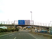
In Australia, a highway is a distinct type of road from freeways, expressways, and motorways
. The word highway is generally used to mean major roads connecting large cities, towns and different parts of metropolitan area
s. Metropolitan highways often have traffic lights at intersections, and rural highways usually have only one lane in each direction. The words freeway, expressway or motorway are generally reserved for the most arterial routes, usually with grade-separated intersections and usually significantly straightened and widened to a minimum of four lanes. The term motorway is used in some Australian cities to refer to freeways that have been allocated a metropolitan route number, and in Sydney, a motorway has a toll, whereas a freeway is free of charge. On the Hume Highway
when traveling from Melbourne
to Sydney there is only one set of traffic signals, found in Holbrook
. Roads may be part-highway and part-freeway until they are fully upgraded. The Cahill expressway is the only "named" expressway in New South Wales
, which opened in 1954 the first in New South Wales
.
, the Pan-European Corridor Vc
Motorway, Budapest
- Osijek
- Sarajevo
- Ploče
, is one of the most significant and project of the highest priority; in Bosnia and Herzegovina it coincides with A1 Motorway
. The construction works on the road have already begun, but intensified beginning of the construction will be a key starter of economic and social activities, and will enable Bosnia and Herzegovina
to be connected to main European traffic network, as well as to global European economic and social structure.
Construction of the motorway, whose total length is 340 km, will provide: rational connecting to neighboring countries and regions; stabilizing and developing effects will be reached; transport conditions and quality of life improvement; economy competitiveness enhancement; new projects launched and national and international private investments enhancement.
 In Brazil
, highways (or expressway/freeway
) are named "rodovia", and Brazilian highways are divided in two types: regional highways (generally of less importance and entirely inside of one state) and national highways (of major importance to the country). In Brazil, rodovia is the name given exclusively to roads connecting two or more cities with a sizable distance separating the extremes of the highway. Urban highways for commuting are uncommon in Brazil, and when they are present, they receive different names, depending of the region (Avenida, Marginal, Linha, Via, Eixo, etc.). Very rarely names other than "rodovia" are used.
Regional highways are named YY-XXX, where YY is the abbreviation of the state where the highway is running in and XXX is a number (e.g. SP-280; where SP means that the highway is running entirely in the state of São Paulo
).
National highways are named BR-XXX. National highways connects multiples states altogether, are of major importance to the national economy
and/or connects Brazil to another country. The meaning of the numbers are:
Often, Brazilian highways receive names (famous people, etc.) their YY/BR-XXX designation (example: SP-280 is also known as Rodovia Castelo Branco).
Since the Trans-Canada Highway is not a divided, multi-lane highway for the majority of its route, it is considered to be more of an equivalent to the U.S. Route highway network in the neighboring United States of America. On the other hand, Ontario's 400-series expressways, Quebec's autoroutes, New Brunswick's portion of the Trans-Canada, and Nova Scotia's 100-series highways are provincial equivalents to the Interstate Highway System
. The Canadian expressways interconnect with each other across provincial lines, and also with the American Interstate system. For example, expressways in Québec connect Montreal
with the American border, and thence Interstate 87
continues from there to New York City
, and likewise, Toronto
is connected to the border by Ontario expressways, and thence by Interstate 190 to Buffalo, New York
.
. , there were 3.98 million km of highways and 74,000 km of expressways in China; both total lengths are second only to the United States.
In Mainland China
, private companies reimbursed through tolls
are the primary means of creating and financing the National Trunk Highway System (NTHS).
Expressways are lumped with first-grade G-prefixed guódào (国道, or "national highway") or A-prefixed first-grade expressways in major municipal cities. All roads in the NTHS and most A-prefixed roads are expressways.
Some highways are numbered with a leading zero (e.g. G030).
The term Freeway during the 1990s was used on a few expressways (such as the Jingshi Freeway
). The term freeway has since been replaced with expressway on all signs in China. The Chinese name for expressways is uniform; in pinyin, it is gāosù gōnglù, which literally means "high speed public road".
Signs on the National Highways (G-prefix) are green, while on the lower-grade highways and urban expressways (A-prefix) are blue.
The most important projects under negotiation or construction are La Ruta del Sol (the Sun Road), a 4-lane highway between Bogota and the Caribbean coast; the Highway between Bogota and Buenaventura (Colombia's largest and busiest port) which includes a 9 km tunnel.
("Jutland
") and the major island of the east where the capital city of Copenhagen
is located. Also, there is now a bridge-tunnel that connects that major island with Sweden
and its highway system (and also its railroad system). Thus, it is now possible to drive from Denmark not only to Germany
, but to Sweden, too. Those bridge-tunnels are all interconnected within Denmark by major highways. These bridges, tunnels, and highways now make it possible to drive from northern Sweden to Gibraltar
at the southern edge of Spain
or to Messina, Italy
, at the southern tip of the Italian "boot".
). The chaussées constructed at this time, radiating out from Paris, form the basis for the "routes nationales" (RN), whose red numbers differ from the yellow numbering used for secondary "routes departementales". The RNs numbered from 1 to 20 radiate from Paris to major ports or border crossings. More recently (after the Second World War), France has constructed Autoroute
s, ex. A6-A7 which is call Autoroute du soleil, superhighways (usually toll
) with a speed limit of 130 km/h (110 in rainy conditions or urban areas).
has 7 major motorways ("autópálya"):
Also, there are other smaller motorway sections that will be linked to the national motorway network in the future. See here an animation of Hungarian motorway developments (past, present and future): "Térkép animáció".
Motorways usually have 2 traffic lanes and an emergency lane on each direction, divided by a green zone and metallic rail. The speed limit is 130 km/h.
Expressways usually have no dividing lane in the middle, but sometimes have a metallic rail. The number of lanes is one per direction, with sections of 1+2 lanes (for easier overtaking). The speed limit is 110 km/h. Motorways and expressways cannot be used by vehicles that are not able to reach 60 km/h. There is a toll on all motorways, except M0. Trucks and buses have a separate toll system. (http://www.motorway.hu/engine.aspx?page=prices2008)
Those who wish to travel on these roads have to buy a sticker. Controversially, there is no option to buy a one-day or one-time pass for passenger cars.
Main roads usually have one lane per direction, no dividing rail. The speed limit is 110 km/h.
County roads have less traffic then main roads, the speed limit is 90 km/h.
As of 2009, the major cities in India – Ahmedabad
, Pune
, Hyderabad
, Mumbai
, Chennai
, Kolkata
, and Delhi
– are connected by the Golden Quadrilateral
or North-South and East-West Corridor
, that consists of 4 to 6 laned roads. Other major cities are connected to it by the National Highways.
An expressway
refers to any access controlled road with grade-separated intersections and make up a very small portion of India's highway network, at about 1000 km in length. Expressways are separate from the highway network, except for the Delhi-Gurgaon Expressway
, which is part of NH 8.
has a similar system to the United Kingdom except that its major roads are classed as 'N' road or 'R' road rather than 'A' road/'B' road as in the UK.
 In Italy the term highway can be applied to superstrada (can be translated as expressway
and it is toll free) and autostrada (Italian term for motorway: the most part of the system it is mandatory toll). Italy was the first country in the world to build such roads, the first one being the "Autostrada dei Laghi" (Autostrada of the Lakes), from Milan
to Varese
, built in 1921 and finished in 1924. This system of early motorways was extended in the early 1930s till the early 1970s. Now days the Autostrade is a comprehensive system of about 6.500 km of modern motorways where the maximum speed limit is 130 km/h.
, or median. The speed limits, with certain regulations and great flexibility, usually include a maximum speed of 100 km/h, and a minimum speed of 50 km/h.
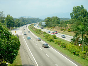 The highest level of major roads in Malaysia, expressway (lebuhraya)
, has full access control, grade separated junctions, and mostly tolled. The expressways link the major state capitals in Peninsular Malaysia
and major cities in Klang Valley
.
Highway is lower level with limited access control, some at-grade junctions or roundabouts, and generally with 2 lanes in each separated direction. These are generally untolled and funded by the federal government, hence the first one is called Federal Highway
linking Klang
and Kuala Lumpur
.
The trunk roads linking major cities and towns in the country are called federal trunk roads, and are generally 2 lanes single carriageway roads, in places with a third climbing lane for slow lorries.
In New Zealand, both motorway and an expressway
have at least two lanes of traffic in either direction separated by a median, with no access to adjacent properties. The distinction depends on the type of traffic allowed to use the route. Non-vehicular traffic and farm equipment are prohibited from motorways, while pedestrians, cyclists, tractors, and farm animals are legally entitled to use expressways such as the Waikato Expressway south of the Bombay Hills and the Tauranga expressway system, although this is rare. New Zealand's main routes are designated state highways as they are funded by the National Government. State Highway 1
is the only route to run through both the North and South Islands, and runs (in order north-south) from Cape Reinga
to Wellington
in the North Island
, and from Picton
to Bluff
in the South Island
. State Highways 2–5 are main routes in the North Island, State Highways 6–9 in the South Island, and state highways numbered from 10 onwards are generally found in numerical order from north to south. State highways usually incorporate different standards of roads, for example, State Highway 1 from Auckland
to Hamilton
incorporates the Northern and Southern Motorways in the Auckland area, the Waikato Expressway, and a rural road before passing through the streets of Hamilton. The term freeway is rarely used relating to New Zealand roads.
come more and more into practice, such as in a part of the A59 between Oss
and 's-Hertogenbosch. The Netherlands has the highest density highway network of Europe at 56.5 km per 1000 km², followed by Belgium. The 'Autosnelwegen', the main corridors, are designated with an A while the minor connecting roads have an N number. Sections of the A network are also part of the International E-road network
in connecting with neighboring Belgium, Germany and England, the latter by ferry
. The speed limit is 120 km/h, unless noted otherwise, and 100 km/h or 80 km/h on various locations. This is done to "protect the environment" and to limit noise to surrounding residential areas, albeit not too effective a measure.
Norway has a national highway system, numbered 2-899. Some main highways are also European highways and have an E before the number. The highways are often relatively narrow and curvy. Near the larger cities, especially around Oslo and Trondheim, there are motorways. Norway has also been engaged in recent decades in boring some extremely long highway tunnels through the mountain ranges, and some of these, now the world's longest, are so long that they have hollowed-out caverns in the midst of them for motorists to stop and take rests.
Pakistan has its own network of highways and motorways. Motorways extending from M1 to M10 will eventually connect whole length of the country from Peshawar to Karachi. The M2, the first motorway, was built in 1997 with the contract being awarded to the Korea
n firm Daewoo
. It linked the federal capital Islamabad
with Punjab
's provincial capital Lahore
. The network was then extended to Sargodha
and then to Faisalabad
with the M3. M1 highway to the North-West Frontier Province
's capital Peshawar
had been completed in October 2007. M4, M5, M6, and M7 have been planned and also being built by local and foreign firms. This will connect Faisalababd, Multan, Dera Ghazi Khan, Rotadero (Larkana) to Karachi. N5 links Karachi
to other cities.
Entry on all Pakistan highways is restricted to fast moving wheelers only. Slow-moving traffic and two wheelers (such as motorcycles and bicycles) are not allowed and construction and agricultural machinery is also restricted. Highway Police personnel use heavy motor bikes and fast moving Range Rovers for patrolling and are quite good at maintaining the traffic system. M9 and M10 are also functional now that connect Karachi to Hayderabad. The LSM (Lahore Sialkot Motorway) which is 103 km is under construction and will be completed by 2010.
. They follow the US Interstate Highway Standards and speed limits are strictly enforced. The most modern and the longest expressway, the North Luzon Expressway
links the capital, Manila to other provinces in Northern Luzon while the South Luzon Expressway
links Manila with provinces on the Southern Luzon.
Presently, all Philippine expressways are under rehabilitation to decrease the occurrence of traffic jams and to improve their quality. They are widened and improved of standards.
There are only seven tollways in Luzon Island, the North Luzon Expressway (connecting Manila to North Luzon), the South Luzon Expressway (connecting Manila to Southern Luzon), the Roman Expressway (in Bataan peninsula), Subic Freeport Expressway (connecting Subic Freeport to Dinalupihan), the Southern Tagalog Access Road (STAR Tollway) (connecting Sto. Tomas to Batangas Port, to decongest the Port of Manila and it will be connected directly to South Luzon Expressway), and the Manila-Cavite Expressway, connecting Metro Manila with the Province of Cavite, Subic-Clark-Tarlac Expressway (connecting the existing Subic Freeport Expressway to Clark Zone and Hacienda Luisita and also extending North Luzon Expressway to Tarlac City but it has 3 km gap between NLEx and SCTEx).
Despite that many highways in Metro Manila, there are still two lane and one way roads like national and provincial roads around the country.
There are plans to extend the existing expressways and to build a new one throughout the Philippines, the Tarlac-La Union Expressway aims to extend North Luzon Expressway to the area near Poro Point but it will be extended initially to Rosario in La Union, Tarlac-Dingalan Expressway aims to convert Dingalan into an International Pacific Port and to decongest the Port of Manila, The Cebu Trans-Axial Expressway aims to benefit Cebu's economy and to decongest the island's coastal road and to protect Cebu's coastal areas from severe exploitation, North East Luzon Expressway aims to connect Metro Manila to Cagayan Valley but it will be built initially to Nueva Ecija. South Luzon Expressway will be extended towards Lucena City.
members. They are now being extended and additionally, another three motorways are planned to be built by 2016.
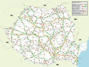
for using the motorways in Romania, except Cernavodă Bridge over the Danube on the A2. Nevertheless, every car that uses a motorway or a national road in Romania must wear a sticker called a rovinietă on its windscreen, which can be bought at larger petrol stations.
and Saint Petersburg
Ring Roads. Highways and motorways are free in Russia
and only two motorways, Western High Speed Diameter
and Moscow-Saint Petersburg toll motorway, currently under construction, will be first Russian toll motorways. Russians themselves often translate the Russian name for highway (Автомобильные дороги=automobile roads) into motorway in English, which is not a correct English name.
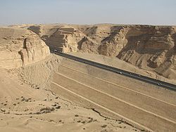 Saudi Arabia has a total highway length of 173,000 km. Highways in Saudi Arabia vary from ten laned roads to small four laned roads. The city highways and other major highways are well maintained such as the roads in Riyadh
. The roads are constructed so they resist the summer's extremely high heat and do not reflect the strong sun. The outer city highways such as the one linking from coast to coast are not as great as the inner-city highways but the government is now working on rebuilding those roads.
Some of the important inter-city highways include:
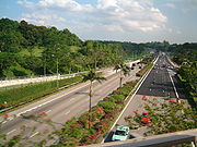 The expressways of Singapore are all dual carriageways with grade-separated access. They usually have three lanes in each direction, although there are two- or four-lane carriageways in some places. There are nine expressways, with another one, the Marina Coastal Expressway
, currently under construction.
Construction on the first expressway, the Pan Island Expressway
, started in 1966. The other expressways were completed in stages, with the first phase of the Kallang-Paya Lebar Expressway
being the most recently completed, in 2007. Today, there are 92.5 miles (148.9 km) of expressways in Singapore.
with limited access, and at least two lanes in either direction. A central island, usually either with drainage, foliage, or high-impact barriers, provides a visible separation between the carriageways in opposite directions. As in the United Kingdom, Ireland, Australia, and Japan, South Africans drive on the left-hand side of the road and nearly all steering wheels are on the right-hand side of vehicles.
Freeways are designated with one of three labels: N (in reference to national roads), R (short for "route", in reference to provincial roads), and M (in reference to metropolitan roads). This has more to do with the location of a road and its function than anything else. In addition, "N" roads usually run the length of the country over long distances, "R" roads usually inter-connect cities and towns within a province, and "M" roads carry heavy traffic in metropolitan areas. Route markings also determine who paid for the road: "N" was paid for by national government, "R" by provincial government, and "M" by local government. In recent years, some "R" roads have been re-designated as "N" roads, so that control and funding comes from the South African National Roads Agency.
in the United States:
 Spain's national highway system dates back to the era of King Carlos III. The roads built at this time, radiating from Madrid
, form the basis for the carreteras nacionales radiales, numbered clockwise from I to VI, which radiate from Madrid
to major ports or border crossings. In the 1960s Spain started to construct autopistas (toll highways) and autovías (freeways), and in 2007 had 14,689 km of highways, the biggest network in Europe and the third in the world, only after the USA and China
.
Southern Expressway is the first expressway in Sri Lanka and it is an important link of the proposed expressway network. It travers from Kottawa to Matara (126 km) and the construction of the section from Kottawa to Pinnaduwa (Galle) has been completed as a dual Expressway with 4-lane facility. Galle Port access road has been built to connect Galle city to Pinnaduwa interchange.
The design speed of the Expressway is 120km/h. The operation speed of the Expressway is 100km/h.
The Southern Expressway will be extended up to Hambantota connecting Mattala Airport which is being constructed.
was built between the cities of Malmö and Lund in the Skåne County in southern Sweden. The Swedish roads are divided in three classes; Motorväg, which is a 4-8 lane motorway with the speed limit of 110–120 km/h. Riksväg, which is a state highway with 2-4 lanes. The Riksväg has a speed limit of 70–100 km/h. The last road is the Länsväg, which is a "county route" with 2 lanes and 70–90 km/h in speed limit. The authority which is responsible for the roads in Sweden is Vägverket.
(French) / Autostrada (Italian) is used for normal highways where there is a central physical structure separating two different directional carriageways. This is often translated into English as motorways.
In express routes where there is no central physical structure separating two different directional carriageways, but crossings are still motorway-like otherwise, and traffic lights are not present, the road is instead called an Autostrasse / Semi-autoroute / Semi-autostrada, usually translated into English as an expressway. Those often have a lower speed limit than motorways.
. The Northern section between Keelung City and Zhongli City was completed in 1974. The construction of the first freeway (No. 1) was completed in 1978. The freeway runs from the northern port city cf Keelung
to the southern port city of Kaohsiung
. There was an 8.6 km branch (No. 1A) connecting the Taiwan Taoyuan International Airport.
Construction on the other freeways began in the late 1980s. The north section of the second north-south freeway (No. 3) between Xizhi City and Hsinchu City was completed in 1997. The No. 1A Branch was extended to link No. 3 Freeway at Yingge, and renamed as No. 2 Freeway. Three other short freeways (No. 4, No. 8, and No. 10) were built to link the two north-south freeways in Taichung County
(now part of Taichung City), Tainan County
(now part of Tainan City), and Kaohsiung County
(now part of Kaohsiung City), respectively. The entire No. 3 Freeway was completed in January, 2004.
To ease the congestion of No. 1 Freeway in the Taipei metropolitan area, a 20 km elevated bridge was built in 1997 on top of the original freeway between Xizhi City and Wugu
, to serve as a bypass for traffic not exiting/entering the freeway within the city limits of Taipei.
The construction of a freeway connecting the Taipei metropolitan area and Yilan County began in 1991 and was completed in June 2006. It includes a 12.9 km tunnel (Hsuehshan Tunnel
), which is the fifth longest road tunnel
in the world. An extension from Yilan County to Hualian County is planned. However, its construction is being delayed due to environmental concerns.
to the capital Ankara
.
, 'A' road / 'B' road, 'C' road, and unclassified road; they may additionally, where appropriate, be described as dual carriageway
s. However, in the law of England and Wales
the term public highway includes all public rights of way regardless of the kind or amount of traffic they allow, including streets and public footpaths for pedestrians. The term also includes bridleways, which are for pedestrians, equestrians, and cyclists, as well as by-ways open to all traffic (for all of those users, plus vehicular traffic).
In England and Wales, the public is said to have a "right of way" over a highway. This means that, subject to statutory restrictions, the route (or "way") must be kept clear to allow travel by anyone who wishes to it. At common law
, it is unlawful to obstruct a highway or to interfere with its lawful use. However, many statutory provisions provide powers to do so (for instance. to carry out roadwork).
Many public highways in the UK have a private owner. That is, someone can prove "title" to them, either by being the registered owner or by having conveyances showing exactly how the land has been bought and sold over a long period of time. Such ownership in no way affects the public highway rights, since the relevant "highway authority" (usually a local authority or the Highways Agency
in England and Wales, or Amey Highways in Scotland
) is deemed to own the surface of the highway, despite someone else's ownership of the land it passes over or under.
However, the understanding in some places is that if the road or highway is ever permanently closed and demolished, then complete control of the strip of land on which it lies reverts to the actual owner of the land. In other places, the word "easement" is used. The governmental authority has an indefinitely long easement to use the strip of land for a road, but if the road vanishes, so does the easement that goes with it. It is possible that sometime in the far future, roads and highways will become obsolete, with people and cargo getting from here to there by some other means. Thus, some of the statements below are short-sighted and questionable.
Rights-of-way exist over all highways maintained at the public expense (the majority of roads) and also over some other ways which are not so maintained, on the principle of "once a highway, always a highway". In such cases, landowners must allow public use for "passing and repassing".
A right-of-way may be created by custom (by the way being used for a long period of time) or under the relevant Sections of the Highways Act of 1980. A right-of-way may be extinguished or diverted in a number of ways, such as by an Act of Parliament, by a magistrate
s' stopping-up or diversion order, or by powers given to principal local authorities. For instance, under the Channel Tunnel Rail Link Act of 1996, authority was given for the builder of this railway link to stop up certain highways that are mentioned in Schedule 3 of the act.
The opposite of a highway is a private road or pathway over which no rights-of-way exist. Any use of such private ways is subject to the consent of the owner of the land.
Richard Mabey poses the origin of the word "highway" back to the Romans in his book "The Roadside Wildlife Book", 1974: "Daniel Defoe, writing in the 1720s, describes the Fosse Way as being raised eight or nine feet in many places. Between AD 40 and 80, the Romans laid something like 6,500 miles of highway. (Were these raised roads one origin of this word?)".
 In the United States, "highway" is a general term for denoting a public way, including the entire area within the right-of-way, and includes many forms:
Note that the phrase "right-of-way" is used differently in the United States than it is in the United Kingdom and certain other places. In the U.S. a highway or road "right-of-way" means the land on which the pavement rests, plus the shoulders beside the pavements, plus any median strip, plus any other adjacent piece of land that is designated for the purposes of the highway or road. In other words, the "right-of-way" is the strip of land for the highway or road, and a sign that say, "No Parking on Right-of-Way" means just that: don't park on the pavement or on the land adjacent to it.
Many paved highways for vehicles are part of the official National Highway System of the U.S.
. Paved highways in the "U.S. Highway" system (for example, U.S. Highway 50) can vary from two lanes wide (one lane each direction), shoulderless, roads with no access control, to multi-lane high-speed controlled-access highway, such as the Interstate Highways. These roads are usually distinguished by being important, but not always the primary, routes that connect populated areas. (Sometimes, the primary route is a State Highway.) Since their inception many decades ago, the construction of "U.S. Highways", and their major improvements, have been paid for 50% with Federal funds, especially from motor fuel taxes, and 50% with State funds from whatever tax resources that the state has. Thus, the system of "U.S. Highways" has always been an equal partnership between the Federal Government and the State governments. This was a plan that changed dramatically with the advent of the Interstate Highway system beginning in the 1950s, but do not forget that the system of "U.S. Highways" continued to be upgraded under the 50%-50% funding. Highways continue to be widened, old bridges continue to be replaces with newer and better ones, and so forth.
The term "Highways" in the U.S. even includes major paved roads that serve purposes similar to those of the U.S. Highways or Interstate Highways, but which are completely designed, paid for, and maintained by state or local governments. An example of this is Tennessee Highway 840, which is a long, partially completed "urban bypass" of Nashville, Tenn. that is a multi-lane, controlled-access highway entirely designed and paid for by Tennessee
. Much of the traffic on it will eventually come from Interstate 40
, completely avoid the big city, and then return to Interstate 40. Incidentally, Tennessee-840 also has connections with Interstate 24
and Interstate 65
, where both of the freeway interchanges are already finished, as well as the eastern interchange with Interstate 40.
When the Act of Congress that authorized the Interstate Highway System
was passed and then signed by President Eisenhower
, it was already clear that the Interstate Highways would be far more expensive, mile-for-mile, than the U.S. Highways had been. Also, the Interstate Highways were to be built largely, for the purposes of constitutionality, for Federal purposes which were,
A. To promote and enable the National Defense by being able to move very large numbers of troops, and their equipment and supplies from place to place, rapidly, by truck and bus. Also, long stretches of the expressway would have the capability of functioning as emergency take-off and landing strips for Air Force planes in wartime.
B. To promote and enable commerce between the 48 states that existed then, under the Interstate Commerce Clause
of the Constitution
With these being the stated purposes of the Interstate Highways (and also the source of the name "Interstate Highway", from the Commerce Clause), and because of their great cost, Congress decided to set the standard for Federal funding for the Interstate System at 90%, leaving 10% for the States to pay for.
Another monetary difference came from the fact that the Interstate Highways were to be designed to be high-speed and safe expressways. This meant that they needed to have much wider open strips of land along their sides, because this created safety zones on each side of the highways so that vehicles that were in accidents or simply lost control would have somewhere to go, to slow down gradually, and not crash into trees, boulders, light poles, buildings, parked vehicles, fire hydrants, and other kinds of obstacles that you can think of. Roadway interchanges for Interstate Highways were also to be very large (and over the decades, they became a lot larger than anyone had anticipated in the 1950s). With so much land being taken away for the highways, the only way to justify it and to make it politically palatable was for the Federal and State governments to outright purchase all of the land. There could be no question of just having an easement
for the highway and its right-of-way. All of the land within the right-of-way would be permanently owned by the governments, until such time that they decided to get rid of the highway and sell the land.
In some places, "highway" is a synonym for "road" or "street", and in some cases, the word "highway" is simply used in cases of carelessness and laziness on the part of the speaker, who believes that "street", "road", and "highway" are all synonymous and uses them accordingly. On the other hand, in another example, the California Motor Vehicle Code § 360 states: "'Highway' is a way or place of whatever nature, publicly maintained and open to the use of the public for purposes of vehicular travel. Highway includes street." The California Supreme Court has held that "the definition of 'highway' in the Vehicle Code is used for special purposes of that act," and that canals of the town of Venice, California, are "highways" also entitled to be maintained with state highway funds.
The Federal and State governments are trying to improve their national highway systems by repaving highways, widening highways, replacing bridges, and reconstructing some interchanges. Many cloverleaf interchange
s are being converted to parclo interchanges. Busy Diamond interchange
s are also being converted to SPUI
s (single-point-urban interchange) or to parclos to reduce interchange congestion.
Arguably, the most famous United States highway is U.S. Route 66
. It is immortalized in the song (Get Your Kicks On) Route 66
, and by the legendary TV series Route 66
. Other famous highways in songs include Highway 61 (Bob Dylan, 1965), Carefree Highway in Arizona (Gordon Lightfoot, 1974), Colorado Boulevard in Pasadena, California (Jan & Dean, also Beach Boys, 1964), the song Ventura Highway
, named for a highway in Southern California ("America", 1972), and Blues Highway in Mississippi (Fred McDowell, 1959).
Country
A country is a region legally identified as a distinct entity in political geography. A country may be an independent sovereign state or one that is occupied by another state, as a non-sovereign or formerly sovereign political division, or a geographic region associated with a previously...
describes the highway
Highway
A highway is any public road. In American English, the term is common and almost always designates major roads. In British English, the term designates any road open to the public. Any interconnected set of highways can be variously referred to as a "highway system", a "highway network", or a...
systems available in selected countries.
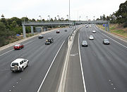
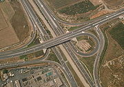
Australia
In Australia, a highway is a distinct type of road from freeways, expressways, and motorways
Controlled-access highway
A controlled-access highway is a highway designed exclusively for high-speed vehicular traffic, with all traffic flow and ingress/egress regulated...
. The word highway is generally used to mean major roads connecting large cities, towns and different parts of metropolitan area
Metropolitan area
The term metropolitan area refers to a region consisting of a densely populated urban core and its less-populated surrounding territories, sharing industry, infrastructure, and housing. A metropolitan area usually encompasses multiple jurisdictions and municipalities: neighborhoods, townships,...
s. Metropolitan highways often have traffic lights at intersections, and rural highways usually have only one lane in each direction. The words freeway, expressway or motorway are generally reserved for the most arterial routes, usually with grade-separated intersections and usually significantly straightened and widened to a minimum of four lanes. The term motorway is used in some Australian cities to refer to freeways that have been allocated a metropolitan route number, and in Sydney, a motorway has a toll, whereas a freeway is free of charge. On the Hume Highway
Hume Highway
The Hume Highway/Hume Freeway is one of Australia's major inter-city highways, running for 880 km between Sydney and Melbourne. It is part of the Auslink National Network and is a vital link for road freight to transport goods to and from the two cities as well as serving Albury-Wodonga and...
when traveling from Melbourne
Melbourne
Melbourne is the capital and most populous city in the state of Victoria, and the second most populous city in Australia. The Melbourne City Centre is the hub of the greater metropolitan area and the Census statistical division—of which "Melbourne" is the common name. As of June 2009, the greater...
to Sydney there is only one set of traffic signals, found in Holbrook
Holbrook, New South Wales
Holbrook is a small town in Southern New South Wales, Australia. It is on the Hume Highway, 356 km North-East of Melbourne and 491 km south-west of Sydney between Tarcutta and Albury. The town is in the Greater Hume Shire Council area which was established in May 2004 from the merger of...
. Roads may be part-highway and part-freeway until they are fully upgraded. The Cahill expressway is the only "named" expressway in New South Wales
New South Wales
New South Wales is a state of :Australia, located in the east of the country. It is bordered by Queensland, Victoria and South Australia to the north, south and west respectively. To the east, the state is bordered by the Tasman Sea, which forms part of the Pacific Ocean. New South Wales...
, which opened in 1954 the first in New South Wales
New South Wales
New South Wales is a state of :Australia, located in the east of the country. It is bordered by Queensland, Victoria and South Australia to the north, south and west respectively. To the east, the state is bordered by the Tasman Sea, which forms part of the Pacific Ocean. New South Wales...
.
Belgium
Belgium has the highest density highway network of Europe following The Netherlands at 54.7 km per 1000 km². Most of its highways have three lanes with a few exceptions like the ring-roads around Brussels and Antwerp which have five or six lanes in various stretches. Belgium is situated at a crossroads of several different countries, and its highways are used by people of many nationalities. In Belgium the highways are indicated by the letter "A" and an E(uropean) number. The E numbers are used most often. Roads that are (part of) a ring-road around a city or a town are usually indicated by an R number. Many of the highways in Belgium are illuminated at night, since there is a surplus of nuclear electric power during the off-peak hours.Bosnia and Herzegovina
As for Bosnia and HerzegovinaBosnia and Herzegovina
Bosnia and Herzegovina , sometimes called Bosnia-Herzegovina or simply Bosnia, is a country in Southern Europe, on the Balkan Peninsula. Bordered by Croatia to the north, west and south, Serbia to the east, and Montenegro to the southeast, Bosnia and Herzegovina is almost landlocked, except for the...
, the Pan-European Corridor Vc
Corridor Vc
The European route E 73 is a Class-A north-south European route that connects the central part of the continent, specifically Hungary and eastern Croatia to Bosnia and Herzegovina and the Adriatic Sea in the area of the port of Ploče. This route is also designated as the Pan-European Corridor...
Motorway, Budapest
Budapest
Budapest is the capital of Hungary. As the largest city of Hungary, it is the country's principal political, cultural, commercial, industrial, and transportation centre. In 2011, Budapest had 1,733,685 inhabitants, down from its 1989 peak of 2,113,645 due to suburbanization. The Budapest Commuter...
- Osijek
Osijek
Osijek is the fourth largest city in Croatia with a population of 83,496 in 2011. It is the largest city and the economic and cultural centre of the eastern Croatian region of Slavonia, as well as the administrative centre of Osijek-Baranja county...
- Sarajevo
Sarajevo
Sarajevo |Bosnia]], surrounded by the Dinaric Alps and situated along the Miljacka River in the heart of Southeastern Europe and the Balkans....
- Ploče
Ploce
Ploče is a town and a notable seaport in the Dubrovnik-Neretva County of Croatia.The total population of Ploče is 10,102 , in the following settlements:* Baćina, population 564* Banja, population 176* Komin, population 1,222...
, is one of the most significant and project of the highest priority; in Bosnia and Herzegovina it coincides with A1 Motorway
A1 (Bosnia and Herzegovina)
thumb|A1's projected routeThe A1 motorway is a motorway in Bosnia and Herzegovina that is part of the Corridor Vc and, together with two Croatian motorways and the Hungarian M6, will provide a modern and fast road connection from Budapest to Ploče, an important seaport on the Adriatic Sea.The...
. The construction works on the road have already begun, but intensified beginning of the construction will be a key starter of economic and social activities, and will enable Bosnia and Herzegovina
Bosnia and Herzegovina
Bosnia and Herzegovina , sometimes called Bosnia-Herzegovina or simply Bosnia, is a country in Southern Europe, on the Balkan Peninsula. Bordered by Croatia to the north, west and south, Serbia to the east, and Montenegro to the southeast, Bosnia and Herzegovina is almost landlocked, except for the...
to be connected to main European traffic network, as well as to global European economic and social structure.
Construction of the motorway, whose total length is 340 km, will provide: rational connecting to neighboring countries and regions; stabilizing and developing effects will be reached; transport conditions and quality of life improvement; economy competitiveness enhancement; new projects launched and national and international private investments enhancement.
Brazil
Brazil
Brazil , officially the Federative Republic of Brazil , is the largest country in South America. It is the world's fifth largest country, both by geographical area and by population with over 192 million people...
, highways (or expressway/freeway
Controlled-access highway
A controlled-access highway is a highway designed exclusively for high-speed vehicular traffic, with all traffic flow and ingress/egress regulated...
) are named "rodovia", and Brazilian highways are divided in two types: regional highways (generally of less importance and entirely inside of one state) and national highways (of major importance to the country). In Brazil, rodovia is the name given exclusively to roads connecting two or more cities with a sizable distance separating the extremes of the highway. Urban highways for commuting are uncommon in Brazil, and when they are present, they receive different names, depending of the region (Avenida, Marginal, Linha, Via, Eixo, etc.). Very rarely names other than "rodovia" are used.
Regional highways are named YY-XXX, where YY is the abbreviation of the state where the highway is running in and XXX is a number (e.g. SP-280; where SP means that the highway is running entirely in the state of São Paulo
São Paulo (state)
São Paulo is a state in Brazil. It is the major industrial and economic powerhouse of the Brazilian economy. Named after Saint Paul, São Paulo has the largest population, industrial complex, and economic production in the country. It is the richest state in Brazil...
).
National highways are named BR-XXX. National highways connects multiples states altogether, are of major importance to the national economy
Economic system
An economic system is the combination of the various agencies, entities that provide the economic structure that defines the social community. These agencies are joined by lines of trade and exchange along which goods, money etc. are continuously flowing. An example of such a system for a closed...
and/or connects Brazil to another country. The meaning of the numbers are:
- 001-100 - it means that the highway runs radially from BrasíliaBrasíliaBrasília is the capital city of Brazil. The name is commonly spelled Brasilia in English. The city and its District are located in the Central-West region of the country, along a plateau known as Planalto Central. It has a population of about 2,557,000 as of the 2008 IBGE estimate, making it the...
. It is an exception to the cases below. - 101-200 - it means that the highway runs in a south-north way.
- 201-300 - it means that the highway runs in a west-east way
- 301-400 - it means that the highway runs in a diagonal way (northwest-southeast, for example)
- 400-499 - another exception, they are less important highways and its function is to connect a city to an arterial highway nearby
Often, Brazilian highways receive names (famous people, etc.) their YY/BR-XXX designation (example: SP-280 is also known as Rodovia Castelo Branco).
Canada
- In Canada, there is no national standard for nomenclature, although in non-technical contexts highway appears to be most popular in most areas. The general speed limits on most Canadian highways range between 80 and 110 km/h (49.7 and 68.4 mph) on two-lane highways, and between 90 and 110 km/h (55.9 and 68.4 mph) on multi-lane, divided highways.
- Canada is the second largest country in the world in terms of land area, though it only has 1350581 kilometres (839,214.2 mi) of paved roads. This is far less highway and road distance than the United StatesUnited StatesThe United States of America is a federal constitutional republic comprising fifty states and a federal district...
, which is smaller, but has more than 6,000,000 kilometers of paved roads and highways. However, Canada still has many more roads and highways than Russia, the largest country in the world in land area, with an estimated just 336,000 kilometers (208,000 miles) of paved roads. - The most extensive freeway network in Canada is in the well-populated southeastern Canada, linking southern OntarioSouthern OntarioSouthern Ontario is a region of the province of Ontario, Canada that lies south of the French River and Algonquin Park. Depending on the inclusion of the Parry Sound and Muskoka districts, its surface area would cover between 14 to 15% of the province. It is the southernmost region of...
, southern QuebecQuebecQuebec or is a province in east-central Canada. It is the only Canadian province with a predominantly French-speaking population and the only one whose sole official language is French at the provincial level....
, Nova ScotiaNova ScotiaNova Scotia is one of Canada's three Maritime provinces and is the most populous province in Atlantic Canada. The name of the province is Latin for "New Scotland," but "Nova Scotia" is the recognized, English-language name of the province. The provincial capital is Halifax. Nova Scotia is the...
, New BrunswickNew BrunswickNew Brunswick is one of Canada's three Maritime provinces and is the only province in the federation that is constitutionally bilingual . The provincial capital is Fredericton and Saint John is the most populous city. Greater Moncton is the largest Census Metropolitan Area...
, and the United States. This makes the freeway network there very well-traveled, requiring these routes to be well-maintained to overcome the frequently harsh winter weather, and also wide enough to accommodate the high traffic volumes that they carry in large metropolitan areas, such as around TorontoTorontoToronto is the provincial capital of Ontario and the largest city in Canada. It is located in Southern Ontario on the northwestern shore of Lake Ontario. A relatively modern city, Toronto's history dates back to the late-18th century, when its land was first purchased by the British monarchy from...
, MontrealMontrealMontreal is a city in Canada. It is the largest city in the province of Quebec, the second-largest city in Canada and the seventh largest in North America...
, OttawaOttawaOttawa is the capital of Canada, the second largest city in the Province of Ontario, and the fourth largest city in the country. The city is located on the south bank of the Ottawa River in the eastern portion of Southern Ontario...
, and Detroit, to prevent the economical problems and frustrations that result from heavy traffic congestionTraffic congestionTraffic congestion is a condition on road networks that occurs as use increases, and is characterized by slower speeds, longer trip times, and increased vehicular queueing. The most common example is the physical use of roads by vehicles. When traffic demand is great enough that the interaction...
, and also be safe enough to reduce the number of vehicle accidents. - In OntarioOntarioOntario is a province of Canada, located in east-central Canada. It is Canada's most populous province and second largest in total area. It is home to the nation's most populous city, Toronto, and the nation's capital, Ottawa....
, all public roads are legally defined as highways, though provincially managed roads are known legally as Provincial Highways. In day-to-day usage, the term highway is used for provincial routes or freeways. It is also common for surface routes to be referred to by number (e.g. "Take Number 10Highway 10 (Ontario)King's Highway 10, commonly referred to as Highway 10 and historically as the Toronto–Sydenham Road, is a provincially maintained highway in the Canadian province of Ontario...
from Mississauga to Owen SoundOwen Sound, OntarioOwen Sound , the county seat of Grey County, is a city in Southern Ontario, Canada...
"), especially by older generations. The words freeway or expressway are sometimes used to refer to controlled-access, high-speed, grade-separated highways such as the 400-series highways400-series highways (Ontario)The 400-series highways are a network of controlled-access highways throughout the southern portion of the Canadian province of Ontario, forming a special subset of the provincial highway system. They are analogous to the Interstate Highway System in the United States or the British Motorway...
, the Gardiner ExpresswayGardiner ExpresswayThe Frederick G. Gardiner Expressway, colloquially referred to as "the Gardiner", is a municipal expressway in the Canadian province of Ontario, connecting downtown Toronto with its western suburbs...
, the Don Valley ParkwayDon Valley ParkwayThe Don Valley Parkway is a controlled-access six-lane municipal expressway in Toronto connecting the Gardiner Expressway in downtown Toronto with Ontario Highway 401, the Macdonald–Cartier Freeway. North of Highway 401, it continues as Ontario Highway 404. The parkway runs through...
, the Conestoga ParkwayConestoga ParkwayThe Conestoga Parkway is a freeway in the Regional Municipality of Waterloo, in the Canadian province of Ontario. It runs northeast/southwest through the cities of Kitchener and Waterloo, and is connected to Highway 401 via the Highway 8 Freeport Diversion and King Street East.- Route...
, or the E.C. Row Expressway. The only highway officially labeled as a freeway is the Macdonald-Cartier Freeway, usually known as Highway 401, or simply "the 401", which is North America's busiest freeway, as well as one of the widest in the world at 18 through lanes. Nearly all highways in OntarioOntarioOntario is a province of Canada, located in east-central Canada. It is Canada's most populous province and second largest in total area. It is home to the nation's most populous city, Toronto, and the nation's capital, Ottawa....
use parclo interchangeParclo interchangeA partial cloverleaf interchange or parclo is a modification of a cloverleaf interchange. The parclo interchange was developed by the Ontario Ministry of Transportation as a replacement for the cloverleaf on 400-Series Highways, removing the dangerous weaving patterns and allowing for more...
s, which were developed by the province. Parclos are used to avoid weaving and to maximize efficiency and safety. - In QuebecQuebecQuebec or is a province in east-central Canada. It is the only Canadian province with a predominantly French-speaking population and the only one whose sole official language is French at the provincial level....
, major highwaysControlled-access highwayA controlled-access highway is a highway designed exclusively for high-speed vehicular traffic, with all traffic flow and ingress/egress regulated...
are called autoroutes in French, and expressways or autoroutes in English. - Nova ScotiaNova ScotiaNova Scotia is one of Canada's three Maritime provinces and is the most populous province in Atlantic Canada. The name of the province is Latin for "New Scotland," but "Nova Scotia" is the recognized, English-language name of the province. The provincial capital is Halifax. Nova Scotia is the...
numbers its highways by the trunk routes they parallel. For example, Highway 107Nova Scotia Highway 107Highway 107 in Nova Scotia runs through the eastern suburbs of the Halifax Regional Municipality, from the Burnside Industrial Park in Dartmouth to an intersection with Trunk 7 in Musquodoboit Harbour. It is long, and is mostly two lanes and controlled access....
parallels Trunk 7. This, to a lesser extent, also applies in Ontario (e.g. Highway 410 and Highway 420 parallel Highway 10Highway 10 (Ontario)King's Highway 10, commonly referred to as Highway 10 and historically as the Toronto–Sydenham Road, is a provincially maintained highway in the Canadian province of Ontario...
and Highway 20Highway 20 (Ontario)King's Highway 20, also known as Highway 20, is a provincially maintained highway in the Canadian province of Ontario. Presently, it is a short stub between Highway 58 and Niagara Regional Road 70 in the town of Thorold.- History :...
.) Nova Scotia also numbers its highways according to usage: main arterial highways are in the 100s, secondary or old arterial highways are numbered in the double digits from 1 to 28, and collector roadCollector roadA collector road or distributor road is a low to moderate-capacity road which serve to move traffic from local streets to arterial roads. Unlike arterials, collectors are also designed to provide access to residential properties...
s are numbered in the triple digits starting at 200. - The Trans-Canada HighwayTrans-Canada HighwayThe Trans-Canada Highway is a federal-provincial highway system that joins the ten provinces of Canada. It is, along with the Trans-Siberian Highway and Australia's Highway 1, one of the world's longest national highways, with the main route spanning 8,030 km...
(or Trans-Canada) is a highway that crosses all of Canada from east to west and enters all ten provinces. The actual Trans-Canada ranges from a two-lane highway across the Great Plains and the Rocky Mountains to a multi-lane urban expressway. There are three or more ferry routes along the Trans-Canada, which allows the it to connect to Newfoundland, Prince Edward IslandPrince Edward IslandPrince Edward Island is a Canadian province consisting of an island of the same name, as well as other islands. The maritime province is the smallest in the nation in both land area and population...
, and Vancouver IslandVancouver IslandVancouver Island is a large island in British Columbia, Canada. It is one of several North American locations named after George Vancouver, the British Royal Navy officer who explored the Pacific Northwest coast of North America between 1791 and 1794...
. However the comparatively new Confederation BridgeConfederation BridgeThe Confederation Bridge is a bridge spanning the Abegweit Passage of Northumberland Strait, linking Prince Edward Island with mainland New Brunswick, Canada. It was commonly referred to as the "Fixed Link" by residents of Prince Edward Island prior to its official naming. Construction took place...
allows driving from New Brunswick to Prince Edward Island without using a ferry. (Ferries do connect this Island to Quebec, where the main Trans-Canada route is.)
Since the Trans-Canada Highway is not a divided, multi-lane highway for the majority of its route, it is considered to be more of an equivalent to the U.S. Route highway network in the neighboring United States of America. On the other hand, Ontario's 400-series expressways, Quebec's autoroutes, New Brunswick's portion of the Trans-Canada, and Nova Scotia's 100-series highways are provincial equivalents to the Interstate Highway System
Interstate Highway System
The Dwight D. Eisenhower National System of Interstate and Defense Highways, , is a network of limited-access roads including freeways, highways, and expressways forming part of the National Highway System of the United States of America...
. The Canadian expressways interconnect with each other across provincial lines, and also with the American Interstate system. For example, expressways in Québec connect Montreal
Montreal
Montreal is a city in Canada. It is the largest city in the province of Quebec, the second-largest city in Canada and the seventh largest in North America...
with the American border, and thence Interstate 87
Interstate 87
Interstate 87 is a Interstate Highway located entirely within New York State in the United States of America. I-87 is the longest intrastate Interstate highway in the Interstate Highway System. Its southern end is at the Bronx approaches of the Robert F. Kennedy Bridge in New York City...
continues from there to New York City
New York City
New York is the most populous city in the United States and the center of the New York Metropolitan Area, one of the most populous metropolitan areas in the world. New York exerts a significant impact upon global commerce, finance, media, art, fashion, research, technology, education, and...
, and likewise, Toronto
Toronto
Toronto is the provincial capital of Ontario and the largest city in Canada. It is located in Southern Ontario on the northwestern shore of Lake Ontario. A relatively modern city, Toronto's history dates back to the late-18th century, when its land was first purchased by the British monarchy from...
is connected to the border by Ontario expressways, and thence by Interstate 190 to Buffalo, New York
Buffalo, New York
Buffalo is the second most populous city in the state of New York, after New York City. Located in Western New York on the eastern shores of Lake Erie and at the head of the Niagara River across from Fort Erie, Ontario, Buffalo is the seat of Erie County and the principal city of the...
.
Chile
Chile has a large Highway coverage which connects the whole country but with the exception of the Magallanes Region.China, People's Republic
"Highways" in China, more often than not, refer to China National Highways. The fully controlled-access, multi-lane, divided routes are instead called expresswaysExpressways of China
The Expressway Network of the People's Republic of China is one of the longest in the world. The network is also known as National Trunk Highway System . The total length of China's expressways was at the end of 2010, the world's second longest only after the United States and slightly longer...
. , there were 3.98 million km of highways and 74,000 km of expressways in China; both total lengths are second only to the United States.
In Mainland China
Mainland China
Mainland China, the Chinese mainland or simply the mainland, is a geopolitical term that refers to the area under the jurisdiction of the People's Republic of China . According to the Taipei-based Mainland Affairs Council, the term excludes the PRC Special Administrative Regions of Hong Kong and...
, private companies reimbursed through tolls
Toll road
A toll road is a privately or publicly built road for which a driver pays a toll for use. Structures for which tolls are charged include toll bridges and toll tunnels. Non-toll roads are financed using other sources of revenue, most typically fuel tax or general tax funds...
are the primary means of creating and financing the National Trunk Highway System (NTHS).
Expressways are lumped with first-grade G-prefixed guódào (国道, or "national highway") or A-prefixed first-grade expressways in major municipal cities. All roads in the NTHS and most A-prefixed roads are expressways.
- M-prefix: National (Trunk) Expressways (planned)
- G-prefix: National highways (typically expressways)
- A-prefix: Municipal highways (typically expressways)
- S-prefix: Provincial highways
- X-prefix: County highways
- Y-prefix: Rural roads
- Z-prefix: Special use roads (e.g., airport expressways)
Some highways are numbered with a leading zero (e.g. G030).
The term Freeway during the 1990s was used on a few expressways (such as the Jingshi Freeway
Jingshi Expressway
The Jingshi Expressway is an expressway in China which links Beijing to the Shijiazhuang. It is c. 270 km in length. Its road numbering is G030...
). The term freeway has since been replaced with expressway on all signs in China. The Chinese name for expressways is uniform; in pinyin, it is gāosù gōnglù, which literally means "high speed public road".
Signs on the National Highways (G-prefix) are green, while on the lower-grade highways and urban expressways (A-prefix) are blue.
Hong Kong
In Hong Kong, the type of high speed roads is referred to as expressway, but some are named as highways or roads ('Yuen Long Highway', 'Tolo Highway', 'Tsuen Wan Road', 'Tuen Mun Road', etc.). Some others are named corridors and bypasses.Colombia
In Colombia are managed by the Colombian Ministry of Transport through the National Institute of Roads. Colombia's road infrastructure is still very underdeveloped with most of the highways presenting a two lane road for outbound and inbound traffic. Some exceptions are the Highways of the Valle del Cauca, an infrastructure improvement project started about a decade ago which has not yet been entirely finished. Nowadays, the direct public funding on highways is very limited, focused mostly in the recovering of old roads and the construction of 3,125 km of roads (The 2500 Plan).The most important projects under negotiation or construction are La Ruta del Sol (the Sun Road), a 4-lane highway between Bogota and the Caribbean coast; the Highway between Bogota and Buenaventura (Colombia's largest and busiest port) which includes a 9 km tunnel.
Croatia
Croatia has 13 highways and 10 expressways. The earliest highway in Croatia was built in 1971. The word highway is a common Croatian translation of the term autocesta, which describes a toll highway similar to a freeway or an Autobahn.Czech Republic
The Czech Republic has 6 motorways and numerous expressways. The earliest Czech highway was built in 1939. The word highway is a common Czech translation of the term dálnice, which describes a toll highway similar to a freeway or an Autobahn.Denmark
With the completion in the past decade or so of some extremely long highway bridge-tunnels it is now possible to drive back and forth between the mainland of DenmarkDenmark
Denmark is a Scandinavian country in Northern Europe. The countries of Denmark and Greenland, as well as the Faroe Islands, constitute the Kingdom of Denmark . It is the southernmost of the Nordic countries, southwest of Sweden and south of Norway, and bordered to the south by Germany. Denmark...
("Jutland
Jutland
Jutland , historically also called Cimbria, is the name of the peninsula that juts out in Northern Europe toward the rest of Scandinavia, forming the mainland part of Denmark. It has the North Sea to its west, Kattegat and Skagerrak to its north, the Baltic Sea to its east, and the Danish–German...
") and the major island of the east where the capital city of Copenhagen
Copenhagen
Copenhagen is the capital and largest city of Denmark, with an urban population of 1,199,224 and a metropolitan population of 1,930,260 . With the completion of the transnational Øresund Bridge in 2000, Copenhagen has become the centre of the increasingly integrating Øresund Region...
is located. Also, there is now a bridge-tunnel that connects that major island with Sweden
Sweden
Sweden , officially the Kingdom of Sweden , is a Nordic country on the Scandinavian Peninsula in Northern Europe. Sweden borders with Norway and Finland and is connected to Denmark by a bridge-tunnel across the Öresund....
and its highway system (and also its railroad system). Thus, it is now possible to drive from Denmark not only to Germany
Germany
Germany , officially the Federal Republic of Germany , is a federal parliamentary republic in Europe. The country consists of 16 states while the capital and largest city is Berlin. Germany covers an area of 357,021 km2 and has a largely temperate seasonal climate...
, but to Sweden, too. Those bridge-tunnels are all interconnected within Denmark by major highways. These bridges, tunnels, and highways now make it possible to drive from northern Sweden to Gibraltar
Gibraltar
Gibraltar is a British overseas territory located on the southern end of the Iberian Peninsula at the entrance of the Mediterranean. A peninsula with an area of , it has a northern border with Andalusia, Spain. The Rock of Gibraltar is the major landmark of the region...
at the southern edge of Spain
Spain
Spain , officially the Kingdom of Spain languages]] under the European Charter for Regional or Minority Languages. In each of these, Spain's official name is as follows:;;;;;;), is a country and member state of the European Union located in southwestern Europe on the Iberian Peninsula...
or to Messina, Italy
Messina, Italy
Messina is the third largest city on the island of Sicily, Italy and the capital of the province of Messina. It has a population of about 250,000 inhabitants in the city proper and about 650,000 in the province...
, at the southern tip of the Italian "boot".
Finland
The national highways in Finland are numbered 1-29 and are in total 9,000 km long. This number system originates from 1938.France
France has a national highway system dating back to Louis XV (see Corps of Ponts et ChausséesCorps of Bridges and Roads (France)
The Corps of Bridges is a great technical corps of the French state. It is formed of the State Engineers of the Bridges.People entering the Corps are educated at the École Nationale des Ponts et Chaussées...
). The chaussées constructed at this time, radiating out from Paris, form the basis for the "routes nationales" (RN), whose red numbers differ from the yellow numbering used for secondary "routes departementales". The RNs numbered from 1 to 20 radiate from Paris to major ports or border crossings. More recently (after the Second World War), France has constructed Autoroute
Autoroute
Autoroute may refer to:* Controlled-access highway, particularly in French speaking countries* Routing , when routes to wires in a design are automatically assigned...
s, ex. A6-A7 which is call Autoroute du soleil, superhighways (usually toll
Toll road
A toll road is a privately or publicly built road for which a driver pays a toll for use. Structures for which tolls are charged include toll bridges and toll tunnels. Non-toll roads are financed using other sources of revenue, most typically fuel tax or general tax funds...
) with a speed limit of 130 km/h (110 in rainy conditions or urban areas).
Germany
Aside from highways bearing the Autobahn designation, Germany has many two- and four-lane roads. Federal highways not known as autobahnen are called Bundesstraßen (Bundesstrassen) and, while usually two-lane roads, they may also be four-lane, limited-access expressways of local or regional importance. Unlike the Autobahnen, though, Bundesstraßen (marked by black numbers on a yellow background) mostly have speed limits (usually 100 km/h, but occasionally higher on limited-access segments, and lower in urban areas or near intersections).Hungary
HungaryHungary
Hungary , officially the Republic of Hungary , is a landlocked country in Central Europe. It is situated in the Carpathian Basin and is bordered by Slovakia to the north, Ukraine and Romania to the east, Serbia and Croatia to the south, Slovenia to the southwest and Austria to the west. The...
has 7 major motorways ("autópálya"):
- M0 is a quasi-circular highway for the traffic bypasing BudapestBudapestBudapest is the capital of Hungary. As the largest city of Hungary, it is the country's principal political, cultural, commercial, industrial, and transportation centre. In 2011, Budapest had 1,733,685 inhabitants, down from its 1989 peak of 2,113,645 due to suburbanization. The Budapest Commuter...
. It is divided in 4 sectors: Southern (links motorways M1, M7, M6 and M5), South-eastern (links Motorway M5 and Main Road nr. 4), Eastern (links Main Road nr. 4 and Motorway M3), Northern (links Main Road nr. 2 with the Megyeri Bridge) and Western (to be finished in 2015; will link main roads 11, 11 and Motorway M1). The total length will be around 100 km.http://www.m0.hu/ - M1: links Budapest and the north-western border with Austria (Hegyeshalom), then continues its way toward ViennaViennaVienna is the capital and largest city of the Republic of Austria and one of the nine states of Austria. Vienna is Austria's primary city, with a population of about 1.723 million , and is by far the largest city in Austria, as well as its cultural, economic, and political centre...
. The total length is around 170 km. - M3: links Budapest and the north-eastern city of MiskolcMiskolcMiskolc is a city in northeastern Hungary, mainly with heavy industrial background. With a population close to 170,000 Miskolc is the fourth largest city of Hungary It is also the county capital of Borsod-Abaúj-Zemplén and the regional centre of Northern Hungary.- Geography :Miskolc is located...
(M30 branch), eastern cities of NyíregyházaNyíregyháza- Tourist sights :Nyíregyháza also has several museums and exhibitions, showing the city's rich cultural heritage.* Collection of the International Medallion Art and Small Sculpture Creative Community of Nyíregyháza-Sóstó – periodic exhibitions of works of contemporary artists-Twin towns — Sister...
(M3) and DebrecenDebrecenDebrecen , is the second largest city in Hungary after Budapest. Debrecen is the regional centre of the Northern Great Plain region and the seat of Hajdú-Bihar county.- Name :...
(M35 branch). Provides links toward SlovakiaSlovakiaThe Slovak Republic is a landlocked state in Central Europe. It has a population of over five million and an area of about . Slovakia is bordered by the Czech Republic and Austria to the west, Poland to the north, Ukraine to the east and Hungary to the south...
, UkraineUkraineUkraine is a country in Eastern Europe. It has an area of 603,628 km², making it the second largest contiguous country on the European continent, after Russia...
and RomaniaRomaniaRomania is a country located at the crossroads of Central and Southeastern Europe, on the Lower Danube, within and outside the Carpathian arch, bordering on the Black Sea...
. It has a total length of around 250 km. - M5: links Budapest and the southern city of SzegedSzeged' is the third largest city of Hungary, the largest city and regional centre of the Southern Great Plain and the county town of Csongrád county. The University of Szeged is one of the most distinguished universities in Hungary....
, then the SerbiaSerbiaSerbia , officially the Republic of Serbia , is a landlocked country located at the crossroads of Central and Southeast Europe, covering the southern part of the Carpathian basin and the central part of the Balkans...
n border (Röszke). It provides a connection to Southern Europe by route E75 and also links to route 68 in RomaniaRomaniaRomania is a country located at the crossroads of Central and Southeastern Europe, on the Lower Danube, within and outside the Carpathian arch, bordering on the Black Sea...
. M5 motorway has a length of around 140 km.http://www.aka.hu/angol/index.htm - M7: links Budapest and the southern shore of Lake BalatonLake BalatonLake Balaton is a freshwater lake in the Transdanubian region of Hungary. It is the largest lake in Central Europe, and one of its foremost tourist destinations. As Hungary is landlocked , Lake Balaton is often affectionately called the "Hungarian Sea"...
, then continues its way toward CroatiaCroatiaCroatia , officially the Republic of Croatia , is a unitary democratic parliamentary republic in Europe at the crossroads of the Mitteleuropa, the Balkans, and the Mediterranean. Its capital and largest city is Zagreb. The country is divided into 20 counties and the city of Zagreb. Croatia covers ...
and SloveniaSloveniaSlovenia , officially the Republic of Slovenia , is a country in Central and Southeastern Europe touching the Alps and bordering the Mediterranean. Slovenia borders Italy to the west, Croatia to the south and east, Hungary to the northeast, and Austria to the north, and also has a small portion of...
. Its length is about 230 km. - M6: links Budapest and DunaújvárosDunaújvárosDunaújváros is a Hungarian city in Central Transdanubia, along the Danube river. It is in Fejér county.-History:Dunaújváros is one of the newest cities of the country...
, now extended to the southern city of PécsPécsPécs is the fifth largest city of Hungary, located on the slopes of the Mecsek mountains in the south-west of the country, close to its border with Croatia. It is the administrative and economical centre of Baranya county...
. The original length was around 60 km.http://www.m6-duna.hu/
Also, there are other smaller motorway sections that will be linked to the national motorway network in the future. See here an animation of Hungarian motorway developments (past, present and future): "Térkép animáció".
Motorways usually have 2 traffic lanes and an emergency lane on each direction, divided by a green zone and metallic rail. The speed limit is 130 km/h.
Expressways usually have no dividing lane in the middle, but sometimes have a metallic rail. The number of lanes is one per direction, with sections of 1+2 lanes (for easier overtaking). The speed limit is 110 km/h. Motorways and expressways cannot be used by vehicles that are not able to reach 60 km/h. There is a toll on all motorways, except M0. Trucks and buses have a separate toll system. (http://www.motorway.hu/engine.aspx?page=prices2008)
Those who wish to travel on these roads have to buy a sticker. Controversially, there is no option to buy a one-day or one-time pass for passenger cars.
Main roads usually have one lane per direction, no dividing rail. The speed limit is 110 km/h.
County roads have less traffic then main roads, the speed limit is 90 km/h.
India
In India, 'Highway' refers to one of the many National Highways or State Highways that run up to a total length of about 67,000 km consisting mostly of two-lane paved roads, changing into higher lanes mostly around cities. National Highways are designated as NH followed by the number.As of 2009, the major cities in India – Ahmedabad
Ahmedabad
Ahmedabad also known as Karnavati is the largest city in Gujarat, India. It is the former capital of Gujarat and is also the judicial capital of Gujarat as the Gujarat High Court has its seat in Ahmedabad...
, Pune
Pune
Pune , is the eighth largest metropolis in India, the second largest in the state of Maharashtra after Mumbai, and the largest city in the Western Ghats. Once the centre of power of the Maratha Empire, it is situated 560 metres above sea level on the Deccan plateau at the confluence of the Mula ...
, Hyderabad
Hyderabad
-India:* Hyderabad, India, the capital city of the state of Andhra Pradesh* Hyderabad District, India, a district in the state of Andhra Pradesh* Hyderabad State, the pre-1956 state* Hyderabad, Uttar Pradesh, a village in Uttar Pradesh...
, Mumbai
Mumbai
Mumbai , formerly known as Bombay in English, is the capital of the Indian state of Maharashtra. It is the most populous city in India, and the fourth most populous city in the world, with a total metropolitan area population of approximately 20.5 million...
, Chennai
Chennai
Chennai , formerly known as Madras or Madarasapatinam , is the capital city of the Indian state of Tamil Nadu, located on the Coromandel Coast off the Bay of Bengal. Chennai is the fourth most populous metropolitan area and the sixth most populous city in India...
, Kolkata
Kolkata
Kolkata , formerly known as Calcutta, is the capital of the Indian state of West Bengal. Located on the east bank of the Hooghly River, it was the commercial capital of East India...
, and Delhi
Delhi
Delhi , officially National Capital Territory of Delhi , is the largest metropolis by area and the second-largest by population in India, next to Mumbai. It is the eighth largest metropolis in the world by population with 16,753,265 inhabitants in the Territory at the 2011 Census...
– are connected by the Golden Quadrilateral
Golden Quadrilateral
The Golden Quadrilateral is a highway network connecting India's four largest metropolises: Delhi, Mumbai, Chennai and Kolkata, thus forming a quadrilateral of sorts. Four other top ten metropolises: Bangalore, Pune, Ahmedabad, and Surat, are also served by the network...
or North-South and East-West Corridor
North-South and East-West Corridor
The North-South–East-West Corridor is the largest ongoing highway project in India. It is the second phase of the National Highways Development Project , and consists of building 7300 kilometers of four/six lane expressways connecting Srinagar, Kanyakumari, Porbandar and Silchar, at a cost of...
, that consists of 4 to 6 laned roads. Other major cities are connected to it by the National Highways.
An expressway
Controlled-access highway
A controlled-access highway is a highway designed exclusively for high-speed vehicular traffic, with all traffic flow and ingress/egress regulated...
refers to any access controlled road with grade-separated intersections and make up a very small portion of India's highway network, at about 1000 km in length. Expressways are separate from the highway network, except for the Delhi-Gurgaon Expressway
Delhi-Gurgaon Expressway
Delhi-Gurgaon Expressway is a long access-controlled toll expressway connecting Delhi, the national capital of India, and Gurgaon, an important satellite city of Haryana....
, which is part of NH 8.
Ireland
The Republic of IrelandRepublic of Ireland
Ireland , described as the Republic of Ireland , is a sovereign state in Europe occupying approximately five-sixths of the island of the same name. Its capital is Dublin. Ireland, which had a population of 4.58 million in 2011, is a constitutional republic governed as a parliamentary democracy,...
has a similar system to the United Kingdom except that its major roads are classed as 'N' road or 'R' road rather than 'A' road/'B' road as in the UK.
Israel
Italy
Limited-access road
A limited-access road known by various terms worldwide, including limited-access highway, dual-carriageway and expressway, is a highway or arterial road for high-speed traffic which has many or most characteristics of a controlled-access highway , including limited or no access to adjacent...
and it is toll free) and autostrada (Italian term for motorway: the most part of the system it is mandatory toll). Italy was the first country in the world to build such roads, the first one being the "Autostrada dei Laghi" (Autostrada of the Lakes), from Milan
Milan
Milan is the second-largest city in Italy and the capital city of the region of Lombardy and of the province of Milan. The city proper has a population of about 1.3 million, while its urban area, roughly coinciding with its administrative province and the bordering Province of Monza and Brianza ,...
to Varese
Varese
Varese is a town and comune in north-western Lombardy, northern Italy, 55 km north of Milan.It is the capital of the Province of Varese. The hinterland or urban part of the city is called Varesotto.- Geography :...
, built in 1921 and finished in 1924. This system of early motorways was extended in the early 1930s till the early 1970s. Now days the Autostrade is a comprehensive system of about 6.500 km of modern motorways where the maximum speed limit is 130 km/h.
Japan
The expressways, or kōsokudōro (high speed roads), of Japan are made of a huge network of freeway-standard toll roads. Once government-owned, they have been a turned over to private companies. Most expressways are four lanes with a central reservationCentral reservation
On divided roads, such as divided highways or freeways/motorways, the central reservation , median, parkway , median strip or central nature strip is the area which separates opposing lanes of traffic...
, or median. The speed limits, with certain regulations and great flexibility, usually include a maximum speed of 100 km/h, and a minimum speed of 50 km/h.
Malaysia
Malaysian Expressway System
The Malaysian Expressway System , which begins with the North-South Expressway , is currently in the process of being substantially developed...
, has full access control, grade separated junctions, and mostly tolled. The expressways link the major state capitals in Peninsular Malaysia
Peninsular Malaysia
Peninsular Malaysia , also known as West Malaysia , is the part of Malaysia which lies on the Malay Peninsula. Its area is . It shares a land border with Thailand in the north. To the south is the island of Singapore. Across the Strait of Malacca to the west lies the island of Sumatra...
and major cities in Klang Valley
Klang Valley
Klang Valley is an area in Malaysia comprising Kuala Lumpur and its suburbs, and adjoining cities and towns in the state of Selangor. An alternative reference to this would be Kuala Lumpur Metropolitan Area or Greater Kuala Lumpur. It is geographically delineated by Titiwangsa Mountains to the...
.
Highway is lower level with limited access control, some at-grade junctions or roundabouts, and generally with 2 lanes in each separated direction. These are generally untolled and funded by the federal government, hence the first one is called Federal Highway
Federal Highway, Malaysia
Federal Highway, or Lebuhraya Persekutuan in Malay is a Malaysian highway connecting the capital city of Kuala Lumpur, and Klang, Selangor. The highway starts from Seputeh in Kuala Lumpur to Klang, Selangor...
linking Klang
Klang
Klang , formerly known as Kelang, is the royal city and former capital of the state of Selangor, Malaysia. It is located within the Klang District in Klang Valley. It is located about 32 km to the west of Kuala Lumpur and 6 km east of Port Klang...
and Kuala Lumpur
Kuala Lumpur
Kuala Lumpur is the capital and the second largest city in Malaysia by population. The city proper, making up an area of , has a population of 1.4 million as of 2010. Greater Kuala Lumpur, also known as the Klang Valley, is an urban agglomeration of 7.2 million...
.
The trunk roads linking major cities and towns in the country are called federal trunk roads, and are generally 2 lanes single carriageway roads, in places with a third climbing lane for slow lorries.
New Zealand
In New Zealand, both motorway and an expressway
Limited-access road
A limited-access road known by various terms worldwide, including limited-access highway, dual-carriageway and expressway, is a highway or arterial road for high-speed traffic which has many or most characteristics of a controlled-access highway , including limited or no access to adjacent...
have at least two lanes of traffic in either direction separated by a median, with no access to adjacent properties. The distinction depends on the type of traffic allowed to use the route. Non-vehicular traffic and farm equipment are prohibited from motorways, while pedestrians, cyclists, tractors, and farm animals are legally entitled to use expressways such as the Waikato Expressway south of the Bombay Hills and the Tauranga expressway system, although this is rare. New Zealand's main routes are designated state highways as they are funded by the National Government. State Highway 1
State Highway 1 (New Zealand)
State Highway 1 is the longest and most significant road in the New Zealand roading network, running the length of both main islands. It appears on road maps as SH 1 and on road signs as a white number 1 on a red shield, but it has the official designations SH 1N in the North Island, SH 1S in the...
is the only route to run through both the North and South Islands, and runs (in order north-south) from Cape Reinga
Cape Reinga
Cape Reinga is the northwesternmost tip of the Aupouri Peninsula, at the northern end of the North Island of New Zealand. Cape Reinga is located over 100 km north of the nearest small town of Kaitaia. State Highway 1 extends all the way to the Cape, but until 2010 was unsealed gravel road for the...
to Wellington
Wellington
Wellington is the capital city and third most populous urban area of New Zealand, although it is likely to have surpassed Christchurch due to the exodus following the Canterbury Earthquake. It is at the southwestern tip of the North Island, between Cook Strait and the Rimutaka Range...
in the North Island
North Island
The North Island is one of the two main islands of New Zealand, separated from the much less populous South Island by Cook Strait. The island is in area, making it the world's 14th-largest island...
, and from Picton
Picton, New Zealand
Picton is a town in the Marlborough region of New Zealand. It is close to the head of Queen Charlotte Sound near the north-east corner of the South Island. The population was 2928 in the 2006 Census, a decrease of 72 from 2001...
to Bluff
Bluff, New Zealand
Bluff is a town and seaport in the Southland region, on the southern coast of the South Island of New Zealand. It is the southern-most town in New Zealand and, despite Slope Point being further to the south, is colloquially used to refer to the southern extremity of the country...
in the South Island
South Island
The South Island is the larger of the two major islands of New Zealand, the other being the more populous North Island. It is bordered to the north by Cook Strait, to the west by the Tasman Sea, to the south and east by the Pacific Ocean...
. State Highways 2–5 are main routes in the North Island, State Highways 6–9 in the South Island, and state highways numbered from 10 onwards are generally found in numerical order from north to south. State highways usually incorporate different standards of roads, for example, State Highway 1 from Auckland
Auckland
The Auckland metropolitan area , in the North Island of New Zealand, is the largest and most populous urban area in the country with residents, percent of the country's population. Auckland also has the largest Polynesian population of any city in the world...
to Hamilton
Hamilton, New Zealand
Hamilton is the centre of New Zealand's fourth largest urban area, and Hamilton City is the country's fourth largest territorial authority. Hamilton is in the Waikato Region of the North Island, approximately south of Auckland...
incorporates the Northern and Southern Motorways in the Auckland area, the Waikato Expressway, and a rural road before passing through the streets of Hamilton. The term freeway is rarely used relating to New Zealand roads.
The Netherlands
The Autosnelweg system is in constant development. Most of its parts are owned and funded by the government, but in recent times Public-private partnershipPublic-private partnership
Public–private partnership describes a government service or private business venture which is funded and operated through a partnership of government and one or more private sector companies...
come more and more into practice, such as in a part of the A59 between Oss
Oss
Oss is a municipality and a city in the southern Netherlands, in the province of Noord Brabant.- Population centres :-Transportation:* Railway stations: Oss, Oss West, Ravenstein- The city of Oss :...
and 's-Hertogenbosch. The Netherlands has the highest density highway network of Europe at 56.5 km per 1000 km², followed by Belgium. The 'Autosnelwegen', the main corridors, are designated with an A while the minor connecting roads have an N number. Sections of the A network are also part of the International E-road network
International E-road network
The international E-road network is a numbering system for roads in Europe developed by the United Nations Economic Commission for Europe . The network is numbered from E 1 up and its roads cross national borders...
in connecting with neighboring Belgium, Germany and England, the latter by ferry
Ferry
A ferry is a form of transportation, usually a boat, but sometimes a ship, used to carry primarily passengers, and sometimes vehicles and cargo as well, across a body of water. Most ferries operate on regular, frequent, return services...
. The speed limit is 120 km/h, unless noted otherwise, and 100 km/h or 80 km/h on various locations. This is done to "protect the environment" and to limit noise to surrounding residential areas, albeit not too effective a measure.
Norway
Norway has a national highway system, numbered 2-899. Some main highways are also European highways and have an E before the number. The highways are often relatively narrow and curvy. Near the larger cities, especially around Oslo and Trondheim, there are motorways. Norway has also been engaged in recent decades in boring some extremely long highway tunnels through the mountain ranges, and some of these, now the world's longest, are so long that they have hollowed-out caverns in the midst of them for motorists to stop and take rests.
Pakistan
Pakistan has its own network of highways and motorways. Motorways extending from M1 to M10 will eventually connect whole length of the country from Peshawar to Karachi. The M2, the first motorway, was built in 1997 with the contract being awarded to the Korea
Korea
Korea ) is an East Asian geographic region that is currently divided into two separate sovereign states — North Korea and South Korea. Located on the Korean Peninsula, Korea is bordered by the People's Republic of China to the northwest, Russia to the northeast, and is separated from Japan to the...
n firm Daewoo
Daewoo
Daewoo or the Daewoo Group was a major South Korean chaebol . It was founded on 22 March 1967 as Daewoo Industrial and was dismantled by the Korean government in 1999...
. It linked the federal capital Islamabad
Islamabad
Islamabad is the capital of Pakistan and the tenth largest city in the country. Located within the Islamabad Capital Territory , the population of the city has grown from 100,000 in 1951 to 1.7 million in 2011...
with Punjab
Punjab (Pakistan)
Punjab is the most populous province of Pakistan, with approximately 45% of the country's total population. Forming most of the Punjab region, the province is bordered by Kashmir to the north-east, the Indian states of Punjab and Rajasthan to the east, the Pakistani province of Sindh to the...
's provincial capital Lahore
Lahore
Lahore is the capital of the Pakistani province of Punjab and the second largest city in the country. With a rich and fabulous history dating back to over a thousand years ago, Lahore is no doubt Pakistan's cultural capital. One of the most densely populated cities in the world, Lahore remains a...
. The network was then extended to Sargodha
Sargodha
Sargodha is a city in the Sargodha District of Punjab province, Pakistan.Sargodha is located in the northwest of Pakistan. It is the eleventh largest city of Pakistan and also known as Pakistan's best citrus-producing area. It is an agricultural trade centre with various industries...
and then to Faisalabad
Faisalabad
Faisalabad , formerly known as Lyallpur, is the third largest metropolis in Pakistan, the second largest in the province of Punjab after Lahore, and a major industrial center in the heart of Pakistan. Before the foundation of the city in 1880, the area was very thinly populated. The population has...
with the M3. M1 highway to the North-West Frontier Province
North-West Frontier Province
Khyber Pakhtunkhwa , formerly known as the North-West Frontier Province and various other names, is one of the four provinces of Pakistan, located in the north-west of the country...
's capital Peshawar
Peshawar
Peshawar is the capital of Khyber-Pakhtunkhwa and the administrative center and central economic hub for the Federally Administered Tribal Areas of Pakistan....
had been completed in October 2007. M4, M5, M6, and M7 have been planned and also being built by local and foreign firms. This will connect Faisalababd, Multan, Dera Ghazi Khan, Rotadero (Larkana) to Karachi. N5 links Karachi
Karachi
Karachi is the largest city, main seaport and the main financial centre of Pakistan, as well as the capital of the province of Sindh. The city has an estimated population of 13 to 15 million, while the total metropolitan area has a population of over 18 million...
to other cities.
Entry on all Pakistan highways is restricted to fast moving wheelers only. Slow-moving traffic and two wheelers (such as motorcycles and bicycles) are not allowed and construction and agricultural machinery is also restricted. Highway Police personnel use heavy motor bikes and fast moving Range Rovers for patrolling and are quite good at maintaining the traffic system. M9 and M10 are also functional now that connect Karachi to Hayderabad. The LSM (Lahore Sialkot Motorway) which is 103 km is under construction and will be completed by 2010.
Philippines
Many Philippine expressways are privately owned and maintained. All are located in the largest island, LuzonLuzon
Luzon is the largest island in the Philippines. It is located in the northernmost region of the archipelago, and is also the name for one of the three primary island groups in the country centered on the Island of Luzon...
. They follow the US Interstate Highway Standards and speed limits are strictly enforced. The most modern and the longest expressway, the North Luzon Expressway
North Luzon Expressway
The North Luzon Expressway , and which is formerly called the North Diversion Road, and officially known as Radial Road 8 is a 4 to 8-lane limited-access toll expressway that connects Metro Manila to the provinces of the Central Luzon region in the Philippines...
links the capital, Manila to other provinces in Northern Luzon while the South Luzon Expressway
South Luzon Expressway
The South Luzon Expressway ', which is formerly called the South Superhighway ', and officially known as Radial Road 3 or R-3, is a network of three expressways that connects Metro Manila to the provinces of the CALABARZON region in the Philippines...
links Manila with provinces on the Southern Luzon.
Presently, all Philippine expressways are under rehabilitation to decrease the occurrence of traffic jams and to improve their quality. They are widened and improved of standards.
There are only seven tollways in Luzon Island, the North Luzon Expressway (connecting Manila to North Luzon), the South Luzon Expressway (connecting Manila to Southern Luzon), the Roman Expressway (in Bataan peninsula), Subic Freeport Expressway (connecting Subic Freeport to Dinalupihan), the Southern Tagalog Access Road (STAR Tollway) (connecting Sto. Tomas to Batangas Port, to decongest the Port of Manila and it will be connected directly to South Luzon Expressway), and the Manila-Cavite Expressway, connecting Metro Manila with the Province of Cavite, Subic-Clark-Tarlac Expressway (connecting the existing Subic Freeport Expressway to Clark Zone and Hacienda Luisita and also extending North Luzon Expressway to Tarlac City but it has 3 km gap between NLEx and SCTEx).
Despite that many highways in Metro Manila, there are still two lane and one way roads like national and provincial roads around the country.
There are plans to extend the existing expressways and to build a new one throughout the Philippines, the Tarlac-La Union Expressway aims to extend North Luzon Expressway to the area near Poro Point but it will be extended initially to Rosario in La Union, Tarlac-Dingalan Expressway aims to convert Dingalan into an International Pacific Port and to decongest the Port of Manila, The Cebu Trans-Axial Expressway aims to benefit Cebu's economy and to decongest the island's coastal road and to protect Cebu's coastal areas from severe exploitation, North East Luzon Expressway aims to connect Metro Manila to Cagayan Valley but it will be built initially to Nueva Ecija. South Luzon Expressway will be extended towards Lucena City.
Romania
Romania currently has three operational highways, summing up to 321 km; that is the least developed motorway network among all the European UnionEuropean Union
The European Union is an economic and political union of 27 independent member states which are located primarily in Europe. The EU traces its origins from the European Coal and Steel Community and the European Economic Community , formed by six countries in 1958...
members. They are now being extended and additionally, another three motorways are planned to be built by 2016.
- A1: Bucharest-Nadlac highway: 127 of 620 km built (Bucharest-Pitesti); estimated completion in 2016
- A2: Autostrada Soarelui (Highway of the Sun): 166 of 204 km built (Bucharest-Cernavoda); estimated completion in 2012
- A3: Autostrada Transilvania (Transylvania highway): 52 of 588 km built (Câmpia Turzii - Cluj-Napoca) ; estimated completion in 2018
- A4: East-West highwayA4 motorway (Romania)A4 Motorway or Autostrada A4 is a motorway currently being constructed in Romania. When completed, it will be a four-lane, ~60-kilometer motorway, stretching north of Constanţa from Ovidiu to the Bulgarian border south of Mangalia along the Western Black Sea coast...
: 300 km planned for completion by 2015 - A5: Autostrada Moldova (Moldova highway): 314 km planned for completion by 2016
Taxes
There are no tollsTariff
A tariff may be either tax on imports or exports , or a list or schedule of prices for such things as rail service, bus routes, and electrical usage ....
for using the motorways in Romania, except Cernavodă Bridge over the Danube on the A2. Nevertheless, every car that uses a motorway or a national road in Romania must wear a sticker called a rovinietă on its windscreen, which can be bought at larger petrol stations.
Russia
Russia has many highways, but only small number of them are currently motorways. Examples of Russian motorways are MoscowMKAD
MKAD is a ring road encircling the City of Moscow.The acronym is a transliteration of the Russian МКАД, for Московская Кольцевая Автомобильная Дорога .The growth of traffic in and around Moscow in the 1950s made the city planners realise Russia's largest metropolis...
and Saint Petersburg
Saint Petersburg Ring Road
The Saint Petersburg Ring Road is an 88-mile orbital freeway encircling Saint Petersburg, Russia. It is the only beltway around the city. The St. Petersburg Ring Road in the Russian road numbering system is listed as the federal public road A-118.-Construction:The need for the construction of a...
Ring Roads. Highways and motorways are free in Russia
Russia
Russia or , officially known as both Russia and the Russian Federation , is a country in northern Eurasia. It is a federal semi-presidential republic, comprising 83 federal subjects...
and only two motorways, Western High Speed Diameter
Western Rapid Diameter
Western High-Speed Diameter is a toll highway in Saint Petersburg, Russia. The only segment of the road open to traffic is an eight-lane freeway connecting the southern segment of the A118 beltway with two junctions at the Kirovsky and Moskovsky Districts, respectively...
and Moscow-Saint Petersburg toll motorway, currently under construction, will be first Russian toll motorways. Russians themselves often translate the Russian name for highway (Автомобильные дороги=automobile roads) into motorway in English, which is not a correct English name.
Saudi Arabia
Riyadh
Riyadh is the capital and largest city of Saudi Arabia. It is also the capital of Riyadh Province, and belongs to the historical regions of Najd and Al-Yamama. It is situated in the center of the Arabian Peninsula on a large plateau, and is home to 5,254,560 people, and the urban center of a...
. The roads are constructed so they resist the summer's extremely high heat and do not reflect the strong sun. The outer city highways such as the one linking from coast to coast are not as great as the inner-city highways but the government is now working on rebuilding those roads.
Some of the important inter-city highways include:
- Dammam - Khafji Highway (457 km)
- Jeddah - Makkah Highway (75 km)
- Makkah - Madinah Al Munawarah Highway (421 km)
- Riyadh - Dammam Highway (395 km)
- Riyadh - Qasim Highway (317 km)
- Riyadh - Makkah Highway (950 km)
- Taif - Abha Highway (950 km)
Singapore
Marina Coastal Expressway
The Marina Coastal Expressway is the second newest of Singapore's network of expressways, and is slated for construction commencement in 2008 and completion at the end of 2013.-Route:...
, currently under construction.
Construction on the first expressway, the Pan Island Expressway
Pan Island Expressway
The Pan Island Expressway is the oldest and longest of Singapore's expressways. Currently, it is also Singapore's longest road. It extends along the length of the island, connecting Tuas in the west to Singapore Changi Airport in the east. Its length is .-Construction:Construction of the PIE...
, started in 1966. The other expressways were completed in stages, with the first phase of the Kallang-Paya Lebar Expressway
Kallang-Paya Lebar Expressway
The Kallang–Paya Lebar Expressway is the third newest of Singapore's network of expressways. The southern section of the expressway opened first, on 26 October 2007 with the remaining section fully opened on 20 September 2008....
being the most recently completed, in 2007. Today, there are 92.5 miles (148.9 km) of expressways in Singapore.
South Africa
Colloquially, the terms "freeway", "highway", and "motorway" are used synonymously. There are very few references to the term "expressway" in South Africa. A freeway, highway or motorway refers to a divided dual carriagewayDual carriageway
A dual carriageway is a class of highway with two carriageways for traffic travelling in opposite directions separated by a central reservation...
with limited access, and at least two lanes in either direction. A central island, usually either with drainage, foliage, or high-impact barriers, provides a visible separation between the carriageways in opposite directions. As in the United Kingdom, Ireland, Australia, and Japan, South Africans drive on the left-hand side of the road and nearly all steering wheels are on the right-hand side of vehicles.
Freeways are designated with one of three labels: N (in reference to national roads), R (short for "route", in reference to provincial roads), and M (in reference to metropolitan roads). This has more to do with the location of a road and its function than anything else. In addition, "N" roads usually run the length of the country over long distances, "R" roads usually inter-connect cities and towns within a province, and "M" roads carry heavy traffic in metropolitan areas. Route markings also determine who paid for the road: "N" was paid for by national government, "R" by provincial government, and "M" by local government. In recent years, some "R" roads have been re-designated as "N" roads, so that control and funding comes from the South African National Roads Agency.
South Korea
Expressways in South Korea were originally numbered in order of construction. Since August 24, 2001, they have been numbered in a scheme somewhat similar to that of the Interstate Highway SystemInterstate Highway System
The Dwight D. Eisenhower National System of Interstate and Defense Highways, , is a network of limited-access roads including freeways, highways, and expressways forming part of the National Highway System of the United States of America...
in the United States:
- Arterial routes are designated by two-digit route numbers, with north-south routes having odd numbers, and east-west routes having even numbers. Primary routes (i.e. major thoroughfares) have five and zero as their last digits respectively, while lesser (secondary) routes have various final digits.
- Branch routes have three-digit route numbers, where the first two digits match the route number of an arterial route.
- Belt lines have three-digit route numbers where the first digit matches the respective city's postal code.
- Route numbers in the range 70-99 are not used in South Korea and are reserved for designations in the event of Korean reunificationKorean reunificationKorean reunification refers to the hypothetical future reunification of North Korea and South Korea under a single government...
. - The Gyeongbu ExpresswayGyeongbu ExpresswayThe Gyeongbu Expressway is the second oldest and most heavily travelled expressway in South Korea, connecting Seoul to Suwon, Daejeon, Gumi, Daegu, and Busan. It has the route number 1, signifying its role as South Korea's most important expressway...
kept its Route 1 designation, as it is South Korea's first and most important expressway.
Spain
Madrid
Madrid is the capital and largest city of Spain. The population of the city is roughly 3.3 million and the entire population of the Madrid metropolitan area is calculated to be 6.271 million. It is the third largest city in the European Union, after London and Berlin, and its metropolitan...
, form the basis for the carreteras nacionales radiales, numbered clockwise from I to VI, which radiate from Madrid
Madrid
Madrid is the capital and largest city of Spain. The population of the city is roughly 3.3 million and the entire population of the Madrid metropolitan area is calculated to be 6.271 million. It is the third largest city in the European Union, after London and Berlin, and its metropolitan...
to major ports or border crossings. In the 1960s Spain started to construct autopistas (toll highways) and autovías (freeways), and in 2007 had 14,689 km of highways, the biggest network in Europe and the third in the world, only after the USA and China
People's Republic of China
China , officially the People's Republic of China , is the most populous country in the world, with over 1.3 billion citizens. Located in East Asia, the country covers approximately 9.6 million square kilometres...
.
Sri Lanka
Southern Expressway is the first expressway in Sri Lanka and it is an important link of the proposed expressway network. It travers from Kottawa to Matara (126 km) and the construction of the section from Kottawa to Pinnaduwa (Galle) has been completed as a dual Expressway with 4-lane facility. Galle Port access road has been built to connect Galle city to Pinnaduwa interchange.
The design speed of the Expressway is 120km/h. The operation speed of the Expressway is 100km/h.
The Southern Expressway will be extended up to Hambantota connecting Mattala Airport which is being constructed.
Sweden
The first freeway in SwedenSweden
Sweden , officially the Kingdom of Sweden , is a Nordic country on the Scandinavian Peninsula in Northern Europe. Sweden borders with Norway and Finland and is connected to Denmark by a bridge-tunnel across the Öresund....
was built between the cities of Malmö and Lund in the Skåne County in southern Sweden. The Swedish roads are divided in three classes; Motorväg, which is a 4-8 lane motorway with the speed limit of 110–120 km/h. Riksväg, which is a state highway with 2-4 lanes. The Riksväg has a speed limit of 70–100 km/h. The last road is the Länsväg, which is a "county route" with 2 lanes and 70–90 km/h in speed limit. The authority which is responsible for the roads in Sweden is Vägverket.
Switzerland
The term Autobahn (German) / AutorouteAutoroute
Autoroute may refer to:* Controlled-access highway, particularly in French speaking countries* Routing , when routes to wires in a design are automatically assigned...
(French) / Autostrada (Italian) is used for normal highways where there is a central physical structure separating two different directional carriageways. This is often translated into English as motorways.
In express routes where there is no central physical structure separating two different directional carriageways, but crossings are still motorway-like otherwise, and traffic lights are not present, the road is instead called an Autostrasse / Semi-autoroute / Semi-autostrada, usually translated into English as an expressway. Those often have a lower speed limit than motorways.
Taiwan
The construction of Taiwan's national highways began in 1971 and the design is heavily based on the American Interstate Highway SystemInterstate Highway System
The Dwight D. Eisenhower National System of Interstate and Defense Highways, , is a network of limited-access roads including freeways, highways, and expressways forming part of the National Highway System of the United States of America...
. The Northern section between Keelung City and Zhongli City was completed in 1974. The construction of the first freeway (No. 1) was completed in 1978. The freeway runs from the northern port city cf Keelung
Keelung
Keelung City is a major port city situated in the northeastern part of Taiwan. It borders New Taipei and forms the Taipei–Keelung metropolitan area, along with the Taipei and New Taipei. Nicknamed the Rainy Port for its frequent rain and maritime role, the city is Taiwan's second largest seaport...
to the southern port city of Kaohsiung
Kaohsiung
Kaohsiung is a city located in southwestern Taiwan, facing the Taiwan Strait on the west. Kaohsiung, officially named Kaohsiung City, is divided into thirty-eight districts. The city is one of five special municipalities of the Republic of China...
. There was an 8.6 km branch (No. 1A) connecting the Taiwan Taoyuan International Airport.
Construction on the other freeways began in the late 1980s. The north section of the second north-south freeway (No. 3) between Xizhi City and Hsinchu City was completed in 1997. The No. 1A Branch was extended to link No. 3 Freeway at Yingge, and renamed as No. 2 Freeway. Three other short freeways (No. 4, No. 8, and No. 10) were built to link the two north-south freeways in Taichung County
Taichung County
Taichung County was a county in central Taiwan, the Republic of China, that surrounded but did not include Taichung City. The name Taichung means "central Taiwan"...
(now part of Taichung City), Tainan County
Tainan County
Tainan County was located in southern Taiwan. The name "Tainan" means "Southern Taiwan". Formerly a county of the Republic of China , Tainan County was merged with Tainan City at the end of 2010 to form a single special municipality....
(now part of Tainan City), and Kaohsiung County
Kaohsiung County
Kaohsiung County was a county in southern Taiwan that enclosed but did not include Kaohsiung City. On December 25, 2010, the county merged with Kaohsiung City to form a single special municipality.- Administration :-External links:*...
(now part of Kaohsiung City), respectively. The entire No. 3 Freeway was completed in January, 2004.
To ease the congestion of No. 1 Freeway in the Taipei metropolitan area, a 20 km elevated bridge was built in 1997 on top of the original freeway between Xizhi City and Wugu
Wugu
Wugu may refer to* Wugu District, a district of New Taipei, Republic of China * Five Cereals , a set phrase meant to indicate important farmed crops in China since the beginning of its agricultural history, though particular categories and species within this group vary* Tufa Wugu, founding prince...
, to serve as a bypass for traffic not exiting/entering the freeway within the city limits of Taipei.
The construction of a freeway connecting the Taipei metropolitan area and Yilan County began in 1991 and was completed in June 2006. It includes a 12.9 km tunnel (Hsuehshan Tunnel
Hsuehshan Tunnel
The Hsuehshan Tunnel or "Snow Mountain" tunnel, is the longest tunnel in Taiwan, located on the Taipei-Yilan Freeway . It opened on June 16, 2006.-Overview:...
), which is the fifth longest road tunnel
Tunnel
A tunnel is an underground passageway, completely enclosed except for openings for egress, commonly at each end.A tunnel may be for foot or vehicular road traffic, for rail traffic, or for a canal. Some tunnels are aqueducts to supply water for consumption or for hydroelectric stations or are sewers...
in the world. An extension from Yilan County to Hualian County is planned. However, its construction is being delayed due to environmental concerns.
Turkey
Turkey's main highway is E80 (former E5) runs from EdirneEdirne
Edirne is a city in Eastern Thrace, the northwestern part of Turkey, close to the borders with Greece and Bulgaria. Edirne served as the capital city of the Ottoman Empire from 1365 to 1453, before Constantinople became the empire's new capital. At present, Edirne is the capital of the Edirne...
to the capital Ankara
Ankara
Ankara is the capital of Turkey and the country's second largest city after Istanbul. The city has a mean elevation of , and as of 2010 the metropolitan area in the entire Ankara Province had a population of 4.4 million....
.
The United Kingdom
In the United Kingdom, the terms used for vehicular highways other than motorways include main road, trunk roadTrunk road
A trunk road, trunk highway, or strategic road is a major road—usually connecting two or more cities, ports, airports, and other things.—which is the recommended route for long-distance and freight traffic...
, 'A' road / 'B' road, 'C' road, and unclassified road; they may additionally, where appropriate, be described as dual carriageway
Dual carriageway
A dual carriageway is a class of highway with two carriageways for traffic travelling in opposite directions separated by a central reservation...
s. However, in the law of England and Wales
England and Wales
England and Wales is a jurisdiction within the United Kingdom. It consists of England and Wales, two of the four countries of the United Kingdom...
the term public highway includes all public rights of way regardless of the kind or amount of traffic they allow, including streets and public footpaths for pedestrians. The term also includes bridleways, which are for pedestrians, equestrians, and cyclists, as well as by-ways open to all traffic (for all of those users, plus vehicular traffic).
In England and Wales, the public is said to have a "right of way" over a highway. This means that, subject to statutory restrictions, the route (or "way") must be kept clear to allow travel by anyone who wishes to it. At common law
Common law
Common law is law developed by judges through decisions of courts and similar tribunals rather than through legislative statutes or executive branch action...
, it is unlawful to obstruct a highway or to interfere with its lawful use. However, many statutory provisions provide powers to do so (for instance. to carry out roadwork).
Many public highways in the UK have a private owner. That is, someone can prove "title" to them, either by being the registered owner or by having conveyances showing exactly how the land has been bought and sold over a long period of time. Such ownership in no way affects the public highway rights, since the relevant "highway authority" (usually a local authority or the Highways Agency
Highways Agency
The Highways Agency is an executive agency, part of the Department for Transport in England. It has responsibility for managing the core road network in England...
in England and Wales, or Amey Highways in Scotland
Scotland
Scotland is a country that is part of the United Kingdom. Occupying the northern third of the island of Great Britain, it shares a border with England to the south and is bounded by the North Sea to the east, the Atlantic Ocean to the north and west, and the North Channel and Irish Sea to the...
) is deemed to own the surface of the highway, despite someone else's ownership of the land it passes over or under.
However, the understanding in some places is that if the road or highway is ever permanently closed and demolished, then complete control of the strip of land on which it lies reverts to the actual owner of the land. In other places, the word "easement" is used. The governmental authority has an indefinitely long easement to use the strip of land for a road, but if the road vanishes, so does the easement that goes with it. It is possible that sometime in the far future, roads and highways will become obsolete, with people and cargo getting from here to there by some other means. Thus, some of the statements below are short-sighted and questionable.
Rights-of-way exist over all highways maintained at the public expense (the majority of roads) and also over some other ways which are not so maintained, on the principle of "once a highway, always a highway". In such cases, landowners must allow public use for "passing and repassing".
A right-of-way may be created by custom (by the way being used for a long period of time) or under the relevant Sections of the Highways Act of 1980. A right-of-way may be extinguished or diverted in a number of ways, such as by an Act of Parliament, by a magistrate
Magistrate
A magistrate is an officer of the state; in modern usage the term usually refers to a judge or prosecutor. This was not always the case; in ancient Rome, a magistratus was one of the highest government officers and possessed both judicial and executive powers. Today, in common law systems, a...
s' stopping-up or diversion order, or by powers given to principal local authorities. For instance, under the Channel Tunnel Rail Link Act of 1996, authority was given for the builder of this railway link to stop up certain highways that are mentioned in Schedule 3 of the act.
The opposite of a highway is a private road or pathway over which no rights-of-way exist. Any use of such private ways is subject to the consent of the owner of the land.
Richard Mabey poses the origin of the word "highway" back to the Romans in his book "The Roadside Wildlife Book", 1974: "Daniel Defoe, writing in the 1720s, describes the Fosse Way as being raised eight or nine feet in many places. Between AD 40 and 80, the Romans laid something like 6,500 miles of highway. (Were these raised roads one origin of this word?)".
The United States
- a high-speed, limited-access roadLimited-access roadA limited-access road known by various terms worldwide, including limited-access highway, dual-carriageway and expressway, is a highway or arterial road for high-speed traffic which has many or most characteristics of a controlled-access highway , including limited or no access to adjacent...
like expresswaysLimited-access roadA limited-access road known by various terms worldwide, including limited-access highway, dual-carriageway and expressway, is a highway or arterial road for high-speed traffic which has many or most characteristics of a controlled-access highway , including limited or no access to adjacent...
, freeways, and large toll highways. - an important road that connects cities and large towns.
- any road or street, or a travel way of any kind, including pedestrian ways, trails, and navigable waterways, to which the public has a perpetual right of use.
Note that the phrase "right-of-way" is used differently in the United States than it is in the United Kingdom and certain other places. In the U.S. a highway or road "right-of-way" means the land on which the pavement rests, plus the shoulders beside the pavements, plus any median strip, plus any other adjacent piece of land that is designated for the purposes of the highway or road. In other words, the "right-of-way" is the strip of land for the highway or road, and a sign that say, "No Parking on Right-of-Way" means just that: don't park on the pavement or on the land adjacent to it.
Many paved highways for vehicles are part of the official National Highway System of the U.S.
National Highway System (United States)
The National Highway System is a network of strategic highways within the United States, including the Interstate Highway System and other roads serving major airports, ports, rail or truck terminals, railway stations, pipeline terminals and other strategic transport facilities.Individual states...
. Paved highways in the "U.S. Highway" system (for example, U.S. Highway 50) can vary from two lanes wide (one lane each direction), shoulderless, roads with no access control, to multi-lane high-speed controlled-access highway, such as the Interstate Highways. These roads are usually distinguished by being important, but not always the primary, routes that connect populated areas. (Sometimes, the primary route is a State Highway.) Since their inception many decades ago, the construction of "U.S. Highways", and their major improvements, have been paid for 50% with Federal funds, especially from motor fuel taxes, and 50% with State funds from whatever tax resources that the state has. Thus, the system of "U.S. Highways" has always been an equal partnership between the Federal Government and the State governments. This was a plan that changed dramatically with the advent of the Interstate Highway system beginning in the 1950s, but do not forget that the system of "U.S. Highways" continued to be upgraded under the 50%-50% funding. Highways continue to be widened, old bridges continue to be replaces with newer and better ones, and so forth.
The term "Highways" in the U.S. even includes major paved roads that serve purposes similar to those of the U.S. Highways or Interstate Highways, but which are completely designed, paid for, and maintained by state or local governments. An example of this is Tennessee Highway 840, which is a long, partially completed "urban bypass" of Nashville, Tenn. that is a multi-lane, controlled-access highway entirely designed and paid for by Tennessee
Tennessee
Tennessee is a U.S. state located in the Southeastern United States. It has a population of 6,346,105, making it the nation's 17th-largest state by population, and covers , making it the 36th-largest by total land area...
. Much of the traffic on it will eventually come from Interstate 40
Interstate 40
Interstate 40 is the third-longest major east–west Interstate Highway in the United States, after I-90 and I-80. Its western end is at Interstate 15 in Barstow, California; its eastern end is at a concurrency of U.S. Route 117 and North Carolina Highway 132 in Wilmington, North Carolina...
, completely avoid the big city, and then return to Interstate 40. Incidentally, Tennessee-840 also has connections with Interstate 24
Interstate 24
Interstate 24 is an Interstate Highway in the Midwestern and Southeastern United States. It runs diagonally from Interstate 57 to Chattanooga, Tennessee, at Interstate 75....
and Interstate 65
Interstate 65
Interstate 65 is a major Interstate Highway in the United States. The southern terminus is located at an intersection with Interstate 10 in Mobile, Alabama, and its northern terminus is at an interchange with Interstate 90 , U.S. Route 12, and U.S...
, where both of the freeway interchanges are already finished, as well as the eastern interchange with Interstate 40.
When the Act of Congress that authorized the Interstate Highway System
Interstate Highway System
The Dwight D. Eisenhower National System of Interstate and Defense Highways, , is a network of limited-access roads including freeways, highways, and expressways forming part of the National Highway System of the United States of America...
was passed and then signed by President Eisenhower
Dwight D. Eisenhower
Dwight David "Ike" Eisenhower was the 34th President of the United States, from 1953 until 1961. He was a five-star general in the United States Army...
, it was already clear that the Interstate Highways would be far more expensive, mile-for-mile, than the U.S. Highways had been. Also, the Interstate Highways were to be built largely, for the purposes of constitutionality, for Federal purposes which were,
A. To promote and enable the National Defense by being able to move very large numbers of troops, and their equipment and supplies from place to place, rapidly, by truck and bus. Also, long stretches of the expressway would have the capability of functioning as emergency take-off and landing strips for Air Force planes in wartime.
B. To promote and enable commerce between the 48 states that existed then, under the Interstate Commerce Clause
Commerce Clause
The Commerce Clause is an enumerated power listed in the United States Constitution . The clause states that the United States Congress shall have power "To regulate Commerce with foreign Nations, and among the several States, and with the Indian Tribes." Courts and commentators have tended to...
of the Constitution
With these being the stated purposes of the Interstate Highways (and also the source of the name "Interstate Highway", from the Commerce Clause), and because of their great cost, Congress decided to set the standard for Federal funding for the Interstate System at 90%, leaving 10% for the States to pay for.
Another monetary difference came from the fact that the Interstate Highways were to be designed to be high-speed and safe expressways. This meant that they needed to have much wider open strips of land along their sides, because this created safety zones on each side of the highways so that vehicles that were in accidents or simply lost control would have somewhere to go, to slow down gradually, and not crash into trees, boulders, light poles, buildings, parked vehicles, fire hydrants, and other kinds of obstacles that you can think of. Roadway interchanges for Interstate Highways were also to be very large (and over the decades, they became a lot larger than anyone had anticipated in the 1950s). With so much land being taken away for the highways, the only way to justify it and to make it politically palatable was for the Federal and State governments to outright purchase all of the land. There could be no question of just having an easement
Easement
An easement is a certain right to use the real property of another without possessing it.Easements are helpful for providing pathways across two or more pieces of property or allowing an individual to fish in a privately owned pond...
for the highway and its right-of-way. All of the land within the right-of-way would be permanently owned by the governments, until such time that they decided to get rid of the highway and sell the land.
In some places, "highway" is a synonym for "road" or "street", and in some cases, the word "highway" is simply used in cases of carelessness and laziness on the part of the speaker, who believes that "street", "road", and "highway" are all synonymous and uses them accordingly. On the other hand, in another example, the California Motor Vehicle Code § 360 states: "'Highway' is a way or place of whatever nature, publicly maintained and open to the use of the public for purposes of vehicular travel. Highway includes street." The California Supreme Court has held that "the definition of 'highway' in the Vehicle Code is used for special purposes of that act," and that canals of the town of Venice, California, are "highways" also entitled to be maintained with state highway funds.
The Federal and State governments are trying to improve their national highway systems by repaving highways, widening highways, replacing bridges, and reconstructing some interchanges. Many cloverleaf interchange
Cloverleaf interchange
A cloverleaf interchange is a two-level interchange in which left turns, reverse direction in left-driving regions, are handled by ramp roads...
s are being converted to parclo interchanges. Busy Diamond interchange
Diamond interchange
A diamond interchange is a common type of road junction, used where a freeway crosses a minor road. The freeway itself is grade-separated from the minor road, one crossing the other over a bridge...
s are also being converted to SPUI
Spui
Spui is a Dutch term meaning a specific type of small sluice used for refreshing the network of waterways in a village or town. It may refer to the following things:*Spui, a river in the Netherlands...
s (single-point-urban interchange) or to parclos to reduce interchange congestion.
Arguably, the most famous United States highway is U.S. Route 66
U.S. Route 66
U.S. Route 66 was a highway within the U.S. Highway System. One of the original U.S. highways, Route 66 was established on November 11, 1926 -- with road signs erected the following year...
. It is immortalized in the song (Get Your Kicks On) Route 66
Route 66 (song)
" Route 66", often rendered simply as "Route 66", is a popular song and rhythm and blues standard, composed in 1946 by American songwriter Bobby Troup. It was first recorded in the same year by Nat King Cole, and was subsequently covered by many artists including Chuck Berry in 1961, The Rolling...
, and by the legendary TV series Route 66
Route 66 (TV series)
Route 66 is an American TV series in which two young men traveled across America. The show ran weekly on CBS from 1960 to 1964. It starred Martin Milner as Tod Stiles and, for two and a half seasons, George Maharis as Buz Murdock. Maharis was ill for much of the third season, during which time Tod...
. Other famous highways in songs include Highway 61 (Bob Dylan, 1965), Carefree Highway in Arizona (Gordon Lightfoot, 1974), Colorado Boulevard in Pasadena, California (Jan & Dean, also Beach Boys, 1964), the song Ventura Highway
Ventura Highway
"Ventura Highway" is a popular 1972 song by the rock 'n' roll band America from its album, Homecoming.-Background:The vocalist and writer of the song Dewey Bunnell has said that the lyric "alligator lizards in the air" in the song is a reference to the shapes of clouds in the sky...
, named for a highway in Southern California ("America", 1972), and Blues Highway in Mississippi (Fred McDowell, 1959).