
2006 Pacific typhoon season
Encyclopedia
The 2006 Pacific typhoon season had no official bounds; it ran year-round in 2006, but most tropical cyclone
s tend to form in the northwestern Pacific Ocean between May and November. These dates conventionally delimit the period of each year when most tropical cyclones form in the northwestern Pacific Ocean.
The scope of this article is limited to the Pacific Ocean, north of the equator and west of the international date line
. Storms that form east of the date line and north of the equator are called hurricanes; see 2006 Pacific hurricane season
. Tropical Storms formed in the entire West Pacific basin are assigned a name by the Japan Meteorological Agency
. Tropical depressions in this basin have the "W" suffix added to their number. In addition, the Philippine Atmospheric, Geophysical and Astronomical Services Administration
(PAGASA) assigns names to tropical cyclones (including tropical depressions) that enter or form in the Philippine area of responsibility. These names, however, are not in common use outside of the Philippines.
ward. The Joint Typhoon Warning Center
released a Tropical Cyclone Formation Alert
on May 8, shortly before it upgraded the storm to a Tropical Depression. It became a tropical storm on May 9. The name "Chanchu" was submitted by Macau
and means pearl
. The JTWC then upgraded it to a typhoon on May 10. The storm maintained a westerly track and made two landfalls in the Philippines
, causing 32 deaths in the country and $1.9 million in damage, much of it to agriculture.
After Chanchu left the Philippines, the JMA upgraded it to a typhoon. Chanchu turned to the north in the South China Sea
and affected hundreds of Vietnam
ese fishermen. Then, it became a super typhoon, only the second ever recorded in the South China Sea, but was one for only less than a day. The only other super typhoon to form in the South China Sea in recorded history is Ryan
in 1995. Chanchu is also the most intense typhoon on Hong Kong Observatory
's record to enter the South China Sea in May. Chanchu necessitated the Strong Wind Signal no. 3
in both Hong Kong and Macau. It turned northeastward and made a final landfall along the southeastern seaboard of China on May 18 resulting in at least 25 deaths and a direct economic loss of 7 billion yuan
. Chanchu became extratropical later that day.
released a Tropical Cyclone Formation Alert
on June 25 as the system moved over the Philippines, and upgraded the system to Tropical Depression 03W the next day. The depression continued to organize as it moved away from the Philippines, and the JTWC upgraded it to Tropical Storm 03W on June 27. The Japan Meteorological Agency designated the storm as Tropical Storm Jelawat shortly after. The name Jelawat was submitted by Malaysia, and is a name for a type of carp
.
Jelawat moved generally northwestward over the South China Sea
during the next day, and weakened back to a tropical depression on June 28. The depression made landfall in southern China at 7:40 a.m. CST on June 29 and dissipated later that day.
The storm dropped heavy rainfall across southern China and Haikou
recorded a rainfall of 309.7 mm (12 inches) during the storm passage. A total of 8.6 inches (220 mm) rain fell in 16 hours in Kampung Bundu, Malaysia. The rainfall killed seven people and left one missing. The flooding from Jelawat ruined 200 square kilometres of farmland and destroyed 190 houses.
. The depression moved northwestward and was upgraded to Tropical Storm 04W by the JTWC on June 30. The JMA designated the storm Tropical Storm Ewiniar at around the same time. The name "Ewiniar" was submitted by the Federated States of Micronesia
, and refers to a traditional storm god of Chuuk
.
Ewiniar was responsible for at least 30 deaths in China, which it brushed as a typhoon. The typhoon gradually weakened as it moved over colder waters, and made landfall in South Korea on July 10 as a severe tropical storm. As Ewiniar moved across the country, it passed within 30 miles (48.3 km) of Seoul
. No tropical cyclone had come that close to Seoul in recent years. The storm brought heavy rain that triggered floods and mudslides in the southern part of the country, killing at least six people. Ewiniar became extratropical over the Sea of Japan
on the same day.
developed sufficient convection to be designated a tropical depression on July 8. The depression strengthened into a tropical storm the next day, and was designated Tropical Storm Bilis by the JMA. The word "Bilis", submitted by the Philippines
, means speed or swiftness. PAGASA operationally treated this storm as a typhoon for a short time on July 13, but it officially remained a tropical storm as it moved west-northwestward toward Taiwan
. After moving over northern Taiwan, Bilis made landfall in Fujian
, China at 12:50 p.m. CST on July 14, weakening into a tropical depression inland the next day. JMA carried the system as a tropical depression until July 17. Bilis brought very heavy rain, widespread flooding, landslides, and strong winds to the Philippines
, Taiwan and areas of mainland China, causing 672 deaths and $4.4 billion (2006 USD
) in damage.
, it quickly strengthened to tropical storm strength the same day. On July 19, the storm was named Kaemi by the JMA. The correct name Gaemi was submitted by South Korea and is a Korean word for ant
. It strengthened into a severe tropical storm on July 20, and further deepened into a typhoon 24 hours later. Kaemi made landfall in Jinjiang
, Fujian
at 3:50 p.m. CST on July 25 as a minimal typhoon.
Heavy rainfall in Taiwan caused flooding and four minor injuries. Rain also fell heavily in the northern Philippines. The storm has also killed at least 32 people in China, while another 60 people are missing. Agricultural losses in Taiwan amounted to NT$73 million (US$2.2 million). Total damages from the storm amounted to $450 million.
as Tropical Depression Henry later on the same day that the JMA recognised it as a tropical depression on July 28. The JTWC upgraded this system to a tropical storm on the morning of August 1. Hong Kong Observatory
also did so and issued the Tropical Cyclone Signal No. 1 that same afternoon, and shortly after the JMA upgraded the system to Tropical Storm Prapiroon. The name Prapiroon was submitted by Thailand
and is the name of a Thai rain deity. The JMA upgraded the storm to a severe tropical storm on the morning of August 2. PAGASA ceased advisories on the storm shortly after as it moved out of its area of responsibility. The JTWC and the HKO upgraded Prapiroon to a typhoon at 3 a.m. UTC, while the JMA officially upgraded it to a typhoon at 12 p.m. UTC (8 p.m. HKT
). Prapiroon necessitated the first Tropical Cyclone Signal No. 8 in Macau this year. In Hong Kong, the flag raising ceremony at the Golden Bauhinia Square was cancelled due to strong wind. Prapiroon made landfall at 7:20 p.m. CST on August 3.
The strong winds due to the storm resulted in 70% of flights being cancelled, delayed or diverted in the Hong Kong International Airport
, the highest since the opening in 1999. However, the airport remained open throughout the storm passage and many flights successfully landed or took off on August 3. Inbound flights were rerouted to nearby airports and outbound flights were cancelled or postponed. On landfall in Guangdong
province, China, it forced the evacuation of some 660,000 people and caused an estimated 5.4 billion Chinese yuan worth of damage. 77 people were reported killed. It also affected Hunan
, Guangxi
and Hainan
. Prapiroon degenerated into an area of low pressure on August 6.
on August 4 and began issuing advisories. On August 5, the system had sufficiently strengthened to be named Tropical Storm Maria. The name Maria was submitted by the United States and is a common Chamorro feminine name
.
The JTWC designated this system as a tropical depression later that day before upgrading it to a tropical storm on August 6, while the JMA upgraded it to a severe tropical storm at 6 a.m. UTC. Maria turned to the north, threatening Japan's mainland. JTWC briefly upgraded Maria to a typhoon on August 7, but issued its final advisory two days later as it started to turn extratropical.
In their post season analyses, the JMA upgraded the storm to a 80 mph (130 km/h) typhoon, while the JTWC downgraded it to a 70 mph (110 km/h) tropical storm.
late on August 4 UTC. The JMA designated it as such at 12 a.m. UTC August 5. Nine hours later, the JTWC upgraded Tropical Depression 08W to a tropical storm, three hours before the JMA named it Saomai. The name is from the Vietnamese
"sao Mai", meaning "Morning Star", a reference to the planet Venus
.
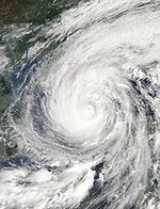
The JTWC designated it a typhoon at 3 p.m. UTC August 6. The JMA upgraded Saomai to a Severe Tropical Storm at 6 p.m. UTC, and as it continued to strengthen, it was upgraded to a typhoon just 12 hours later. Saomai passed into the Area of Responsibility of PAGASA on August 8 and was named Typhoon Juan by PAGASA. On August 8, the storm underwent explosive development, and by August 9 it had become a Category 5-equivalent super typhoon.
Saomai made landfall in Zhejiang
, China on August 10 with maximum sustained winds of 115 knots (1-minute mean), stronger than Chanchu earlier this season. Saomai was responsible for at least 458 deaths, mostly in China, and $2.5 billion (2006 USD) in damage.
and bring rains to the Philippines
. Around 1800 UTC, the JTWC declared that the system had developed into a tropical depression and gave it the number 10W. JMA upgraded it to Tropical Storm Bopha on August 6. The name Bopha was submitted by Cambodia
and is a flower and girls' name. Around this time, the JTWC also upgraded the system to a tropical storm.
The JTWC recognised its existence as a tropical depression at 9 a.m. UTC the same day before upgrading it to a tropical storm at 3 p.m. UTC. The JMA then upgraded it to a severe tropical storm as it slowly churned westwards at 12 a.m. UTC August 7 before downgrading it 18 hours later. Bopha unexpectedly restrengthened into a severe tropical storm at 3 a.m. UTC August 8, before weakening back to a tropical storm at 12 p.m. UTC.
Bopha later made landfall on Taiwan
at about 2 a.m. local time on August 9. At this time, the JTWC reported that Bopha attained winds of 100 km/h (65 mph). Tropical Storm Bopha then weakened into a tropical depression before degenerating into a remnant low on August 10.
The outer bands
of Tropical Storm Bopha produced heavy rains over northern Luzon
, triggering flooding that destroyed 1,200 homes and killed seven people. Two of the fatalities occurred after a home was destroyed by a landslide in Kalinga Province
. The landslide damaged 20 other homes, a church and a school.
As Severe Tropical Storm Bopha approached the island on August 8, the meteorological agency in Taiwan issued land and sea warnings for most of the region. Residents were warned about the possibility of torrential rains, flooding and mudslides. Although the storm was forecast to directly impact the island, all businesses remained open and schools were not closed. In Hong Kong
, the Hong Kong Observatory
issued Standby Signal number one as Bopha came within 800 km (497.1 mi) of the city on August 9. This signal was later discontinued on August 11.
Between August 9 and 10, the remnants of Bopha produced moderate rainfall around Hong Kong, peaking at 45.6 mm (1.8 in). Wind gusts up to 110 km/h (70 mph) were also produced by the storm throughout the city. A storm surge
of 0.48 m (1.6 ft) was recorded in Tai Po Kau on August 8.
on August 12. Early on August 13, as it moved to the north-northwest, the JTWC upgraded it to a tropical storm. The JMA named it Wukong later that day. Wukong
was submitted by People's Republic of China, and it is the name of a character in a Chinese epic. Wukong absorbed Tropical Storm Sonamu shortly before landfall in Japan. Wukong then stalled over Kyūshū
, before starting to jog to the north-northwest. It was downgraded to a tropical depression on August 20.
In post-operational analysis by the JMA, Wukong was upgraded to a severe tropical storm.
, and was named Katring by PAGASA and Sonamu by JMA. The name Sonamu was submitted by DPR Korea
and signifies a pine tree
. Sonamu began interacting with nearby Tropical Storm Wukong on August 15, with the outflow from the stronger Wukong producing unfavourable shear over the cyclone. The JMA declared the system a tropical depression and stopped issuing advisories on August 16. The JTWC followed shortly after.
and entered the Japan Meteorological Agency
's Area of Responsibility at around 6 a.m. UTC, keeping its name while being reclassified as Typhoon Ioke. Ioke had earlier affected Johnston Atoll
. On August 31 the center of the typhoon passed very close to Wake Island
; 200 people were evacuated from there in advance of its approach. Typhoon Ioke then passed just to the northeast of Minami Torishima
, which had been evacuated ahead of the storm, but as a weakened Category 3-equivalent typhoon. Ioke then turned to the northeast, weakening as it started undergoing extratropical transition. The JMA released its final advisory on September 7. The extratropical
remnants of Ioke moved into the Bering Sea
where it caused severe beach erosion
along the western Alaskan coastline.
. Shanshan quickly strengthened and was upgraded into a severe tropical storm on September 11 and a typhoon later that day. Shanshan weakened slightly on September 14, but quickly restrengthened and reached Category 4 status on the JTWC's scale. Shanshan passed through the Yaeyama Islands
in the early morning hours of September 16. The JTWC reported that Shanshan was becoming extratropical
early on September 17, as the typhoon weakened to a tropical storm. The JTWC issued its final advisory on Shanshan later that day, and the JMA issued its last advisory on September 19, after Shanshan completed extratropical transition.
As Shanshan neared Taiwan
, the Central Weather Bureau
and local officials warned of flooding and high winds. However, as Shanshan turned towards Japan, all warnings were cancelled. South Korean forecasters also issued warnings ahead of an expected landfall, but this did not materialise. Ships were diverted as ports were closed as a precaution, while some other boats were forced to remain docked. In Japan, more than 90,000 people were evacuated from Yamaguchi Prefecture
.
Over 200 people were injured by Shanshan and 11 people were killed, mostly in Kyūshū
, although two deaths were reported in South Korea. A tornado spawned by the typhoon caused a train derailment in Nobeoka, Miyazaki
, Japan which caused no fatalities. Peak gusts on Iriomote
reached 155 mph (248 km/h). Flights and trains were delayed, while electricity was cut to about 3000 homes in Korea. A ship also sank off Ulleungdo
.
identified an area of disturbed weather northeast of Chuuk
on September 13. The disturbance drifted to the north over the next few days, gradually increasing in organization. The JTWC issued a Tropical Cyclone Formation Alert
on the disturbance on September 16, and both the JTWC and JMA declared the system a tropical depression early on September 17. The JMA upgraded it to Tropical Storm Yagi later that morning as it moved erratically through the open Pacific Ocean, and the JTWC soon followed suit. The name Yagi was submitted by Japan and means Capricornus
(goat). Yagi was upgraded to a severe tropical storm by the JMA on September 18, and the JTWC designated it a typhoon later that day. The JMA officially upgraded Yagi to typhoon status early on September 19. Yagi was upgraded briefly to a super typhoon by the JTWC from September 21 to September 22. On September 23, the JTWC reported that Yagi was becoming extratropical
as it continued to weaken, and issued its final warning the next day. The JMA downgraded Yagi to a severe tropical storm on September 24. It was the third tropical cyclone in the NW Pacific Basin that attained Category 5 status in 2006. It started to recurve near Chichi-jima
, and never affected major land areas. It became extratropical
near the western Aleutians on September 25.
(PAGASA) named an active low pressure area within its area of responsibility Tropical Depression Milenyo. After issuing a Tropical Cyclone Formation Alert
earlier, the Joint Typhoon Warning Center
issued its first warning on Tropical Depression 18W. On September 26 the Japan Meteorological Agency
named this system Xangsane. The name Xangsane was submitted by Laos
and means elephant
. Later that day, the JMA upgraded Xangsane to a severe tropical storm. A bout of rapid intensification followed, and all three agencies, the JMA, JTWC and PAGASA all upgraded the storm to a typhoon late on September 26 or early September 27. Xangsane made landfall on Samar Island
as a severe tropical storm.
The typhoon dropped heavy rainfall in the Philippines
. To avoid the storm, transit authorities kept seacraft at several ports in the archipelago, leaving over 3,500 passengers stranded. Xangsane also prompted Philippine officials to close all schools, financial markets, and government offices in and around Manila
. The typhoon killed over 200 people in the country, and produced strong winds and rainfall, downing power lines and causing mudflow
s. The strong winds caused moderate crop damage totaling to $7.2 million (2006 USD).
Xangsane made landfall as a typhoon near Hue
early on October 1. The JTWC stopped issuing advisories soon after, and the JMA downgraded it to a severe tropical storm. Xangsane killed 71 in Vietnam
.
developed into Tropical Depression 19W. The JMA had already been monitoring the storm. It was named Neneng by PAGASA, and later that evening was upgraded to a tropical storm by the Philippine authorities. The JMA and JTWC both designated the storm a tropical storm the next day, and it was named Bebinca by the JMA. Bebinca is a type of Macanese
milk pudding
.
The JTWC downgraded it to a tropical depression briefly between October 4 and October 5 as wind shear took its toll. Its low-level circulation then became exposed with dry air entering the system, and both the JMA and JTWC declared the storm as a dissipating tropical depression on October 6. It soon became entrained within the circulation of a storm-force extratropical low
, which swept across the Honshū
coastal waters and led to 33 people dead or missing. It was upgraded to a severe tropical storm in post analysis.
in high sea-surface temperatures gained enough convection and was designated Tropical Storm Rumbia by the JMA, although the JTWC had not even carried it as a tropical depression. Rumbia is a type of palm tree that yields sago
. Later that day, the JTWC issued a Tropical Cyclone Formation Alert
, and began warnings on Tropical Depression 20W the next day. Rumbia slowly began to intensify while moving to the northwest, but on October 6 its low-level circulation became fully exposed, and the JTWC issued a final warning. The JMA followed suit soon after. The remnants of Rumbia were later no longer distinct from the extratropical low associated with Bebinca.
, and is a traditional title for Pohnpei
chiefs. Soulik continued to intensify through October 10, and the JMA upgraded it to a severe tropical storm. Agrihan
was put under a tropical storm watch, which was later upgraded to a warning. In 18 hours on October 11, 8 inches (205 mm) of rain was reported on Pagan Island
. After days of gradual strengthening, it became a typhoon on October 12, stalling over Iwo Jima
. Soulik reached Category 2 status on the Saffir-Simpson Hurricane Scale
on October 13 before gradually weakening and moving northeastward rapidly as it became extratropical
.
on October 24. The disturbance moved west-northwestward over the next two days and gradually became better organized, and the Joint Typhoon Warning Center
issued a Tropical Cyclone Formation Alert
on the system on October 26. The system was designated Tropical Depression 22W by the JTWC later that day. The system continued to strengthen, and the JTWC upgraded it to a tropical storm on October 27. The Japan Meteorological Agency
later followed suit and designated the system Tropical Storm Cimaron. The name Cimaron was submitted by the Philippines
, and is a type of wild ox
. The system quickly intensified, and was upgraded to a severe tropical storm by the JMA later that day. The system continued its quick intensification and was upgraded to a typhoon by both the JTWC and JMA on October 28. Further intensification occurred overnight, and the typhoon had rapidly deepened
65 hPa
in 24 hours, from 985 hPa to 920 hPa, causing the JTWC to upgrade it to a 140-kt super typhoon at 9 a.m. UTC on October 29. It made landfall at about 12:30 p.m. UTC the same day on Northern Luzon
. There, especially in Isabela Province
, it lashed winds as much as 195 km/h and gusts as much as 230 km/h. Actually, all or parts of four provinces (Isabela, Quirino, Cagayan
and Aurora
) are declared under Signal #4 as the typhoon struck the island.
Cimaron then re-intensified after crossing the island, but not to its original strength, and was expected to curve towards Hainan, instead of moving towards Vietnam
as previously forecast. On November 1, the JTWC upgraded the typhoon back into a Category 3-equivalent storm, and forecast that it would make a direct impact on Hong Kong. However, prediction models showed conflicting forecasts, and Cimaron remained quasi-stationary and weakened to a severe tropical storm on November 2. Dry air entrainment caused further weakening, with the JTWC dropping it to a minimal tropical storm at 3 p.m. UTC the next day. It weakened further, upwelling itself. The JTWC issued its final warning at 3 p.m. UTC on November 4. The JMA continued advisories on Cimaron until 12 a.m. UTC on November 6, when it was downgraded to a weak tropical depression.
The typhoon killed at least 19 people, many of whom drowned, and left 15 missing in the northern Philippines. It also killed a woman and her child after both are hit by a sheet of galvanized iron in Dilasag, Aurora Province, serving as the first human casualties. Further casualties happened as the typhoon passed through Luzon. Despite these, however, classes in Metro Manila
were still not suspended. It also caused at least US$9 million in damage. 90% of the houses were damaged in a coastal town near where Cimaron made landfall. In the aftermath of the storm's passage across the Philippines, the Swedish International Development Cooperation Agency
contributed 2.5 million Swedish krona
(US$350,000) to aid efforts.
on October 31, and moved west-northwestward over the next week without any increase in organization due to an unfavorable environment, until November 6, when it encountered more favorable conditions, and the Japan Meteorological Agency
declared it a tropical depression on November 8. The Joint Typhoon Warning Center
issued a Tropical Cyclone Formation Alert
on the system later that day, and PAGASA
named the system Tropical Depression Queenie shortly after. The JTWC classified it as Tropical Depression 23W early on November 9. According to the JTWC, lack of equatorial outflow prevented rapid intensification of the system. Later that day at 12 p.m. UTC, the JMA upgraded it to a tropical storm named it Chebi. The name Jebi, the correct spelling means swallow
in Korean. The JTWC and PAGASA both followed suit later that day. Early on November 10, the JMA upgraded Chebi to a severe tropical storm as it continued to move west towards the Philippines
, following a similar track as Typhoon Cimaron earlier in the season.
Just hours later, the JMA upgraded Chebi from severe tropical storm with 10-minute sustained winds of 55 knots to a typhoon with winds of 95 knots, with a pressure decrease of 40 hPa
over three hours. The JTWC followed suit, upping Chebi from a tropical storm with 1-minute sustained winds of 55 knots to a Category 4-equivalent
typhoon at 9 a.m. UTC. PAGASA raised Public Storm Warning Signal #4 for three provinces in Luzon
, making Chebi the second storm (Typhoon Cimaron served as the first one that year.) in as many weeks to force a Signal #4. After rapidly deepening
, Chebi weakened as it approached the Philippines. It made its first landfall near Casiguran, Aurora
early on November 11, crossed the Lingayen Gulf
and its second landfall on Barangay
Lucap, Alaminos City
about 8 hours later.
Encountering dry air entrainment and increased vertical wind shear
in the South China Sea
, Chebi began to gradually weaken to a severe tropical storm on November 12. It continued to weaken, turning northwards towards Hainan
, and was downgraded to a tropical storm the next day. On November 14, the JMA issued its last advisory on the dissipating tropical depression. The JTWC issued its final warning later that same day as Chebi dissipated under the strong shear.
All told, the typhoon caused further casualties as well as damage caused by the earlier Typhoon Cimaron. After passing through Luzon, it left 1 dead and 10 injured. In Aurora Province
, it caused floods, cutting the province's road system, as well as zero visibility, further isolating it from relief efforts.
on November 24. Wind shear
near the disturbance soon decreased, allowing the depression to organize a little. It was designated a tropical depression by Japan Meteorological Agency
on November 25, and later that day the Joint Typhoon Warning Center
started issuing warnings on the system as it moved west-northwest towards Yap
. The depression strengthened because it was in an area of high sea-surface temperatures, and there were distinct cloud features of anticyclonic
outflow, according to the JMA. It was upgraded to a tropical storm on the afternoon of November 26 and named Durian. The name Durian refers to a fruit, "Durio zibethinus
", and was submitted to the naming list by Thailand
.
Moving west to west-northwestward, Durian intensified slowly. It became a severe tropical storm on November 27, and the next day it was named Reming by PAGASA
when it entered the Philippine Area of Responsibility. Later on November 28, both the JMA and JTWC upgraded it to a typhoon as it continued to track towards the Philippines
. A quick bout of intensification occurred on November 29, causing the JMA to upgrade the storm to 100 knots in wind intensity, and the JTWC to give it a Dvorak classification
of 6.5 (127 kt) in a satellite
fix. In 6 hours, Durian intensified from 90 kt 1-minute sustained winds to 125 kt winds. The JTWC then forecast a direct hit over Metro Manila
later that day when it upgraded the storm to a super typhoon. PAGASA raised Public Storm Warning Signal 4, its highest warning level, over Catanduanes
, Albay
, Camarines Norte
and Camarines Sur
. It was the third time in 2006, and the third time in a row, that PAGASA raised Signal #4. Durian began to weaken slightly as it approached land, undergoing an eyewall replacement cycle
, but quickly regained peak strength.
PAGASA claimed that the storm made landfall on the morning of November 30 over southern Catanduanes
, although the JMA and JTWC did not recognize this landfall. Durian then made another landfall after crossing the Lagonoy Gulf
in northeastern Albay
. After weakening due to interaction with land, Durian was downgraded back to a typhoon by the JTWC. The storm continued to move west, making landfalls on the Bondoc Peninsula
in Quezon
, on Marinduque
and finally on Oriental Mindoro
before exiting to the South China Sea
.
Encountering dry air entrainment and vertical wind shear
, Durian weakened slightly at first, but slowly began to reorganise and restrengthen as it neared Vietnam
. Durian began to turn slightly southwest towards Nha Trang
and Ho Chi Minh City
on December 3. Eventually, Durian began to weaken again, and by December 4, the JMA downgraded it to a severe tropical storm. The storm maintained intensity as it skirted the Vietnamese coast moving southwest. After a brief second stint at typhoon strength, Durian finally made landfall in Ben Tre Province
on December 5. The system rapidly weakened over land, and the JMA downgraded it to a tropical storm. The JMA and JTWC issued their final advisories later that day as Durian emerged into the Gulf of Thailand
as a weak tropical depression. The remnants of Durian then crossed the coast of southern Thailand
as it moved into the Bay of Bengal
.
The storm killed at least 720 in the Philippines
. The most damage occurred in Albay Province where the storm created mudslides of volcanic ash and boulders off Mayon Volcano
. The Padang barangay
of Legazpi City
was severely affected with a large portion of the town covered in mud up to houses' roofs. At least 81 people have died and 16 people are missing in Vietnam
from the storm.
southeast of Chuuk
. Although convection decreased in the next few hours, on December 5 the JTWC once again noted flaring deep convection, and late on December 6 a Tropical Cyclone Formation Alert
was issued. On the morning of December 7, both the JTWC and Japan Meteorological Agency
-RSMC Tokyo reported that a tropical depression had formed. Soon after, the depression entered the area of responsibility of PAGASA
, who named it Seniang. The depression strengthened throughout the day, and the JMA upgraded it to Tropical Storm Utor later that day. The name Utor was submitted by the United States on behalf of the Marshall Islands
, and is a Marshallese
word for squall line
.Signal no.3 has been raised in the provinces of Cebu
,Leyte,Samar Provinces
On December 8, the JMA upgraded Utor to a severe tropical storm. It intensified further and was upgraded to a typhoon by the JMA on the morning of December 9, with PAGASA
and JTWC doing the same. The storm made landfall shortly after noon local time the same day. After crossing the Philippines
, Utor took a track similar to Typhoon Chebi in November, first moving northwest then threatening to take aim at Hong Kong. It restrengthened to an 85-kt typhoon, before it slowed as it tracked in a weak steering environment within a weakness in the subtropical ridge
. It then weakened as wind shear increased and dry air entrainment occurred. The JMA downgraded it to a severe tropical storm on December 13, and to a tropical storm the same day. The next day the JTWC downgraded the storm to a tropical storm and issued its last advisory.
The 2006 ASEAN
and East Asia Summit
, originally scheduled to start December 10, was put back a month due to the storm. Typhoon Utor killed at least 78 people and left 49 others missing in the Philippines. Damages from the typhoon were estimated at $1.9 million (2006 USD).
Typhoon Utor was blamed for heavy rains of up to 350 mm within 24 hours in southern Peninsular Malaysia
, specifically Johor
, Negeri Sembilan
, Melaka and Pahang
, causing massive floods within the southern region on December 18, 2006, which was considered as the worst in the Malaysian southern region history. However, there were also reports a few days earlier that adverse weather was not to be blamed on the typhoon. The worst-affected areas were Segamat
and Kota Tinggi
, where both towns were totally inaccessible by land after all main roads leading to those towns were all flooded. Until December 24, 2006, the floods had claimed 8 lives.
started issuing public bulletins on a tropical depression southwest of Guam
. The Joint Typhoon Warning Center
initiated warnings on Tropical Depression 26W the next day, despite having not issued a Tropical Cyclone Formation Alert
. The system was upgraded to a tropical storm by the JMA and named Trami, which is a kind of rose
tree. This name was submitted by Vietnam
. The storm moved west-northwest rapidly towards the Philippines
, but struggled against wind shear and an approaching cold front. Entering the PAGASA Area of Responsibility on December 18 as it maintained minimal tropical storm intensity, it was named Tomas. The JTWC issued its final warning later that day, having never upgraded the storm to tropical storm strength, citing no indication of a significant low-level circulation centre. On December 19, the JMA downgraded the storm to a tropical depression and issued its last public bulletin as the storm dissipated over water.
in the southern Philippines. As it traveled in an erratic northwestward direction, it slowly became better organized. On January 23, the JMA assessed the storm to have attained winds of 55 km/h (35 mph 10-minute winds). Around the same time, PAGASA began issuing advisories on the system and gave it the local name Agaton. The depression weakened as it crossed over northern Samar Island
and southern Luzon
. Traveling towards the west, the system failed to strengthen and dissipated on January 27 while located over the South China Sea
, about halfway between Vietnam
and Borneo
.
southeast of Palau
. The JTWC
upgraded it to Tropical Storm 01W at 3 p.m. UTC the same day. The JTWC downgraded it back to a depression on March 5 due to shear, and it never regained tropical storm strength before dissipating on March 7.
In the six years since current naming conventions were introduced, this was the 12th time the JTWC recognised a tropical storm not named by the JMA, after three storms in the 2001 Pacific typhoon season
, two storms each in 2000
, 2002
, and 2004
and one each in 2003
and 2005
.
, Hainan
. The depression moved northwest and made landfall at 7:10 p.m. CST in Hainan on the same day. The storm's lowest pressure was around 998 hPa. On the next morning, it entered Gulf of Tonkin and strengthened slightly. Eventually, the depression made its second landfall near Guangxi/Vietnam border around noon and rapidly weakened over land.
declared the formation of a tropical depression near Hainan
. Hong Kong Observatory
followed later that afternoon. The depression necessitated Tropical Cyclone Signal No.1 in Hong Kong and Macau
, which means that the centre of a tropical cyclone is within 800 km (497.1 mi) of the respective Special Administrative Regions, and may later affect them. The depression made landfall at Guangdong at 5:55 a.m. CST on August 25 and dissipated later that morning.
The JTWC designated the system as a Tropical Depression at 9 p.m. UTC August 24, but only issued two warnings on the system.
identified a tropical depression about 360 kilometres east-northeast of Xisha on September 12 and issued Standby Signal No.1
accordingly. The tropical depression also necessitated the issuance of the Standby Signal No. 1 in Macau at 2 p.m. UTC on the same day. The JTWC designated it as a tropical depression, 15W, at 9 p.m. UTC September 12. The JMA had earlier already identified it as a tropical depression. As it strengthened and edged closer to the coastal areas of Guangdong
, the Strong Wind Signal No. 3 was issued both in Hong Kong and Macau on September 13. It made landfall in western Guangdong
around 11:30 p.m. CST that night and dissipated inland.
on September 22. The system was organized enough to be classified as Tropical Depression 17W by the JTWC the next day. The JTWC briefly upgraded it to a tropical storm on September 24. It weakened under heavy vertical wind shear and the JTWC issued its final advisory on Tropical Depression 17W before landfall in Vietnam
. The storm passed just south of Hainan and brought heavy rain to the area. The maximum rainfall recorded was 143 mm. CMA kept it as a tropical storm until it made landfall in Vietnam in the morning of September 25. In the six years since current naming conventions were introduced, this was the 13th time the JTWC recognised a tropical storm not named by the JMA. This was also the 3rd time that CMA recognised a tropical storm not named by the JMA, after one storm in the 2000 Pacific typhoon season, zero in 2001, 2002 and 2003, one in 2004.
In the post-season analysis supplied by the JTWC, it was determined that 17W never reached tropical storm intensity, thus it was downgraded to a tropical depression.
was designated Tropical Depression Ompong by PAGASA. The depression slowly moved westward toward the Philippines
, but wind shear from Typhoon Soulik prevented any intensification. The depression degenerated into an area of low pressure early the next day.
. Names are selected from the following sequential list, there is no annual list. Names were contributed by 13 members of the ESCAP/WMO Typhoon Committee, except for Singapore
. The 13 nations or territories, along with the Federated States of Micronesia
, each submitted 10 names, which are used in alphabetical order by the English name of the country. The names on the list are identical to that used in the 2005 season with the exception of Pongsona, Maemi, Sudal, Rananim, Yanyan and Tingting which were replaced by Noul, Mujigae, Mirinae, Fanapi, Dolphin and Lionrock respectively. The first storm of the season was named Chanchu, and the last storm was named Trami.
One storm, Hurricane Ioke
, entered the Western North Pacific from the Central North Pacific, retaining its name assigned by the Central Pacific Hurricane Center
. It was given the international typhoon number 0612 by the JMA.
(PAGASA) uses its own naming scheme for tropical cyclones within its area of responsibility. Lists are recycled every four years. On the 2006 list, the name "Gloria" was replaced by "Glenda". .
in December 2006, it was decided that five names - Chanchu
, Bilis, Saomai
, Xangsane
and Durian
would be retired, with replacement names due to be submitted at the 40th annual meeting of the committee. The names Sanba, Maliksi, Son Tinh, Leepi and Mangkhut were chosen respectively. The Philippine Atmospheric, Geophysical and Astronomical Services Administration (PAGASA) announced that the names Milenyo and Reming would be retired due to extensive damage and loss of life. The names Mario and Ruby were chosen to replaced Milenyo and Reming respectively.
Tropical cyclone
A tropical cyclone is a storm system characterized by a large low-pressure center and numerous thunderstorms that produce strong winds and heavy rain. Tropical cyclones strengthen when water evaporated from the ocean is released as the saturated air rises, resulting in condensation of water vapor...
s tend to form in the northwestern Pacific Ocean between May and November. These dates conventionally delimit the period of each year when most tropical cyclones form in the northwestern Pacific Ocean.
The scope of this article is limited to the Pacific Ocean, north of the equator and west of the international date line
International Date Line
The International Date Line is a generally north-south imaginary line on the surface of the Earth, passing through the middle of the Pacific Ocean, that designates the place where each calendar day begins...
. Storms that form east of the date line and north of the equator are called hurricanes; see 2006 Pacific hurricane season
2006 Pacific hurricane season
The 2006 Pacific hurricane season was the most active Pacific hurricane season since 2000 producing 19 tropical storms or hurricanes. Eighteen developed within the National Hurricane Center area of warning responsibility, which is east of 140ºW, and one storm formed between 140ºW and the...
. Tropical Storms formed in the entire West Pacific basin are assigned a name by the Japan Meteorological Agency
Japan Meteorological Agency
The or JMA, is the Japanese government's weather service. Charged with gathering and reporting weather data and forecasts in Japan, it is a semi-autonomous part of the Ministry of Land, Infrastructure and Transport...
. Tropical depressions in this basin have the "W" suffix added to their number. In addition, the Philippine Atmospheric, Geophysical and Astronomical Services Administration
Philippine Atmospheric, Geophysical and Astronomical Services Administration
The Philippine Atmospheric, Geophysical and Astronomical Services Administration is a Philippine national institution dedicated to provide flood and typhoon warnings, public weather forecasts and advisories, meteorological, astronomical, climatological, and other specialized information and...
(PAGASA) assigns names to tropical cyclones (including tropical depressions) that enter or form in the Philippine area of responsibility. These names, however, are not in common use outside of the Philippines.
Storms
In storm information below, windspeed advisories differ from the Joint Typhoon Warning Center to the Japan Meteorological Agency as the JTWC uses the U.S. criteria of 1-minute mean to designate maximum sustained winds, while the JMA uses the 10-minute mean wind criteria to designate tropical cyclone maximum sustained winds. This difference generally means that JTWC maximum winds will appear to be higher than the maximum winds described by the JMA for the same cyclone.Typhoon Chanchu (Caloy)
An area of disturbed weather formed around May 5 and moved westWest
West is a noun, adjective, or adverb indicating direction or geography.West is one of the four cardinal directions or compass points. It is the opposite of east and is perpendicular to north and south.By convention, the left side of a map is west....
ward. The Joint Typhoon Warning Center
Joint Typhoon Warning Center
The Joint Typhoon Warning Center is a joint United States Navy – United States Air Force task force located at the Naval Maritime Forecast Center in Pearl Harbor, Hawaii...
released a Tropical Cyclone Formation Alert
Tropical Cyclone Formation Alert
A Tropical Cyclone Formation Alert is a bulletin released by the U.S. Navy-operated Joint Typhoon Warning Center in Honolulu, Hawaii or the Naval Maritime Forecast Center in Norfolk, Virginia, warning of the possibility of a tropical cyclone forming from a tropical disturbance that has been...
on May 8, shortly before it upgraded the storm to a Tropical Depression. It became a tropical storm on May 9. The name "Chanchu" was submitted by Macau
Macau
Macau , also spelled Macao , is, along with Hong Kong, one of the two special administrative regions of the People's Republic of China...
and means pearl
Pearl
A pearl is a hard object produced within the soft tissue of a living shelled mollusk. Just like the shell of a mollusk, a pearl is made up of calcium carbonate in minute crystalline form, which has been deposited in concentric layers. The ideal pearl is perfectly round and smooth, but many other...
. The JTWC then upgraded it to a typhoon on May 10. The storm maintained a westerly track and made two landfalls in the Philippines
Philippines
The Philippines , officially known as the Republic of the Philippines , is a country in Southeast Asia in the western Pacific Ocean. To its north across the Luzon Strait lies Taiwan. West across the South China Sea sits Vietnam...
, causing 32 deaths in the country and $1.9 million in damage, much of it to agriculture.
After Chanchu left the Philippines, the JMA upgraded it to a typhoon. Chanchu turned to the north in the South China Sea
South China Sea
The South China Sea is a marginal sea that is part of the Pacific Ocean, encompassing an area from the Singapore and Malacca Straits to the Strait of Taiwan of around...
and affected hundreds of Vietnam
Vietnam
Vietnam – sometimes spelled Viet Nam , officially the Socialist Republic of Vietnam – is the easternmost country on the Indochina Peninsula in Southeast Asia. It is bordered by China to the north, Laos to the northwest, Cambodia to the southwest, and the South China Sea –...
ese fishermen. Then, it became a super typhoon, only the second ever recorded in the South China Sea, but was one for only less than a day. The only other super typhoon to form in the South China Sea in recorded history is Ryan
Ryan
-Places:Australia* Division of Ryan, an electoral district in the Australian House of Representatives, in Queensland*Ryan, New South WalesUnited States*Ryan, California*Ryan, former name of Lila C, California*Ryan, Iowa*Ryan, Minnesota*Ryan, Oklahoma...
in 1995. Chanchu is also the most intense typhoon on Hong Kong Observatory
Hong Kong Observatory
Hong Kong Observatory is a department of the Hong Kong government. The Observatory forecasts weather and issues warnings on weather-related hazards...
's record to enter the South China Sea in May. Chanchu necessitated the Strong Wind Signal no. 3
Hong Kong Tropical Cyclone Warning Signals
The Hong Kong tropical cyclone warning signals or informally typhoon signals are a set of signals used to indicate the threat or effects of a tropical cyclone. The Hong Kong Observatory issues the warning signal if a tropical cyclone is centred within of Hong Kong and may affect Hong Kong later...
in both Hong Kong and Macau. It turned northeastward and made a final landfall along the southeastern seaboard of China on May 18 resulting in at least 25 deaths and a direct economic loss of 7 billion yuan
Chinese yuan
The yuan is the base unit of a number of modern Chinese currencies. The yuan is the primary unit of account of the Renminbi.A yuán is also known colloquially as a kuài . One yuán is divided into 10 jiǎo or colloquially máo...
. Chanchu became extratropical later that day.
Tropical Storm Jelawat (Domeng)
An area of disturbed weather that began as a part of a monsoon trough formed around June 23 east of the Philippines, and moved slowly over the islands. The Joint Typhoon Warning CenterJoint Typhoon Warning Center
The Joint Typhoon Warning Center is a joint United States Navy – United States Air Force task force located at the Naval Maritime Forecast Center in Pearl Harbor, Hawaii...
released a Tropical Cyclone Formation Alert
Tropical Cyclone Formation Alert
A Tropical Cyclone Formation Alert is a bulletin released by the U.S. Navy-operated Joint Typhoon Warning Center in Honolulu, Hawaii or the Naval Maritime Forecast Center in Norfolk, Virginia, warning of the possibility of a tropical cyclone forming from a tropical disturbance that has been...
on June 25 as the system moved over the Philippines, and upgraded the system to Tropical Depression 03W the next day. The depression continued to organize as it moved away from the Philippines, and the JTWC upgraded it to Tropical Storm 03W on June 27. The Japan Meteorological Agency designated the storm as Tropical Storm Jelawat shortly after. The name Jelawat was submitted by Malaysia, and is a name for a type of carp
Carp
Carp are various species of oily freshwater fish of the family Cyprinidae, a very large group of fish native to Europe and Asia. The cypriniformes are traditionally grouped with the Characiformes, Siluriformes and Gymnotiformes to create the superorder Ostariophysi, since these groups have certain...
.
Jelawat moved generally northwestward over the South China Sea
South China Sea
The South China Sea is a marginal sea that is part of the Pacific Ocean, encompassing an area from the Singapore and Malacca Straits to the Strait of Taiwan of around...
during the next day, and weakened back to a tropical depression on June 28. The depression made landfall in southern China at 7:40 a.m. CST on June 29 and dissipated later that day.
The storm dropped heavy rainfall across southern China and Haikou
Haikou
Hǎikǒu , is the capital and most populous city of Hainan Province, in the People's Republic of China. It is situated on the northern coast of Hainan, by the mouth of the Nandu River...
recorded a rainfall of 309.7 mm (12 inches) during the storm passage. A total of 8.6 inches (220 mm) rain fell in 16 hours in Kampung Bundu, Malaysia. The rainfall killed seven people and left one missing. The flooding from Jelawat ruined 200 square kilometres of farmland and destroyed 190 houses.
Typhoon Ewiniar (Ester)
On June 29, a persistent tropical disturbance was classified as a tropical depression by the JTWC while east of PalauPalau
Palau , officially the Republic of Palau , is an island nation in the Pacific Ocean, east of the Philippines and south of Tokyo. In 1978, after three decades as being part of the United Nations trusteeship, Palau chose independence instead of becoming part of the Federated States of Micronesia, a...
. The depression moved northwestward and was upgraded to Tropical Storm 04W by the JTWC on June 30. The JMA designated the storm Tropical Storm Ewiniar at around the same time. The name "Ewiniar" was submitted by the Federated States of Micronesia
Federated States of Micronesia
The Federated States of Micronesia or FSM is an independent, sovereign island nation, made up of four states from west to east: Yap, Chuuk, Pohnpei and Kosrae. It comprises approximately 607 islands with c...
, and refers to a traditional storm god of Chuuk
Chuuk
Chuuk — formerly Truk, Ruk, Hogoleu, Torres, Ugulat, and Lugulus — is an island group in the south western part of the Pacific Ocean. It comprises one of the four states of the Federated States of Micronesia , along with Kosrae, Pohnpei, and Yap. Chuuk is the most populous of the FSM's...
.
Ewiniar was responsible for at least 30 deaths in China, which it brushed as a typhoon. The typhoon gradually weakened as it moved over colder waters, and made landfall in South Korea on July 10 as a severe tropical storm. As Ewiniar moved across the country, it passed within 30 miles (48.3 km) of Seoul
Seoul
Seoul , officially the Seoul Special City, is the capital and largest metropolis of South Korea. A megacity with a population of over 10 million, it is the largest city proper in the OECD developed world...
. No tropical cyclone had come that close to Seoul in recent years. The storm brought heavy rain that triggered floods and mudslides in the southern part of the country, killing at least six people. Ewiniar became extratropical over the Sea of Japan
Sea of Japan
The Sea of Japan is a marginal sea of the western Pacific Ocean, between the Asian mainland, the Japanese archipelago and Sakhalin. It is bordered by Japan, North Korea, Russia and South Korea. Like the Mediterranean Sea, it has almost no tides due to its nearly complete enclosure from the Pacific...
on the same day.
Severe Tropical Storm Bilis (Florita)
A tropical disturbance northeast of YapYap
Yap, also known as Wa'ab by locals, is an island in the Caroline Islands of the western Pacific Ocean. It is a state of the Federated States of Micronesia. Yap's indigenous cultures and traditions are still strong compared to other neighboring islands. The island of Yap actually consists of four...
developed sufficient convection to be designated a tropical depression on July 8. The depression strengthened into a tropical storm the next day, and was designated Tropical Storm Bilis by the JMA. The word "Bilis", submitted by the Philippines
Philippines
The Philippines , officially known as the Republic of the Philippines , is a country in Southeast Asia in the western Pacific Ocean. To its north across the Luzon Strait lies Taiwan. West across the South China Sea sits Vietnam...
, means speed or swiftness. PAGASA operationally treated this storm as a typhoon for a short time on July 13, but it officially remained a tropical storm as it moved west-northwestward toward Taiwan
Taiwan
Taiwan , also known, especially in the past, as Formosa , is the largest island of the same-named island group of East Asia in the western Pacific Ocean and located off the southeastern coast of mainland China. The island forms over 99% of the current territory of the Republic of China following...
. After moving over northern Taiwan, Bilis made landfall in Fujian
Fujian
' , formerly romanised as Fukien or Huguing or Foukien, is a province on the southeast coast of mainland China. Fujian is bordered by Zhejiang to the north, Jiangxi to the west, and Guangdong to the south. Taiwan lies to the east, across the Taiwan Strait...
, China at 12:50 p.m. CST on July 14, weakening into a tropical depression inland the next day. JMA carried the system as a tropical depression until July 17. Bilis brought very heavy rain, widespread flooding, landslides, and strong winds to the Philippines
Philippines
The Philippines , officially known as the Republic of the Philippines , is a country in Southeast Asia in the western Pacific Ocean. To its north across the Luzon Strait lies Taiwan. West across the South China Sea sits Vietnam...
, Taiwan and areas of mainland China, causing 672 deaths and $4.4 billion (2006 USD
United States dollar
The United States dollar , also referred to as the American dollar, is the official currency of the United States of America. It is divided into 100 smaller units called cents or pennies....
) in damage.
Typhoon Kaemi (Glenda)
A tropical depression formed on July 18 near the Caroline IslandsCaroline Islands
The Caroline Islands are a widely scattered archipelago of tiny islands in the western Pacific Ocean, to the north of New Guinea. Politically they are divided between the Federated States of Micronesia in the eastern part of the group, and Palau at the extreme western end...
, it quickly strengthened to tropical storm strength the same day. On July 19, the storm was named Kaemi by the JMA. The correct name Gaemi was submitted by South Korea and is a Korean word for ant
Ant
Ants are social insects of the family Formicidae and, along with the related wasps and bees, belong to the order Hymenoptera. Ants evolved from wasp-like ancestors in the mid-Cretaceous period between 110 and 130 million years ago and diversified after the rise of flowering plants. More than...
. It strengthened into a severe tropical storm on July 20, and further deepened into a typhoon 24 hours later. Kaemi made landfall in Jinjiang
Jinjiang
Jinjiang City is a county-level city of Quanzhou Municipality in Fujian. It is located in the southeastern part of the province, on the right or south bank of the Jin River, across from Quanzhou's urban district of Fengze...
, Fujian
Fujian
' , formerly romanised as Fukien or Huguing or Foukien, is a province on the southeast coast of mainland China. Fujian is bordered by Zhejiang to the north, Jiangxi to the west, and Guangdong to the south. Taiwan lies to the east, across the Taiwan Strait...
at 3:50 p.m. CST on July 25 as a minimal typhoon.
Heavy rainfall in Taiwan caused flooding and four minor injuries. Rain also fell heavily in the northern Philippines. The storm has also killed at least 32 people in China, while another 60 people are missing. Agricultural losses in Taiwan amounted to NT$73 million (US$2.2 million). Total damages from the storm amounted to $450 million.
Typhoon Prapiroon (Henry)
PAGASA named a system east of the PhilippinesPhilippines
The Philippines , officially known as the Republic of the Philippines , is a country in Southeast Asia in the western Pacific Ocean. To its north across the Luzon Strait lies Taiwan. West across the South China Sea sits Vietnam...
as Tropical Depression Henry later on the same day that the JMA recognised it as a tropical depression on July 28. The JTWC upgraded this system to a tropical storm on the morning of August 1. Hong Kong Observatory
Hong Kong Observatory
Hong Kong Observatory is a department of the Hong Kong government. The Observatory forecasts weather and issues warnings on weather-related hazards...
also did so and issued the Tropical Cyclone Signal No. 1 that same afternoon, and shortly after the JMA upgraded the system to Tropical Storm Prapiroon. The name Prapiroon was submitted by Thailand
Thailand
Thailand , officially the Kingdom of Thailand , formerly known as Siam , is a country located at the centre of the Indochina peninsula and Southeast Asia. It is bordered to the north by Burma and Laos, to the east by Laos and Cambodia, to the south by the Gulf of Thailand and Malaysia, and to the...
and is the name of a Thai rain deity. The JMA upgraded the storm to a severe tropical storm on the morning of August 2. PAGASA ceased advisories on the storm shortly after as it moved out of its area of responsibility. The JTWC and the HKO upgraded Prapiroon to a typhoon at 3 a.m. UTC, while the JMA officially upgraded it to a typhoon at 12 p.m. UTC (8 p.m. HKT
Hong Kong Time
Hong Kong Time is the time in Hong Kong, observed at UTC+8 all year round. The Hong Kong Observatory is the official timekeeper of the Hong Kong Time.-Time standards:...
). Prapiroon necessitated the first Tropical Cyclone Signal No. 8 in Macau this year. In Hong Kong, the flag raising ceremony at the Golden Bauhinia Square was cancelled due to strong wind. Prapiroon made landfall at 7:20 p.m. CST on August 3.
The strong winds due to the storm resulted in 70% of flights being cancelled, delayed or diverted in the Hong Kong International Airport
Hong Kong International Airport
Hong Kong International Airport is the main airport in Hong Kong. It is colloquially known as Chek Lap Kok Airport , being built on the island of Chek Lap Kok by land reclamation, and also to distinguish it from its predecessor, the closed Kai Tak Airport.The airport opened for commercial...
, the highest since the opening in 1999. However, the airport remained open throughout the storm passage and many flights successfully landed or took off on August 3. Inbound flights were rerouted to nearby airports and outbound flights were cancelled or postponed. On landfall in Guangdong
Guangdong
Guangdong is a province on the South China Sea coast of the People's Republic of China. The province was previously often written with the alternative English name Kwangtung Province...
province, China, it forced the evacuation of some 660,000 people and caused an estimated 5.4 billion Chinese yuan worth of damage. 77 people were reported killed. It also affected Hunan
Hunan
' is a province of South-Central China, located to the south of the middle reaches of the Yangtze River and south of Lake Dongting...
, Guangxi
Guangxi
Guangxi, formerly romanized Kwangsi, is a province of southern China along its border with Vietnam. In 1958, it became the Guangxi Zhuang Autonomous Region of the People's Republic of China, a region with special privileges created specifically for the Zhuang people.Guangxi's location, in...
and Hainan
Hainan
Hainan is the smallest province of the People's Republic of China . Although the province comprises some two hundred islands scattered among three archipelagos off the southern coast, of its land mass is Hainan Island , from which the province takes its name...
. Prapiroon degenerated into an area of low pressure on August 6.
Typhoon Maria
JMA identified a tropical depression southwest of Minami TorishimaMinami Torishima
or Marcus Island is an isolated Japanese coral atoll in the northwestern Pacific Ocean, located some SE of Tokyo and east of the closest Japanese island, South Iwo Jima of the Ogasawara Islands, and nearly on a straight line between Tokyo and Wake Island, which is east southeast...
on August 4 and began issuing advisories. On August 5, the system had sufficiently strengthened to be named Tropical Storm Maria. The name Maria was submitted by the United States and is a common Chamorro feminine name
Given name
A given name, in Western contexts often referred to as a first name, is a personal name that specifies and differentiates between members of a group of individuals, especially in a family, all of whose members usually share the same family name...
.
The JTWC designated this system as a tropical depression later that day before upgrading it to a tropical storm on August 6, while the JMA upgraded it to a severe tropical storm at 6 a.m. UTC. Maria turned to the north, threatening Japan's mainland. JTWC briefly upgraded Maria to a typhoon on August 7, but issued its final advisory two days later as it started to turn extratropical.
In their post season analyses, the JMA upgraded the storm to a 80 mph (130 km/h) typhoon, while the JTWC downgraded it to a 70 mph (110 km/h) tropical storm.
Typhoon Saomai (Juan)
The JTWC identified a tropical depression near the Caroline IslandsCaroline Islands
The Caroline Islands are a widely scattered archipelago of tiny islands in the western Pacific Ocean, to the north of New Guinea. Politically they are divided between the Federated States of Micronesia in the eastern part of the group, and Palau at the extreme western end...
late on August 4 UTC. The JMA designated it as such at 12 a.m. UTC August 5. Nine hours later, the JTWC upgraded Tropical Depression 08W to a tropical storm, three hours before the JMA named it Saomai. The name is from the Vietnamese
Vietnamese language
Vietnamese is the national and official language of Vietnam. It is the mother tongue of 86% of Vietnam's population, and of about three million overseas Vietnamese. It is also spoken as a second language by many ethnic minorities of Vietnam...
"sao Mai", meaning "Morning Star", a reference to the planet Venus
Venus
Venus is the second planet from the Sun, orbiting it every 224.7 Earth days. The planet is named after Venus, the Roman goddess of love and beauty. After the Moon, it is the brightest natural object in the night sky, reaching an apparent magnitude of −4.6, bright enough to cast shadows...
.
The JTWC designated it a typhoon at 3 p.m. UTC August 6. The JMA upgraded Saomai to a Severe Tropical Storm at 6 p.m. UTC, and as it continued to strengthen, it was upgraded to a typhoon just 12 hours later. Saomai passed into the Area of Responsibility of PAGASA on August 8 and was named Typhoon Juan by PAGASA. On August 8, the storm underwent explosive development, and by August 9 it had become a Category 5-equivalent super typhoon.
Saomai made landfall in Zhejiang
Zhejiang
Zhejiang is an eastern coastal province of the People's Republic of China. The word Zhejiang was the old name of the Qiantang River, which passes through Hangzhou, the provincial capital...
, China on August 10 with maximum sustained winds of 115 knots (1-minute mean), stronger than Chanchu earlier this season. Saomai was responsible for at least 458 deaths, mostly in China, and $2.5 billion (2006 USD) in damage.
Severe Tropical Storm Bopha (Inday)
The JMA identified a tropical depression in the open Pacific on August 5. PAGASA named this storm late on August 5 as it was forecast to enhance the southwest monsoonMonsoon
Monsoon is traditionally defined as a seasonal reversing wind accompanied by corresponding changes in precipitation, but is now used to describe seasonal changes in atmospheric circulation and precipitation associated with the asymmetric heating of land and sea...
and bring rains to the Philippines
Philippines
The Philippines , officially known as the Republic of the Philippines , is a country in Southeast Asia in the western Pacific Ocean. To its north across the Luzon Strait lies Taiwan. West across the South China Sea sits Vietnam...
. Around 1800 UTC, the JTWC declared that the system had developed into a tropical depression and gave it the number 10W. JMA upgraded it to Tropical Storm Bopha on August 6. The name Bopha was submitted by Cambodia
Cambodia
Cambodia , officially known as the Kingdom of Cambodia, is a country located in the southern portion of the Indochina Peninsula in Southeast Asia...
and is a flower and girls' name. Around this time, the JTWC also upgraded the system to a tropical storm.
The JTWC recognised its existence as a tropical depression at 9 a.m. UTC the same day before upgrading it to a tropical storm at 3 p.m. UTC. The JMA then upgraded it to a severe tropical storm as it slowly churned westwards at 12 a.m. UTC August 7 before downgrading it 18 hours later. Bopha unexpectedly restrengthened into a severe tropical storm at 3 a.m. UTC August 8, before weakening back to a tropical storm at 12 p.m. UTC.
Bopha later made landfall on Taiwan
Taiwan
Taiwan , also known, especially in the past, as Formosa , is the largest island of the same-named island group of East Asia in the western Pacific Ocean and located off the southeastern coast of mainland China. The island forms over 99% of the current territory of the Republic of China following...
at about 2 a.m. local time on August 9. At this time, the JTWC reported that Bopha attained winds of 100 km/h (65 mph). Tropical Storm Bopha then weakened into a tropical depression before degenerating into a remnant low on August 10.
The outer bands
Rainband
A rainband is a cloud and precipitation structure associated with an area of rainfall which is significantly elongated. Rainbands can be stratiform or convective, and are generated by differences in temperature. When noted on weather radar imagery, this precipitation elongation is referred to as...
of Tropical Storm Bopha produced heavy rains over northern Luzon
Luzon
Luzon is the largest island in the Philippines. It is located in the northernmost region of the archipelago, and is also the name for one of the three primary island groups in the country centered on the Island of Luzon...
, triggering flooding that destroyed 1,200 homes and killed seven people. Two of the fatalities occurred after a home was destroyed by a landslide in Kalinga Province
Kalinga
Kalinga is a landlocked province of the Philippines in the Cordillera Administrative Region in Luzon. Its capital is Tabuk and borders Mountain Province to the south, Abra to the west, Isabela to the east, Cagayan to the northeast, and Apayao to the north...
. The landslide damaged 20 other homes, a church and a school.
As Severe Tropical Storm Bopha approached the island on August 8, the meteorological agency in Taiwan issued land and sea warnings for most of the region. Residents were warned about the possibility of torrential rains, flooding and mudslides. Although the storm was forecast to directly impact the island, all businesses remained open and schools were not closed. In Hong Kong
Hong Kong
Hong Kong is one of two Special Administrative Regions of the People's Republic of China , the other being Macau. A city-state situated on China's south coast and enclosed by the Pearl River Delta and South China Sea, it is renowned for its expansive skyline and deep natural harbour...
, the Hong Kong Observatory
Hong Kong Observatory
Hong Kong Observatory is a department of the Hong Kong government. The Observatory forecasts weather and issues warnings on weather-related hazards...
issued Standby Signal number one as Bopha came within 800 km (497.1 mi) of the city on August 9. This signal was later discontinued on August 11.
Between August 9 and 10, the remnants of Bopha produced moderate rainfall around Hong Kong, peaking at 45.6 mm (1.8 in). Wind gusts up to 110 km/h (70 mph) were also produced by the storm throughout the city. A storm surge
Storm surge
A storm surge is an offshore rise of water associated with a low pressure weather system, typically tropical cyclones and strong extratropical cyclones. Storm surges are caused primarily by high winds pushing on the ocean's surface. The wind causes the water to pile up higher than the ordinary sea...
of 0.48 m (1.6 ft) was recorded in Tai Po Kau on August 8.
Severe Tropical Storm Wukong
A tropical depression (11W from the JTWC) formed south of Iwo JimaIwo Jima
Iwo Jima, officially , is an island of the Japanese Volcano Islands chain, which lie south of the Ogasawara Islands and together with them form the Ogasawara Archipelago. The island is located south of mainland Tokyo and administered as part of Ogasawara, one of eight villages of Tokyo...
on August 12. Early on August 13, as it moved to the north-northwest, the JTWC upgraded it to a tropical storm. The JMA named it Wukong later that day. Wukong
Sun Wukong
Sun Wukong , also known as the Monkey King is a main character in the classical Chinese epic novel Journey to the West . In the novel, he is a monkey born from a stone who acquires supernatural powers through Taoist practices...
was submitted by People's Republic of China, and it is the name of a character in a Chinese epic. Wukong absorbed Tropical Storm Sonamu shortly before landfall in Japan. Wukong then stalled over Kyūshū
Kyushu
is the third largest island of Japan and most southwesterly of its four main islands. Its alternate ancient names include , , and . The historical regional name is referred to Kyushu and its surrounding islands....
, before starting to jog to the north-northwest. It was downgraded to a tropical depression on August 20.
In post-operational analysis by the JMA, Wukong was upgraded to a severe tropical storm.
Tropical Storm Sonamu (Katring)
On August 13, a tropical depression formed south of Naha, OkinawaNaha, Okinawa
is the capital city of the Japanese prefecture of Okinawa.Naha is a coastal city located on the East China Sea coast of the southern part of Okinawa Island, the largest of the Ryukyu Islands...
, and was named Katring by PAGASA and Sonamu by JMA. The name Sonamu was submitted by DPR Korea
North Korea
The Democratic People’s Republic of Korea , , is a country in East Asia, occupying the northern half of the Korean Peninsula. Its capital and largest city is Pyongyang. The Korean Demilitarized Zone serves as the buffer zone between North Korea and South Korea...
and signifies a pine tree
Pine
Pines are trees in the genus Pinus ,in the family Pinaceae. They make up the monotypic subfamily Pinoideae. There are about 115 species of pine, although different authorities accept between 105 and 125 species.-Etymology:...
. Sonamu began interacting with nearby Tropical Storm Wukong on August 15, with the outflow from the stronger Wukong producing unfavourable shear over the cyclone. The JMA declared the system a tropical depression and stopped issuing advisories on August 16. The JTWC followed shortly after.
Typhoon Ioke
On August 27, Hurricane Ioke, which had formed in the Central Pacific, crossed the International Date LineInternational Date Line
The International Date Line is a generally north-south imaginary line on the surface of the Earth, passing through the middle of the Pacific Ocean, that designates the place where each calendar day begins...
and entered the Japan Meteorological Agency
Japan Meteorological Agency
The or JMA, is the Japanese government's weather service. Charged with gathering and reporting weather data and forecasts in Japan, it is a semi-autonomous part of the Ministry of Land, Infrastructure and Transport...
's Area of Responsibility at around 6 a.m. UTC, keeping its name while being reclassified as Typhoon Ioke. Ioke had earlier affected Johnston Atoll
Johnston Atoll
Johnston Atoll is a atoll in the North Pacific Ocean about west of Hawaii. There are four islands located on the coral reef platform, two natural islands, Johnston Island and Sand Island, which have been expanded by coral dredging, as well as North Island and East Island , an additional two...
. On August 31 the center of the typhoon passed very close to Wake Island
Wake Island
Wake Island is a coral atoll having a coastline of in the North Pacific Ocean, located about two-thirds of the way from Honolulu west to Guam east. It is an unorganized, unincorporated territory of the United States, administered by the Office of Insular Affairs, U.S. Department of the Interior...
; 200 people were evacuated from there in advance of its approach. Typhoon Ioke then passed just to the northeast of Minami Torishima
Minami Torishima
or Marcus Island is an isolated Japanese coral atoll in the northwestern Pacific Ocean, located some SE of Tokyo and east of the closest Japanese island, South Iwo Jima of the Ogasawara Islands, and nearly on a straight line between Tokyo and Wake Island, which is east southeast...
, which had been evacuated ahead of the storm, but as a weakened Category 3-equivalent typhoon. Ioke then turned to the northeast, weakening as it started undergoing extratropical transition. The JMA released its final advisory on September 7. The extratropical
Extratropical cyclone
Extratropical cyclones, sometimes called mid-latitude cyclones or wave cyclones, are a group of cyclones defined as synoptic scale low pressure weather systems that occur in the middle latitudes of the Earth having neither tropical nor polar characteristics, and are connected with fronts and...
remnants of Ioke moved into the Bering Sea
Bering Sea
The Bering Sea is a marginal sea of the Pacific Ocean. It comprises a deep water basin, which then rises through a narrow slope into the shallower water above the continental shelves....
where it caused severe beach erosion
Erosion
Erosion is when materials are removed from the surface and changed into something else. It only works by hydraulic actions and transport of solids in the natural environment, and leads to the deposition of these materials elsewhere...
along the western Alaskan coastline.
Typhoon Shanshan (Luis)
Hong Kong Observatory identified a tropical depression about 460 kilometres north of Yap on September 9, the same day the JMA recognised it. The JTWC declared the formation of Tropical Depression 14W the next day. On the afternoon of September 10, it entered the PAGASA AOR and was named Luis. Later at 12 p.m. UTC on the same day, the JMA upgraded the tropical depression to Tropical Storm Shanshan. The name Shanshan was contributed by Hong Kong and is a girls' nameGiven name
A given name, in Western contexts often referred to as a first name, is a personal name that specifies and differentiates between members of a group of individuals, especially in a family, all of whose members usually share the same family name...
. Shanshan quickly strengthened and was upgraded into a severe tropical storm on September 11 and a typhoon later that day. Shanshan weakened slightly on September 14, but quickly restrengthened and reached Category 4 status on the JTWC's scale. Shanshan passed through the Yaeyama Islands
Yaeyama Islands
The Yaeyama Islands are a group of islands in Okinawa Prefecture, Japan.The isles are the remotest part of Japan from the main islands and contains Japan's most southern and most western inhabited islands.The islands form the southern part of the volcanic Nansei Islands...
in the early morning hours of September 16. The JTWC reported that Shanshan was becoming extratropical
Extratropical cyclone
Extratropical cyclones, sometimes called mid-latitude cyclones or wave cyclones, are a group of cyclones defined as synoptic scale low pressure weather systems that occur in the middle latitudes of the Earth having neither tropical nor polar characteristics, and are connected with fronts and...
early on September 17, as the typhoon weakened to a tropical storm. The JTWC issued its final advisory on Shanshan later that day, and the JMA issued its last advisory on September 19, after Shanshan completed extratropical transition.
As Shanshan neared Taiwan
Taiwan
Taiwan , also known, especially in the past, as Formosa , is the largest island of the same-named island group of East Asia in the western Pacific Ocean and located off the southeastern coast of mainland China. The island forms over 99% of the current territory of the Republic of China following...
, the Central Weather Bureau
Central Weather Bureau
The Central Weather Bureau is the government meteorological research and forecasting institution of the Republic of China . In addition to meteorology, the Central Weather Bureau also makes astronomical observations, reports on sea conditions, and conducts research into seismology and provides...
and local officials warned of flooding and high winds. However, as Shanshan turned towards Japan, all warnings were cancelled. South Korean forecasters also issued warnings ahead of an expected landfall, but this did not materialise. Ships were diverted as ports were closed as a precaution, while some other boats were forced to remain docked. In Japan, more than 90,000 people were evacuated from Yamaguchi Prefecture
Yamaguchi Prefecture
is a prefecture of Japan in the Chūgoku region on Honshū island. The capital is the city of Yamaguchi, in the center of the prefecture. The largest city, however, is Shimonoseki.- History :...
.
Over 200 people were injured by Shanshan and 11 people were killed, mostly in Kyūshū
Kyushu
is the third largest island of Japan and most southwesterly of its four main islands. Its alternate ancient names include , , and . The historical regional name is referred to Kyushu and its surrounding islands....
, although two deaths were reported in South Korea. A tornado spawned by the typhoon caused a train derailment in Nobeoka, Miyazaki
Nobeoka, Miyazaki
is the northernmost city located in Miyazaki, Japan.-Population:As of the January 1, 2008 merger, the city has an estimated population of 130,435 and a population density of 150 persons per km². The total area is 867.97 km².-History:...
, Japan which caused no fatalities. Peak gusts on Iriomote
Iriomote
Iriomote is the largest of the Yaeyama Islands and the second largest in Okinawa Prefecture after Okinawa Island itself....
reached 155 mph (248 km/h). Flights and trains were delayed, while electricity was cut to about 3000 homes in Korea. A ship also sank off Ulleungdo
Ulleungdo
Ulleungdo is a South Korean island in the Sea of Japan . Formerly known as Dagelet to the Europeans, Ulleungdo is about 120 km east of the Korean Peninsula...
.
Typhoon Yagi
The Joint Typhoon Warning CenterJoint Typhoon Warning Center
The Joint Typhoon Warning Center is a joint United States Navy – United States Air Force task force located at the Naval Maritime Forecast Center in Pearl Harbor, Hawaii...
identified an area of disturbed weather northeast of Chuuk
Chuuk
Chuuk — formerly Truk, Ruk, Hogoleu, Torres, Ugulat, and Lugulus — is an island group in the south western part of the Pacific Ocean. It comprises one of the four states of the Federated States of Micronesia , along with Kosrae, Pohnpei, and Yap. Chuuk is the most populous of the FSM's...
on September 13. The disturbance drifted to the north over the next few days, gradually increasing in organization. The JTWC issued a Tropical Cyclone Formation Alert
Tropical Cyclone Formation Alert
A Tropical Cyclone Formation Alert is a bulletin released by the U.S. Navy-operated Joint Typhoon Warning Center in Honolulu, Hawaii or the Naval Maritime Forecast Center in Norfolk, Virginia, warning of the possibility of a tropical cyclone forming from a tropical disturbance that has been...
on the disturbance on September 16, and both the JTWC and JMA declared the system a tropical depression early on September 17. The JMA upgraded it to Tropical Storm Yagi later that morning as it moved erratically through the open Pacific Ocean, and the JTWC soon followed suit. The name Yagi was submitted by Japan and means Capricornus
Capricornus
Capricornus is one of the constellations of the zodiac; it is often called Capricorn, especially when referring to the corresponding astrological sign. Its name is Latin for "horned male goat" or "goat horn", and it is commonly represented in the form of a sea-goat: a mythical creature that is half...
(goat). Yagi was upgraded to a severe tropical storm by the JMA on September 18, and the JTWC designated it a typhoon later that day. The JMA officially upgraded Yagi to typhoon status early on September 19. Yagi was upgraded briefly to a super typhoon by the JTWC from September 21 to September 22. On September 23, the JTWC reported that Yagi was becoming extratropical
Extratropical cyclone
Extratropical cyclones, sometimes called mid-latitude cyclones or wave cyclones, are a group of cyclones defined as synoptic scale low pressure weather systems that occur in the middle latitudes of the Earth having neither tropical nor polar characteristics, and are connected with fronts and...
as it continued to weaken, and issued its final warning the next day. The JMA downgraded Yagi to a severe tropical storm on September 24. It was the third tropical cyclone in the NW Pacific Basin that attained Category 5 status in 2006. It started to recurve near Chichi-jima
Chichi-jima
, formerly known as Peel Island and in the 19th century known to the English as part of the Bonin Islands, is the largest island in the Ogasawara archipelago. Chichi-jima is approximately 150 miles north of Iwo Jima. The island is within the political boundaries of Ogasawara Town, Ogasawara...
, and never affected major land areas. It became extratropical
Extratropical cyclone
Extratropical cyclones, sometimes called mid-latitude cyclones or wave cyclones, are a group of cyclones defined as synoptic scale low pressure weather systems that occur in the middle latitudes of the Earth having neither tropical nor polar characteristics, and are connected with fronts and...
near the western Aleutians on September 25.
Typhoon Xangsane (Milenyo)
On September 25, the Philippine Atmospheric, Geophysical and Astronomical Services AdministrationPhilippine Atmospheric, Geophysical and Astronomical Services Administration
The Philippine Atmospheric, Geophysical and Astronomical Services Administration is a Philippine national institution dedicated to provide flood and typhoon warnings, public weather forecasts and advisories, meteorological, astronomical, climatological, and other specialized information and...
(PAGASA) named an active low pressure area within its area of responsibility Tropical Depression Milenyo. After issuing a Tropical Cyclone Formation Alert
Tropical Cyclone Formation Alert
A Tropical Cyclone Formation Alert is a bulletin released by the U.S. Navy-operated Joint Typhoon Warning Center in Honolulu, Hawaii or the Naval Maritime Forecast Center in Norfolk, Virginia, warning of the possibility of a tropical cyclone forming from a tropical disturbance that has been...
earlier, the Joint Typhoon Warning Center
Joint Typhoon Warning Center
The Joint Typhoon Warning Center is a joint United States Navy – United States Air Force task force located at the Naval Maritime Forecast Center in Pearl Harbor, Hawaii...
issued its first warning on Tropical Depression 18W. On September 26 the Japan Meteorological Agency
Japan Meteorological Agency
The or JMA, is the Japanese government's weather service. Charged with gathering and reporting weather data and forecasts in Japan, it is a semi-autonomous part of the Ministry of Land, Infrastructure and Transport...
named this system Xangsane. The name Xangsane was submitted by Laos
Laos
Laos Lao: ສາທາລະນະລັດ ປະຊາທິປະໄຕ ປະຊາຊົນລາວ Sathalanalat Paxathipatai Paxaxon Lao, officially the Lao People's Democratic Republic, is a landlocked country in Southeast Asia, bordered by Burma and China to the northwest, Vietnam to the east, Cambodia to the south and Thailand to the west...
and means elephant
Elephant
Elephants are large land mammals in two extant genera of the family Elephantidae: Elephas and Loxodonta, with the third genus Mammuthus extinct...
. Later that day, the JMA upgraded Xangsane to a severe tropical storm. A bout of rapid intensification followed, and all three agencies, the JMA, JTWC and PAGASA all upgraded the storm to a typhoon late on September 26 or early September 27. Xangsane made landfall on Samar Island
Samar Island
Samar is an island in the Visayas, within the central Philippines. The island is divided into three provinces: Samar province, Northern Samar, and Eastern Samar. These three provinces, along with the provinces on the nearby islands of Leyte and Biliran are part of the Eastern Visayas region...
as a severe tropical storm.
The typhoon dropped heavy rainfall in the Philippines
Philippines
The Philippines , officially known as the Republic of the Philippines , is a country in Southeast Asia in the western Pacific Ocean. To its north across the Luzon Strait lies Taiwan. West across the South China Sea sits Vietnam...
. To avoid the storm, transit authorities kept seacraft at several ports in the archipelago, leaving over 3,500 passengers stranded. Xangsane also prompted Philippine officials to close all schools, financial markets, and government offices in and around Manila
Manila
Manila is the capital of the Philippines. It is one of the sixteen cities forming Metro Manila.Manila is located on the eastern shores of Manila Bay and is bordered by Navotas and Caloocan to the north, Quezon City to the northeast, San Juan and Mandaluyong to the east, Makati on the southeast,...
. The typhoon killed over 200 people in the country, and produced strong winds and rainfall, downing power lines and causing mudflow
Mudflow
A mudslide is the most rapid and fluid type of downhill mass wasting. It is a rapid movement of a large mass of mud formed from loose soil and water. Similar terms are mudflow, mud stream, debris flow A mudslide is the most rapid (up to 80 km/h, or 50 mph) and fluid type of downhill mass...
s. The strong winds caused moderate crop damage totaling to $7.2 million (2006 USD).
Xangsane made landfall as a typhoon near Hue
Hue
Hue is one of the main properties of a color, defined technically , as "the degree to which a stimulus can be describedas similar to or different from stimuli that are described as red, green, blue, and yellow,"...
early on October 1. The JTWC stopped issuing advisories soon after, and the JMA downgraded it to a severe tropical storm. Xangsane killed 71 in Vietnam
Vietnam
Vietnam – sometimes spelled Viet Nam , officially the Socialist Republic of Vietnam – is the easternmost country on the Indochina Peninsula in Southeast Asia. It is bordered by China to the north, Laos to the northwest, Cambodia to the southwest, and the South China Sea –...
.
Severe Tropical Storm Bebinca (Neneng)
On October 1, a persistent area of low pressure just east of the PhilippinesPhilippines
The Philippines , officially known as the Republic of the Philippines , is a country in Southeast Asia in the western Pacific Ocean. To its north across the Luzon Strait lies Taiwan. West across the South China Sea sits Vietnam...
developed into Tropical Depression 19W. The JMA had already been monitoring the storm. It was named Neneng by PAGASA, and later that evening was upgraded to a tropical storm by the Philippine authorities. The JMA and JTWC both designated the storm a tropical storm the next day, and it was named Bebinca by the JMA. Bebinca is a type of Macanese
Macau
Macau , also spelled Macao , is, along with Hong Kong, one of the two special administrative regions of the People's Republic of China...
milk pudding
Pudding
Pudding most often refers to a dessert, but it can also be a savory dish.In the United States, pudding characteristically denotes a sweet milk-based dessert similar in consistency to egg-based custards, though it may also refer to other types such as bread and rice pudding.In the United Kingdom and...
.
The JTWC downgraded it to a tropical depression briefly between October 4 and October 5 as wind shear took its toll. Its low-level circulation then became exposed with dry air entering the system, and both the JMA and JTWC declared the storm as a dissipating tropical depression on October 6. It soon became entrained within the circulation of a storm-force extratropical low
Extratropical cyclone
Extratropical cyclones, sometimes called mid-latitude cyclones or wave cyclones, are a group of cyclones defined as synoptic scale low pressure weather systems that occur in the middle latitudes of the Earth having neither tropical nor polar characteristics, and are connected with fronts and...
, which swept across the Honshū
Honshu
is the largest island of Japan. The nation's main island, it is south of Hokkaido across the Tsugaru Strait, north of Shikoku across the Inland Sea, and northeast of Kyushu across the Kanmon Strait...
coastal waters and led to 33 people dead or missing. It was upgraded to a severe tropical storm in post analysis.
Tropical Storm Rumbia
On October 3, a tropical depression south of Minami TorishimaMinami Torishima
or Marcus Island is an isolated Japanese coral atoll in the northwestern Pacific Ocean, located some SE of Tokyo and east of the closest Japanese island, South Iwo Jima of the Ogasawara Islands, and nearly on a straight line between Tokyo and Wake Island, which is east southeast...
in high sea-surface temperatures gained enough convection and was designated Tropical Storm Rumbia by the JMA, although the JTWC had not even carried it as a tropical depression. Rumbia is a type of palm tree that yields sago
Sago
Sago is a starch extracted in the spongy center or pith, of various tropical palm stems, Metroxylon sagu. It is a major staple food for the lowland peoples of New Guinea and the Moluccas, where it is called saksak and sagu. A type of flour, called sago flour, is made from sago. The largest supply...
. Later that day, the JTWC issued a Tropical Cyclone Formation Alert
Tropical Cyclone Formation Alert
A Tropical Cyclone Formation Alert is a bulletin released by the U.S. Navy-operated Joint Typhoon Warning Center in Honolulu, Hawaii or the Naval Maritime Forecast Center in Norfolk, Virginia, warning of the possibility of a tropical cyclone forming from a tropical disturbance that has been...
, and began warnings on Tropical Depression 20W the next day. Rumbia slowly began to intensify while moving to the northwest, but on October 6 its low-level circulation became fully exposed, and the JTWC issued a final warning. The JMA followed suit soon after. The remnants of Rumbia were later no longer distinct from the extratropical low associated with Bebinca.
Typhoon Soulik
On October 9, an area of low pressure was found to have banding convection wrapping into a consolidating low-level circulation centre, and was declared a tropical depression by the JTWC. As the system strengthened further, it was upgraded to Tropical Storm 21W by the JTWC later that day. JMA followed suit and classified the storm as Tropical Storm Soulik. The name Soulik was submitted by the Federated States of MicronesiaFederated States of Micronesia
The Federated States of Micronesia or FSM is an independent, sovereign island nation, made up of four states from west to east: Yap, Chuuk, Pohnpei and Kosrae. It comprises approximately 607 islands with c...
, and is a traditional title for Pohnpei
Pohnpei
Not to be confused with Pompeii, the ancient city destroyed by Vesuvius in AD 79.Pohnpei "upon a stone altar " is the name of one of the four states in the Federated States of Micronesia , situated among the Senyavin Islands which are part of the larger Caroline Islands group...
chiefs. Soulik continued to intensify through October 10, and the JMA upgraded it to a severe tropical storm. Agrihan
Agrihan
Agrihan is a stratovolcano which forms an island in the Northern Mariana Islands in the Pacific Ocean. The entire island is a massive volcano which rises over from the ocean floor, and is the fifth largest in the Marianas volcanic arc. At , its summit is the highest point in Micronesia...
was put under a tropical storm watch, which was later upgraded to a warning. In 18 hours on October 11, 8 inches (205 mm) of rain was reported on Pagan Island
Pagan Island
Pagan is an island of the Northern Mariana Islands chain,located at , approximately 320 kilometers northof Saipan.Pagan has an area of 47.23 km² , making it the fourth largest island of the Northern Marianas, and consists of two stratovolcanoes joined by a narrow strip of land.The...
. After days of gradual strengthening, it became a typhoon on October 12, stalling over Iwo Jima
Iwo Jima
Iwo Jima, officially , is an island of the Japanese Volcano Islands chain, which lie south of the Ogasawara Islands and together with them form the Ogasawara Archipelago. The island is located south of mainland Tokyo and administered as part of Ogasawara, one of eight villages of Tokyo...
. Soulik reached Category 2 status on the Saffir-Simpson Hurricane Scale
Saffir-Simpson Hurricane Scale
The Saffir–Simpson Hurricane Scale , or the Saffir–Simpson Hurricane Wind Scale , classifies hurricanes — Western Hemisphere tropical cyclones that exceed the intensities of tropical depressions and tropical storms — into five categories distinguished by the intensities of their sustained winds...
on October 13 before gradually weakening and moving northeastward rapidly as it became extratropical
Extratropical cyclone
Extratropical cyclones, sometimes called mid-latitude cyclones or wave cyclones, are a group of cyclones defined as synoptic scale low pressure weather systems that occur in the middle latitudes of the Earth having neither tropical nor polar characteristics, and are connected with fronts and...
.
Typhoon Cimaron (Paeng)
An area of disturbed weather developed northwest of ChuukChuuk
Chuuk — formerly Truk, Ruk, Hogoleu, Torres, Ugulat, and Lugulus — is an island group in the south western part of the Pacific Ocean. It comprises one of the four states of the Federated States of Micronesia , along with Kosrae, Pohnpei, and Yap. Chuuk is the most populous of the FSM's...
on October 24. The disturbance moved west-northwestward over the next two days and gradually became better organized, and the Joint Typhoon Warning Center
Joint Typhoon Warning Center
The Joint Typhoon Warning Center is a joint United States Navy – United States Air Force task force located at the Naval Maritime Forecast Center in Pearl Harbor, Hawaii...
issued a Tropical Cyclone Formation Alert
Tropical Cyclone Formation Alert
A Tropical Cyclone Formation Alert is a bulletin released by the U.S. Navy-operated Joint Typhoon Warning Center in Honolulu, Hawaii or the Naval Maritime Forecast Center in Norfolk, Virginia, warning of the possibility of a tropical cyclone forming from a tropical disturbance that has been...
on the system on October 26. The system was designated Tropical Depression 22W by the JTWC later that day. The system continued to strengthen, and the JTWC upgraded it to a tropical storm on October 27. The Japan Meteorological Agency
Japan Meteorological Agency
The or JMA, is the Japanese government's weather service. Charged with gathering and reporting weather data and forecasts in Japan, it is a semi-autonomous part of the Ministry of Land, Infrastructure and Transport...
later followed suit and designated the system Tropical Storm Cimaron. The name Cimaron was submitted by the Philippines
Philippines
The Philippines , officially known as the Republic of the Philippines , is a country in Southeast Asia in the western Pacific Ocean. To its north across the Luzon Strait lies Taiwan. West across the South China Sea sits Vietnam...
, and is a type of wild ox
Ox
An ox , also known as a bullock in Australia, New Zealand and India, is a bovine trained as a draft animal. Oxen are commonly castrated adult male cattle; castration makes the animals more tractable...
. The system quickly intensified, and was upgraded to a severe tropical storm by the JMA later that day. The system continued its quick intensification and was upgraded to a typhoon by both the JTWC and JMA on October 28. Further intensification occurred overnight, and the typhoon had rapidly deepened
Rapid deepening
Rapid deepening, also known as rapid intensification, is a meteorological condition that occurs when the minimum sea-level atmospheric pressure of a tropical cyclone decreases drastically in a short period of time. The National Weather Service describes rapid deepening as a decrease of...
65 hPa
Pascal (unit)
The pascal is the SI derived unit of pressure, internal pressure, stress, Young's modulus and tensile strength, named after the French mathematician, physicist, inventor, writer, and philosopher Blaise Pascal. It is a measure of force per unit area, defined as one newton per square metre...
in 24 hours, from 985 hPa to 920 hPa, causing the JTWC to upgrade it to a 140-kt super typhoon at 9 a.m. UTC on October 29. It made landfall at about 12:30 p.m. UTC the same day on Northern Luzon
Luzon
Luzon is the largest island in the Philippines. It is located in the northernmost region of the archipelago, and is also the name for one of the three primary island groups in the country centered on the Island of Luzon...
. There, especially in Isabela Province
Isabela province
Isabela is the second largest province of the Philippines next to Palawan. It is located in the Cagayan Valley Region in Luzon. Its capital is Ilagan and borders, clockwise from the south, Aurora, Quirino, Nueva Vizcaya, Ifugao, Mountain Province, Kalinga, and Cagayan...
, it lashed winds as much as 195 km/h and gusts as much as 230 km/h. Actually, all or parts of four provinces (Isabela, Quirino, Cagayan
Cagayan
Cagayan , the "Land of Smiling Beauty", is a province of the Philippines in the Cagayan Valley region in Luzon. Its capital is Tuguegarao City and is located at the northeastern corner of the island of Luzon. Cagayan also includes the Babuyan Islands to the north. The province borders Ilocos Norte...
and Aurora
Aurora province
Aurora is a province of the Philippines located in the Central Luzon region. Its capital is Baler and borders, clockwise from the south, the provinces of Quezon, Bulacan, Nueva Ecija, Nueva Vizcaya, Quirino, and Isabela. To the east of Aurora is the Philippine Sea.Before 1979, Aurora was part of...
) are declared under Signal #4 as the typhoon struck the island.
Cimaron then re-intensified after crossing the island, but not to its original strength, and was expected to curve towards Hainan, instead of moving towards Vietnam
Vietnam
Vietnam – sometimes spelled Viet Nam , officially the Socialist Republic of Vietnam – is the easternmost country on the Indochina Peninsula in Southeast Asia. It is bordered by China to the north, Laos to the northwest, Cambodia to the southwest, and the South China Sea –...
as previously forecast. On November 1, the JTWC upgraded the typhoon back into a Category 3-equivalent storm, and forecast that it would make a direct impact on Hong Kong. However, prediction models showed conflicting forecasts, and Cimaron remained quasi-stationary and weakened to a severe tropical storm on November 2. Dry air entrainment caused further weakening, with the JTWC dropping it to a minimal tropical storm at 3 p.m. UTC the next day. It weakened further, upwelling itself. The JTWC issued its final warning at 3 p.m. UTC on November 4. The JMA continued advisories on Cimaron until 12 a.m. UTC on November 6, when it was downgraded to a weak tropical depression.
The typhoon killed at least 19 people, many of whom drowned, and left 15 missing in the northern Philippines. It also killed a woman and her child after both are hit by a sheet of galvanized iron in Dilasag, Aurora Province, serving as the first human casualties. Further casualties happened as the typhoon passed through Luzon. Despite these, however, classes in Metro Manila
Metro Manila
Metropolitan Manila , the National Capital Region , or simply Metro Manila, is the metropolitan region encompassing the City of Manila and its surrounding areas in the Philippines...
were still not suspended. It also caused at least US$9 million in damage. 90% of the houses were damaged in a coastal town near where Cimaron made landfall. In the aftermath of the storm's passage across the Philippines, the Swedish International Development Cooperation Agency
Swedish International Development Cooperation Agency
The Swedish International Development Cooperation Agency is a government agency of the Swedish Ministry for Foreign Affairs. Sida is responsible for organization of the bulk of Sweden's official development assistance to developing countries....
contributed 2.5 million Swedish krona
Swedish krona
The krona has been the currency of Sweden since 1873. Both the ISO code "SEK" and currency sign "kr" are in common use; the former precedes or follows the value, the latter usually follows it, but especially in the past, it sometimes preceded the value...
(US$350,000) to aid efforts.
Typhoon Chebi (Queenie)
An area of disturbed weather developed east of the Mariana IslandsMariana Islands
The Mariana Islands are an arc-shaped archipelago made up by the summits of 15 volcanic mountains in the north-western Pacific Ocean between the 12th and 21st parallels north and along the 145th meridian east...
on October 31, and moved west-northwestward over the next week without any increase in organization due to an unfavorable environment, until November 6, when it encountered more favorable conditions, and the Japan Meteorological Agency
Japan Meteorological Agency
The or JMA, is the Japanese government's weather service. Charged with gathering and reporting weather data and forecasts in Japan, it is a semi-autonomous part of the Ministry of Land, Infrastructure and Transport...
declared it a tropical depression on November 8. The Joint Typhoon Warning Center
Joint Typhoon Warning Center
The Joint Typhoon Warning Center is a joint United States Navy – United States Air Force task force located at the Naval Maritime Forecast Center in Pearl Harbor, Hawaii...
issued a Tropical Cyclone Formation Alert
Tropical Cyclone Formation Alert
A Tropical Cyclone Formation Alert is a bulletin released by the U.S. Navy-operated Joint Typhoon Warning Center in Honolulu, Hawaii or the Naval Maritime Forecast Center in Norfolk, Virginia, warning of the possibility of a tropical cyclone forming from a tropical disturbance that has been...
on the system later that day, and PAGASA
Philippine Atmospheric, Geophysical and Astronomical Services Administration
The Philippine Atmospheric, Geophysical and Astronomical Services Administration is a Philippine national institution dedicated to provide flood and typhoon warnings, public weather forecasts and advisories, meteorological, astronomical, climatological, and other specialized information and...
named the system Tropical Depression Queenie shortly after. The JTWC classified it as Tropical Depression 23W early on November 9. According to the JTWC, lack of equatorial outflow prevented rapid intensification of the system. Later that day at 12 p.m. UTC, the JMA upgraded it to a tropical storm named it Chebi. The name Jebi, the correct spelling means swallow
Swallow
The swallows and martins are a group of passerine birds in the family Hirundinidae which are characterised by their adaptation to aerial feeding...
in Korean. The JTWC and PAGASA both followed suit later that day. Early on November 10, the JMA upgraded Chebi to a severe tropical storm as it continued to move west towards the Philippines
Philippines
The Philippines , officially known as the Republic of the Philippines , is a country in Southeast Asia in the western Pacific Ocean. To its north across the Luzon Strait lies Taiwan. West across the South China Sea sits Vietnam...
, following a similar track as Typhoon Cimaron earlier in the season.
Just hours later, the JMA upgraded Chebi from severe tropical storm with 10-minute sustained winds of 55 knots to a typhoon with winds of 95 knots, with a pressure decrease of 40 hPa
Pascal (unit)
The pascal is the SI derived unit of pressure, internal pressure, stress, Young's modulus and tensile strength, named after the French mathematician, physicist, inventor, writer, and philosopher Blaise Pascal. It is a measure of force per unit area, defined as one newton per square metre...
over three hours. The JTWC followed suit, upping Chebi from a tropical storm with 1-minute sustained winds of 55 knots to a Category 4-equivalent
Saffir-Simpson Hurricane Scale
The Saffir–Simpson Hurricane Scale , or the Saffir–Simpson Hurricane Wind Scale , classifies hurricanes — Western Hemisphere tropical cyclones that exceed the intensities of tropical depressions and tropical storms — into five categories distinguished by the intensities of their sustained winds...
typhoon at 9 a.m. UTC. PAGASA raised Public Storm Warning Signal #4 for three provinces in Luzon
Luzon
Luzon is the largest island in the Philippines. It is located in the northernmost region of the archipelago, and is also the name for one of the three primary island groups in the country centered on the Island of Luzon...
, making Chebi the second storm (Typhoon Cimaron served as the first one that year.) in as many weeks to force a Signal #4. After rapidly deepening
Rapid deepening
Rapid deepening, also known as rapid intensification, is a meteorological condition that occurs when the minimum sea-level atmospheric pressure of a tropical cyclone decreases drastically in a short period of time. The National Weather Service describes rapid deepening as a decrease of...
, Chebi weakened as it approached the Philippines. It made its first landfall near Casiguran, Aurora
Casiguran, Aurora
Casiguran is a 3rd class municipality in the northern part of the province of Aurora, Philippines. According to the latest census , it has a population of 22,403 people in 4,366 households.-Geography:...
early on November 11, crossed the Lingayen Gulf
Lingayen Gulf
The Lingayen Gulf is an extension of the South China Sea on Luzon in the Philippines stretching . It is framed by the provinces of Pangasinan and La Union and sits between the Zambales Mountains and the Cordillera Central...
and its second landfall on Barangay
Barangay
A barangay is the smallest administrative division in the Philippines and is the native Filipino term for a village, district or ward...
Lucap, Alaminos City
Alaminos City
Alaminos City is a 4th class city in the province of Pangasinan, Philippines. According to the latest census, it has a population of 79,788 people in 15,527 households...
about 8 hours later.
Encountering dry air entrainment and increased vertical wind shear
Wind shear
Wind shear, sometimes referred to as windshear or wind gradient, is a difference in wind speed and direction over a relatively short distance in the atmosphere...
in the South China Sea
South China Sea
The South China Sea is a marginal sea that is part of the Pacific Ocean, encompassing an area from the Singapore and Malacca Straits to the Strait of Taiwan of around...
, Chebi began to gradually weaken to a severe tropical storm on November 12. It continued to weaken, turning northwards towards Hainan
Hainan
Hainan is the smallest province of the People's Republic of China . Although the province comprises some two hundred islands scattered among three archipelagos off the southern coast, of its land mass is Hainan Island , from which the province takes its name...
, and was downgraded to a tropical storm the next day. On November 14, the JMA issued its last advisory on the dissipating tropical depression. The JTWC issued its final warning later that same day as Chebi dissipated under the strong shear.
All told, the typhoon caused further casualties as well as damage caused by the earlier Typhoon Cimaron. After passing through Luzon, it left 1 dead and 10 injured. In Aurora Province
Aurora province
Aurora is a province of the Philippines located in the Central Luzon region. Its capital is Baler and borders, clockwise from the south, the provinces of Quezon, Bulacan, Nueva Ecija, Nueva Vizcaya, Quirino, and Isabela. To the east of Aurora is the Philippine Sea.Before 1979, Aurora was part of...
, it caused floods, cutting the province's road system, as well as zero visibility, further isolating it from relief efforts.
Typhoon Durian (Reming)
An area of disturbed weather developed southeast of ChuukChuuk
Chuuk — formerly Truk, Ruk, Hogoleu, Torres, Ugulat, and Lugulus — is an island group in the south western part of the Pacific Ocean. It comprises one of the four states of the Federated States of Micronesia , along with Kosrae, Pohnpei, and Yap. Chuuk is the most populous of the FSM's...
on November 24. Wind shear
Wind shear
Wind shear, sometimes referred to as windshear or wind gradient, is a difference in wind speed and direction over a relatively short distance in the atmosphere...
near the disturbance soon decreased, allowing the depression to organize a little. It was designated a tropical depression by Japan Meteorological Agency
Japan Meteorological Agency
The or JMA, is the Japanese government's weather service. Charged with gathering and reporting weather data and forecasts in Japan, it is a semi-autonomous part of the Ministry of Land, Infrastructure and Transport...
on November 25, and later that day the Joint Typhoon Warning Center
Joint Typhoon Warning Center
The Joint Typhoon Warning Center is a joint United States Navy – United States Air Force task force located at the Naval Maritime Forecast Center in Pearl Harbor, Hawaii...
started issuing warnings on the system as it moved west-northwest towards Yap
Yap
Yap, also known as Wa'ab by locals, is an island in the Caroline Islands of the western Pacific Ocean. It is a state of the Federated States of Micronesia. Yap's indigenous cultures and traditions are still strong compared to other neighboring islands. The island of Yap actually consists of four...
. The depression strengthened because it was in an area of high sea-surface temperatures, and there were distinct cloud features of anticyclonic
Anticyclone
An anticyclone is a weather phenomenon defined by the United States' National Weather Service's glossary as "[a] large-scale circulation of winds around a central region of high atmospheric pressure, clockwise in the Northern Hemisphere, counterclockwise in the Southern Hemisphere"...
outflow, according to the JMA. It was upgraded to a tropical storm on the afternoon of November 26 and named Durian. The name Durian refers to a fruit, "Durio zibethinus
Durian
The durian is the fruit of several tree species belonging to the genus Durio and the Malvaceae family . Widely known and revered in southeast Asia as the "king of fruits", the durian is distinctive for its large size, unique odour, and formidable thorn-covered husk...
", and was submitted to the naming list by Thailand
Thailand
Thailand , officially the Kingdom of Thailand , formerly known as Siam , is a country located at the centre of the Indochina peninsula and Southeast Asia. It is bordered to the north by Burma and Laos, to the east by Laos and Cambodia, to the south by the Gulf of Thailand and Malaysia, and to the...
.
Moving west to west-northwestward, Durian intensified slowly. It became a severe tropical storm on November 27, and the next day it was named Reming by PAGASA
Philippine Atmospheric, Geophysical and Astronomical Services Administration
The Philippine Atmospheric, Geophysical and Astronomical Services Administration is a Philippine national institution dedicated to provide flood and typhoon warnings, public weather forecasts and advisories, meteorological, astronomical, climatological, and other specialized information and...
when it entered the Philippine Area of Responsibility. Later on November 28, both the JMA and JTWC upgraded it to a typhoon as it continued to track towards the Philippines
Philippines
The Philippines , officially known as the Republic of the Philippines , is a country in Southeast Asia in the western Pacific Ocean. To its north across the Luzon Strait lies Taiwan. West across the South China Sea sits Vietnam...
. A quick bout of intensification occurred on November 29, causing the JMA to upgrade the storm to 100 knots in wind intensity, and the JTWC to give it a Dvorak classification
Dvorak technique
The Dvorak technique is a widely used system to subjectively estimate tropical cyclone intensity based solely on visible and infrared satellite images. Several agencies issue Dvorak intensity numbers for cyclones of sufficient intensity...
of 6.5 (127 kt) in a satellite
Satellite
In the context of spaceflight, a satellite is an object which has been placed into orbit by human endeavour. Such objects are sometimes called artificial satellites to distinguish them from natural satellites such as the Moon....
fix. In 6 hours, Durian intensified from 90 kt 1-minute sustained winds to 125 kt winds. The JTWC then forecast a direct hit over Metro Manila
Metro Manila
Metropolitan Manila , the National Capital Region , or simply Metro Manila, is the metropolitan region encompassing the City of Manila and its surrounding areas in the Philippines...
later that day when it upgraded the storm to a super typhoon. PAGASA raised Public Storm Warning Signal 4, its highest warning level, over Catanduanes
Catanduanes
Catanduanes is an island province of the Philippines located in the Bicol Region in Luzon. Its capital is Virac and the province lies to the east of Camarines Sur across Maqueda Channel. As of 2007, the population of the province is 232,757 people.-Etymology:"Isla de Cobos" was Catanduanes' first...
, Albay
Albay
Albay is a province of the Philippines located in the Bicol Region in Luzon. Its capital is Legazpi City and the province borders Camarines Sur to the north and Sorsogon to the south. Also to the northeast is Lagonoy Gulf....
, Camarines Norte
Camarines Norte
Camarines Norte is a province of the Philippines located in the Bicol Region in Luzon. Its capital is Daet and the province borders Quezon to the west and Camarines Sur to the south.-Demographics:...
and Camarines Sur
Camarines Sur
Camarines Sur is a province of the Philippines located in the Bicol Region in Luzon. Its capital is Pili and the province borders Camarines Norte and Quezon to the north, and Albay to the south...
. It was the third time in 2006, and the third time in a row, that PAGASA raised Signal #4. Durian began to weaken slightly as it approached land, undergoing an eyewall replacement cycle
Eyewall replacement cycle
Eyewall replacement cycles, also called concentric eyewall cycles, naturally occur in intense tropical cyclones, generally with winds greater than 185 km/h , or major hurricanes...
, but quickly regained peak strength.
PAGASA claimed that the storm made landfall on the morning of November 30 over southern Catanduanes
Catanduanes
Catanduanes is an island province of the Philippines located in the Bicol Region in Luzon. Its capital is Virac and the province lies to the east of Camarines Sur across Maqueda Channel. As of 2007, the population of the province is 232,757 people.-Etymology:"Isla de Cobos" was Catanduanes' first...
, although the JMA and JTWC did not recognize this landfall. Durian then made another landfall after crossing the Lagonoy Gulf
Lagonoy Gulf
Lagonoy Gulf is a large gulf in the southeastern part of Luzon island, Philippines, at . It is separated from the Philippine Sea by Caramoan Peninsula in the north....
in northeastern Albay
Albay
Albay is a province of the Philippines located in the Bicol Region in Luzon. Its capital is Legazpi City and the province borders Camarines Sur to the north and Sorsogon to the south. Also to the northeast is Lagonoy Gulf....
. After weakening due to interaction with land, Durian was downgraded back to a typhoon by the JTWC. The storm continued to move west, making landfalls on the Bondoc Peninsula
Bondoc Peninsula
Bondoc Peninsula is a peninsula in Calabarzon Region, southern part of Luzon Island, Philippines, at ....
in Quezon
Quezon
-History:Originally, what now forms Quezon was divided among the provinces of Batangas, Laguna, and Nueva Ecija. The area was first explored by Juan de Salcedo in 1571-1572, during his expedition from Laguna to Camarines provinces....
, on Marinduque
Marinduque
In 1945, combined American and Philippine Commonwealth troops attacked from the Japanese Troops liberated to the Battle of Marinduque in the Second World War.-Archaeology:...
and finally on Oriental Mindoro
Oriental Mindoro
Oriental Mindoro is a province of the Philippines located in the island of Mindoro under MIMAROPA region in Luzon, about 140 km southwest of Manila...
before exiting to the South China Sea
South China Sea
The South China Sea is a marginal sea that is part of the Pacific Ocean, encompassing an area from the Singapore and Malacca Straits to the Strait of Taiwan of around...
.
Encountering dry air entrainment and vertical wind shear
Wind shear
Wind shear, sometimes referred to as windshear or wind gradient, is a difference in wind speed and direction over a relatively short distance in the atmosphere...
, Durian weakened slightly at first, but slowly began to reorganise and restrengthen as it neared Vietnam
Vietnam
Vietnam – sometimes spelled Viet Nam , officially the Socialist Republic of Vietnam – is the easternmost country on the Indochina Peninsula in Southeast Asia. It is bordered by China to the north, Laos to the northwest, Cambodia to the southwest, and the South China Sea –...
. Durian began to turn slightly southwest towards Nha Trang
Nha Trang
Nha Trang is a coastal city and capital of Khanh Hoa province, on the South Central Coast of Vietnam. It is bounded on the North by Ninh Hoà district, on the East by the South China Sea, on the South by Cam Ranh town and on the West by Diên Khánh district...
and Ho Chi Minh City
Ho Chi Minh City
Ho Chi Minh City , formerly named Saigon is the largest city in Vietnam...
on December 3. Eventually, Durian began to weaken again, and by December 4, the JMA downgraded it to a severe tropical storm. The storm maintained intensity as it skirted the Vietnamese coast moving southwest. After a brief second stint at typhoon strength, Durian finally made landfall in Ben Tre Province
Ben Tre Province
Bến Tre is a province of Vietnam. It is one of the country's southern provinces, being situated in the delta of the Mekong River.-Administration:Politically, Ben Tre is divided into eight districts:*Ba Tri*Bình Đại*Châu Thành*Chợ Lách*Giồng Trôm...
on December 5. The system rapidly weakened over land, and the JMA downgraded it to a tropical storm. The JMA and JTWC issued their final advisories later that day as Durian emerged into the Gulf of Thailand
Gulf of Thailand
The Gulf of Thailand , also known in to Malays as Teluk Siam literally meant Gulf of Siam, is a shallow arm of the South China Sea.-Geography:...
as a weak tropical depression. The remnants of Durian then crossed the coast of southern Thailand
Southern Thailand
Southern Thailand is a distinct region of Thailand, connected with the Central region by the narrow Kra Isthmus.-Geography:Southern Thailand is located on the Malay Peninsula, with an area around 70,713 km², bounded to the north by Kra Isthmus as the narrowest part of the peninsula. The...
as it moved into the Bay of Bengal
Bay of Bengal
The Bay of Bengal , the largest bay in the world, forms the northeastern part of the Indian Ocean. It resembles a triangle in shape, and is bordered mostly by the Eastern Coast of India, southern coast of Bangladesh and Sri Lanka to the west and Burma and the Andaman and Nicobar Islands to the...
.
The storm killed at least 720 in the Philippines
Philippines
The Philippines , officially known as the Republic of the Philippines , is a country in Southeast Asia in the western Pacific Ocean. To its north across the Luzon Strait lies Taiwan. West across the South China Sea sits Vietnam...
. The most damage occurred in Albay Province where the storm created mudslides of volcanic ash and boulders off Mayon Volcano
Mayon Volcano
Mayon Volcano, also known as Mount Mayon, is an active volcano in the province of Albay, on the island of Luzon in the Philippines. Renowned as the "perfect cone" because of its almost symmetric conical shape, Mayon forms the northern boundary of Legazpi City, the largest city in terms of...
. The Padang barangay
Barangay
A barangay is the smallest administrative division in the Philippines and is the native Filipino term for a village, district or ward...
of Legazpi City
Legazpi City
The City of Legazpi is a first class city and capital of the province of Albay, Philippines. With 179,481 inhabitants according to the 2007 census, it is the largest city in the Bicol Region in terms of population, though not in land area...
was severely affected with a large portion of the town covered in mud up to houses' roofs. At least 81 people have died and 16 people are missing in Vietnam
Vietnam
Vietnam – sometimes spelled Viet Nam , officially the Socialist Republic of Vietnam – is the easternmost country on the Indochina Peninsula in Southeast Asia. It is bordered by China to the north, Laos to the northwest, Cambodia to the southwest, and the South China Sea –...
from the storm.
Typhoon Utor (Seniang)
On December 2, an area of convection was spotted by the Joint Typhoon Warning CenterJoint Typhoon Warning Center
The Joint Typhoon Warning Center is a joint United States Navy – United States Air Force task force located at the Naval Maritime Forecast Center in Pearl Harbor, Hawaii...
southeast of Chuuk
Chuuk
Chuuk — formerly Truk, Ruk, Hogoleu, Torres, Ugulat, and Lugulus — is an island group in the south western part of the Pacific Ocean. It comprises one of the four states of the Federated States of Micronesia , along with Kosrae, Pohnpei, and Yap. Chuuk is the most populous of the FSM's...
. Although convection decreased in the next few hours, on December 5 the JTWC once again noted flaring deep convection, and late on December 6 a Tropical Cyclone Formation Alert
Tropical Cyclone Formation Alert
A Tropical Cyclone Formation Alert is a bulletin released by the U.S. Navy-operated Joint Typhoon Warning Center in Honolulu, Hawaii or the Naval Maritime Forecast Center in Norfolk, Virginia, warning of the possibility of a tropical cyclone forming from a tropical disturbance that has been...
was issued. On the morning of December 7, both the JTWC and Japan Meteorological Agency
Japan Meteorological Agency
The or JMA, is the Japanese government's weather service. Charged with gathering and reporting weather data and forecasts in Japan, it is a semi-autonomous part of the Ministry of Land, Infrastructure and Transport...
-RSMC Tokyo reported that a tropical depression had formed. Soon after, the depression entered the area of responsibility of PAGASA
Philippine Atmospheric, Geophysical and Astronomical Services Administration
The Philippine Atmospheric, Geophysical and Astronomical Services Administration is a Philippine national institution dedicated to provide flood and typhoon warnings, public weather forecasts and advisories, meteorological, astronomical, climatological, and other specialized information and...
, who named it Seniang. The depression strengthened throughout the day, and the JMA upgraded it to Tropical Storm Utor later that day. The name Utor was submitted by the United States on behalf of the Marshall Islands
Marshall Islands
The Republic of the Marshall Islands , , is a Micronesian nation of atolls and islands in the middle of the Pacific Ocean, just west of the International Date Line and just north of the Equator. As of July 2011 the population was 67,182...
, and is a Marshallese
Marshallese language
The Marshallese language is a Malayo-Polynesian language of the Marshall Islands, and the principal language of the country...
word for squall line
Squall line
A squall line is a line of severe thunderstorms that can form along or ahead of a cold front. In the early 20th century, the term was used as a synonym for cold front. It contains heavy precipitation, hail, frequent lightning, strong straight-line winds, and possibly tornadoes and waterspouts....
.Signal no.3 has been raised in the provinces of Cebu
Cebu
Cebu is a province in the Philippines, consisting of Cebu Island and 167 surrounding islands. It is located to the east of Negros, to the west of Leyte and Bohol islands...
,Leyte,Samar Provinces
On December 8, the JMA upgraded Utor to a severe tropical storm. It intensified further and was upgraded to a typhoon by the JMA on the morning of December 9, with PAGASA
Philippine Atmospheric, Geophysical and Astronomical Services Administration
The Philippine Atmospheric, Geophysical and Astronomical Services Administration is a Philippine national institution dedicated to provide flood and typhoon warnings, public weather forecasts and advisories, meteorological, astronomical, climatological, and other specialized information and...
and JTWC doing the same. The storm made landfall shortly after noon local time the same day. After crossing the Philippines
Philippines
The Philippines , officially known as the Republic of the Philippines , is a country in Southeast Asia in the western Pacific Ocean. To its north across the Luzon Strait lies Taiwan. West across the South China Sea sits Vietnam...
, Utor took a track similar to Typhoon Chebi in November, first moving northwest then threatening to take aim at Hong Kong. It restrengthened to an 85-kt typhoon, before it slowed as it tracked in a weak steering environment within a weakness in the subtropical ridge
Subtropical ridge
The subtropical ridge is a significant belt of high pressure situated around the latitudes of 30°N in the Northern Hemisphere and 30°S in the Southern Hemisphere. It is characterized by mostly calm winds, which acts to reduce air quality under its axis by causing fog overnight, and haze during...
. It then weakened as wind shear increased and dry air entrainment occurred. The JMA downgraded it to a severe tropical storm on December 13, and to a tropical storm the same day. The next day the JTWC downgraded the storm to a tropical storm and issued its last advisory.
The 2006 ASEAN
ASEAN Summit
The ASEAN Summit is an annual meeting held by the member of the Association of Southeast Asian Nations in relation to economic, and cultural development of Southeast Asian countries....
and East Asia Summit
East Asia Summit
The East Asia Summit is a forum held annually by leaders of, initially, 16 countries in the East Asian region. Membership will expand to 18 countries including the United States and Russia at the Sixth EAS in 2011. EAS meetings are held after annual ASEAN leaders’ meetings...
, originally scheduled to start December 10, was put back a month due to the storm. Typhoon Utor killed at least 78 people and left 49 others missing in the Philippines. Damages from the typhoon were estimated at $1.9 million (2006 USD).
Typhoon Utor was blamed for heavy rains of up to 350 mm within 24 hours in southern Peninsular Malaysia
Peninsular Malaysia
Peninsular Malaysia , also known as West Malaysia , is the part of Malaysia which lies on the Malay Peninsula. Its area is . It shares a land border with Thailand in the north. To the south is the island of Singapore. Across the Strait of Malacca to the west lies the island of Sumatra...
, specifically Johor
Johor
Johor is a Malaysian state, located in the southern portion of Peninsular Malaysia. It is one of the most developed states in Malaysia. The state capital city and royal city of Johor is Johor Bahru, formerly known as Tanjung Puteri...
, Negeri Sembilan
Negeri Sembilan
Negeri Sembilan, one of the 13 states that constitutes Malaysia, lies on the western coast of Peninsular Malaysia, just south of Kuala Lumpur and borders Selangor on the north, Pahang in the east, and Malacca and Johor to the south....
, Melaka and Pahang
Pahang
Pahang is the third largest state in Malaysia, after Sarawak and Sabah, occupying the huge Pahang River river basin. It is bordered to the north by Kelantan, to the west by Perak, Selangor, Negeri Sembilan, to the south by Johor and to the east by Terengganu and the South China Sea.Its state...
, causing massive floods within the southern region on December 18, 2006, which was considered as the worst in the Malaysian southern region history. However, there were also reports a few days earlier that adverse weather was not to be blamed on the typhoon. The worst-affected areas were Segamat
Segamat
Segamat is a town and district located in the north of the state of Johor in Malaysia, bordering two other states of Malaysia . It is located roughly 172 kilometres from Johor Bahru, the capital city of Johor State. It is 95 km travel distance via North-South Expressway from Johor Bahru to...
and Kota Tinggi
Kota Tinggi
Kota Tinggi is a town in the state of Johor of Malaysia, located around 42 kilometers north-east of Johor Bahru, on the road to Mersing. Hometown of Azizul Hanipah. Kota Tinggi can also be reached by ferry from Changi terminal in Singapore where tourists need to pass through the immigration check...
, where both towns were totally inaccessible by land after all main roads leading to those towns were all flooded. Until December 24, 2006, the floods had claimed 8 lives.
Tropical Storm Trami (Tomas)
On December 16, the Japan Meteorological AgencyJapan Meteorological Agency
The or JMA, is the Japanese government's weather service. Charged with gathering and reporting weather data and forecasts in Japan, it is a semi-autonomous part of the Ministry of Land, Infrastructure and Transport...
started issuing public bulletins on a tropical depression southwest of Guam
Guam
Guam is an organized, unincorporated territory of the United States located in the western Pacific Ocean. It is one of five U.S. territories with an established civilian government. Guam is listed as one of 16 Non-Self-Governing Territories by the Special Committee on Decolonization of the United...
. The Joint Typhoon Warning Center
Joint Typhoon Warning Center
The Joint Typhoon Warning Center is a joint United States Navy – United States Air Force task force located at the Naval Maritime Forecast Center in Pearl Harbor, Hawaii...
initiated warnings on Tropical Depression 26W the next day, despite having not issued a Tropical Cyclone Formation Alert
Tropical Cyclone Formation Alert
A Tropical Cyclone Formation Alert is a bulletin released by the U.S. Navy-operated Joint Typhoon Warning Center in Honolulu, Hawaii or the Naval Maritime Forecast Center in Norfolk, Virginia, warning of the possibility of a tropical cyclone forming from a tropical disturbance that has been...
. The system was upgraded to a tropical storm by the JMA and named Trami, which is a kind of rose
Rose
A rose is a woody perennial of the genus Rosa, within the family Rosaceae. There are over 100 species. They form a group of erect shrubs, and climbing or trailing plants, with stems that are often armed with sharp prickles. Flowers are large and showy, in colours ranging from white through yellows...
tree. This name was submitted by Vietnam
Vietnam
Vietnam – sometimes spelled Viet Nam , officially the Socialist Republic of Vietnam – is the easternmost country on the Indochina Peninsula in Southeast Asia. It is bordered by China to the north, Laos to the northwest, Cambodia to the southwest, and the South China Sea –...
. The storm moved west-northwest rapidly towards the Philippines
Philippines
The Philippines , officially known as the Republic of the Philippines , is a country in Southeast Asia in the western Pacific Ocean. To its north across the Luzon Strait lies Taiwan. West across the South China Sea sits Vietnam...
, but struggled against wind shear and an approaching cold front. Entering the PAGASA Area of Responsibility on December 18 as it maintained minimal tropical storm intensity, it was named Tomas. The JTWC issued its final warning later that day, having never upgraded the storm to tropical storm strength, citing no indication of a significant low-level circulation centre. On December 19, the JMA downgraded the storm to a tropical depression and issued its last public bulletin as the storm dissipated over water.
Other storms
These systems were not officially named as tropical storms by the JMA, although the JMA might have monitored them as tropical depressions. They were, however, designated as tropical cyclones by the Philippines (PAGASA), China (CMA), and/or the Joint Typhoon Warning Center (JTWC).PAGASA Tropical Depression Agaton
On January 20, the JMA began monitoring a minor tropical depression located about 555 km (344.9 mi) east of MindanaoMindanao
Mindanao is the second largest and easternmost island in the Philippines. It is also the name of one of the three island groups in the country, which consists of the island of Mindanao and smaller surrounding islands. The other two are Luzon and the Visayas. The island of Mindanao is called The...
in the southern Philippines. As it traveled in an erratic northwestward direction, it slowly became better organized. On January 23, the JMA assessed the storm to have attained winds of 55 km/h (35 mph 10-minute winds). Around the same time, PAGASA began issuing advisories on the system and gave it the local name Agaton. The depression weakened as it crossed over northern Samar Island
Samar Island
Samar is an island in the Visayas, within the central Philippines. The island is divided into three provinces: Samar province, Northern Samar, and Eastern Samar. These three provinces, along with the provinces on the nearby islands of Leyte and Biliran are part of the Eastern Visayas region...
and southern Luzon
Luzon
Luzon is the largest island in the Philippines. It is located in the northernmost region of the archipelago, and is also the name for one of the three primary island groups in the country centered on the Island of Luzon...
. Traveling towards the west, the system failed to strengthen and dissipated on January 27 while located over the South China Sea
South China Sea
The South China Sea is a marginal sea that is part of the Pacific Ocean, encompassing an area from the Singapore and Malacca Straits to the Strait of Taiwan of around...
, about halfway between Vietnam
Vietnam
Vietnam – sometimes spelled Viet Nam , officially the Socialist Republic of Vietnam – is the easternmost country on the Indochina Peninsula in Southeast Asia. It is bordered by China to the north, Laos to the northwest, Cambodia to the southwest, and the South China Sea –...
and Borneo
Borneo
Borneo is the third largest island in the world and is located north of Java Island, Indonesia, at the geographic centre of Maritime Southeast Asia....
.
JTWC Tropical Storm 01W (Basyang)
On March 4, a tropical depression formed out of a wave close to the equatorEquator
An equator is the intersection of a sphere's surface with the plane perpendicular to the sphere's axis of rotation and containing the sphere's center of mass....
southeast of Palau
Palau
Palau , officially the Republic of Palau , is an island nation in the Pacific Ocean, east of the Philippines and south of Tokyo. In 1978, after three decades as being part of the United Nations trusteeship, Palau chose independence instead of becoming part of the Federated States of Micronesia, a...
. The JTWC
Joint Typhoon Warning Center
The Joint Typhoon Warning Center is a joint United States Navy – United States Air Force task force located at the Naval Maritime Forecast Center in Pearl Harbor, Hawaii...
upgraded it to Tropical Storm 01W at 3 p.m. UTC the same day. The JTWC downgraded it back to a depression on March 5 due to shear, and it never regained tropical storm strength before dissipating on March 7.
In the six years since current naming conventions were introduced, this was the 12th time the JTWC recognised a tropical storm not named by the JMA, after three storms in the 2001 Pacific typhoon season
2001 Pacific typhoon season
The 2001 Pacific typhoon season has no official bounds; it ran year-round in 2001, but most tropical cyclones tend to form in the northwestern Pacific Ocean between May and November...
, two storms each in 2000
2000 Pacific typhoon season
The 2000 Pacific typhoon season has no official bounds; it ran year-round in 2000, but most tropical cyclones tend to form in the northwestern Pacific Ocean between May and November...
, 2002
2002 Pacific typhoon season
A Tropical Cyclone Formation Alert was issued on July 19 for a Tropical Disturbance that was located east of the international Date Line. The Next day the Disturbance crossed the international date line and was classified as a Tropical Depression by the JMA. The JMA then upgraded the depression to...
, and 2004
2004 Pacific typhoon season
The 2004 Pacific typhoon season has no official bounds; it ran year-round in 2004, but most tropical cyclones tend to form in the northwestern Pacific Ocean between May and November...
and one each in 2003
2003 Pacific typhoon season
The 2003 Pacific typhoon season has no official bounds; it ran year-round in 2003, but most tropical cyclones tend to form in the northwestern Pacific Ocean between May and November...
and 2005
2005 Pacific typhoon season
The 2005 Pacific typhoon season had no official bounds; it ran year-round in 2005, but most tropical cyclones tend to form in the northwestern Pacific Ocean between May and November...
.
CMA Tropical Depression 03
On July 3, China Meteorological Administration identified a tropical depression about 200 km south of SanyaSanya
Sanya is the southernmost city in China and is a part of Hainan Province. In 2006, it had a population of 536,000, making it, after the provincial capital , the second most populous city on the island. The city is renowned for its tropical climate and has emerged as a popular tourist destination,...
, Hainan
Hainan
Hainan is the smallest province of the People's Republic of China . Although the province comprises some two hundred islands scattered among three archipelagos off the southern coast, of its land mass is Hainan Island , from which the province takes its name...
. The depression moved northwest and made landfall at 7:10 p.m. CST in Hainan on the same day. The storm's lowest pressure was around 998 hPa. On the next morning, it entered Gulf of Tonkin and strengthened slightly. Eventually, the depression made its second landfall near Guangxi/Vietnam border around noon and rapidly weakened over land.
Non-NMHS Tropical Depression
Guangdong Regional Meteorological Centre, not a National Meteorological and Hydrological Service (for China, this is the CMA) identified a tropical depression about 300 km south of Xisha on July 21. The system remained weak and dissipated on the next morning.JTWC Tropical Depression 13W
In the afternoon of August 23, the China Meteorological AdministrationChina Meteorological Administration
The China Meteorological Administration , headquartered in Beijing, is the national weather service for the People's Republic of China.-History:...
declared the formation of a tropical depression near Hainan
Hainan
Hainan is the smallest province of the People's Republic of China . Although the province comprises some two hundred islands scattered among three archipelagos off the southern coast, of its land mass is Hainan Island , from which the province takes its name...
. Hong Kong Observatory
Hong Kong Observatory
Hong Kong Observatory is a department of the Hong Kong government. The Observatory forecasts weather and issues warnings on weather-related hazards...
followed later that afternoon. The depression necessitated Tropical Cyclone Signal No.1 in Hong Kong and Macau
Macau
Macau , also spelled Macao , is, along with Hong Kong, one of the two special administrative regions of the People's Republic of China...
, which means that the centre of a tropical cyclone is within 800 km (497.1 mi) of the respective Special Administrative Regions, and may later affect them. The depression made landfall at Guangdong at 5:55 a.m. CST on August 25 and dissipated later that morning.
The JTWC designated the system as a Tropical Depression at 9 p.m. UTC August 24, but only issued two warnings on the system.
JTWC Tropical Depression 15W
Hong Kong ObservatoryHong Kong Observatory
Hong Kong Observatory is a department of the Hong Kong government. The Observatory forecasts weather and issues warnings on weather-related hazards...
identified a tropical depression about 360 kilometres east-northeast of Xisha on September 12 and issued Standby Signal No.1
Hong Kong Tropical Cyclone Warning Signals
The Hong Kong tropical cyclone warning signals or informally typhoon signals are a set of signals used to indicate the threat or effects of a tropical cyclone. The Hong Kong Observatory issues the warning signal if a tropical cyclone is centred within of Hong Kong and may affect Hong Kong later...
accordingly. The tropical depression also necessitated the issuance of the Standby Signal No. 1 in Macau at 2 p.m. UTC on the same day. The JTWC designated it as a tropical depression, 15W, at 9 p.m. UTC September 12. The JMA had earlier already identified it as a tropical depression. As it strengthened and edged closer to the coastal areas of Guangdong
Guangdong
Guangdong is a province on the South China Sea coast of the People's Republic of China. The province was previously often written with the alternative English name Kwangtung Province...
, the Strong Wind Signal No. 3 was issued both in Hong Kong and Macau on September 13. It made landfall in western Guangdong
Guangdong
Guangdong is a province on the South China Sea coast of the People's Republic of China. The province was previously often written with the alternative English name Kwangtung Province...
around 11:30 p.m. CST that night and dissipated inland.
JTWC Tropical Depression 17W
The China Meteorological Administration (CMA) and Hong Kong Observatory both identified a tropical depression in the southern South China SeaSouth China Sea
The South China Sea is a marginal sea that is part of the Pacific Ocean, encompassing an area from the Singapore and Malacca Straits to the Strait of Taiwan of around...
on September 22. The system was organized enough to be classified as Tropical Depression 17W by the JTWC the next day. The JTWC briefly upgraded it to a tropical storm on September 24. It weakened under heavy vertical wind shear and the JTWC issued its final advisory on Tropical Depression 17W before landfall in Vietnam
Vietnam
Vietnam – sometimes spelled Viet Nam , officially the Socialist Republic of Vietnam – is the easternmost country on the Indochina Peninsula in Southeast Asia. It is bordered by China to the north, Laos to the northwest, Cambodia to the southwest, and the South China Sea –...
. The storm passed just south of Hainan and brought heavy rain to the area. The maximum rainfall recorded was 143 mm. CMA kept it as a tropical storm until it made landfall in Vietnam in the morning of September 25. In the six years since current naming conventions were introduced, this was the 13th time the JTWC recognised a tropical storm not named by the JMA. This was also the 3rd time that CMA recognised a tropical storm not named by the JMA, after one storm in the 2000 Pacific typhoon season, zero in 2001, 2002 and 2003, one in 2004.
In the post-season analysis supplied by the JTWC, it was determined that 17W never reached tropical storm intensity, thus it was downgraded to a tropical depression.
PAGASA Tropical Depression Ompong
On October 12, a tropical disturbance that had been meandering in the Philippine Area of ResponsibilityPhilippine Atmospheric, Geophysical and Astronomical Services Administration
The Philippine Atmospheric, Geophysical and Astronomical Services Administration is a Philippine national institution dedicated to provide flood and typhoon warnings, public weather forecasts and advisories, meteorological, astronomical, climatological, and other specialized information and...
was designated Tropical Depression Ompong by PAGASA. The depression slowly moved westward toward the Philippines
Philippines
The Philippines , officially known as the Republic of the Philippines , is a country in Southeast Asia in the western Pacific Ocean. To its north across the Luzon Strait lies Taiwan. West across the South China Sea sits Vietnam...
, but wind shear from Typhoon Soulik prevented any intensification. The depression degenerated into an area of low pressure early the next day.
International names
Western North Pacific tropical cyclones are named by the RSMC Tokyo-Typhoon Center of the Japan Meteorological AgencyJapan Meteorological Agency
The or JMA, is the Japanese government's weather service. Charged with gathering and reporting weather data and forecasts in Japan, it is a semi-autonomous part of the Ministry of Land, Infrastructure and Transport...
. Names are selected from the following sequential list, there is no annual list. Names were contributed by 13 members of the ESCAP/WMO Typhoon Committee, except for Singapore
Singapore
Singapore , officially the Republic of Singapore, is a Southeast Asian city-state off the southern tip of the Malay Peninsula, north of the equator. An island country made up of 63 islands, it is separated from Malaysia by the Straits of Johor to its north and from Indonesia's Riau Islands by the...
. The 13 nations or territories, along with the Federated States of Micronesia
Federated States of Micronesia
The Federated States of Micronesia or FSM is an independent, sovereign island nation, made up of four states from west to east: Yap, Chuuk, Pohnpei and Kosrae. It comprises approximately 607 islands with c...
, each submitted 10 names, which are used in alphabetical order by the English name of the country. The names on the list are identical to that used in the 2005 season with the exception of Pongsona, Maemi, Sudal, Rananim, Yanyan and Tingting which were replaced by Noul, Mujigae, Mirinae, Fanapi, Dolphin and Lionrock respectively. The first storm of the season was named Chanchu, and the last storm was named Trami.
|
Typhoon Maria (2006) Typhoon Maria was a weak typhoon which brushed the southeastern coast of Japan during early August 2006. The seventh named storm of the 2006 Pacific typhoon season, Maria formed out of a tropical depression over the open waters of the western Pacific Ocean... Typhoon Saomai The name Saomai has been used to name two tropical cyclones in the northwestern Pacific Ocean. The name is the Vietnamese name of the planet Venus .* 2000's Typhoon Saomai... Tropical Storm Wukong (2006) Severe Tropical Storm Wukong was a slow moving tropical cyclone which produced torrential rains over Japan. The tenth named storm of the 2006 Pacific typhoon season, Wukong developed out of a tropical depression over the open waters of the western Pacific Ocean... Typhoon Shanshan (2006) Typhoon Shanshan was a strong typhoon that affected parts of East Asia in late September 2006. The 13th named storm of the 2006 Pacific typhoon season, Typhoon Shanshan was also the seventh typhoon of the year operationally recognised by the Japan Meteorological Agency... |
Typhoon Yagi (2006) Typhoon Yagi was an intense typhoon, the strongest of the 2006 Pacific typhoon season, which reached the equivalence of Category 5 on the Saffir-Simpson Hurricane Scale... Typhoon Xangsane The name Xangsane has been used to name two tropical cyclones in the northwestern Pacific Ocean. The name was contributed by Laos and is a Laotian word for elephant.* 2000's Typhoon Xangsane - affected the Philippines and Taiwan.... Typhoon Soulik (2006) Typhoon Soulik was the 18th named storm and 11th typhoon of the 2006 Pacific typhoon season. Soulik formed out of an area of disturbed weather over the open waters of the western Pacific Ocean during early October 2006... |
Typhoon Durian Typhoon Durian was an intense storm that wreaked havoc in the Philippines, causing massive loss of life when mudslides from the Mayon Volcano buried many villages... Typhoon Utor (2006) Typhoon Utor was a deadly typhoon which struck the Philippines about two weeks after Typhoon Durian caused significant devastation in the country.... |
One storm, Hurricane Ioke
Hurricane Ioke
Hurricane Ioke was the strongest hurricane ever recorded in the Central Pacific...
, entered the Western North Pacific from the Central North Pacific, retaining its name assigned by the Central Pacific Hurricane Center
Central Pacific Hurricane Center
The Central Pacific Hurricane Center of the United States National Weather Service is the official body responsible for tracking and issuing tropical cyclone warnings, watches, advisories, discussions, and statements for the Central North Pacific Basin...
. It was given the international typhoon number 0612 by the JMA.
Philippines
The Philippine Atmospheric, Geophysical and Astronomical Services AdministrationPhilippine Atmospheric, Geophysical and Astronomical Services Administration
The Philippine Atmospheric, Geophysical and Astronomical Services Administration is a Philippine national institution dedicated to provide flood and typhoon warnings, public weather forecasts and advisories, meteorological, astronomical, climatological, and other specialized information and...
(PAGASA) uses its own naming scheme for tropical cyclones within its area of responsibility. Lists are recycled every four years. On the 2006 list, the name "Gloria" was replaced by "Glenda". .
|
Typhoon Prapiroon (2006) Typhoon Prapiroon was a minimal typhoon which caused deadly flooding in southern China. Prapiroon developed out of a persistent area of convection accompanied by an area of low pressure on July 25 about 120 km west-southwest of Yap... Typhoon Saomai The name Saomai has been used to name two tropical cyclones in the northwestern Pacific Ocean. The name is the Vietnamese name of the planet Venus .* 2000's Typhoon Saomai... Typhoon Shanshan (2006) Typhoon Shanshan was a strong typhoon that affected parts of East Asia in late September 2006. The 13th named storm of the 2006 Pacific typhoon season, Typhoon Shanshan was also the seventh typhoon of the year operationally recognised by the Japan Meteorological Agency... Typhoon Xangsane The name Xangsane has been used to name two tropical cyclones in the northwestern Pacific Ocean. The name was contributed by Laos and is a Laotian word for elephant.* 2000's Typhoon Xangsane - affected the Philippines and Taiwan.... |
Typhoon Durian Typhoon Durian was an intense storm that wreaked havoc in the Philippines, causing massive loss of life when mudslides from the Mayon Volcano buried many villages... |
Retirement
At the 39th meeting of the ESCAP/WMO Typhoon Committee in ManilaManila
Manila is the capital of the Philippines. It is one of the sixteen cities forming Metro Manila.Manila is located on the eastern shores of Manila Bay and is bordered by Navotas and Caloocan to the north, Quezon City to the northeast, San Juan and Mandaluyong to the east, Makati on the southeast,...
in December 2006, it was decided that five names - Chanchu
Typhoon Chanchu
The name Chanchu has been used for two tropical cyclones in the western north Pacific Ocean. The name, submitted by Macau, means pearl.* 2000's Tropical Storm Chanchu - formed from the remnants of Tropical Storm Upana and mistakenly renamed, but not a threat to land.* 2006's Typhoon Chanchu -...
, Bilis, Saomai
Typhoon Saomai
The name Saomai has been used to name two tropical cyclones in the northwestern Pacific Ocean. The name is the Vietnamese name of the planet Venus .* 2000's Typhoon Saomai...
, Xangsane
Typhoon Xangsane
The name Xangsane has been used to name two tropical cyclones in the northwestern Pacific Ocean. The name was contributed by Laos and is a Laotian word for elephant.* 2000's Typhoon Xangsane - affected the Philippines and Taiwan....
and Durian
Typhoon Durian
Typhoon Durian was an intense storm that wreaked havoc in the Philippines, causing massive loss of life when mudslides from the Mayon Volcano buried many villages...
would be retired, with replacement names due to be submitted at the 40th annual meeting of the committee. The names Sanba, Maliksi, Son Tinh, Leepi and Mangkhut were chosen respectively. The Philippine Atmospheric, Geophysical and Astronomical Services Administration (PAGASA) announced that the names Milenyo and Reming would be retired due to extensive damage and loss of life. The names Mario and Ruby were chosen to replaced Milenyo and Reming respectively.
See also
- List of Pacific typhoon seasons
- 2006 Pacific hurricane season2006 Pacific hurricane seasonThe 2006 Pacific hurricane season was the most active Pacific hurricane season since 2000 producing 19 tropical storms or hurricanes. Eighteen developed within the National Hurricane Center area of warning responsibility, which is east of 140ºW, and one storm formed between 140ºW and the...
- 2006 Atlantic hurricane season2006 Atlantic hurricane seasonThe 2006 Atlantic hurricane season was significantly less active than the record previous season. It marked the first since 2001 in which no hurricanes made landfall in the United States, and was the first since 1994 that no tropical cyclones formed during October. Following the intense activity of...
- 2006 North Indian Ocean cyclone season
- South-West Indian Ocean cyclone seasons: 2005-062005-06 South-West Indian Ocean cyclone seasonThe 2005–06 South-West Indian Ocean cyclone season was an annual event of tropical cyclone formation. It started on November 15, 2005 and ended on April 30, 2006, with the exception for Mauritius and the Seychelles, for which it continued until May 15...
, 2006-072006-07 South-West Indian Ocean cyclone seasonThe 2006–07 South-West Indian Ocean cyclone season was an annual event of tropical cyclone formation which started on November 15, 2006 and ended on April 30, 2007 for most areas and on May 15, 2007 for Mauritius and the Seychelles. These dates conventionally delimit the period of each year when... - Australian region cyclone seasons: 2005-062005-06 Australian region cyclone seasonThe 2005–06 Australian region cyclone season was an event in the ongoing cycle of tropical cyclone formation. It began on 1 November 2005 and ended on 30 April 2006...
, 2006-072006-07 Australian region cyclone seasonThe 2006–07 Australian region cyclone season was an event in the ongoing cycle of tropical cyclone formation. It began on 1 November 2006 and ended on 30 April 2007; however, Tropical Cyclone Pierre formed on 17 May, after the official end date... - South Pacific cyclone seasons: 2005-062005-06 South Pacific cyclone seasonThe 2005–06 South Pacific cyclone season was an event in the annual cycle of tropical cyclone formation. It began on November 1, 2005 and ended on April 30, 2006. These dates conventionally delimit the period of each year when most tropical cyclones form in the southern Pacific Ocean east of 160°E...
, 2006-072006-07 South Pacific cyclone seasonThe 2006–07 South Pacific cyclone season was an event in the annual cycle of tropical cyclone formation. It began on November 1, 2006 and ended on April 30, 2007. These dates conventionally delimit the period of each year when most tropical cyclones form in the southern Pacific Ocean east of 160°E...
External links
- Satellite movie of 2006 Pacific typhoon season
- Japan Meteorological Agency
- China Meteorological Agency
- National Weather Service Guam
- Hong Kong Observatory
- Macau Meteorological Geophysical Services
- Korea Meteorological Agency
- Philippine Atmospheric, Geophysical and Astronomical Services Administration
- Taiwan Central Weather Bureau
- Joint Typhoon Warning Center