

Minami Torishima
Encyclopedia
or Marcus Island is an isolated Japanese coral atoll in the northwestern Pacific Ocean
, located some 1848 kilometres (1,148 mi) SE of Tokyo
and 1267 kilometres (787 mi) east of the closest Japanese island, South Iwo Jima
of the Ogasawara Islands
, and nearly on a straight line between Tokyo and Wake Island
, which is 1415 kilometres (879 mi) east southeast. The closest island, however, is the East Island of the Maug Islands
of the Mariana Islands
, which is 1015 kilometres (631 mi) west south-west of Minamitorishima. The meaning of the Japanese
name is "Southern Bird Island". It is the easternmost territory belonging to Japan
, and the only Japanese territory on the Pacific Plate
, past the Japan Trench
. Although very small, is of extreme strategic importance, as it enables Japan to claim a 428875 square kilometres (165,589.6 sq mi) Exclusive Economic Zone
in the surrounding waters.
which ranges from 50 metres (164 ft) to 300 metres (984 ft) in width, enclosing a shallow lagoon, which is connected with the open ocean by narrow passages on the southern and northeastern sides. Outside the reef, the ocean depths quickly plunge to over 1000 metres (3,280.8 ft). The island has a total land area of 1.2 square kilometre (0.463322590311042 sq mi).
The island also has the highest average temperature in Japan.
captain, Captain Arriola in 1694. Its exact location was left unrecorded until further sightings in the early 19th century.
 The island was mentioned again in 1864 by the ship Morning Star, belonging either to the United States
or the Kingdom of Hawaii
, and was given the name “Marcus Island”. Its position was recorded by a United States survey ship in 1874, and first landed on by a Japanese national, Kiozaemon Saito in 1879. On June 30, 1886 a Japanese named Shinroku Mizutani led a group of 46 colonists from Hahajima in the Ogasawara Islands to settle on Marcus Island. The settlement was named “Mizutani” after the leader of the expedition. The Empire of Japan
officially annexed the island July 24, 1898, the previous United States claim from 1889 according to the Guano Islands Act
not being officially acknowledged. The island was official named “Minamitorishima” and placed administratively under the Ogasawara Subprefecture
of Tokyo
.
Sovereignty over the island before World War I
was apparently disputed as various sources from the time move the island from the American to Japanese domain without specific explanation. In 1902, the United States dispatched a warship from Hawaii to enforce its claims, but withdrew on finding the island still inhabited by Japanese, with a Japanese warship patrolling nearby. In 1914, William D. Boyce
included Marcus Island as an obviously American island in his book, The Colonies and Dependencies of the United States. In 1933, by orders of the Japanese government, the civilian inhabitants of Minamitorishima were evacuated. In 1935, the Imperial Japanese Navy
established a meteorological station on the island, and built an airstrip.
After the start of World War II
the Japanese garrison
stationed on the island consisted of the 742 man Minamitorishima Guard Unit, under the command of Rear-Admiral Masata Matsubara and the 2,005 man 12th Independent Mixed Regiment, under the command of Colonel Yoshiichi Sakata. The United States Navy
bombed it repeatedly in 1942 and in 1943, but never attempted to capture it (the island was featured in the U.S. training/propaganda film The Fighting Lady
). Though isolated the Japanese were able to resupply the garrison by submarine
, using a channel cut through the reef on the northwest side of the island. That channel is still visible today.
The Treaty of San Francisco
transferred the island to American control.
The island was returned to Japanese control in 1968.
In 1964 the U.S. Coast Guard
opened a LORAN-C
navigation station on Marcus Island, whose mast was until 1985 one of the tallest structures in the Pacific area. In the 1980s the LORAN station was maintained by 23 "Coasties". They were based there on one-year tours with a visit to mainland Japan at the six-month point. While under U.S. administration, on Thursdays a C-130 Hercules
from the 345th Tactical Airlift Squadron, Yokota Air Base
, Japan, would resupply the island on weekly missions. Often Coast Guardsmen would judge landings by raising placards with large numbers. An unusually long four-hour ground time was scheduled to allow technicians who flew in to perform maintenance on the transmitter and to offload extra fuel from the C-130 to power the island's generator. It also allowed the Coasties to read and answer letters while aircrews would snorkel
and collect green glass fishing buoys that wash up on the shore. It takes about 45 minutes to walk around the island.
The station was transferred from the U.S. Coast Guard to the Japan Maritime Self Defense Force (JMSDF) on September 30, 1993 and was closed on December 1, 2009.
The island is currently used for weather observation and has a radio station, but little else. Because of its isolation, it is of some interest to amateur radio hobbyists
. The JMSDF garrison is supplied by C-130 from Iruma Air Base
, or by YS-11 from Haneda or Atsugi Air Base with flights via Iwo Jima
on a weekly basis. The runway of Minami Torishima Airport
is only 1300 meters long, and cannot handle larger aircraft. The island is considered as a separate country for amateur radio awards. The island is off-limits to civilians, except from the Japan Meteorological Agency
. Interestingly, its runway is sometimes obscured in aerial images of the island.
Pacific Ocean
The Pacific Ocean is the largest of the Earth's oceanic divisions. It extends from the Arctic in the north to the Southern Ocean in the south, bounded by Asia and Australia in the west, and the Americas in the east.At 165.2 million square kilometres in area, this largest division of the World...
, located some 1848 kilometres (1,148 mi) SE of Tokyo
Tokyo
, ; officially , is one of the 47 prefectures of Japan. Tokyo is the capital of Japan, the center of the Greater Tokyo Area, and the largest metropolitan area of Japan. It is the seat of the Japanese government and the Imperial Palace, and the home of the Japanese Imperial Family...
and 1267 kilometres (787 mi) east of the closest Japanese island, South Iwo Jima
South Iwo Jima
South Iwo Jima is the southernmost island of the Volcano Islands group of the Ogasawara Islands, 60 km south of Iwo Jima. It is 1300 km south of Tokyo, 330 km SSW of Chichijima. Its area is 3.4 km², shore length, 7.5 km, and highest point 916m, the highest in the...
of the Ogasawara Islands
Ogasawara Islands
The Bonin Islands, known in Japan as the are an archipelago of over 30 subtropical and tropical islands, some directly south of Tokyo, Japan. Administratively, they are part of Ogasawara Municipality of Ogasawara Subprefecture, Tokyo...
, and nearly on a straight line between Tokyo and Wake Island
Wake Island
Wake Island is a coral atoll having a coastline of in the North Pacific Ocean, located about two-thirds of the way from Honolulu west to Guam east. It is an unorganized, unincorporated territory of the United States, administered by the Office of Insular Affairs, U.S. Department of the Interior...
, which is 1415 kilometres (879 mi) east southeast. The closest island, however, is the East Island of the Maug Islands
Maug Islands
The Maug Islands consist of three islands formed from the highest points of a single submerged volcano's caldera...
of the Mariana Islands
Mariana Islands
The Mariana Islands are an arc-shaped archipelago made up by the summits of 15 volcanic mountains in the north-western Pacific Ocean between the 12th and 21st parallels north and along the 145th meridian east...
, which is 1015 kilometres (631 mi) west south-west of Minamitorishima. The meaning of the Japanese
Japanese language
is a language spoken by over 130 million people in Japan and in Japanese emigrant communities. It is a member of the Japonic language family, which has a number of proposed relationships with other languages, none of which has gained wide acceptance among historical linguists .Japanese is an...
name is "Southern Bird Island". It is the easternmost territory belonging to Japan
Japan
Japan is an island nation in East Asia. Located in the Pacific Ocean, it lies to the east of the Sea of Japan, China, North Korea, South Korea and Russia, stretching from the Sea of Okhotsk in the north to the East China Sea and Taiwan in the south...
, and the only Japanese territory on the Pacific Plate
Pacific Plate
The Pacific Plate is an oceanic tectonic plate that lies beneath the Pacific Ocean. At 103 million square kilometres, it is the largest tectonic plate....
, past the Japan Trench
Japan Trench
__notoc__The Japan Trench is an oceanic trench, a part of the Pacific Ring of Fire, in the floor of the northern Pacific Ocean off northeast Japan. It extends from the Kuril Islands to the Bonin Islands and is at its deepest. It is an extension of the Kuril-Kamchatka Trench to the north and the...
. Although very small, is of extreme strategic importance, as it enables Japan to claim a 428875 square kilometres (165,589.6 sq mi) Exclusive Economic Zone
Exclusive Economic Zone
Under the law of the sea, an exclusive economic zone is a seazone over which a state has special rights over the exploration and use of marine resources, including production of energy from water and wind. It stretches from the seaward edge of the state's territorial sea out to 200 nautical...
in the surrounding waters.
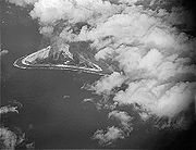
Geography
Minamitorishima is triangular in shape, and unusual in that it has an inverted-saucer like profile, with a raised outer rim of between 5 metres (16 ft) and 9 metres (30 ft) above sea level. The central area of the island is 1 metres (3 ft) below sea level. Minamitorishima is surrounded by a fringing reefReef
In nautical terminology, a reef is a rock, sandbar, or other feature lying beneath the surface of the water ....
which ranges from 50 metres (164 ft) to 300 metres (984 ft) in width, enclosing a shallow lagoon, which is connected with the open ocean by narrow passages on the southern and northeastern sides. Outside the reef, the ocean depths quickly plunge to over 1000 metres (3,280.8 ft). The island has a total land area of 1.2 square kilometre (0.463322590311042 sq mi).
The island also has the highest average temperature in Japan.
History
The first discovery and mention of an island in this area was made by a Spanish Manila GalleonManila Galleon
The Manila galleons or Manila-Acapulco galleons were Spanish trading ships that sailed once or twice per year across the Pacific Ocean between Manila in the Philippines, and Acapulco, New Spain . The name changed reflecting the city that the ship was sailing from...
captain, Captain Arriola in 1694. Its exact location was left unrecorded until further sightings in the early 19th century.
United States
The United States of America is a federal constitutional republic comprising fifty states and a federal district...
or the Kingdom of Hawaii
Kingdom of Hawaii
The Kingdom of Hawaii was established during the years 1795 to 1810 with the subjugation of the smaller independent chiefdoms of Oahu, Maui, Molokai, Lānai, Kauai and Niihau by the chiefdom of Hawaii into one unified government...
, and was given the name “Marcus Island”. Its position was recorded by a United States survey ship in 1874, and first landed on by a Japanese national, Kiozaemon Saito in 1879. On June 30, 1886 a Japanese named Shinroku Mizutani led a group of 46 colonists from Hahajima in the Ogasawara Islands to settle on Marcus Island. The settlement was named “Mizutani” after the leader of the expedition. The Empire of Japan
Empire of Japan
The Empire of Japan is the name of the state of Japan that existed from the Meiji Restoration on 3 January 1868 to the enactment of the post-World War II Constitution of...
officially annexed the island July 24, 1898, the previous United States claim from 1889 according to the Guano Islands Act
Guano Islands Act
The Guano Islands Act is federal legislation passed by the U.S. Congress, on August 18, 1856. It enables citizens of the U.S. to take possession of islands containing guano deposits. The islands can be located anywhere, so long as they are not occupied and not within the jurisdiction of other...
not being officially acknowledged. The island was official named “Minamitorishima” and placed administratively under the Ogasawara Subprefecture
Ogasawara Subprefecture
is a subprefecture of Tokyo, Japan. The subprefecture covers the Bonin Islands and includes the village of Ogasawara; and the prefectural government maintains a main office on Chichijima and a branch office on Hahajima....
of Tokyo
Tokyo
, ; officially , is one of the 47 prefectures of Japan. Tokyo is the capital of Japan, the center of the Greater Tokyo Area, and the largest metropolitan area of Japan. It is the seat of the Japanese government and the Imperial Palace, and the home of the Japanese Imperial Family...
.
Sovereignty over the island before World War I
World War I
World War I , which was predominantly called the World War or the Great War from its occurrence until 1939, and the First World War or World War I thereafter, was a major war centred in Europe that began on 28 July 1914 and lasted until 11 November 1918...
was apparently disputed as various sources from the time move the island from the American to Japanese domain without specific explanation. In 1902, the United States dispatched a warship from Hawaii to enforce its claims, but withdrew on finding the island still inhabited by Japanese, with a Japanese warship patrolling nearby. In 1914, William D. Boyce
William D. Boyce
William Dickson "W. D." Boyce was an American newspaper man, entrepreneur, magazine publisher, and explorer. He was the founder of the Boy Scouts of America and the short-lived Lone Scouts of America . Born in Allegheny County, Pennsylvania, he acquired a love for the outdoors early in his life...
included Marcus Island as an obviously American island in his book, The Colonies and Dependencies of the United States. In 1933, by orders of the Japanese government, the civilian inhabitants of Minamitorishima were evacuated. In 1935, the Imperial Japanese Navy
Imperial Japanese Navy
The Imperial Japanese Navy was the navy of the Empire of Japan from 1869 until 1947, when it was dissolved following Japan's constitutional renunciation of the use of force as a means of settling international disputes...
established a meteorological station on the island, and built an airstrip.
After the start of World War II
World War II
World War II, or the Second World War , was a global conflict lasting from 1939 to 1945, involving most of the world's nations—including all of the great powers—eventually forming two opposing military alliances: the Allies and the Axis...
the Japanese garrison
Garrison
Garrison is the collective term for a body of troops stationed in a particular location, originally to guard it, but now often simply using it as a home base....
stationed on the island consisted of the 742 man Minamitorishima Guard Unit, under the command of Rear-Admiral Masata Matsubara and the 2,005 man 12th Independent Mixed Regiment, under the command of Colonel Yoshiichi Sakata. The United States Navy
United States Navy
The United States Navy is the naval warfare service branch of the United States Armed Forces and one of the seven uniformed services of the United States. The U.S. Navy is the largest in the world; its battle fleet tonnage is greater than that of the next 13 largest navies combined. The U.S...
bombed it repeatedly in 1942 and in 1943, but never attempted to capture it (the island was featured in the U.S. training/propaganda film The Fighting Lady
The Fighting Lady
The Fighting Lady is a documentary/propaganda film produced by the U.S. Navy.The plot of the film revolves around the life of seamen on board an anonymous aircraft carrier. Because of war time restrictions, the name of the aircraft carrier was disguised as "the Fighting Lady"; afterwards the...
). Though isolated the Japanese were able to resupply the garrison by submarine
Submarine
A submarine is a watercraft capable of independent operation below the surface of the water. It differs from a submersible, which has more limited underwater capability...
, using a channel cut through the reef on the northwest side of the island. That channel is still visible today.
The Treaty of San Francisco
Treaty of San Francisco
The Treaty of Peace with Japan , between Japan and part of the Allied Powers, was officially signed by 48 nations on September 8, 1951, at the War Memorial Opera House in San Francisco, California...
transferred the island to American control.
The island was returned to Japanese control in 1968.
In 1964 the U.S. Coast Guard
United States Coast Guard
The United States Coast Guard is a branch of the United States Armed Forces and one of the seven U.S. uniformed services. The Coast Guard is a maritime, military, multi-mission service unique among the military branches for having a maritime law enforcement mission and a federal regulatory agency...
opened a LORAN-C
Marcus Island LORAN-C transmitter
Marcus Island LORAN-C transmitter is a LORAN-C transmitter on Marcus Island , Japan at...
navigation station on Marcus Island, whose mast was until 1985 one of the tallest structures in the Pacific area. In the 1980s the LORAN station was maintained by 23 "Coasties". They were based there on one-year tours with a visit to mainland Japan at the six-month point. While under U.S. administration, on Thursdays a C-130 Hercules
C-130 Hercules
The Lockheed C-130 Hercules is a four-engine turboprop military transport aircraft designed and built originally by Lockheed, now Lockheed Martin. Capable of using unprepared runways for takeoffs and landings, the C-130 was originally designed as a troop, medical evacuation, and cargo transport...
from the 345th Tactical Airlift Squadron, Yokota Air Base
Yokota Air Base
, is a United States Air Force base in the city of Fussa, one of 26 cities in the Tama Area, or Western Tokyo.The base houses 14,000 personnel. The base occupies a total area of and has a runway...
, Japan, would resupply the island on weekly missions. Often Coast Guardsmen would judge landings by raising placards with large numbers. An unusually long four-hour ground time was scheduled to allow technicians who flew in to perform maintenance on the transmitter and to offload extra fuel from the C-130 to power the island's generator. It also allowed the Coasties to read and answer letters while aircrews would snorkel
Snorkeling
Snorkeling is the practice of swimming on or through a body of water while equipped with a diving mask, a shaped tube called a snorkel, and usually swimfins. In cooler waters, a wetsuit may also be worn...
and collect green glass fishing buoys that wash up on the shore. It takes about 45 minutes to walk around the island.
The station was transferred from the U.S. Coast Guard to the Japan Maritime Self Defense Force (JMSDF) on September 30, 1993 and was closed on December 1, 2009.
The island is currently used for weather observation and has a radio station, but little else. Because of its isolation, it is of some interest to amateur radio hobbyists
Amateur radio
Amateur radio is the use of designated radio frequency spectrum for purposes of private recreation, non-commercial exchange of messages, wireless experimentation, self-training, and emergency communication...
. The JMSDF garrison is supplied by C-130 from Iruma Air Base
Iruma Air Base
is a Japan Air Self-Defense Force base located in the city of Sayama, Saitama Prefecture, north of western Tokyo, Japan.Iruma Air Base is currently home to the Air Defense Command Headquarters Flight Group...
, or by YS-11 from Haneda or Atsugi Air Base with flights via Iwo Jima
Iwo Jima
Iwo Jima, officially , is an island of the Japanese Volcano Islands chain, which lie south of the Ogasawara Islands and together with them form the Ogasawara Archipelago. The island is located south of mainland Tokyo and administered as part of Ogasawara, one of eight villages of Tokyo...
on a weekly basis. The runway of Minami Torishima Airport
Minami Torishima Airport
Minami Torishima Airport is a one runway airport serving the island of Minami Torishima. The airport used to be a military airstrip and according to the Japanese Aeronautical Information Service it is still operated by the Japan Maritime Self-Defense Force....
is only 1300 meters long, and cannot handle larger aircraft. The island is considered as a separate country for amateur radio awards. The island is off-limits to civilians, except from the Japan Meteorological Agency
Japan Meteorological Agency
The or JMA, is the Japanese government's weather service. Charged with gathering and reporting weather data and forecasts in Japan, it is a semi-autonomous part of the Ministry of Land, Infrastructure and Transport...
. Interestingly, its runway is sometimes obscured in aerial images of the island.
External links
- Minami Torishima info and pictures
- Marcus Island sunrise, sunset, tides
- Map and aerial photo of Minami Torishima, from the Geographical Survey Institute of Japan website
- Oceandots.com