
Nha Trang
Encyclopedia
Khanh Hoa Province
Khánh Hòa is a province of Vietnam, located in the South Central Coast. It has a population of 1,066,300 and spans an area of 5,197 km². Its capital is Nha Trang...
, on the South Central Coast
Nam Trung Bo
Nam Trung Bộ is one of the regions of Vietnam. It consists of the independent municipality of Đà Nẵng and seven other provinces. The two southern provinces Ninh Thuận and Bình Thuận are sometimes seen as part of the Southeast region.The region has traditionally been one of the main gateways to...
of Vietnam
Vietnam
Vietnam – sometimes spelled Viet Nam , officially the Socialist Republic of Vietnam – is the easternmost country on the Indochina Peninsula in Southeast Asia. It is bordered by China to the north, Laos to the northwest, Cambodia to the southwest, and the South China Sea –...
. It is bounded on the North by Ninh Hoà
Ninh Hoà
Ninh Hoà is a commune and village in Hồng Dân District, Bạc Liêu Province, in south-western Vietnam....
district, on the East by the South China Sea
South China Sea
The South China Sea is a marginal sea that is part of the Pacific Ocean, encompassing an area from the Singapore and Malacca Straits to the Strait of Taiwan of around...
, on the South by Cam Ranh
Cam Ranh
Cam Ranh is a city in southern Khanh Hoa province, in the South Central Coast of Vietnam. It is the second-largest city in the province, after Nha Trang. It is located on Cam Ranh Bay. As of 2009 the city had a population of 125.311. and covers an area of 316 km².Cam Ranh becomes the second...
town and on the West by Diên Khánh district. The city has about 300,000 inhabitants, a number which is projected to increase to between 500,000 and 600,000 inhabitants by 2020 according to an estimation of Nha Trang Administrative Board Statistics.
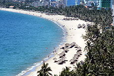
Nha Trang is well known for its pristine beaches and excellent scuba diving
Scuba diving
Scuba diving is a form of underwater diving in which a diver uses a scuba set to breathe underwater....
and is fast becoming a popular destination for international tourists, attracting large numbers of backpackers
Backpacking (travel)
Backpacking is a term that has historically been used to denote a form of low-cost, independent international travel. Terms such as independent travel and/or budget travel are often used...
as well as more affluent travellers on the Southeast Asia
Southeast Asia
Southeast Asia, South-East Asia, South East Asia or Southeastern Asia is a subregion of Asia, consisting of the countries that are geographically south of China, east of India, west of New Guinea and north of Australia. The region lies on the intersection of geological plates, with heavy seismic...
circuit. It is already very popular with Vietnamese tourists. Nha Trang Bay is widely considered as amongst the world's most beautiful bays. Tourists are welcome to participate in the Sea Festival, held biennially. Nha Trang was the site of the Miss Universe 2008
Miss Universe 2008
Miss Universe 2008, the 57th Miss Universe pageant, was held at the Crown Convention Center in the Diamond Bay Resort, Nha Trang, Vietnam on July 14, 2008...
Pageant on July 14, 2008 and Miss Earth 2010
Miss Earth 2010
Miss Earth 2010, the 10th edition of Miss Earth beauty pageant, was held at Vinpearl Land, Nha Trang, Vietnam on December 4, 2010.Eighty-four contestants from various countries and territories competed for the Miss Earth 2010 title. At the conclusion of the competition, outgoing titleholder Miss...
held December 4, 2010.Besides, Nha Trang was also approved to host 2016 Asian Beach Games
2016 Asian Beach Games
The Fifth Asian Beach Games will be held in Nha Trang, Vietnam in 2016.It will be the second time for Vietnam to host an Asia level multi-sports event, after Hanoi held Asian Indoor Games and Southeast Asian Games . However, it will be the first time that the event won't be held in Hanoi....
.
Historically, the city was known as Kauthara under the Champa
Champa
The kingdom of Champa was an Indianized kingdom that controlled what is now southern and central Vietnam from approximately the 7th century through to 1832.The Cham people are remnants...
. The city is still home to the famous Po Nagar
Po nagar
Po Nagar is a Cham temple tower founded sometime before 781 AD and located in the medieval principality of Kauthara, near modern Nha Trang in Vietnam...
Tower built by the Champa. Being a coastal city, Nha Trang is a centre for marine science based at the Nha Trang Oceanography Institute
Nha Trang Oceanography Institute
The Nha Trang Oceanography Institute or Institute of Oceanography in Nhatrang is an oceanography institute located at 1 Cau Da St., next to Cau Da Wharf, about 6km from the centre of Nha Trang, Khanh Hoa Province, Vietnam...
. The Hon Mun marine protected area is one of four first marine protected area
Marine Protected Area
Marine Protected Areas, like any protected area, are regions in which human activity has been placed under some restrictions in the interest of conserving the natural environment, it's surrounding waters and the occupant ecosystems, and any cultural or historical resources that may require...
s in the world admitted by the IUCN.
Commercial flights to Nha Trang no longer use the city's municipal airport, but fly to the larger Cam Ranh International Airport, a former U.S. Air Force Base (built during the Vietnam War) located approximately 35 km south of Nha Trang (see the Transport section below for additional details).
The French-Swiss bacteriologist Alexandre Yersin
Alexandre Yersin
Alexandre Emile Jean Yersin was a Swiss and French physician and bacteriologist. He is remembered as the co-discoverer of the bacillus responsible for the bubonic plague or pest, which was later re-named in his honour .Yersin was born in 1863 in Aubonne, Canton of Vaud, Switzerland, to a family...
(who discovered the Yersinia pestis
Yersinia pestis
Yersinia pestis is a Gram-negative rod-shaped bacterium. It is a facultative anaerobe that can infect humans and other animals....
bacterium) identified himself with Nha Trang's life for 50 years (affectionately known as Ông Năm). He established the Indochina Pasteur Institute (now known as the Nha Trang Pasteur Institute) devoted to research on the bubonic plague
Bubonic plague
Plague is a deadly infectious disease that is caused by the enterobacteria Yersinia pestis, named after the French-Swiss bacteriologist Alexandre Yersin. Primarily carried by rodents and spread to humans via fleas, the disease is notorious throughout history, due to the unrivaled scale of death...
. Yersin died in Nha Trang on 1 March 1943. A street in the city is named after him, there is a shrine located next to his tomb, and his house has been converted into the Yersin Museum
Yersin Museum
The Yersin Museum is a museum in Nha Trang, Vietnam. It is dedicated to Alexandre Yersin the bacteriologist.It is located on 8 - 10 Tran Phu boulevard in the former home of Yersin in the enclosure of the Pasteur Institute ....
.
Geography and climate
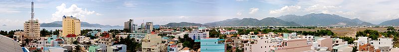
Nha Trang city has a metropolitan area of 251 km² and population of about 500,000 . It borders Ninh HòaNinh Hoa
Ninh Hòa is a district-level town of Khanh Hoa province in the South Central Coastal region of Vietnam. As of 2003 the town had a population of 227,630. The district covers an area of 1,199 km²...
town by the north, Cam Ranh
Cam Ranh
Cam Ranh is a city in southern Khanh Hoa province, in the South Central Coast of Vietnam. It is the second-largest city in the province, after Nha Trang. It is located on Cam Ranh Bay. As of 2009 the city had a population of 125.311. and covers an area of 316 km².Cam Ranh becomes the second...
city by the south, Diên Khánh
Dien Khanh
Dien Khanh is a district of Khanh Hoa Province in the South Central Coastal region of Vietnam.-Dien Khanh Citadel:The Dien Khanh Citadel is situated on Dien Khanh Townlet, Dien Khanh District, Khanh Hoa Province...
town by the west and the South China Sea
South China Sea
The South China Sea is a marginal sea that is part of the Pacific Ocean, encompassing an area from the Singapore and Malacca Straits to the Strait of Taiwan of around...
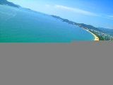
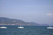
to the east. The city is located on the beautiful Nha Trang Bay, which was chosen by Travel and Leisure in two succeeding years as one of 29 most beautiful bays in the world. Nha Trang is surrounded on all three sides by mountains and a large island on the fourth side (in the ocean directly in front of the city's main area), blocking major storms from potentially damaging the city.
Nha Trang has a tropical savanna climate
Tropical savanna climate
Tropical savanna climate or tropical wet and dry climate is a type of climate that corresponds to the Köppen climate classification categories "Aw" and '"As."...
with a lengthy dry season from January to August and a shorter wet season from September to December, when 1029 millimetres (41 in) of the city’s total annual rainfall of 1361 millimetres (54 in) is received from the northeast monsoon. During the wet season extremely heavy rainfall from typhoons is not uncommon, though the city is shielded from the worst winds.
History
From 1653 to the 19th century, Nha Trang was a deserted area rich in wildlife (animals like tigers) and was a part of Hà Bạc, Vĩnh Xương County, Diên Khánh Province. After just two decades in the early 20th century, Nha Trang underwent a rapid change. On 30 August 1924, the Governor-General of French IndochinaGovernor-General of French Indochina
-External links:*...
decreed Nha Trang as a townlet (centre urbain). Nha Trang Townlet was established from the ancient villages of Xương Huân, Phương Câu, Vạn Thạnh, Phương Sài, and Phước Hải.
During French Indochina
French Indochina
French Indochina was part of the French colonial empire in southeast Asia. A federation of the three Vietnamese regions, Tonkin , Annam , and Cochinchina , as well as Cambodia, was formed in 1887....
, Nha Trang was seen as de facto
De facto
De facto is a Latin expression that means "concerning fact." In law, it often means "in practice but not necessarily ordained by law" or "in practice or actuality, but not officially established." It is commonly used in contrast to de jure when referring to matters of law, governance, or...
capital of Khanh Hoa Province
Khanh Hoa Province
Khánh Hòa is a province of Vietnam, located in the South Central Coast. It has a population of 1,066,300 and spans an area of 5,197 km². Its capital is Nha Trang...
. The colonial administration offices (like Envoy Office, Commanding Office, Trade Office, Post Office) were situated in Nha Trang. Local royal offices like Province Chief, Provincial Judge, Military Commander are in Dien Khanh city (a walled military city 10 km southwest of Nha Trang).
On 7 May 1937, the Governor-General of French Indochina
Governor-General of French Indochina
-External links:*...
by another decree upgraded Nha Trang Townlet to town. At this time, Nha Trang Town had five wards based on the ancient villages merged to make the town: Xương Huân, Phương Câu, Vạn Thạnh, Phương Sài, and Phước Hải.
On 27 January 1958, the president of the Republic of Vietnam, Ngô Đình Diệm by Decree 18-BNV abrogated the town status of Nha Trang and divided Nha Trang into two rural communes: Nha Trang Đông (Eastern Nha Trang) and Nha Trang Tây (Western Nha Trang), under the administration of Vĩnh Xương County.
On 22 October 1970, the government of the Republic of Vietnam by Decree 132-SL/NV reestablished Nha Trang Town on the ground of Nha Trang Đông and Nha Trang Tây and other rural communes, namely Vĩnh Hải, Vĩnh Phước, Vĩnh Trường, Vĩnh Nguyên, and villages Phước Hải (Vĩnh Thái Commune), Vĩnh Điềm Hạ (Vĩnh Hiệp Commune), Ngọc Thảo, Ngọc Hội, Lư Cấm Villages (Vĩnh Ngọc Commune) under the administration of Vinh Xuong County, together with islands Hòn Lớn, Hòn Một, Hòn Mun, Hòn Miễu, Hòn Tằm. Nha Trang Town was made the capital of Khanh Hoa Province. The town included two districts. District 1 covered communes Nha Trang Đông, Vĩnh Hải, Vĩnh Phước, and villages Ngọc Thảo, Ngọc Hội and Lư Cấm of Vĩnh Ngọc Commune, Vĩnh Điềm Hạ village of Vĩnh Hiệp Commune. District 2 covered communes Nha Trang Tây, Vĩnh Trường, Vĩnh Nguyên (inclusive of islands of Hòn Tre, Hòn Một, Hòn Mun, Hòn Tằm), Phước Hải village of Vĩnh Thái Commune.
Following that establishment, the government by Decree 357-ĐUHC/NC/NĐ dated 5 June 1971 divided Nha Trang into 11 urban zones, of which, district 1 covered urban zones of Vĩnh Hải, Vĩnh Phước, Ngọc Hiệp, Vạn Thạnh, Duy Tân; district 2 covered urban wards of Vĩnh Nguyên, Vĩnh Trường, Phương Sài, Tân Phước, Tân Lập, Phước Hải. Decree 553-BNV/HCĐP/NV dated 22 August 1972 renamed urban zones into urban wards. Decree 444-BNV/HCĐP/26.X dated 3 September 1974 merged islands of Hòn Một, Hòn Cậu, Hòn Đụn, Hòn Chóp Vung, Hòn Đỏ into Vĩnh Hải ward (district 1) and Hòn Ngọc into Vĩnh Nguyên ward (district 2) of Nha Trang Town.
On 2 April 1975, communist (NLF/PRG/VPA
Vietnam People's Army
The Vietnam People's Army is the armed forces of Vietnam. The VPA includes: the Vietnamese People's Ground Forces , the Vietnam People's Navy , the Vietnam People's Air Force, and the Vietnam Marine Police.During the French Indochina War , the VPA was often referred to as the Việt...
) forces captured the city. On 4 April 1975, Khanh Hoa Military Commission (Ủy ban Quân quản Khánh Hòa) divided Nha Trang into three administrative districts: District 1, District 2 and Vĩnh Xương District.
In September 1975, District 1 and District 2 were merged to become one entity, the town of Nha Trang.
On 30 March 1977, the Council of the Government (now the cabinet) of the Socialist Republic of Vietnam by Decision 391-CP/QĐ upgraded Nha Trang to city status, a county-level city under the administration of Phu Khanh Province (a province created by merger of now Phú Yên Province and Khánh Hòa Province
Khanh Hoa Province
Khánh Hòa is a province of Vietnam, located in the South Central Coast. It has a population of 1,066,300 and spans an area of 5,197 km². Its capital is Nha Trang...
). Seven communes of former Vĩnh Xương County, namely Vĩnh Thái, Vĩnh Ngọc, Vĩnh Hiệp, Vĩnh Lương, Vĩnh Trung, Vĩnh Thạnh, Vĩnh Phương was split from Khánh Xương County to become Nha Trang City territory.
On 27 March 1978, the provincial government by Decision 54-BT founded Phước Đồng Commune under Nha Trang City.
On 1 July 1989, Khanh Hoa was split from Phu Khanh Province to become Khanh Hoa Province
Khanh Hoa Province
Khánh Hòa is a province of Vietnam, located in the South Central Coast. It has a population of 1,066,300 and spans an area of 5,197 km². Its capital is Nha Trang...
as it was before, Nha Trang was made the capital of Khanh Hoa Province.
On 22 April 1999, the prime minister by Decision 106/1999 recognised Nha Trang City the second class municipal city.
Administrative divisions
Origin of the name
According to some researches, the name Nha Trang derives from a false Vietnamese spelling of a geographical name in the Cham languageCham language
Cham is the language of the Cham people of Southeast Asia, and formerly the language of the kingdom of Champa in central Vietnam. A member of the Malayo-Polynesian branch of the Austronesian family, it is spoken by 100,000 people in Vietnam and up to 220,000 people in Cambodia . There are also...
of the site Ya Trang (lit. Reed River), the name of the now Cai River as referred to by the Cham people. From the name of this river, the name was adopted to call what is now Nha Trang, which was officially made Vietnam's territory in 1653.
As far as the recorded naming of Nha Trang is concerned, in Toàn tập Thiên Nam Tứ Chí Lộ Đồ Thư, a geographical book written by a Vietnamese scholar with the family of Đỗ Bá in the second half of the 18th century, the name Nha Trang Môn ("Nha Trang gate") was mentioned. In another map dating to the 17th century, known as Giáp Ngọ Niên Bình Nam Đồ by a noble called Đoan Quận công Bùi Thế Đạt, the name Nha Trang Hải môn (Nha Trang Sea Gate) was also cited. In Vietnamese recorded historic bibliographies, these books are perhaps the earliest ones that mentioned this place name.
In a work by Lê Quý Đôn called Phủ biên tạp lục (1776), many Nha Trang-related names were also mentioned, such as đầm Nha Trang, dinh Nha Trang, nguồn Nha Trang, and đèo Nha Trang.
Education
Nha Trang is home to a multidisciplinary university, Nha Trang UniversityNha Trang University
Nha Trang University is a university in Nha Trang, Khanh Hoa Province, in Vietnam's South Central Coast. This a multidisciplinary university with 23 specialities from vocational training to doctor’s degree.-History:...
(formerly Nha Trang Fishery University); Naval Academy; Air Force Academy; Normal (Teacher's) College; Kindergarten Teacher's Training College; and Arts and Tourism College. The city is home to the many high schools. Nha Trang Oceanography Institute
Nha Trang Oceanography Institute
The Nha Trang Oceanography Institute or Institute of Oceanography in Nhatrang is an oceanography institute located at 1 Cau Da St., next to Cau Da Wharf, about 6km from the centre of Nha Trang, Khanh Hoa Province, Vietnam...
, the unique institute of oceanography in Vietnam, Nha Trang Pasteur Institute one of the famous Pasteur Institute
Pasteur Institute
The Pasteur Institute is a French non-profit private foundation dedicated to the study of biology, micro-organisms, diseases, and vaccines. It is named after Louis Pasteur, who made some of the greatest breakthroughs in modern medicine at the time, including pasteurization and vaccines for anthrax...
s in Vietnam are located in Nha Trang.
Transport
When Cam Ranh BayCam Ranh Bay
Cam Ranh Bay is a deep-water bay in Vietnam in the province of Khánh Hòa. It is located at an inlet of the South China Sea situated on the southeastern coast of Vietnam, between Phan Rang and Nha Trang, approximately 290 kilometers / 180 miles northeast of Hồ Chí Minh City / Saigon.Cam Ranh is...
used to be an important naval base, Nha Trang Airport
Nha Trang Airport
Nha Trang Airport may refer to the 2 airports serving Nha Trang, Khanh Hoa, Vietnam.* Cam Ranh International Airport - for civil use* Nha Trang Air Base - previously used for both civil and military purposes, but civil use has been transferred to Cam Ranh Airport...
was the main airport of the city. This airport was used by the United States Air Force and South Vietnam Air Force during the Vietnam War
Vietnam War
The Vietnam War was a Cold War-era military conflict that occurred in Vietnam, Laos, and Cambodia from 1 November 1955 to the fall of Saigon on 30 April 1975. This war followed the First Indochina War and was fought between North Vietnam, supported by its communist allies, and the government of...
. When part of Cam Ranh Bay was made an economic development zone by the Vietnamese government, Cam Ranh International Airport (also a military airport built by the United States during Vietnam War) was made the new civilian airport of the city. This airport is located by Cam Ranh Bay, 45 km (28 mi) south of the city and is currently (as of 2007) the forth busiest airport in terms of passenger traffic in Vietnam serving more than 683.000 passengers in 2008.
The city is located next to the National Road 1A, the backbone north-south road of the country. The Reunification Railway
North-South Railway, Vietnam
The Vietnam North-South Railway, also known as the Reunification Express, is a railway that runs from Ha Noi to Ho Chi Minh City. The total length of this railway is , with a gauge of metre gauge...
also crosses the city and stops at Nha Trang Railway Station
Nha Trang Railway Station
Nha Trang Railway Station is one of the main railway stations on the North-South Railway in Vietnam. It serves the city of Nha Trang....
. The construction work of Van Phong Port
Van Phong Port
Van Phong Port is a deep water port planned for development in Van Phong Bay, north of Nha Trang, Khanh Hoa Province, Vietnam. Van Phong Bay has a natural average depth of 22 to 27 metres and is naturally protected by the Hòn Gốm Peninsula....
, north of the city, a deep-water project capable of handling ships up to 100,000 tonnes, and with a capacity of 100 million tonnes of cargo per annum, is under progress by a consortium of Japanese corporations. The estimated investment capital for this port-city complex project is expected to reach US$15 billion.
Economy
Nha Trang's economy relies largely on tourismTourism
Tourism is travel for recreational, leisure or business purposes. The World Tourism Organization defines tourists as people "traveling to and staying in places outside their usual environment for not more than one consecutive year for leisure, business and other purposes".Tourism has become a...
. In the suburban areas around the city, the shipbuilding
Shipbuilding
Shipbuilding is the construction of ships and floating vessels. It normally takes place in a specialized facility known as a shipyard. Shipbuilders, also called shipwrights, follow a specialized occupation that traces its roots to before recorded history.Shipbuilding and ship repairs, both...
industry has developed and contributed significantly to the city's economy. Fishery and services are also important to the city. Khanh Hoa Province in general and Nha Trang is particular are among the largest contributors to Vietnam's annual budget revenues. Lobster farming on the sea is an important industry for the people living in suburb areas of the city. To the south of the city, by Cam Ranh Bay, several industrial parks are under construction and have been partly available for investors. Once the construction of the deep-water port on Van Phong Bay has been completed, this area will become the third important economic zone in the province (besides Nha Trang and Cam Ranh).
Tourism

Lying off Nha Trang is the Hon Tre Island (Bamboo Island), with a major resort operated by the Vinpearl Group. The Vinpearl Cable Car, a gondola lift
Gondola lift
A gondola lift is a type of aerial lift, normally called a cable car, which is supported and propelled by cables from above. It consists of a loop of steel cable that is strung between two stations, sometimes over intermediate supporting towers. The cable is driven by a bullwheel in a terminal,...
system, links the mainland to the five-star resort and theme park on Hon Tre Island.
Nha Trang is a stopover for annual yacht races starting in Hong Kong
Hong Kong
Hong Kong is one of two Special Administrative Regions of the People's Republic of China , the other being Macau. A city-state situated on China's south coast and enclosed by the Pearl River Delta and South China Sea, it is renowned for its expansive skyline and deep natural harbour...
. In recent years, the city has welcomed many five-star sea cruises. In addition to sail boat racing, Nha Trang provides a rich variety of tourist activities for visitors. Island hopping, scuba diving, water sports and other sporting activities can be enjoyed in the city. The Nha Trang Tourist Information Center (a non-governmental organisation), located near the Cho Dam Market has been set up to provide information for visitors.
The local cuisine is most famous for fresh seafoods and barbecued pork rolled in rice paper. The area's Bird's nest soup
Bird's nest soup
Bird's nest soup is a delicacy in Chinese cuisine. A few species of swift, the cave swifts, are renowned for building the saliva nests used to produce the unique texture of this soup....
is deemed one of the best in Vietnam. Bird's nests are collected in the wild, on bird farms on the islands off the coast and even in some houses in the inner city. The farmed bird in question belongs to the swiftlet
Swiftlet
Swiftlets are birds contained within the four genera Aerodramus, Hydrochous, Schoutedenapus and Collocalia. They form the Collocaliini tribe within the swift family Apodidae. The group contains around thirty species mostly confined to southern Asia, south Pacific islands, and northeastern...
group, popularly referred to as yến hàng (Aerodramus fuciphagus germani).
Long Son Pagoda
Long Son Pagoda
Long Sơn Pagoda is a Buddhist temple in the city of Nha Trang on south central coast of Vietnam. It is regarded as one of the main sites in the city, along with Hai Duc Temple.- History :...
is prominent for its statue of Gautama Buddha
Gautama Buddha
Siddhārtha Gautama was a spiritual teacher from the Indian subcontinent, on whose teachings Buddhism was founded. In most Buddhist traditions, he is regarded as the Supreme Buddha Siddhārtha Gautama (Sanskrit: सिद्धार्थ गौतम; Pali: Siddhattha Gotama) was a spiritual teacher from the Indian...
.
Recreation and nightlife
Scuba diving, kite boarding are available, as are catamaran sailboats. Winds are steady.The nightlife is limited, but near the Biet Thu tourist district, it can go beyond midnight. The nightlife is therefore known as superior to other coastal towns such as Mui Ne, Da Nang
Da Nang
Đà Nẵng , occasionally Danang, is a major port city in the South Central Coast of Vietnam, on the coast of the South China Sea at the mouth of the Han River. It is the commercial and educational center of Central Vietnam; its well-sheltered, easily accessible port and its location on the path of...
and Vũng Tàu
Vung Tàu
Vũng Tàu is a city in southern Vietnam. Its population in 2005 was 240,000. The city area is including 13 urban wards and one village. It is the capital of Ba Ria-Vung Tau province, and is the crude oil extraction center of Vietnam. It is also known as one of the most beautiful cities of tourism...
. It is usually busiest around the Vietnamese New Year period, but can still be worth visiting any time of year, with the possible exception of the rain period (especially November). A lot of tourists are enjoying the Nha Trang River Cai boat ride (locally known as Song Cai, as "song" means "river" in the Vietnamese language).
Tourist attractions
- Alexandre Yersin Museum
- Boat tour on Cai River, visiting islands off the coast and Ba Ho Waterfall.
- Palace of Emperor Bảo ĐạiBảo ĐàiBảo Đài is a commune and village in Lục Nam District, Bac Giang Province, in northeastern Vietnam.-References:...
- Thap Ba Hot Spring (Lady Tower hot spring)
- Nha Phu Lagoon
- Hoa Lan Stream (Orchid Flower tream)
- Monkey Island
- Sạn Beach
- Nha Trang Booze Cruise (All you can Drink Party Boat)
- Hòn Tằm Island (Silkworm island)
- Hòn Mun Island (Ebony island)
- Hòn Con Sẻ Tre Island (Bamboo Sparraw island)
- Hòn Ông Island
- Đảo Yến Island (Swiftlet island)
- Hòn Tre Island (Bamboo island)
- Suối Đổ Stream
- Suối Tiên Stream (Fairy stream)
- Hòn Bà Mountain
- Cai River Minigolf & Restaurant & Marina
- Yangbay Waterfall
- Tháp Bà Pô Nagar Nha Trang (a Champa Tower)
- Chùa Long Sơn (Long Son Pagoda- literral: The Dragon Mountain pagoda or White Buddha Pagoda)
- Nha Trang Oceanography InstituteNha Trang Oceanography InstituteThe Nha Trang Oceanography Institute or Institute of Oceanography in Nhatrang is an oceanography institute located at 1 Cau Da St., next to Cau Da Wharf, about 6km from the centre of Nha Trang, Khanh Hoa Province, Vietnam...
, the largest of its kind in IndochinaIndochinaThe Indochinese peninsula, is a region in Southeast Asia. It lies roughly southwest of China, and east of India. The name has its origins in the French, Indochine, as a combination of the names of "China" and "India", and was adopted when French colonizers in Vietnam began expanding their territory...
where thousands of oceanic life samples, exhibits are on display. It is also home to the largest oceanic library in Vietnam. - Chánh Tọa Church (or Mountain Church)
- Nha Trang Pasteur Institute
- Trí Nguyên Aquarium (an aquarium where hundreds of rare oceanic species are fed)
- Vinpearl Cable Car
Cuisine

Banh canh
Bánh canh is a thick Vietnamese noodle that can be made from a mixture of rice and tapioca flour. In bánh canh soup dishes, the noodles are combined with one of several soup bases, such as:...
with fish sausage) and bún cá sứa (rice vermicelli with jelly fish).
Gallery
File:Hon Chong from Co Tien beach.JPG|Hon Chong rocks
File:Crown Convention Center.JPG|The official venue of Miss Universe 2008
Miss Universe 2008
Miss Universe 2008, the 57th Miss Universe pageant, was held at the Crown Convention Center in the Diamond Bay Resort, Nha Trang, Vietnam on July 14, 2008...
pageant
File:NhaTrangBay.JPG|Nha Trang Bay
File:Bình đài ở tháp Ponagar, Nha Trang.JPG|Another view at Po Nagar temple
File:Durga ornament Po Nagar.jpg|A Durga ornament
File:Nha Trang, Long Son pagoda.jpg|Long Son pagoda
File:Nha Trang-Tran Phu.JPG|A typical street in Nha Trang City
File:Nha Trang.jpg|Bridges
File:Nhatrang Oceanographic Institute.jpg|Oceanographic Institute
File:IMG 2611 Nha Trang.jpg|Another view
File:NhaTrangHarbour.JPG|The fishing harbour
File:Sea anemone, Nha Trang.jpg|Sea anemone