
Typhoon Durian
Encyclopedia
Typhoon Durian was an intense storm that wreaked havoc in the Philippines
, causing massive loss of life when mudslides from the Mayon Volcano
buried many villages. According to the Joint Typhoon Warning Center
, Durian was the 24th tropical depression, 23rd tropical storm, 14th typhoon and 7th super typhoon of the 2006 Pacific typhoon season
. It was also the 21st named storm and 14th typhoon of the season recognised by the Regional Specialized Meteorological Centre
for tropical cyclone
s in this region, the Japan Meteorological Agency
. The name Durian was submitted to the naming list by Thailand
, which refers to a fruit, Durio zibethinus
.
Durian first made landfall in the Philippines
packing strong winds and heavy rains that caused mudslides near Mayon Volcano
. After causing massive damage in the Philippines, it exited into the South China Sea
and weakened slightly, before managing to reorganise and restrengthen into a typhoon shortly before its second landfall, this time in Vietnam
near Thành phố Hồ Chí Minh
, causing further damage of more than US$400 million. In all, Durian killed at least 1,497 people, and left hundreds more missing. Damages from the typhoon were estimated at over $13 billion (2006 USD).
(formerly Truk) on November 24. Wind shear
near the disturbance soon decreased, allowing the depression to organize a little. It was designated a tropical depression by Japan Meteorological Agency
on November 25, and later that day the Joint Typhoon Warning Center
started issuing warnings on the system as it moved west-northwest towards Yap
. The depression strengthened because it was in an area of high sea-surface temperatures, and there were distinct cloud features of anticyclonic
outflow, according to the JMA. It was upgraded to a tropical storm on the afternoon of November 26 and named Durian.
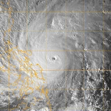
Moving west to west-northwestward, Durian intensified slowly. It became a severe tropical storm on November 27, and the next day it was named Reming by PAGASA
when it entered the Philippine Area of Responsibility. Later on November 28, both the JMA and JTWC upgraded it to a typhoon as it continued to track towards the Philippines
. Rapid intensification
occurred on November 29, causing the JMA to upgrade the storm to 100 knots in wind intensity, and the JTWC to give it a Dvorak classification
of 6.5 (127 kt) in a satellite
fix. In 6 hours, Durian intensified from 90 kt 1-minute sustained winds to 125 kt. Durian began to weaken slightly as it approached land, undergoing an eyewall replacement cycle
, but quickly regained peak strength.
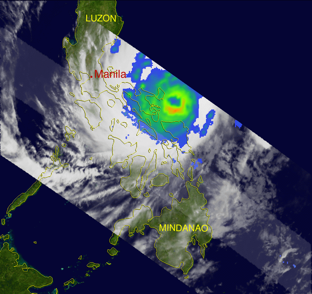
PAGASA claimed that the storm made landfall on the morning of November 30 over southern Catanduanes
, although the JMA and JTWC did not recognise this landfall. Durian then made another landfall after crossing the Lagonoy Gulf
in northeastern Camarines Sur
. After weakening due to interaction with land, Durian was downgraded back to a typhoon by the JTWC. The storm continued to move west, making landfalls on the Bondoc Peninsula
in Quezon
, on Marinduque
and finally on Oriental Mindoro
before exiting to the South China Sea
.
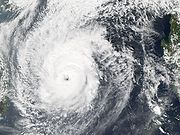
Encountering dry air entrainment and vertical wind shear
, Durian weakened slightly at first, but slowly began to reorganise and restrengthen as it neared Vietnam
. Durian began to turn slightly southwest towards Nha Trang
and Ho Chi Minh City
on December 3. Eventually, Durian began to weaken again, and by December 4, the JMA downgraded it to a severe tropical storm. The storm maintained intensity as it skirted the Vietnamese coast moving southwest. After a brief second stint at typhoon strength, Durian finally made landfall in Ben Tre Province
on December 5. The system rapidly weakened over land, and the JMA downgraded it to a tropical storm. The JMA and JTWC issued their final advisories later that day as Durian emerged into the Gulf of Thailand
as a weak tropical depression. The remnants of Durian then crossed the coast of southern Thailand
as it moved into the Bay of Bengal
.
Officials ordered the evacuation of citizens along coastal areas. In nearby Naga City, about 1,500 citizens left for emergency shelters. 1,000 were evacuated elsewhere in the region, including 120 in the capital city of Manila
and more than 800 in Legazpi City
. In and around Manila, officials closed schools and canceled at least 11 flights at the Ninoy Aquino International Airport
, including 9 domestic flights. The Coast Guard
grounded all vessels on open waters, stranding around 4,000 ferry passengers in Quezon
province. 25 provinces in the archipelago were placed on storm alert.
, officials ordered residents in high-risk areas to evacuate; more than 14,000 in Phu Yen Province left their homes for high schools and government buildings set up as shelters.
 Upon making landfall, the powerful winds of the hurricane blew away houses, uprooted trees, and left tens of thousands of residents without power. Widespread flooding was reported in Legazpi City
.
The typhoon produced heavy rainfall across its path, with localized totals reaching over 18 inches in Albay
province. Earlier eruptions of Mayon Volcano
combined with the rainfall to result in widespread mudslides across the province.
The next day, reports of deaths or injuries had not reached the media centres. Two weeks later, the death toll had risen to at least 720.
Final death toll is not known, because large areas buried by major lahar
s around Mayon cannot be excavated.
, killing two with one missing. In Binh Thuan Province
alone, 820 boats sank, and throughout the country 896 fishing boats sank.
Heavy rainfall from the typhoon destroyed 22 schools and 1,120 houses in Binh Thuan Province
. Strong winds from Durian blew off the roofs of about 500 houses in Bà Rịa – Vũng Tàu Province. Throughout the nation, the passage of the typhoon destroyed 34,000 homes, with an additional 166,000 damaged. Typhoon Durian killed 98 in the country and injured 1,770 others. http://www.reliefweb.int/rw/RWB.NSF/db900SID/KHII-6XRA2Q?OpenDocument&rc=3&emid=TC-2006-000175-PHL
Gloria Macapagal-Arroyo
declared a state of calamity in the Philippines, ordering the immediate release of 1 billion Philippine peso
s ($20.7 million, 2006 USD
) for relief in areas affected by Durian, Typhoon Xangsane
, and Typhoon Cimaron. This relief fund was increased to 3.6 billion pesos ($74.8 million, 2006 USD) on December 6, including an additional 150 million pesos ($3.1 million) for power grid repair.
The international response came shortly after the calamity status was declared. On December 3, Canada
released $1 million ($860,000 USD) for local relief through its embassy in Manila and through the International Red Cross and Red Crescent Movement
. UNICEF donated 4,000 packages containing food, mattresses, and blankets, and UNOCHA
donated $1– 2 million (USD) for relief supplies. Spain
donated $250,000 (USD) and sent medical teams, medicines, food, and supplies to affected areas. The United States
donated $250,000 plus supplies through the USAID program, and the Filipino community on Saipan
contributed cash, food, and supplies. Australia
released $1 million ($792,000 USD) through its AusAID
program. Indonesia
sent two C-130 Hercules
aircraft to Legazpi City
, carrying a total of 25 ton
s of food, medicine, and clothing valued at 1.17 billion Indonesian rupiah
($129,000 USD). Japan
pledged tents, blankets, generators, and water management equipment through the Japan International Cooperation Agency
. Malaysia donated 20 tons of food and medicines, and Singapore
sent two batches of supplies valued at $50,000 (USD) through Singapore Airlines
. The Republic of Korea pledged $100,000 (USD) cash, while the People's Republic of China
pledged $200,000 (USD). Israel
donated $7,500 (USD), mostly in medicines and medical supplies.
, the national government
released 150 billion Vietnamese đồng ($9 million, 2006 USD) in food and supplies to families in affected areas. The United States donated $100,000 (USD), and its Oxfam
organisation donated $200,000 (USD) to the most affected provinces. The International Red Cross and Red Crescent Movement
launched an emergency appeal for $2.47 million (USD) to support the efforts of the Vietnam Red Cross, which distributed over 2,000 packets of supplies and over 2 tonne
s of rice, medicine, and clothes.
in December 2006 that the name Durian, along with four others, would be retired from the name list. In December 2007, the committee selected the name Mangkhut to replace Durian on the Western Pacific basin name lists beginning in 2008
. Its PAGASA name, Reming, was also retired by PAGASA. In 2010 the name selected by PAGASA to replace Reming was Ruby.
Philippines
The Philippines , officially known as the Republic of the Philippines , is a country in Southeast Asia in the western Pacific Ocean. To its north across the Luzon Strait lies Taiwan. West across the South China Sea sits Vietnam...
, causing massive loss of life when mudslides from the Mayon Volcano
Mayon Volcano
Mayon Volcano, also known as Mount Mayon, is an active volcano in the province of Albay, on the island of Luzon in the Philippines. Renowned as the "perfect cone" because of its almost symmetric conical shape, Mayon forms the northern boundary of Legazpi City, the largest city in terms of...
buried many villages. According to the Joint Typhoon Warning Center
Joint Typhoon Warning Center
The Joint Typhoon Warning Center is a joint United States Navy – United States Air Force task force located at the Naval Maritime Forecast Center in Pearl Harbor, Hawaii...
, Durian was the 24th tropical depression, 23rd tropical storm, 14th typhoon and 7th super typhoon of the 2006 Pacific typhoon season
2006 Pacific typhoon season
The 2006 Pacific typhoon season had no official bounds; it ran year-round in 2006, but most tropical cyclones tend to form in the northwestern Pacific Ocean between May and November...
. It was also the 21st named storm and 14th typhoon of the season recognised by the Regional Specialized Meteorological Centre
Regional Specialized Meteorological Centre
A Regional Specialized Meteorological Centre is responsible for the distribution of information, advisories, and warnings regarding the specific program they have a part of, agreed by consensus at the World Meteorological Organization as part of the World Weather Watch.-Tropical...
for tropical cyclone
Tropical cyclone
A tropical cyclone is a storm system characterized by a large low-pressure center and numerous thunderstorms that produce strong winds and heavy rain. Tropical cyclones strengthen when water evaporated from the ocean is released as the saturated air rises, resulting in condensation of water vapor...
s in this region, the Japan Meteorological Agency
Japan Meteorological Agency
The or JMA, is the Japanese government's weather service. Charged with gathering and reporting weather data and forecasts in Japan, it is a semi-autonomous part of the Ministry of Land, Infrastructure and Transport...
. The name Durian was submitted to the naming list by Thailand
Thailand
Thailand , officially the Kingdom of Thailand , formerly known as Siam , is a country located at the centre of the Indochina peninsula and Southeast Asia. It is bordered to the north by Burma and Laos, to the east by Laos and Cambodia, to the south by the Gulf of Thailand and Malaysia, and to the...
, which refers to a fruit, Durio zibethinus
Durian
The durian is the fruit of several tree species belonging to the genus Durio and the Malvaceae family . Widely known and revered in southeast Asia as the "king of fruits", the durian is distinctive for its large size, unique odour, and formidable thorn-covered husk...
.
Durian first made landfall in the Philippines
Philippines
The Philippines , officially known as the Republic of the Philippines , is a country in Southeast Asia in the western Pacific Ocean. To its north across the Luzon Strait lies Taiwan. West across the South China Sea sits Vietnam...
packing strong winds and heavy rains that caused mudslides near Mayon Volcano
Mayon Volcano
Mayon Volcano, also known as Mount Mayon, is an active volcano in the province of Albay, on the island of Luzon in the Philippines. Renowned as the "perfect cone" because of its almost symmetric conical shape, Mayon forms the northern boundary of Legazpi City, the largest city in terms of...
. After causing massive damage in the Philippines, it exited into the South China Sea
South China Sea
The South China Sea is a marginal sea that is part of the Pacific Ocean, encompassing an area from the Singapore and Malacca Straits to the Strait of Taiwan of around...
and weakened slightly, before managing to reorganise and restrengthen into a typhoon shortly before its second landfall, this time in Vietnam
Vietnam
Vietnam – sometimes spelled Viet Nam , officially the Socialist Republic of Vietnam – is the easternmost country on the Indochina Peninsula in Southeast Asia. It is bordered by China to the north, Laos to the northwest, Cambodia to the southwest, and the South China Sea –...
near Thành phố Hồ Chí Minh
Ho Chi Minh City
Ho Chi Minh City , formerly named Saigon is the largest city in Vietnam...
, causing further damage of more than US$400 million. In all, Durian killed at least 1,497 people, and left hundreds more missing. Damages from the typhoon were estimated at over $13 billion (2006 USD).
Meteorological history
An area of disturbed weather developed southeast of ChuukChuuk
Chuuk — formerly Truk, Ruk, Hogoleu, Torres, Ugulat, and Lugulus — is an island group in the south western part of the Pacific Ocean. It comprises one of the four states of the Federated States of Micronesia , along with Kosrae, Pohnpei, and Yap. Chuuk is the most populous of the FSM's...
(formerly Truk) on November 24. Wind shear
Wind shear
Wind shear, sometimes referred to as windshear or wind gradient, is a difference in wind speed and direction over a relatively short distance in the atmosphere...
near the disturbance soon decreased, allowing the depression to organize a little. It was designated a tropical depression by Japan Meteorological Agency
Japan Meteorological Agency
The or JMA, is the Japanese government's weather service. Charged with gathering and reporting weather data and forecasts in Japan, it is a semi-autonomous part of the Ministry of Land, Infrastructure and Transport...
on November 25, and later that day the Joint Typhoon Warning Center
Joint Typhoon Warning Center
The Joint Typhoon Warning Center is a joint United States Navy – United States Air Force task force located at the Naval Maritime Forecast Center in Pearl Harbor, Hawaii...
started issuing warnings on the system as it moved west-northwest towards Yap
Yap
Yap, also known as Wa'ab by locals, is an island in the Caroline Islands of the western Pacific Ocean. It is a state of the Federated States of Micronesia. Yap's indigenous cultures and traditions are still strong compared to other neighboring islands. The island of Yap actually consists of four...
. The depression strengthened because it was in an area of high sea-surface temperatures, and there were distinct cloud features of anticyclonic
Anticyclone
An anticyclone is a weather phenomenon defined by the United States' National Weather Service's glossary as "[a] large-scale circulation of winds around a central region of high atmospheric pressure, clockwise in the Northern Hemisphere, counterclockwise in the Southern Hemisphere"...
outflow, according to the JMA. It was upgraded to a tropical storm on the afternoon of November 26 and named Durian.
Moving west to west-northwestward, Durian intensified slowly. It became a severe tropical storm on November 27, and the next day it was named Reming by PAGASA
Philippine Atmospheric, Geophysical and Astronomical Services Administration
The Philippine Atmospheric, Geophysical and Astronomical Services Administration is a Philippine national institution dedicated to provide flood and typhoon warnings, public weather forecasts and advisories, meteorological, astronomical, climatological, and other specialized information and...
when it entered the Philippine Area of Responsibility. Later on November 28, both the JMA and JTWC upgraded it to a typhoon as it continued to track towards the Philippines
Philippines
The Philippines , officially known as the Republic of the Philippines , is a country in Southeast Asia in the western Pacific Ocean. To its north across the Luzon Strait lies Taiwan. West across the South China Sea sits Vietnam...
. Rapid intensification
Rapid deepening
Rapid deepening, also known as rapid intensification, is a meteorological condition that occurs when the minimum sea-level atmospheric pressure of a tropical cyclone decreases drastically in a short period of time. The National Weather Service describes rapid deepening as a decrease of...
occurred on November 29, causing the JMA to upgrade the storm to 100 knots in wind intensity, and the JTWC to give it a Dvorak classification
Dvorak technique
The Dvorak technique is a widely used system to subjectively estimate tropical cyclone intensity based solely on visible and infrared satellite images. Several agencies issue Dvorak intensity numbers for cyclones of sufficient intensity...
of 6.5 (127 kt) in a satellite
Satellite
In the context of spaceflight, a satellite is an object which has been placed into orbit by human endeavour. Such objects are sometimes called artificial satellites to distinguish them from natural satellites such as the Moon....
fix. In 6 hours, Durian intensified from 90 kt 1-minute sustained winds to 125 kt. Durian began to weaken slightly as it approached land, undergoing an eyewall replacement cycle
Eyewall replacement cycle
Eyewall replacement cycles, also called concentric eyewall cycles, naturally occur in intense tropical cyclones, generally with winds greater than 185 km/h , or major hurricanes...
, but quickly regained peak strength.
PAGASA claimed that the storm made landfall on the morning of November 30 over southern Catanduanes
Catanduanes
Catanduanes is an island province of the Philippines located in the Bicol Region in Luzon. Its capital is Virac and the province lies to the east of Camarines Sur across Maqueda Channel. As of 2007, the population of the province is 232,757 people.-Etymology:"Isla de Cobos" was Catanduanes' first...
, although the JMA and JTWC did not recognise this landfall. Durian then made another landfall after crossing the Lagonoy Gulf
Lagonoy Gulf
Lagonoy Gulf is a large gulf in the southeastern part of Luzon island, Philippines, at . It is separated from the Philippine Sea by Caramoan Peninsula in the north....
in northeastern Camarines Sur
Camarines Sur
Camarines Sur is a province of the Philippines located in the Bicol Region in Luzon. Its capital is Pili and the province borders Camarines Norte and Quezon to the north, and Albay to the south...
. After weakening due to interaction with land, Durian was downgraded back to a typhoon by the JTWC. The storm continued to move west, making landfalls on the Bondoc Peninsula
Bondoc Peninsula
Bondoc Peninsula is a peninsula in Calabarzon Region, southern part of Luzon Island, Philippines, at ....
in Quezon
Quezon
-History:Originally, what now forms Quezon was divided among the provinces of Batangas, Laguna, and Nueva Ecija. The area was first explored by Juan de Salcedo in 1571-1572, during his expedition from Laguna to Camarines provinces....
, on Marinduque
Marinduque
In 1945, combined American and Philippine Commonwealth troops attacked from the Japanese Troops liberated to the Battle of Marinduque in the Second World War.-Archaeology:...
and finally on Oriental Mindoro
Oriental Mindoro
Oriental Mindoro is a province of the Philippines located in the island of Mindoro under MIMAROPA region in Luzon, about 140 km southwest of Manila...
before exiting to the South China Sea
South China Sea
The South China Sea is a marginal sea that is part of the Pacific Ocean, encompassing an area from the Singapore and Malacca Straits to the Strait of Taiwan of around...
.
Encountering dry air entrainment and vertical wind shear
Wind shear
Wind shear, sometimes referred to as windshear or wind gradient, is a difference in wind speed and direction over a relatively short distance in the atmosphere...
, Durian weakened slightly at first, but slowly began to reorganise and restrengthen as it neared Vietnam
Vietnam
Vietnam – sometimes spelled Viet Nam , officially the Socialist Republic of Vietnam – is the easternmost country on the Indochina Peninsula in Southeast Asia. It is bordered by China to the north, Laos to the northwest, Cambodia to the southwest, and the South China Sea –...
. Durian began to turn slightly southwest towards Nha Trang
Nha Trang
Nha Trang is a coastal city and capital of Khanh Hoa province, on the South Central Coast of Vietnam. It is bounded on the North by Ninh Hoà district, on the East by the South China Sea, on the South by Cam Ranh town and on the West by Diên Khánh district...
and Ho Chi Minh City
Ho Chi Minh City
Ho Chi Minh City , formerly named Saigon is the largest city in Vietnam...
on December 3. Eventually, Durian began to weaken again, and by December 4, the JMA downgraded it to a severe tropical storm. The storm maintained intensity as it skirted the Vietnamese coast moving southwest. After a brief second stint at typhoon strength, Durian finally made landfall in Ben Tre Province
Ben Tre Province
Bến Tre is a province of Vietnam. It is one of the country's southern provinces, being situated in the delta of the Mekong River.-Administration:Politically, Ben Tre is divided into eight districts:*Ba Tri*Bình Đại*Châu Thành*Chợ Lách*Giồng Trôm...
on December 5. The system rapidly weakened over land, and the JMA downgraded it to a tropical storm. The JMA and JTWC issued their final advisories later that day as Durian emerged into the Gulf of Thailand
Gulf of Thailand
The Gulf of Thailand , also known in to Malays as Teluk Siam literally meant Gulf of Siam, is a shallow arm of the South China Sea.-Geography:...
as a weak tropical depression. The remnants of Durian then crossed the coast of southern Thailand
Southern Thailand
Southern Thailand is a distinct region of Thailand, connected with the Central region by the narrow Kra Isthmus.-Geography:Southern Thailand is located on the Malay Peninsula, with an area around 70,713 km², bounded to the north by Kra Isthmus as the narrowest part of the peninsula. The...
as it moved into the Bay of Bengal
Bay of Bengal
The Bay of Bengal , the largest bay in the world, forms the northeastern part of the Indian Ocean. It resembles a triangle in shape, and is bordered mostly by the Eastern Coast of India, southern coast of Bangladesh and Sri Lanka to the west and Burma and the Andaman and Nicobar Islands to the...
.
Philippines
Officials ordered the evacuation of citizens along coastal areas. In nearby Naga City, about 1,500 citizens left for emergency shelters. 1,000 were evacuated elsewhere in the region, including 120 in the capital city of Manila
Manila
Manila is the capital of the Philippines. It is one of the sixteen cities forming Metro Manila.Manila is located on the eastern shores of Manila Bay and is bordered by Navotas and Caloocan to the north, Quezon City to the northeast, San Juan and Mandaluyong to the east, Makati on the southeast,...
and more than 800 in Legazpi City
Legazpi City
The City of Legazpi is a first class city and capital of the province of Albay, Philippines. With 179,481 inhabitants according to the 2007 census, it is the largest city in the Bicol Region in terms of population, though not in land area...
. In and around Manila, officials closed schools and canceled at least 11 flights at the Ninoy Aquino International Airport
Ninoy Aquino International Airport
The Ninoy Aquino International Airport or NAIA , also known as Manila International Airport , is the airport serving the general area of Manila and its surrounding metropolitan area...
, including 9 domestic flights. The Coast Guard
Coast guard
A coast guard or coastguard is a national organization responsible for various services at sea. However the term implies widely different responsibilities in different countries, from being a heavily armed military force with customs and security duties to being a volunteer organization tasked with...
grounded all vessels on open waters, stranding around 4,000 ferry passengers in Quezon
Quezon
-History:Originally, what now forms Quezon was divided among the provinces of Batangas, Laguna, and Nueva Ecija. The area was first explored by Juan de Salcedo in 1571-1572, during his expedition from Laguna to Camarines provinces....
province. 25 provinces in the archipelago were placed on storm alert.
Vietnam
Prior to the arrival of the typhoon in VietnamVietnam
Vietnam – sometimes spelled Viet Nam , officially the Socialist Republic of Vietnam – is the easternmost country on the Indochina Peninsula in Southeast Asia. It is bordered by China to the north, Laos to the northwest, Cambodia to the southwest, and the South China Sea –...
, officials ordered residents in high-risk areas to evacuate; more than 14,000 in Phu Yen Province left their homes for high schools and government buildings set up as shelters.
Philippines
Legazpi City
The City of Legazpi is a first class city and capital of the province of Albay, Philippines. With 179,481 inhabitants according to the 2007 census, it is the largest city in the Bicol Region in terms of population, though not in land area...
.
The typhoon produced heavy rainfall across its path, with localized totals reaching over 18 inches in Albay
Albay
Albay is a province of the Philippines located in the Bicol Region in Luzon. Its capital is Legazpi City and the province borders Camarines Sur to the north and Sorsogon to the south. Also to the northeast is Lagonoy Gulf....
province. Earlier eruptions of Mayon Volcano
Mayon Volcano
Mayon Volcano, also known as Mount Mayon, is an active volcano in the province of Albay, on the island of Luzon in the Philippines. Renowned as the "perfect cone" because of its almost symmetric conical shape, Mayon forms the northern boundary of Legazpi City, the largest city in terms of...
combined with the rainfall to result in widespread mudslides across the province.
The next day, reports of deaths or injuries had not reached the media centres. Two weeks later, the death toll had risen to at least 720.
Final death toll is not known, because large areas buried by major lahar
Lahar
A lahar is a type of mudflow or debris flow composed of a slurry of pyroclastic material, rocky debris, and water. The material flows down from a volcano, typically along a river valley. The term is a shortened version of "berlahar" which originated in the Javanese language of...
s around Mayon cannot be excavated.
Vietnam
Strong winds capsized several boats offshore VietnamVietnam
Vietnam – sometimes spelled Viet Nam , officially the Socialist Republic of Vietnam – is the easternmost country on the Indochina Peninsula in Southeast Asia. It is bordered by China to the north, Laos to the northwest, Cambodia to the southwest, and the South China Sea –...
, killing two with one missing. In Binh Thuan Province
Binh Thuan Province
Bình Thuận is a province of Vietnam. It is located on the country's South Central Coast, not far from Ho Chi Minh City. It is sometimes seen as part of the Southeast Region. Binh Thuan is known for its scenery and for its good beaches...
alone, 820 boats sank, and throughout the country 896 fishing boats sank.
Heavy rainfall from the typhoon destroyed 22 schools and 1,120 houses in Binh Thuan Province
Binh Thuan Province
Bình Thuận is a province of Vietnam. It is located on the country's South Central Coast, not far from Ho Chi Minh City. It is sometimes seen as part of the Southeast Region. Binh Thuan is known for its scenery and for its good beaches...
. Strong winds from Durian blew off the roofs of about 500 houses in Bà Rịa – Vũng Tàu Province. Throughout the nation, the passage of the typhoon destroyed 34,000 homes, with an additional 166,000 damaged. Typhoon Durian killed 98 in the country and injured 1,770 others. http://www.reliefweb.int/rw/RWB.NSF/db900SID/KHII-6XRA2Q?OpenDocument&rc=3&emid=TC-2006-000175-PHL
Aftermath
Philippines
On December 3, due to the significant impact of Durian on the Philippines, PresidentPresident of the Philippines
The President of the Philippines is the head of state and head of government of the Philippines. The president leads the executive branch of the Philippine government and is the commander-in-chief of the Armed Forces of the Philippines...
Gloria Macapagal-Arroyo
Gloria Macapagal-Arroyo
Gloria Macapagal-Arroyo is a Filipino politician who served as the 14th President of the Philippines from 2001 to 2010, as the 12th Vice President of the Philippines from 1998 to 2001, and is currently a member of the House of Representatives representing the 2nd District of Pampanga...
declared a state of calamity in the Philippines, ordering the immediate release of 1 billion Philippine peso
Philippine peso
The peso is the currency of the Philippines. It is subdivided into 100 centavos . Before 1967, the language used on the banknotes and coins was English and so "peso" was the name used...
s ($20.7 million, 2006 USD
United States dollar
The United States dollar , also referred to as the American dollar, is the official currency of the United States of America. It is divided into 100 smaller units called cents or pennies....
) for relief in areas affected by Durian, Typhoon Xangsane
Typhoon Xangsane
The name Xangsane has been used to name two tropical cyclones in the northwestern Pacific Ocean. The name was contributed by Laos and is a Laotian word for elephant.* 2000's Typhoon Xangsane - affected the Philippines and Taiwan....
, and Typhoon Cimaron. This relief fund was increased to 3.6 billion pesos ($74.8 million, 2006 USD) on December 6, including an additional 150 million pesos ($3.1 million) for power grid repair.
The international response came shortly after the calamity status was declared. On December 3, Canada
Canada
Canada is a North American country consisting of ten provinces and three territories. Located in the northern part of the continent, it extends from the Atlantic Ocean in the east to the Pacific Ocean in the west, and northward into the Arctic Ocean...
released $1 million ($860,000 USD) for local relief through its embassy in Manila and through the International Red Cross and Red Crescent Movement
International Red Cross and Red Crescent Movement
The International Red Cross and Red Crescent Movement is an international humanitarian movement with approximately 97 million volunteers, members and staff worldwide which was founded to protect human life and health, to ensure respect for all human beings, and to prevent and alleviate human...
. UNICEF donated 4,000 packages containing food, mattresses, and blankets, and UNOCHA
Office for the Coordination of Humanitarian Affairs
The United Nations Office for the Coordination of Humanitarian Affairs , is a United Nations body formed in December 1991 by General Assembly Resolution 46/182...
donated $1– 2 million (USD) for relief supplies. Spain
Spain
Spain , officially the Kingdom of Spain languages]] under the European Charter for Regional or Minority Languages. In each of these, Spain's official name is as follows:;;;;;;), is a country and member state of the European Union located in southwestern Europe on the Iberian Peninsula...
donated $250,000 (USD) and sent medical teams, medicines, food, and supplies to affected areas. The United States
United States
The United States of America is a federal constitutional republic comprising fifty states and a federal district...
donated $250,000 plus supplies through the USAID program, and the Filipino community on Saipan
Saipan
Saipan is the largest island of the United States Commonwealth of the Northern Mariana Islands , a chain of 15 tropical islands belonging to the Marianas archipelago in the western Pacific Ocean with a total area of . The 2000 census population was 62,392...
contributed cash, food, and supplies. Australia
Australia
Australia , officially the Commonwealth of Australia, is a country in the Southern Hemisphere comprising the mainland of the Australian continent, the island of Tasmania, and numerous smaller islands in the Indian and Pacific Oceans. It is the world's sixth-largest country by total area...
released $1 million ($792,000 USD) through its AusAID
Australian Agency for International Development
AusAID is the Australian Government agency responsible for managing Australia's overseas aid program...
program. Indonesia
Indonesia
Indonesia , officially the Republic of Indonesia , is a country in Southeast Asia and Oceania. Indonesia is an archipelago comprising approximately 13,000 islands. It has 33 provinces with over 238 million people, and is the world's fourth most populous country. Indonesia is a republic, with an...
sent two C-130 Hercules
C-130 Hercules
The Lockheed C-130 Hercules is a four-engine turboprop military transport aircraft designed and built originally by Lockheed, now Lockheed Martin. Capable of using unprepared runways for takeoffs and landings, the C-130 was originally designed as a troop, medical evacuation, and cargo transport...
aircraft to Legazpi City
Legazpi City
The City of Legazpi is a first class city and capital of the province of Albay, Philippines. With 179,481 inhabitants according to the 2007 census, it is the largest city in the Bicol Region in terms of population, though not in land area...
, carrying a total of 25 ton
Tonne
The tonne, known as the metric ton in the US , often put pleonastically as "metric tonne" to avoid confusion with ton, is a metric system unit of mass equal to 1000 kilograms. The tonne is not an International System of Units unit, but is accepted for use with the SI...
s of food, medicine, and clothing valued at 1.17 billion Indonesian rupiah
Indonesian rupiah
The rupiah is the official currency of Indonesia. Issued and controlled by the Bank of Indonesia, the ISO 4217 currency code for the Indonesian rupiah is IDR. Informally, Indonesians also use the word "perak" in referring to rupiah...
($129,000 USD). Japan
Japan
Japan is an island nation in East Asia. Located in the Pacific Ocean, it lies to the east of the Sea of Japan, China, North Korea, South Korea and Russia, stretching from the Sea of Okhotsk in the north to the East China Sea and Taiwan in the south...
pledged tents, blankets, generators, and water management equipment through the Japan International Cooperation Agency
Japan International Cooperation Agency
The Japan International Cooperation Agency is an independent governmental agency that coordinates official development assistance for the government of Japan...
. Malaysia donated 20 tons of food and medicines, and Singapore
Singapore
Singapore , officially the Republic of Singapore, is a Southeast Asian city-state off the southern tip of the Malay Peninsula, north of the equator. An island country made up of 63 islands, it is separated from Malaysia by the Straits of Johor to its north and from Indonesia's Riau Islands by the...
sent two batches of supplies valued at $50,000 (USD) through Singapore Airlines
Singapore Airlines
Singapore Airlines Limited is the flag carrier airline of Singapore. Singapore Airlines operates a hub at Changi Airport and has a strong presence in the Southeast Asia, East Asia, South Asia, and "Kangaroo Route" markets...
. The Republic of Korea pledged $100,000 (USD) cash, while the People's Republic of China
People's Republic of China
China , officially the People's Republic of China , is the most populous country in the world, with over 1.3 billion citizens. Located in East Asia, the country covers approximately 9.6 million square kilometres...
pledged $200,000 (USD). Israel
Israel
The State of Israel is a parliamentary republic located in the Middle East, along the eastern shore of the Mediterranean Sea...
donated $7,500 (USD), mostly in medicines and medical supplies.
Vietnam
In Vietnam, which had recently been affected by Typhoon XangsaneTyphoon Xangsane
The name Xangsane has been used to name two tropical cyclones in the northwestern Pacific Ocean. The name was contributed by Laos and is a Laotian word for elephant.* 2000's Typhoon Xangsane - affected the Philippines and Taiwan....
, the national government
Politics of Vietnam
Notwithstanding the 1992 Constitution's affirmation of the central role of the Communist Party, the National Assembly, according to the Constitution, is the highest representative body of the people and the only organization with legislative powers. It has a broad mandate to oversee all government...
released 150 billion Vietnamese đồng ($9 million, 2006 USD) in food and supplies to families in affected areas. The United States donated $100,000 (USD), and its Oxfam
Oxfam
Oxfam is an international confederation of 15 organizations working in 98 countries worldwide to find lasting solutions to poverty and related injustice around the world. In all Oxfam’s actions, the ultimate goal is to enable people to exercise their rights and manage their own lives...
organisation donated $200,000 (USD) to the most affected provinces. The International Red Cross and Red Crescent Movement
International Red Cross and Red Crescent Movement
The International Red Cross and Red Crescent Movement is an international humanitarian movement with approximately 97 million volunteers, members and staff worldwide which was founded to protect human life and health, to ensure respect for all human beings, and to prevent and alleviate human...
launched an emergency appeal for $2.47 million (USD) to support the efforts of the Vietnam Red Cross, which distributed over 2,000 packets of supplies and over 2 tonne
Tonne
The tonne, known as the metric ton in the US , often put pleonastically as "metric tonne" to avoid confusion with ton, is a metric system unit of mass equal to 1000 kilograms. The tonne is not an International System of Units unit, but is accepted for use with the SI...
s of rice, medicine, and clothes.
Retirement
Due to the significant amounts of damage and fatalities Durian caused, it was decided at the 39th annual meeting of the ESCAP/WMO Typhoon Committee in ManilaManila
Manila is the capital of the Philippines. It is one of the sixteen cities forming Metro Manila.Manila is located on the eastern shores of Manila Bay and is bordered by Navotas and Caloocan to the north, Quezon City to the northeast, San Juan and Mandaluyong to the east, Makati on the southeast,...
in December 2006 that the name Durian, along with four others, would be retired from the name list. In December 2007, the committee selected the name Mangkhut to replace Durian on the Western Pacific basin name lists beginning in 2008
2008 Pacific typhoon season
The 2008 Pacific typhoon season has no official bounds; it runs year-round in 2008, but most tropical cyclones tend to form in the northwestern Pacific Ocean between May and November...
. Its PAGASA name, Reming, was also retired by PAGASA. In 2010 the name selected by PAGASA to replace Reming was Ruby.
See also
- Tropical cycloneTropical cycloneA tropical cyclone is a storm system characterized by a large low-pressure center and numerous thunderstorms that produce strong winds and heavy rain. Tropical cyclones strengthen when water evaporated from the ocean is released as the saturated air rises, resulting in condensation of water vapor...
- List of tropical cyclones
- Typhoons in the PhilippinesTyphoons in the PhilippinesTyphoons in the Philippines refer in general to tropical cyclones that enter the Philippine area of responsibility and affect the Philippines. Locally they are called bagyo...
- 2006 Pacific typhoon season#Typhoon Durian (Reming)
- Timeline of the 2006 Pacific typhoon seasonTimeline of the 2006 Pacific typhoon seasonThe 2006 Pacific typhoon season had no official bounds; it ran year-round in 2006, but most tropical cyclones tend to form in the northwestern Pacific Ocean between June and December...