
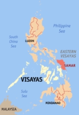
Samar Island
Overview
Island
An island or isle is any piece of sub-continental land that is surrounded by water. Very small islands such as emergent land features on atolls can be called islets, cays or keys. An island in a river or lake may be called an eyot , or holm...
in the Visayas
Visayas
The Visayas or Visayan Islands and locally known as Kabisay-an gid, is one of the three principal geographical divisions of the Philippines, along with Mindanao and Luzon. It consists of several islands, primarily surrounding the Visayan Sea, although the Visayas are considered the northeast...
, within the central Philippines
Philippines
The Philippines , officially known as the Republic of the Philippines , is a country in Southeast Asia in the western Pacific Ocean. To its north across the Luzon Strait lies Taiwan. West across the South China Sea sits Vietnam...
. The island is divided into three provinces
Provinces of the Philippines
The Provinces of the Philippines are the primary political and administrative divisions of the Philippines. There are 80 provinces at present, further subdivided into component cities and municipalities. The National Capital Region, as well as independent cities, are autonomous from any provincial...
: Samar province, Northern Samar
Northern Samar
Northern Samar is a province of the Philippines located in the Eastern Visayas region. Its capital is Catarman and is located at the northern portion of the island of Samar. Bordering the province to the south are the provinces of Samar and Eastern Samar...
, and Eastern Samar
Eastern Samar
Eastern Samar is a province of the Philippines located in the Eastern Visayas region. Its capital is the city of Borongan.-Location:...
. These three provinces, along with the provinces on the nearby islands of Leyte and Biliran
Biliran
In 1945 liberated by the Philippine Commonwealth forces of the 9th Infantry Division of the Philippine Commonwealth Army was landed in Biliran with the local guerrilla forces by the attack of the Japanese troops from the island during the Battle of Biliran during World War II.-Conversion:On April...
are part of the Eastern Visayas
Eastern Visayas
Eastern Visayas is one of the two regions of the Philippines having no land border with another region, MIMAROPA being the other, and is designated as Region VIII...
region. It is the fourth largest island in the Philippines, after Luzon
Luzon
Luzon is the largest island in the Philippines. It is located in the northernmost region of the archipelago, and is also the name for one of the three primary island groups in the country centered on the Island of Luzon...
, Mindanao
Mindanao
Mindanao is the second largest and easternmost island in the Philippines. It is also the name of one of the three island groups in the country, which consists of the island of Mindanao and smaller surrounding islands. The other two are Luzon and the Visayas. The island of Mindanao is called The...
and Negros
Negros
Negros is an island of the Philippines located in the Visayas, at . It is the third largest island in the country, with a land area of 13,328 km²...
.
Samar is the easternmost island in the Visayas. The island is separated from Leyte by the San Juanico Strait
San Juanico Strait
San Juanico Strait is a narrow strait in the Philippines. It separates the islands of Samar and Leyte. At its narrowest point, the strait is only wide, said to be the narrowest strait in the world. It is crossed by the San Juanico Bridge....
, which at its narrowest point is only about two kilometers across.
Discussions