

Theory of Portuguese discovery of Australia
Encyclopedia
European exploration of Australia
The European exploration of Australia encompasses several waves of seafarers and land explorers. Although Australia is often loosely said to have been discovered by Royal Navy Lieutenant James Cook in 1770, he was merely one of a number of European explorers to have sighted and landed on the...
began in 1606 with the voyage of the Dutch
Dutch Republic
The Dutch Republic — officially known as the Republic of the Seven United Netherlands , the Republic of the United Netherlands, or the Republic of the Seven United Provinces — was a republic in Europe existing from 1581 to 1795, preceding the Batavian Republic and ultimately...
navigator Willem Janszoon
Willem Janszoon
Willem Janszoon , Dutch navigator and colonial governor, is probably the first European known to have seen the coast of Australia. His name is sometimes abbreviated to Willem Jansz....
on board the Duyfken
Duyfken
Duyfken was a small Dutch ship built in the Netherlands. She was a fast, lightly armed ship probably intended for shallow water, small valuable cargoes, bringing messages, sending provisions, or privateering...
, a theory exists that a Portuguese
Portugal
Portugal , officially the Portuguese Republic is a country situated in southwestern Europe on the Iberian Peninsula. Portugal is the westernmost country of Europe, and is bordered by the Atlantic Ocean to the West and South and by Spain to the North and East. The Atlantic archipelagos of the...
expedition arrived in Australia
Australia
Australia , officially the Commonwealth of Australia, is a country in the Southern Hemisphere comprising the mainland of the Australian continent, the island of Tasmania, and numerous smaller islands in the Indian and Pacific Oceans. It is the world's sixth-largest country by total area...
between 1521 and 1524. The theory rests on several
tenets.
These are:
- The existence of a large landmass called Jave la GrandeJave la GrandeLa grande isle de Java was, according to Marco Polo, the largest island in the world: his Java Minor was the actual island of Sumatra, which takes its name from the city of Samudera situated on its northern coast....
, shown between IndonesiaIndonesiaIndonesia , officially the Republic of Indonesia , is a country in Southeast Asia and Oceania. Indonesia is an archipelago comprising approximately 13,000 islands. It has 33 provinces with over 238 million people, and is the world's fourth most populous country. Indonesia is a republic, with an...
and Antarctica on a group of FrenchFranceThe French Republic , The French Republic , The French Republic , (commonly known as France , is a unitary semi-presidential republic in Western Europe with several overseas territories and islands located on other continents and in the Indian, Pacific, and Atlantic oceans. Metropolitan France...
world maps, the Dieppe mapsDieppe mapsThe Dieppe maps are a series of world maps produced in Dieppe, France, in the 1540s, 1550s and 1560s. They are large hand-produced maps, commissioned for wealthy and royal patrons, including Henry II of France and Henry VIII of England...
, which carry FrenchFrench languageFrench is a Romance language spoken as a first language in France, the Romandy region in Switzerland, Wallonia and Brussels in Belgium, Monaco, the regions of Quebec and Acadia in Canada, and by various communities elsewhere. Second-language speakers of French are distributed throughout many parts...
, PortuguesePortuguese languagePortuguese is a Romance language that arose in the medieval Kingdom of Galicia, nowadays Galicia and Northern Portugal. The southern part of the Kingdom of Galicia became independent as the County of Portugal in 1095...
, and Gallicized Portuguese placenames and which by various means can be interpreted to look similar to Australia's northwestern and eastern coasts. - The presence of the PortuguesePortuguese EmpireThe Portuguese Empire , also known as the Portuguese Overseas Empire or the Portuguese Colonial Empire , was the first global empire in history...
in Southeast AsiaSoutheast AsiaSoutheast Asia, South-East Asia, South East Asia or Southeastern Asia is a subregion of Asia, consisting of the countries that are geographically south of China, east of India, west of New Guinea and north of Australia. The region lies on the intersection of geological plates, with heavy seismic...
from the early 16th century, especially their exploration and later colonization of TimorTimorTimor is an island at the southern end of Maritime Southeast Asia, north of the Timor Sea. It is divided between the independent state of East Timor, and West Timor, belonging to the Indonesian province of East Nusa Tenggara. The island's surface is 30,777 square kilometres...
- less than 500 kilometres from the Australian coast - circa 1513-1516. - Various antiquities and unsolved mysteries found on Australian and New ZealandNew ZealandNew Zealand is an island country in the south-western Pacific Ocean comprising two main landmasses and numerous smaller islands. The country is situated some east of Australia across the Tasman Sea, and roughly south of the Pacific island nations of New Caledonia, Fiji, and Tonga...
's coastlines, that may relate to early Portuguese voyages to Australia.
Precedence of discovery has also been claimed for China
China
Chinese civilization may refer to:* China for more general discussion of the country.* Chinese culture* Greater China, the transnational community of ethnic Chinese.* History of China* Sinosphere, the area historically affected by Chinese culture...
,, France
France
The French Republic , The French Republic , The French Republic , (commonly known as France , is a unitary semi-presidential republic in Western Europe with several overseas territories and islands located on other continents and in the Indian, Pacific, and Atlantic oceans. Metropolitan France...
, Spain
Spain
Spain , officially the Kingdom of Spain languages]] under the European Charter for Regional or Minority Languages. In each of these, Spain's official name is as follows:;;;;;;), is a country and member state of the European Union located in southwestern Europe on the Iberian Peninsula...
and even Phoenicia
Phoenicia
Phoenicia , was an ancient civilization in Canaan which covered most of the western, coastal part of the Fertile Crescent. Several major Phoenician cities were built on the coastline of the Mediterranean. It was an enterprising maritime trading culture that spread across the Mediterranean from 1550...
.
Development of the theory in the 19th Century
Although Alexander DalrympleAlexander Dalrymple
Alexander Dalrymple was a Scottish geographer and the first Hydrographer of the British Admiralty. He was the main proponent of the theory that there existed a vast undiscovered continent in the South Pacific, Terra Australis Incognita...
wrote on this topic in 1786, it was R. H. Major
Richard Henry Major
Richard Henry Major was a geographer and map librarian who curated the map collection of the British Museum from 1844 until his retirement in 1880. During that time he published a number of books related to maps or documents of historical significance...
, Keeper of Maps at the British Museum
British Museum
The British Museum is a museum of human history and culture in London. Its collections, which number more than seven million objects, are amongst the largest and most comprehensive in the world and originate from all continents, illustrating and documenting the story of human culture from its...
who first made significant efforts to prove the Portuguese
Portugal
Portugal , officially the Portuguese Republic is a country situated in southwestern Europe on the Iberian Peninsula. Portugal is the westernmost country of Europe, and is bordered by the Atlantic Ocean to the West and South and by Spain to the North and East. The Atlantic archipelagos of the...
discovered Australia before the Dutch
Dutch language
Dutch is a West Germanic language and the native language of the majority of the population of the Netherlands, Belgium, and Suriname, the three member states of the Dutch Language Union. Most speakers live in the European Union, where it is a first language for about 23 million and a second...
, in 1859. A group of mid sixteenth century French maps, the Dieppe maps, formed his main evidence. Today there is widespread agreement that his approach to historical research was flawed and his claims often exaggerated. Writing in an academic journal in 1861, Major announced the discovery of a map by Manuel Godinho de Eredia, claiming it proved a Portuguese discovery of North Western Australia, possibly dated to 1601. In fact, as W.A.R. Richardson points out, this map's origins are from 1630. On finally locating and examining Erédia’s writings, Major realised the planned voyage to lands south of Sumba
Sumba
Sumba is an island in eastern Indonesia, is one of the Lesser Sunda Islands, and is in the province of East Nusa Tenggara. Sumba has an area of 11,153 km², and the population was officially at 611,422 in 2005...
in Indonesia had never taken place. Major published a retraction in 1873, but his reputation was destroyed.
In 1895, George Collingridge
George Collingridge
George Collingridge was an Australian writer and illustrator best known today for his early assertions of Portuguese discovery of Australia in the 16th century....
produced his The Discovery of Australia, an attempt to trace all European efforts to find the Great Southern Land to the time of Cook
James Cook
Captain James Cook, FRS, RN was a British explorer, navigator and cartographer who ultimately rose to the rank of captain in the Royal Navy...
, and also introducing his interpretation of the theory of Portuguese discovery of Australia, using the Dieppe maps. Fluent in Portuguese
Portuguese language
Portuguese is a Romance language that arose in the medieval Kingdom of Galicia, nowadays Galicia and Northern Portugal. The southern part of the Kingdom of Galicia became independent as the County of Portugal in 1095...
and Spanish
Spanish language
Spanish , also known as Castilian , is a Romance language in the Ibero-Romance group that evolved from several languages and dialects in central-northern Iberia around the 9th century and gradually spread with the expansion of the Kingdom of Castile into central and southern Iberia during the...
, Collingridge
George Collingridge
George Collingridge was an Australian writer and illustrator best known today for his early assertions of Portuguese discovery of Australia in the 16th century....
was inspired by the publicity surrounding the arrival in Australia of copies of several Dieppe maps, which had been purchased by libraries in Melbourne
Melbourne
Melbourne is the capital and most populous city in the state of Victoria, and the second most populous city in Australia. The Melbourne City Centre is the hub of the greater metropolitan area and the Census statistical division—of which "Melbourne" is the common name. As of June 2009, the greater...
, Adelaide
Adelaide
Adelaide is the capital city of South Australia and the fifth-largest city in Australia. Adelaide has an estimated population of more than 1.2 million...
and Sydney
Sydney
Sydney is the most populous city in Australia and the state capital of New South Wales. Sydney is located on Australia's south-east coast of the Tasman Sea. As of June 2010, the greater metropolitan area had an approximate population of 4.6 million people...
. Despite a number of errors regarding placenames, and “untenable” theories to explain misplacement on the Dieppe maps, his book was a remarkable effort considering it was written at a time when many maps and documents were inaccessible and document photography was still in its infancy. Collingridge's theory did not find public approval however and Professors G. Arnold Wood and Ernest Scott publicly criticised much of what he had written. Collingridge produced a shorter version of this book for use in New South Wales schools; The First Discovery of Australia and New Guinea. It was not used.
Professor Edward Heawood also provided early criticism of the theory. In 1899 he noted that the argument for the coasts of Australia having been reached early in the sixteenth century rested almost entirely on the supposition that at that time, “a certain unknown map-maker drew a large land, with indications of definite knowledge of its coasts, in the quarter of the globe in which Australia is placed”. He pointed out that “a difficulty arises from the necessity of supposing at least two separate voyages of discovery, one on each coast, though absolutely no record of any such exists”. He added; “ The difficulty, of course, has been to account for this map in any other way”. The delineation of Japan
Japan
Japan is an island nation in East Asia. Located in the Pacific Ocean, it lies to the east of the Sea of Japan, China, North Korea, South Korea and Russia, stretching from the Sea of Okhotsk in the north to the East China Sea and Taiwan in the south...
in the Dieppe maps, the insertion in them of an Isle des Géants in the southern Indian Ocean
Indian Ocean
The Indian Ocean is the third largest of the world's oceanic divisions, covering approximately 20% of the water on the Earth's surface. It is bounded on the north by the Indian Subcontinent and Arabian Peninsula ; on the west by eastern Africa; on the east by Indochina, the Sunda Islands, and...
, and of Catigara on the west coast of South America
South America
South America is a continent situated in the Western Hemisphere, mostly in the Southern Hemisphere, with a relatively small portion in the Northern Hemisphere. The continent is also considered a subcontinent of the Americas. It is bordered on the west by the Pacific Ocean and on the north and east...
, and in their later versions the depiction of a fictitious coast-line of a southern continent with numerous bays and rivers, showed the slight reliance to be placed on them with respect to outlying parts of the world and the influence still exercised on their makers by the old writers. He concluded: “This should surely make us hesitate to base so important assumption as that of a discovery of Australia in the sixteenth century on their unsupported testimony”.
Kenneth McIntyre and development of the theory in the 20th Century
The development of the theory of Portuguese discovery of Australia owes much to MelbourneMelbourne
Melbourne is the capital and most populous city in the state of Victoria, and the second most populous city in Australia. The Melbourne City Centre is the hub of the greater metropolitan area and the Census statistical division—of which "Melbourne" is the common name. As of June 2009, the greater...
lawyer Kenneth McIntyre
Kenneth McIntyre
Kenneth Gordon McIntyre OBE was an Australian lawyer, historian and mathematician who is perhaps best known for his controversial book The Secret Discovery of Australia - Portuguese ventures 200 years before Captain Cook....
's 1977 book, The Secret Discovery of Australia; Portuguese ventures 200 years before Cook. McIntyre's book was reprinted in an abridged paperback edition in 1982 and again in 1987 and it was found on school history reading lists by the mid 1980s. According to Dr. Tony Disney, McIntyre's theory influenced a generation of History teachers in Australian schools. A TV documentary was made of the book in the 1980s by Michael Thornhill
Michael Thornhill
Michael Thornhill is a film producer, screenwriter, and director.He has a background in freelance journalism and publishing including working as a film critic....
and McIntyre and the theory featured in many positive newspaper reviews and articles over the next twenty years. Australian History school textbooks also reflect the evolution of acceptance of his theories. The support of Dr. Helen Wallis, Curator of Maps at the British Library
British Library
The British Library is the national library of the United Kingdom, and is the world's largest library in terms of total number of items. The library is a major research library, holding over 150 million items from every country in the world, in virtually all known languages and in many formats,...
during her visits to Australia in the 1980s seemed to add academic weight to McIntyre's theory. In 1987, the Australian Minister for Science, Barry Jones
Barry Jones (Australian politician)
Barry Owen Jones AO, FAA, FASSA, FAHA, FTSE, FACE is a writer, lawyer, social activist, quiz champion and former politician. He campaigned against the death penalty throughout the 1960s, particularly against the execution of Ronald Ryan, and remains against capital punishment...
, launching the Second Mahogany Ship
Mahogany Ship
The Mahogany Ship refers to a putative, early shipwreck that is purported to lie beneath the sand in the Armstrong Bay area, approximately 3 to 6 kilometres west of Warrnambool in southwest Victoria, Australia...
Symposium in Warrnambool, said "I read Kenneth McIntyre's important book... as soon as it appeared in 1977. I found its central argument... persuasive, if not conclusive." The appearance of variant but essentially supporting theories in the late 1970s and early 1980s by other writers, including Ian McKiggan and Lawrence Fitzgerald also added credence to the theory of Portuguese discovery of Australia.
In 1994, McIntyre expressed pleasure that his theory was gaining acceptance in Australia.
In the 1970s and 1980s, German born linguist Dr. Carl-Georg von Brandenstein, approaching the theory from another perspective, claimed he had found 60 words used by Aboriginal people of the Australian north-west that had Portuguese origins. He went further, claiming the Portuguese had created a “secret colony...and cut a road as far as the present day town of Broome
Broome, Western Australia
Broome is a pearling and tourist town in the Kimberley region of Western Australia, north of Perth. The year round population is approximately 14,436, growing to more than 45,000 per month during the tourist season...
” and that "stone housing in the east Kimberley could not have been made without outside influence." However, as Dr. Nick Thieberger has noted, modern linguisitic and archaeological research has not corroborated his arguments.
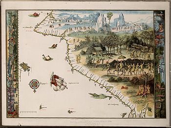
Interpretation of the Dieppe Maps
The central plank of the theory of Portuguese discovery of Australia suggests the continent called Jave la GrandeJave la Grande
La grande isle de Java was, according to Marco Polo, the largest island in the world: his Java Minor was the actual island of Sumatra, which takes its name from the city of Samudera situated on its northern coast....
, that uniquely appears on a series of 16th century French world maps, the Dieppe school of maps
Dieppe maps
The Dieppe maps are a series of world maps produced in Dieppe, France, in the 1540s, 1550s and 1560s. They are large hand-produced maps, commissioned for wealthy and royal patrons, including Henry II of France and Henry VIII of England...
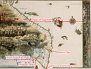
, represents Australia. Speaking in 1982, Kenneth McIntyre described the Dieppe maps as "the only evidence of Portuguese discovery of Eastern Australia". He stressed this to point out "that the Mahogany Ship
Mahogany Ship
The Mahogany Ship refers to a putative, early shipwreck that is purported to lie beneath the sand in the Armstrong Bay area, approximately 3 to 6 kilometres west of Warrnambool in southwest Victoria, Australia...
, and the Geelong Keys
Geelong Keys
The Geelong Keys were a set of keys discovered in 1845 or 1846 in the time of Governor Charles La Trobe at Corio Bay in Victoria, Australia. They were embedded in the stone of the beach in such a way as to make him believe that they had been there for 100–150 years...
, and other things of that sort, are not part of the proof that the Portuguese discovered Australia. It is the other way around. The Dieppe maps prove (sic) that the Portuguese discovered Australia, and this throws a fierce bright light on our mysteries such as the Mahogany Ship
Mahogany Ship
The Mahogany Ship refers to a putative, early shipwreck that is purported to lie beneath the sand in the Armstrong Bay area, approximately 3 to 6 kilometres west of Warrnambool in southwest Victoria, Australia...
" Later writers on the same topic take the same approach of concentrating primaily on "Jave La Grande" as it appears in the Dieppe maps, including Fitzgerald, McKiggan and most recently, Peter Trickett.
Critics of the theory of Portuguese Discovery of Australia, including A. Ariel, M. Pearson and W.A.R. Richardson, also concentrate on the "Jave la Grande" landmass of the Dieppe maps.
Jave la Grande
Jave la Grande
La grande isle de Java was, according to Marco Polo, the largest island in the world: his Java Minor was the actual island of Sumatra, which takes its name from the city of Samudera situated on its northern coast....
as it appears on the Dieppe world maps is widely agreed to be at least partly based on Portuguese sources that no longer exist. McIntyre attributed discrepancies between the Jave la Grande coastline and Australia's to the difficulties of accurately recording positions without a reliable method of determining longitude
Longitude
Longitude is a geographic coordinate that specifies the east-west position of a point on the Earth's surface. It is an angular measurement, usually expressed in degrees, minutes and seconds, and denoted by the Greek letter lambda ....
, and the techniques used to convert maps to different projections.
In the late 1970s, mathematician Ian McKiggan developed his theory of exponential longitude error theory to explain discrepancies, although he modified this position after a public exchange of opinion with W.A.R. Richardson. McIntyre's own theory about distortion of the maps and the calculations used to correct the maps has also been challenged. Both Lawrence Fitzgerald and Peter Trickett argue Jave la Grande is based on Portuguese sea charts, now lost, which the mapmakers of Dieppe misaligned. Both these writers try to compare the coastal features of Jave La Grande with modern Australia's, by realigning them.
In 1994, McIntyre suggested that the writings of Pedro Nunes
Pedro Nunes
Pedro Nunes , was a Portuguese mathematician, cosmographer, and professor, from a New Christian family. Nunes, considered to be one of the greatest mathematicians of his time , is best known for his contributions in the technical field of navigation, which was crucial to the Portuguese period of...
supported his interpretation of the distortion that occurred on the Dieppe Maps.
Helen Wallis
Helen Wallis
Helen Margaret Wallis was the Map Curator of the British Library from 1967 to 1987.-Biography:Born in Barnet, Wallis attended St Paul's School for Girls and studied at St Hugh's College, Oxford, where she completed her D.Phil degree in 1954.In 1951, she was appointed assistant to R.A...
, Keeper of Maps at the British Museum
British Museum
The British Museum is a museum of human history and culture in London. Its collections, which number more than seven million objects, are amongst the largest and most comprehensive in the world and originate from all continents, illustrating and documenting the story of human culture from its...
, referred in 1988 to the interpretation “explosion” on the subject of the Dieppe maps. She herself argued the case for discovery of Australia by “a local Portuguese voyage otherwise unknown” seventy years before the Dutch
Netherlands
The Netherlands is a constituent country of the Kingdom of the Netherlands, located mainly in North-West Europe and with several islands in the Caribbean. Mainland Netherlands borders the North Sea to the north and west, Belgium to the south, and Germany to the east, and shares maritime borders...
, a chart of which was “presumably” brought back to Dieppe by the survivors of a French
France
The French Republic , The French Republic , The French Republic , (commonly known as France , is a unitary semi-presidential republic in Western Europe with several overseas territories and islands located on other continents and in the Indian, Pacific, and Atlantic oceans. Metropolitan France...
voyage to Sumatra
Sumatra
Sumatra is an island in western Indonesia, westernmost of the Sunda Islands. It is the largest island entirely in Indonesia , and the sixth largest island in the world at 473,481 km2 with a population of 50,365,538...
led by Jean Parmentier
Jean Parmentier
Jean Parmentier , born in Dieppe, France, was a navigator, cartographer, and poet. Jean and his brother Raoul made numerous voyages for the shipowner Jean Ango, and sailed to the coasts of Brazil, North America, West Africa and Sumatra....
in 1529-30.
In the most recent interpretation of the Dieppe maps, Professor Gayle K. Brunelle of California State University
California State University
The California State University is a public university system in the state of California. It is one of three public higher education systems in the state, the other two being the University of California system and the California Community College system. It is incorporated as The Trustees of the...
argued that the Dieppe school of cartographers should be seen as acting as propagandists for French geographic knowledge and territorial claims. The decades from about 1535 to 1562 when the Dieppe school of cartographers flourished were also the period in which French trade with the New World was at its sixteenth century height, in terms of the North Atlantic fish trade, the fur trade, and, most important for the cartographers, the rivalry with the Portuguese for control of the coasts of Brazil and the supplies of lucrative brazilwood. The bright red dye produced from brazilwood replaced woad as the primary dyestuff in the cloth industry in France and the Low Countries. The Dieppe cartographers used the skills and geographic knowledge of Portuguese mariners, pilots and geographers working in France to produce maps meant to emphasize French interests in and dominion over territory in the New World that the Portuguese also claimed, both in Newfoundland and in Brazil. Brunelle noted that, in design and decorative style the Dieppe maps represented a blending of the latest knowledge circulating in Europe with older visions of world geography deriving from Ptolemy and mediaeval cartographers and explorers such as Marco Polo. Renaissance mapmakers such as those based in Dieppe relied heavily on each other’s work, as well as on maps from previous generations, and thus their maps represented a mixture of old and new information often coexisting uneasily in the same map
Cristóvão de Mendonça's role
Cristóvão de Mendonça
Cristóvão de Mendonça was a Portuguese sailor and statesman who was active in South East Asia in the 16th century.-Mendonça in João de Barros's Décadas da Ásia:...
is known from a small number of Portuguese sources, notably the famous Portuguese historian João de Barros
João de Barros
João de Barros , called the Portuguese Livy, is one of the first great Portuguese historians, most famous for his Décadas da Ásia , a history of the Portuguese in India and Asia.-Early years:...
in Décadas da Ásia (Decades of Asia), a history of the growth of the Portuguese Empire
Portuguese Empire
The Portuguese Empire , also known as the Portuguese Overseas Empire or the Portuguese Colonial Empire , was the first global empire in history...
in India and Asia, published between 1552-1615. Mendonça appears in Barros' account with instructions to search for Magellan
Ferdinand Magellan
Ferdinand Magellan was a Portuguese explorer. He was born in Sabrosa, in northern Portugal, and served King Charles I of Spain in search of a westward route to the "Spice Islands" ....
, and later Marco Polo
Marco Polo
Marco Polo was a Venetian merchant traveler from the Venetian Republic whose travels are recorded in Il Milione, a book which did much to introduce Europeans to Central Asia and China. He learned about trading whilst his father and uncle, Niccolò and Maffeo, travelled through Asia and apparently...
's legendary Isles of Gold. However, Mendonça and other Portuguese sailors are then described as assisting with the construction of a fort at Pedir (Sumatra
Sumatra
Sumatra is an island in western Indonesia, westernmost of the Sunda Islands. It is the largest island entirely in Indonesia , and the sixth largest island in the world at 473,481 km2 with a population of 50,365,538...
) and Barros does not mention the expedition again.
McIntyre nominated Cristóvão de Mendonça as the commander of a voyage to Australia c.1521-1524, one he argued had to be kept secret because of the 1494 Treaty of Tordesillas
Treaty of Tordesillas
The Treaty of Tordesillas , signed at Tordesillas , , divided the newly discovered lands outside Europe between Spain and Portugal along a meridian 370 leagueswest of the Cape Verde islands...
, which divided the undiscovered world into two halves for Portugal
Portugal
Portugal , officially the Portuguese Republic is a country situated in southwestern Europe on the Iberian Peninsula. Portugal is the westernmost country of Europe, and is bordered by the Atlantic Ocean to the West and South and by Spain to the North and East. The Atlantic archipelagos of the...
and Spain
Spain
Spain , officially the Kingdom of Spain languages]] under the European Charter for Regional or Minority Languages. In each of these, Spain's official name is as follows:;;;;;;), is a country and member state of the European Union located in southwestern Europe on the Iberian Peninsula...
. Barros and other Portuguese sources do not mention a discovery of land that could be Australia, but McIntyre conjectured this was because original documents were lost in the 1755 Lisbon earthquake
1755 Lisbon earthquake
The 1755 Lisbon earthquake, also known as the Great Lisbon Earthquake, was a megathrust earthquake that took place on Saturday 1 November 1755, at around 9:40 in the morning. The earthquake was followed by fires and a tsunami, which almost totally destroyed Lisbon in the Kingdom of Portugal, and...
, or the official policy of silence.
Most proponents of the theory of Portuguese discovery of Australia have supported McIntyre's hypothesis that it was Mendonça who sailed down the eastern Australian coast and provided charts which found their way onto the Dieppe maps, to be included as "Jave la Grande" in the 1540, 1550s and 1560s. McIntyre claimed the maps indicated Mendonça went as far south as Port Fairy, Victoria
Victoria (Australia)
Victoria is the second most populous state in Australia. Geographically the smallest mainland state, Victoria is bordered by New South Wales, South Australia, and Tasmania on Boundary Islet to the north, west and south respectively....
; Fitzgerald claims they show he went as far as Tasmania
Tasmania
Tasmania is an Australian island and state. It is south of the continent, separated by Bass Strait. The state includes the island of Tasmania—the 26th largest island in the world—and the surrounding islands. The state has a population of 507,626 , of whom almost half reside in the greater Hobart...
; Trickett states as far as Spencer Gulf
Spencer Gulf
The Spencer Gulf is the westernmost of two large inlets on the southern coast of Australia, in the state of South Australia, facing the Great Australian Bight. The Gulf is 322 km long and 129 km wide at its mouth. The western shore of the Gulf is the Eyre Peninsula, while the eastern side is the...
in South Australia
South Australia
South Australia is a state of Australia in the southern central part of the country. It covers some of the most arid parts of the continent; with a total land area of , it is the fourth largest of Australia's six states and two territories.South Australia shares borders with all of the mainland...
, and New Zealand's North Island
North Island
The North Island is one of the two main islands of New Zealand, separated from the much less populous South Island by Cook Strait. The island is in area, making it the world's 14th-largest island...
.
Alternative views
In the last chapter of The Secret Discovery of Australia, Kenneth McIntyre threw down a challenge, saying: “Every critic who seeks to deny the Portuguese discovery of Australia is faced with the problem of providing an alternative theory to explain away the existence of the Dieppe maps. If the Dauphin is not the record of real exploration, then what is it?”Possibly because of the degree of conjecture involved in the theory of Portuguese discovery of Australia, there have been a number of critics. By far the most prolific writer on this theory, and also its most consistent critic, has been Flinders University
Flinders University
Flinders University, , is a public university in Adelaide, South Australia. Founded in 1966, it was named in honour of navigator Matthew Flinders, who explored and surveyed the South Australian coastline in the early 19th century.The university has established a reputation as a leading research...
Associate Professor W.A.R (Bill) Richardson, who has written 20 articles relating to the topic since 1983. As Richardson, an academic fluent in Portuguese
Portuguese language
Portuguese is a Romance language that arose in the medieval Kingdom of Galicia, nowadays Galicia and Northern Portugal. The southern part of the Kingdom of Galicia became independent as the County of Portugal in 1095...
and Spanish
Spanish language
Spanish , also known as Castilian , is a Romance language in the Ibero-Romance group that evolved from several languages and dialects in central-northern Iberia around the 9th century and gradually spread with the expansion of the Kingdom of Castile into central and southern Iberia during the...
, first approached the Dieppe maps in an effort to prove they did relate to Portuguese discovery of Australia, his criticisms are all the more interesting. He suggests he quickly realised there was no connection between the Dieppe maps and modern Australia's coastline.
He dismisses the claim that Cristóvão de Mendonça
Cristóvão de Mendonça
Cristóvão de Mendonça was a Portuguese sailor and statesman who was active in South East Asia in the 16th century.-Mendonça in João de Barros's Décadas da Ásia:...
sailed down the east coast of Australia as sheer speculation, based on voyages about which no details have survived. In the same way, the re-assembling of sections of the "Jave La Grande" coastline so that it fits the straightjacket of the real outline of Australia relies upon a second set of assumptions. He argues taking that approach, "Jave La Grande" could be re-assembled to look like anything.
Another dimension of the argument Richardson advances against the theory relates to methodology. Richardson argues McIntyre's practice of re-drawing sections of maps in his book was misleading because in an effort to clarify he actually omitted crucial features and names that did not support the Portuguese discovery theory.
Richardson's own view is that a study of placenames (toponymy
Toponymy
Toponymy is the scientific study of place names , their origins, meanings, use and typology. The word "toponymy" is derived from the Greek words tópos and ónoma . Toponymy is itself a branch of onomastics, the study of names of all kinds...
) on "Jave La Grande" identifies it as unmistakably connected to the coasts of southern Java
Java
Java is an island of Indonesia. With a population of 135 million , it is the world's most populous island, and one of the most densely populated regions in the world. It is home to 60% of Indonesia's population. The Indonesian capital city, Jakarta, is in west Java...
and Indochina
Indochina
The Indochinese peninsula, is a region in Southeast Asia. It lies roughly southwest of China, and east of India. The name has its origins in the French, Indochine, as a combination of the names of "China" and "India", and was adopted when French colonizers in Vietnam began expanding their territory...
. Emeritus Professor Victor Prescott has claimed Richardson “brilliantly demolished the argument that Java la Grande show(s) the east coast of Australia.” However, Australian historian Alan Frost has recently written that Richardson’s argument is “so speculative and convoluted as not to be credible”.
In 1984, criticism of The Secret Discovery of Australia also came from master mariner Captain A. Ariel, who argued McIntyre had made serious errors in his explanation and measurement of "erration" in longitude. Ariel concluded that McIntyre erred on “all navigational...counts” and that The Secret Discovery of Australia was a “monumental piece of misinterpretation.”
In 2005, Historian Michael Pearson made the following comment on the Dieppe maps as evidence of a Portuguese discovery of Australia;
Robert J. King has recently argued that Jave la Grande on the Dieppe maps is a theoretical construction, reflecting 16th century views of cosmography. In an article written in 2009, he pointed out that the geographers and map makers of the Renaissance struggled to bridge the gap from the world-view inherited from Graeco-Roman antiquity, as set out in Claudius Ptolemy’s Geography, and a map of the world that would take account of the new geographical information obtained during the Age of Discoveries. The Dieppe world maps reflected the state of geographical knowledge of their time, both actual and theoretical. Accordingly, Java Major, or Jave la Grande, was shown as a promontory of the undiscovered antarctic continent of Terra Australis
Terra Australis
Terra Australis, Terra Australis Ignota or Terra Australis Incognita was a hypothesized continent appearing on European maps from the 15th to the 18th century...
. This reflected a misunderstanding of where Marco Polo had located Java Minor and confusion regarding the relative positions of parts of East and Southeast Asia and America. In an argument similar to Professor Gayle K. Brunelle's, King suggests that Jave la Grande on the Dieppe maps represents one of Marco Polo’s pair of Javas (Major or Minor), misplaced far to the south of its actual location and attached to a greatly enlarged Terra Australis
Terra Australis
Terra Australis, Terra Australis Ignota or Terra Australis Incognita was a hypothesized continent appearing on European maps from the 15th to the 18th century...
. He believes it does not represent Australia discovered by unknown Portuguese voyagers.
Mahogany Ship
According to McIntyre, the remains of one of Cristóvão de MendonçaCristóvão de Mendonça
Cristóvão de Mendonça was a Portuguese sailor and statesman who was active in South East Asia in the 16th century.-Mendonça in João de Barros's Décadas da Ásia:...
's caravels was discovered in 1836 by a group of shipwrecked whalers while walking along the sand dunes to the nearest settlement, Port Fairy
Port Fairy, Victoria
Port Fairy is a coastal town in south-western Victoria, Australia. It lies on the Princes Highway in the Shire of Moyne, west of Warrnambool and 290 km west of Melbourne, at the point where the Moyne River enters the Southern Ocean.-History:...
. The men came across the wreck of a ship made of wood that appeared to be mahogany
Mahogany
The name mahogany is used when referring to numerous varieties of dark-colored hardwood. It is a native American word originally used for the wood of the species Swietenia mahagoni, known as West Indian or Cuban mahogany....
. Between 1836 and 1880, 40 different people recorded that they had seen an "ancient" or "Spanish" wreck. Whatever it was, the wreck has not been seen since 1880 despite extensive searches in recent times. McIntyre's accuracy in transcribing original documents to support his argument has been criticized by some recent writers.
Other textual and cartographic evidence
New Guinea
New Guinea is the world's second largest island, after Greenland, covering a land area of 786,000 km2. Located in the southwest Pacific Ocean, it lies geographically to the east of the Malay Archipelago, with which it is sometimes included as part of a greater Indo-Australian Archipelago...
with a variety of flora and fauna. Part of one of Cornelis De Jode's 1593 maps depicts New Guinea
New Guinea
New Guinea is the world's second largest island, after Greenland, covering a land area of 786,000 km2. Located in the southwest Pacific Ocean, it lies geographically to the east of the Malay Archipelago, with which it is sometimes included as part of a greater Indo-Australian Archipelago...
with a hypothetical land to the south inhabited by dragon
Dragon
A dragon is a legendary creature, typically with serpentine or reptilian traits, that feature in the myths of many cultures. There are two distinct cultural traditions of dragons: the European dragon, derived from European folk traditions and ultimately related to Greek and Middle Eastern...
s. Kenneth McIntyre suggested that although Cornelis de Jode was Dutch
Dutch people
The Dutch people are an ethnic group native to the Netherlands. They share a common culture and speak the Dutch language. Dutch people and their descendants are found in migrant communities worldwide, notably in Suriname, Chile, Brazil, Canada, Australia, South Africa, New Zealand, and the United...
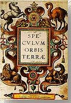
the title page of his "Speculum Orbis Terrae
Speculum Orbis Terrae
Speculum Orbis Terrae , was an atlas published by Cornelis de Jode in Antwerp 1593. The atlas was largely a continuation of his father's unfinished works at his death in 1591. Contemporary scholars consider many of de Jode's maps to be superior both in detail and style to those of the competing...
" 1593 atlas may provide evidence of early Portuguese knowledge of Australia. The page depicts four animals. There is a horse to represent Europe, a camel
Camel
A camel is an even-toed ungulate within the genus Camelus, bearing distinctive fatty deposits known as humps on its back. There are two species of camels: the dromedary or Arabian camel has a single hump, and the bactrian has two humps. Dromedaries are native to the dry desert areas of West Asia,...
to represent Asia
Asia
Asia is the world's largest and most populous continent, located primarily in the eastern and northern hemispheres. It covers 8.7% of the Earth's total surface area and with approximately 3.879 billion people, it hosts 60% of the world's current human population...
, a lion
Lion
The lion is one of the four big cats in the genus Panthera, and a member of the family Felidae. With some males exceeding 250 kg in weight, it is the second-largest living cat after the tiger...
for Africa
Africa
Africa is the world's second largest and second most populous continent, after Asia. At about 30.2 million km² including adjacent islands, it covers 6% of the Earth's total surface area and 20.4% of the total land area...
, and another animal that resembles a kangaroo
Kangaroo
A kangaroo is a marsupial from the family Macropodidae . In common use the term is used to describe the largest species from this family, especially those of the genus Macropus, Red Kangaroo, Antilopine Kangaroo, Eastern Grey Kangaroo and Western Grey Kangaroo. Kangaroos are endemic to the country...
to represent another continent. This creature features a marsupial
Marsupial
Marsupials are an infraclass of mammals, characterized by giving birth to relatively undeveloped young. Close to 70% of the 334 extant species occur in Australia, New Guinea, and nearby islands, with the remaining 100 found in the Americas, primarily in South America, but with thirteen in Central...
pouch containing two offspring and the characteristically bent hind legs of a kangaroo or one of the family of macropods. However, as members of the Macropod family are found in New Guinea and the Bismarck Archipelago
Bismarck Archipelago
The Bismarck Archipelago is a group of islands off the northeastern coast of New Guinea in the western Pacific Ocean and is part of the Islands Region of Papua New Guinea.-History:...
(including the Dusky Pademelon, Agile Wallaby and Black Dorcopsis Wallaby) this may have no relevance to a possible Portuguese discovery of Australia. Another explanation is that the animal may be based on a North America
North America
North America is a continent wholly within the Northern Hemisphere and almost wholly within the Western Hemisphere. It is also considered a northern subcontinent of the Americas...
n Opossum
Didelphimorphia
Opossums make up the largest order of marsupials in the Western Hemisphere, including 103 or more species in 19 genera. They are also commonly called possums, though that term technically refers to Australian fauna of the suborder Phalangeriformes. The Virginia opossum was the first animal to be...
.
The Geelong Keys
In 1847, at Limeburners Point near Geelong, VictoriaVictoria (Australia)
Victoria is the second most populous state in Australia. Geographically the smallest mainland state, Victoria is bordered by New South Wales, South Australia, and Tasmania on Boundary Islet to the north, west and south respectively....
, Charles La Trobe
Charles La Trobe
Charles Joseph La Trobe was the first lieutenant-governor of the colony of Victoria .-Early life:La Trobe was born in London, the son of Christian Ignatius Latrobe, a family of Huguenot origin...
, a keen amateur geologist, was examining the shells from a lime kiln when a worker showed him a set of five keys he claimed to have found. La Trobe concluded that the keys were dropped onto the beach around 100–150 years before. Kenneth McIntyre hypothesized they were dropped in 1522 by Mendonça or one of his sailors. Since the keys have been lost, however, their origin cannot be verified.
Another more likely theory is that the keys were dropped by one of the diggers shortly before being found, as the layer of dirt/shells etc. they were found below was dated as around 2300–2800 years old, making La Trobe's dating implausible. The error by La Trobe is quite understandable according to Geologists Edmund Gill and P.F.B. Alsop, given that in 1847 most people thought the world was only 6000 years old.
The Carronade Island Cannons
Two bronze cannonCannon
A cannon is any piece of artillery that uses gunpowder or other usually explosive-based propellents to launch a projectile. Cannon vary in caliber, range, mobility, rate of fire, angle of fire, and firepower; different forms of cannon combine and balance these attributes in varying degrees,...
s were found on a small island in Napier Broome Bay, on the coast of Western Australia
Western Australia
Western Australia is a state of Australia, occupying the entire western third of the Australian continent. It is bounded by the Indian Ocean to the north and west, the Great Australian Bight and Indian Ocean to the south, the Northern Territory to the north-east and South Australia to the south-east...
in 1916. Since these guns were erroneously thought to be carronades, the small island was named "Carronade Island
Carronade Island
Carronade Island lies off the northern coast of Western Australia .-References:* Green, Jeremy N. The Carronade Island guns and Australia's early visitors. Great circle, Vol.4, no.1 , p.73-83....
".
Kenneth McIntyre believed these cannons gave weight to the theory of Portuguese discovery of Australia. However, scientists at the Western Australian Museum
Western Australian Museum
The Western Australian Museum is the state museum for Western Australia.The Western Australian Museum has seven main sites: two in Perth within the Perth Cultural Centre, two in Fremantle , and one each in Albany, Geraldton, and Kalgoorlie-Boulder...
in Fremantle
Fremantle, Western Australia
Fremantle is a city in Western Australia, located at the mouth of the Swan River. Fremantle Harbour serves as the port of Perth, the state capital. Fremantle was the first area settled by the Swan River colonists in 1829...
have recently made a detailed analysis and have determined that these weapons are almost certainly of late 18th century Makassan
Makassar
Makassar, is the provincial capital of South Sulawesi, Indonesia, and the largest city on Sulawesi Island. From 1971 to 1999, the city was named Ujung Pandang, after a precolonial fort in the city, and the two names are often used interchangeably...
, rather than European, origin.
Bittangabee Bay
Bittangabee Bay
Bittangabee Bay is a tiny picturesque bay on the rugged and remote stretch of coastline south of Eden, New South Wales in New South Wales . The bay is located in Ben Boyd National Park, with a small camping ground and facilities maintained by...
were of Portuguese origin in 1977. Bittangabee Bay
Bittangabee Bay
Bittangabee Bay is a tiny picturesque bay on the rugged and remote stretch of coastline south of Eden, New South Wales in New South Wales . The bay is located in Ben Boyd National Park, with a small camping ground and facilities maintained by...
is located in Ben Boyd National Park
Ben Boyd National Park
Ben Boyd National Park is a national park in New South Wales, Australia, south of Sydney. It is named after the entrepreneur Ben Boyd who had a variety of interests in the far South Coast of New South Wales including whaling and farming. The park itself was established in 1971...
near Eden
Eden, New South Wales
Eden is a coastal town in the South Coast region of New South Wales, Australia. The town, south of the state capital Sydney near the border with Victoria, is located between Nullica Bay to the south and Calle Calle Bay, the northern reach of Twofold Bay, and built on undulating land adjacent to a...
on the south coast of New South Wales
New South Wales
New South Wales is a state of :Australia, located in the east of the country. It is bordered by Queensland, Victoria and South Australia to the north, south and west respectively. To the east, the state is bordered by the Tasman Sea, which forms part of the Pacific Ocean. New South Wales...
.
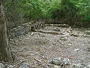
The ruins are the foundations of a building, surrounded by stone rubble that McIntyre argued may have once formed a defensive wall. McIntyre also identified the date 15?4 carved into a stone. McIntyre hypothesized the crew of a Portuguese caravel
Caravel
A caravel is a small, highly maneuverable sailing ship developed in the 15th century by the Portuguese to explore along the West African coast and into the Atlantic Ocean. The lateen sails gave her speed and the capacity for sailing to windward...
may have built a stone blockhouse and defensive wall while wintering on a voyage of discovery down Australia's east coast.
Since McIntyre advanced his theory in 1977, significant research on the site has been conducted by Michael Pearson, former Historian for the NSW Parks and Wildlife Service
National Parks and Wildlife Service (New South Wales)
The National Parks and Wildlife Service is part of the Office of Environment and Heritage - the main government conservation agency in New South Wales, Australia....
. Pearson identified the Bittangabee Bay
Bittangabee Bay
Bittangabee Bay is a tiny picturesque bay on the rugged and remote stretch of coastline south of Eden, New South Wales in New South Wales . The bay is located in Ben Boyd National Park, with a small camping ground and facilities maintained by...
ruins as having been built as a store house by the Imlay brothers, early European inhabitants, who had whaling and pastoral interests in the Eden area. The local Protector of Aborigines
Protector of Aborigines
The role of Protectors of Aborigines resulted from a recommendation of the report of the Select Committee of the House of Commons on Aborigines . On 31 January 1838, Lord Glenelg, Secretary of State for War and the Colonies sent Governor Gipps the report.The report recommended that Protectors of...
, George Augustus Robinson
George Augustus Robinson
George Augustus Robinson was a builder and untrained preacher. He was the Chief Protector of Aborigines in Port Phillip District from 1839 to 1849...
, wrote about the commencement of the building in July 1844. The building was left unfinished at the time of the death of two of the three brothers in 1846 and 1847.
Other visitors and writers including Lawrence Fitzgerald have been unable to find the 15?4 date. Writing in Beyond Capricorn
Beyond Capricorn
Beyond Capricorn: How Portuguese adventurers secretly discovered and mapped Australia and New Zealand 250 years before Captain Cook is a 2007 book by journalist Peter Trickett on the theory of Portuguese discovery of Australia...
in 2007, Peter Trickett suggests the date McIntyre saw may be random pick marks in the stonework.
Trickett accepts Pearson’s work, but hypothesizes the Imlays may have started their building on top of a ruined Portuguese structure, thus explaining the surrounding rocks and partly dressed stones. Trickett also suggests the Indigenous Australian name for the area may have Portuguese origins.
James Cook and Cooktown harbour
On 11 June 1770, James Cook’s EndeavourHM Bark Endeavour
HMS Endeavour, also known as HM Bark Endeavour, was a British Royal Navy research vessel commanded by Lieutenant James Cook on his first voyage of discovery, to Australia and New Zealand from 1769 to 1771....
struck a coral reef (now known as Endeavour Reef
Endeavour Reef
Endeavour Reef is a coral reef within the Great Barrier Reef. The reef is about long and runs in an east-west direction. The center of the reef is located at . It is about south-east of the Hope Islands in the Hope Islands National Park and off the mainland.It was encountered by Lieutenant...
) off the coast of what is now Queensland
Queensland
Queensland is a state of Australia, occupying the north-eastern section of the mainland continent. It is bordered by the Northern Territory, South Australia and New South Wales to the west, south-west and south respectively. To the east, Queensland is bordered by the Coral Sea and Pacific Ocean...
. It was a potentially catastrophic event and the ship immediately began to take water. However, over the next four days the ship managed to limp along, searching for safety. In 1976, McIntyre suggested that Cook had been able to find a large harbour (Cooktown harbour
Cooktown, Queensland
Cooktown is a small town located at the mouth of the Endeavour River, on Cape York Peninsula in Far North Queensland where James Cook beached his ship, the Endeavour, for repairs in 1770. At the 2006 census, Cooktown had a population of 1,336...
) because he had access to a copy of one of the Dieppe maps. McIntyre felt Cook’s comment in his Journal, which at the 1982 Mahogany ship Symposium he cited as “this harbour will do excellently for our purposes, although it's not as large as I had been told”, indicated he carried a copy of or had seen a copy of the Dauphin Map, and by implication was using it to chart his way along the eastern Australian coast. McIntyre acknowledged in his book that Cook may have been told this by the lookout or boat crew, but added it was a “peculiar remark to make.” Reference to this remained in subsequent editions of The Secret Discovery of Australia.
In 1997, Ray Parkin
Ray Parkin
Ray Parkin was an Australian writer, amateur artist, and self-taught historian, noted for his memoirs of World War II and a major work on Captain Cook's Endeavour voyage.-Early life:...
edited a definitive account of Cook’s voyage of 1768-1771, transcribing the Endeavour
HM Bark Endeavour
HMS Endeavour, also known as HM Bark Endeavour, was a British Royal Navy research vessel commanded by Lieutenant James Cook on his first voyage of discovery, to Australia and New Zealand from 1769 to 1771....
’s original log, Cook’s Journal and accounts by other members of the crew. Parkin transcribed the relevant Journal entry as “...anchored in 4 fathom about a mile from the shore and then made a signal for the boats to come onboard, after which I went myself and bouy’d the channel which I found very narrow and the harbour much smaller than I had been told but very convenient for our purpose.” The log for 14 June also mentions the ship's boats sounding the way for the crippled Endeavour. Nevertheless, the influence of McIntyre's interpretation can still be seen in contemporary Australian school curriculum materials.
See also
- Dieppe mapsDieppe mapsThe Dieppe maps are a series of world maps produced in Dieppe, France, in the 1540s, 1550s and 1560s. They are large hand-produced maps, commissioned for wealthy and royal patrons, including Henry II of France and Henry VIII of England...
- Evolution of the Portuguese EmpireEvolution of the Portuguese EmpireThis article is a comprehensive list of all the actual possessions of the Portuguese Empire.'-In Africa:Portuguese presence in Africa started in 1415 with the conquest of Ceuta and is generally viewed as ending in 1975, with the independence of its later colonies, although the present autonomous...
- History of AustraliaHistory of AustraliaThe History of Australia refers to the history of the area and people of Commonwealth of Australia and its preceding Indigenous and colonial societies. Aboriginal Australians are believed to have first arrived on the Australian mainland by boat from the Indonesian archipelago between 40,000 to...
- Portuguese EmpirePortuguese EmpireThe Portuguese Empire , also known as the Portuguese Overseas Empire or the Portuguese Colonial Empire , was the first global empire in history...
- Jave la GrandeJave la GrandeLa grande isle de Java was, according to Marco Polo, the largest island in the world: his Java Minor was the actual island of Sumatra, which takes its name from the city of Samudera situated on its northern coast....
- Regio PatalisRegio PatalisRegio Patalis is Latin for "the Region of Patala". It took its name from the ancient city of Patala at the mouth of the Indus River...
- Tamil bellTamil bellThe Tamil Bell is a broken bronze bell discovered in approximately 1836 by the missionary William Colenso. It was being used as a pot to boil potatoes by Māori women near Whangarei in the Northland Region of New Zealand....
External links
- Pearson, M. Great Southern Land; The Maritime Exploration of Terra Australis Australian Government Department of Environment and Heritage, 2005. ISBN 0642551855 at
- The National Library of Australia's Gateway site on exploration of Australia
- Images of the Vallard atlas (1547) at the Huntington Library
- Desceliers map (1550) at the British Library
- Desliens map (1566) reproduction at the National Library of Australia
- Asia in the Eyes of Europe, by Donald F.Lach. University of Chicago Library, 1991