
Beyond Capricorn
Encyclopedia
Theory of Portuguese discovery of Australia
Although most historians hold that the European discovery of Australia began in 1606 with the voyage of the Dutch navigator Willem Janszoon on board the Duyfken, a theory exists that a Portuguese expedition arrived in Australia between 1521 and 1524...
. East Street Publications publicized the book worldwide and news reports presented it as being a new theory on the discovery of Australia, although its thesis is similar to that advanced by Kenneth McIntyre
Kenneth McIntyre
Kenneth Gordon McIntyre OBE was an Australian lawyer, historian and mathematician who is perhaps best known for his controversial book The Secret Discovery of Australia - Portuguese ventures 200 years before Captain Cook....
in 1977, Lawrence Fitzgerald in 1984 and others. The book received enthusiastic reviews on-line and on breakfast and talk-back radio in Australia. On 8 May 2008 the colloquium “Os Portugueses na Austrália”, was held at the Museu da Ciência da Universidade de Coimbra, Portugal, to discuss Beyond Capricorn. Since its publication, some criticism of Trickett's book has appeared, principally from Flinders University Associate Professor Bill Richardson.
Synopsis
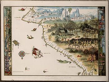
The title of the book refers to the sixteenth century Dieppe mapsDieppe maps
The Dieppe maps are a series of world maps produced in Dieppe, France, in the 1540s, 1550s and 1560s. They are large hand-produced maps, commissioned for wealthy and royal patrons, including Henry II of France and Henry VIII of England...
of France
France
The French Republic , The French Republic , The French Republic , (commonly known as France , is a unitary semi-presidential republic in Western Europe with several overseas territories and islands located on other continents and in the Indian, Pacific, and Atlantic oceans. Metropolitan France...
which in part show land in a continent extending south of the Tropic of Capricorn
Tropic of Capricorn
The Tropic of Capricorn, or Southern tropic, marks the most southerly latitude on the Earth at which the Sun can be directly overhead. This event occurs at the December solstice, when the southern hemisphere is tilted towards the Sun to its maximum extent.Tropic of Capricorn is one of the five...
, that is in the area of Australia
Australia
Australia , officially the Commonwealth of Australia, is a country in the Southern Hemisphere comprising the mainland of the Australian continent, the island of Tasmania, and numerous smaller islands in the Indian and Pacific Oceans. It is the world's sixth-largest country by total area...
. Trickett claims that the Portuguese
Portugal
Portugal , officially the Portuguese Republic is a country situated in southwestern Europe on the Iberian Peninsula. Portugal is the westernmost country of Europe, and is bordered by the Atlantic Ocean to the West and South and by Spain to the North and East. The Atlantic archipelagos of the...
were the first Europe
Europe
Europe is, by convention, one of the world's seven continents. Comprising the westernmost peninsula of Eurasia, Europe is generally 'divided' from Asia to its east by the watershed divides of the Ural and Caucasus Mountains, the Ural River, the Caspian and Black Seas, and the waterways connecting...
ans to discover Australia
Australia
Australia , officially the Commonwealth of Australia, is a country in the Southern Hemisphere comprising the mainland of the Australian continent, the island of Tasmania, and numerous smaller islands in the Indian and Pacific Oceans. It is the world's sixth-largest country by total area...
, between 1519 – 23, well before the first recognized landfall of Europe
Europe
Europe is, by convention, one of the world's seven continents. Comprising the westernmost peninsula of Eurasia, Europe is generally 'divided' from Asia to its east by the watershed divides of the Ural and Caucasus Mountains, the Ural River, the Caspian and Black Seas, and the waterways connecting...
ans in Australia
Australia
Australia , officially the Commonwealth of Australia, is a country in the Southern Hemisphere comprising the mainland of the Australian continent, the island of Tasmania, and numerous smaller islands in the Indian and Pacific Oceans. It is the world's sixth-largest country by total area...
in 1606 by Willem Janszoon
Willem Janszoon
Willem Janszoon , Dutch navigator and colonial governor, is probably the first European known to have seen the coast of Australia. His name is sometimes abbreviated to Willem Jansz....
. According to Trickett, the first European to sight Australia
Australia
Australia , officially the Commonwealth of Australia, is a country in the Southern Hemisphere comprising the mainland of the Australian continent, the island of Tasmania, and numerous smaller islands in the Indian and Pacific Oceans. It is the world's sixth-largest country by total area...
may have been Diogo Pacheco, a relative of Duarte Pacheco
Duarte Pacheco Pereira
Duarte Pacheco Pereira, called the Great, was a 15th century Portuguese sea captain, soldier, explorer and cartographer. He travelled particularly in the central Atlantic Ocean west of the Cape Verde islands, along the coast of West Africa and to India...
, at Napier Broome Bay in the Kimberleys in north-western Australia
Australia
Australia , officially the Commonwealth of Australia, is a country in the Southern Hemisphere comprising the mainland of the Australian continent, the island of Tasmania, and numerous smaller islands in the Indian and Pacific Oceans. It is the world's sixth-largest country by total area...
in 1520. Using an account from the history of the Portuguese
Portugal
Portugal , officially the Portuguese Republic is a country situated in southwestern Europe on the Iberian Peninsula. Portugal is the westernmost country of Europe, and is bordered by the Atlantic Ocean to the West and South and by Spain to the North and East. The Atlantic archipelagos of the...
empire in Asia by João de Barros
João de Barros
João de Barros , called the Portuguese Livy, is one of the first great Portuguese historians, most famous for his Décadas da Ásia , a history of the Portuguese in India and Asia.-Early years:...
, Décadas da Ásia, Trickett argues Pacheco was killed there in a battle with Aborigines
Indigenous Australians
Indigenous Australians are the original inhabitants of the Australian continent and nearby islands. The Aboriginal Indigenous Australians migrated from the Indian continent around 75,000 to 100,000 years ago....
while searching for gold. Trickett claims the Carronade Island
Carronade Island
Carronade Island lies off the northern coast of Western Australia .-References:* Green, Jeremy N. The Carronade Island guns and Australia's early visitors. Great circle, Vol.4, no.1 , p.73-83....
cannons, originate from this voyage.
Most of the book, however, focuses on the claimed voyage of a fleet of four ships commanded by Cristóvão de Mendonça
Cristóvão de Mendonça
Cristóvão de Mendonça was a Portuguese sailor and statesman who was active in South East Asia in the 16th century.-Mendonça in João de Barros's Décadas da Ásia:...
, along the eastern and southern coasts of Australia
Australia
Australia , officially the Commonwealth of Australia, is a country in the Southern Hemisphere comprising the mainland of the Australian continent, the island of Tasmania, and numerous smaller islands in the Indian and Pacific Oceans. It is the world's sixth-largest country by total area...
then to New Zealand
New Zealand
New Zealand is an island country in the south-western Pacific Ocean comprising two main landmasses and numerous smaller islands. The country is situated some east of Australia across the Tasman Sea, and roughly south of the Pacific island nations of New Caledonia, Fiji, and Tonga...
shortly afterwards, and another Portuguese
Portugal
Portugal , officially the Portuguese Republic is a country situated in southwestern Europe on the Iberian Peninsula. Portugal is the westernmost country of Europe, and is bordered by the Atlantic Ocean to the West and South and by Spain to the North and East. The Atlantic archipelagos of the...
voyage along the west coast. Trickett uses one of the Dieppe maps
Dieppe maps
The Dieppe maps are a series of world maps produced in Dieppe, France, in the 1540s, 1550s and 1560s. They are large hand-produced maps, commissioned for wealthy and royal patrons, including Henry II of France and Henry VIII of England...
in the highly decorated "Vallard" atlas of 1547 to demonstrate this. Trickett claims that Mendonça
Cristóvão de Mendonça
Cristóvão de Mendonça was a Portuguese sailor and statesman who was active in South East Asia in the 16th century.-Mendonça in João de Barros's Décadas da Ásia:...
sailed down the east coast of Australia
Australia
Australia , officially the Commonwealth of Australia, is a country in the Southern Hemisphere comprising the mainland of the Australian continent, the island of Tasmania, and numerous smaller islands in the Indian and Pacific Oceans. It is the world's sixth-largest country by total area...
, sailing into Botany Bay
Botany Bay
Botany Bay is a bay in Sydney, New South Wales, a few kilometres south of the Sydney central business district. The Cooks River and the Georges River are the two major tributaries that flow into the bay...
, and then around Wilsons Promontory
Wilsons Promontory
Wilsons Promontory is a peninsula that forms the southernmost part of the Australian mainland and is located at . South Point at is the southernmost tip of Wilsons Promontory and hence of mainland Australia...
to Kangaroo Island
Kangaroo Island
Kangaroo Island is Australia's third-largest island after Tasmania and Melville Island. It is southwest of Adelaide at the entrance of Gulf St Vincent. Its closest point to the mainland is off Cape Jervis, on the tip of the Fleurieu Peninsula in the state of South Australia. The island is long...
, before returning to Portuguese
Portugal
Portugal , officially the Portuguese Republic is a country situated in southwestern Europe on the Iberian Peninsula. Portugal is the westernmost country of Europe, and is bordered by the Atlantic Ocean to the West and South and by Spain to the North and East. The Atlantic archipelagos of the...
controlled Malacca
Malacca
Malacca , dubbed The Historic State or Negeri Bersejarah among locals) is the third smallest Malaysian state, after Perlis and Penang. It is located in the southern region of the Malay Peninsula, on the Straits of Malacca. It borders Negeri Sembilan to the north and the state of Johor to the south...
via the North Island of New Zealand. He also claims the Portuguese
Portugal
Portugal , officially the Portuguese Republic is a country situated in southwestern Europe on the Iberian Peninsula. Portugal is the westernmost country of Europe, and is bordered by the Atlantic Ocean to the West and South and by Spain to the North and East. The Atlantic archipelagos of the...
charted the Western Australia
Western Australia
Western Australia is a state of Australia, occupying the entire western third of the Australian continent. It is bounded by the Indian Ocean to the north and west, the Great Australian Bight and Indian Ocean to the south, the Northern Territory to the north-east and South Australia to the south-east...
n coast, as far south as the south west tip of Australia
Australia
Australia , officially the Commonwealth of Australia, is a country in the Southern Hemisphere comprising the mainland of the Australian continent, the island of Tasmania, and numerous smaller islands in the Indian and Pacific Oceans. It is the world's sixth-largest country by total area...
. Trickett claims that the French
France
The French Republic , The French Republic , The French Republic , (commonly known as France , is a unitary semi-presidential republic in Western Europe with several overseas territories and islands located on other continents and in the Indian, Pacific, and Atlantic oceans. Metropolitan France...
Vallard maps
Dieppe maps
The Dieppe maps are a series of world maps produced in Dieppe, France, in the 1540s, 1550s and 1560s. They are large hand-produced maps, commissioned for wealthy and royal patrons, including Henry II of France and Henry VIII of England...
were composed of several portolan chart
Portolan chart
Portolan charts are navigational maps based on realistic descriptions of harbours and coasts. They were first made in the 14th century in Italy, Portugal and Spain...
s that were incorrectly assembled from now lost Portuguese
Portugal
Portugal , officially the Portuguese Republic is a country situated in southwestern Europe on the Iberian Peninsula. Portugal is the westernmost country of Europe, and is bordered by the Atlantic Ocean to the West and South and by Spain to the North and East. The Atlantic archipelagos of the...
charts. Trickett adjusts parts of the Vallard maps
Dieppe maps
The Dieppe maps are a series of world maps produced in Dieppe, France, in the 1540s, 1550s and 1560s. They are large hand-produced maps, commissioned for wealthy and royal patrons, including Henry II of France and Henry VIII of England...
by rotating them 90 degrees, giving what he claims is a reasonably accurate depiction of Australia's
Australia
Australia , officially the Commonwealth of Australia, is a country in the Southern Hemisphere comprising the mainland of the Australian continent, the island of Tasmania, and numerous smaller islands in the Indian and Pacific Oceans. It is the world's sixth-largest country by total area...
eastern, southern and western coasts
Trickett goes through almost every written location on the Vallard maps
Dieppe maps
The Dieppe maps are a series of world maps produced in Dieppe, France, in the 1540s, 1550s and 1560s. They are large hand-produced maps, commissioned for wealthy and royal patrons, including Henry II of France and Henry VIII of England...
, giving an English translation and explaining where he believes the place is located. He also mentions the Mahogany Ship
Mahogany Ship
The Mahogany Ship refers to a putative, early shipwreck that is purported to lie beneath the sand in the Armstrong Bay area, approximately 3 to 6 kilometres west of Warrnambool in southwest Victoria, Australia...
, the ruins at Bittangabee Bay
Bittangabee Bay
Bittangabee Bay is a tiny picturesque bay on the rugged and remote stretch of coastline south of Eden, New South Wales in New South Wales . The bay is located in Ben Boyd National Park, with a small camping ground and facilities maintained by...
on the south coast of New South Wales
New South Wales
New South Wales is a state of :Australia, located in the east of the country. It is bordered by Queensland, Victoria and South Australia to the north, south and west respectively. To the east, the state is bordered by the Tasman Sea, which forms part of the Pacific Ocean. New South Wales...
, various Aboriginal legends and alleged linguistic similarities, a 500-year-old [Portuguese]] lead sinker found on the Queensland
Queensland
Queensland is a state of Australia, occupying the north-eastern section of the mainland continent. It is bordered by the Northern Territory, South Australia and New South Wales to the west, south-west and south respectively. To the east, Queensland is bordered by the Coral Sea and Pacific Ocean...
coast and the "Spanish Helmet" of Wellington Harbour as further evidence of a Portuguese
Portugal
Portugal , officially the Portuguese Republic is a country situated in southwestern Europe on the Iberian Peninsula. Portugal is the westernmost country of Europe, and is bordered by the Atlantic Ocean to the West and South and by Spain to the North and East. The Atlantic archipelagos of the...
discovery of Australia
Australia
Australia , officially the Commonwealth of Australia, is a country in the Southern Hemisphere comprising the mainland of the Australian continent, the island of Tasmania, and numerous smaller islands in the Indian and Pacific Oceans. It is the world's sixth-largest country by total area...
and New Zealand
New Zealand
New Zealand is an island country in the south-western Pacific Ocean comprising two main landmasses and numerous smaller islands. The country is situated some east of Australia across the Tasman Sea, and roughly south of the Pacific island nations of New Caledonia, Fiji, and Tonga...
.
An example of approach - Botany Bay

Botany Bay
Botany Bay is a bay in Sydney, New South Wales, a few kilometres south of the Sydney central business district. The Cooks River and the Georges River are the two major tributaries that flow into the bay...
to the point where Sydney Airport
Sydney Airport
Sydney Airport may refer to:* Sydney Airport, also known as Kingsford Smith International Airport, in Sydney, Australia* Sydney/J.A. Douglas McCurdy Airport, in Nova Scotia, Canada...
runways could be drawn on it. Trickett’s Botany Bay
Botany Bay
Botany Bay is a bay in Sydney, New South Wales, a few kilometres south of the Sydney central business district. The Cooks River and the Georges River are the two major tributaries that flow into the bay...
is "Baia Neve" on the Vallard Map, and on p. 155 Trickett provides a sketch map of the bay with Sydney Airport
Sydney Airport
Sydney Airport may refer to:* Sydney Airport, also known as Kingsford Smith International Airport, in Sydney, Australia* Sydney/J.A. Douglas McCurdy Airport, in Nova Scotia, Canada...
runways drawn on it to the same scale. He acknowledges the bay is "too large to be Botany Bay
Botany Bay
Botany Bay is a bay in Sydney, New South Wales, a few kilometres south of the Sydney central business district. The Cooks River and the Georges River are the two major tributaries that flow into the bay...
". He explains that sixteenth century map-makers "enlarge(d) … important sections of their charts," such as this bay, hence its exaggerated size. The Vallard map original also shows two large islands in the bay and seven islands just outside the mouth of the bay. Trickett explained the islands inside the bay as Bare Island and a large mudflat, which he believed appeared as a large island to the Portuguese explorers. The seven islands outside the bay he identifies as a misplacing of the Five Islands Group (50 km away near Wollongong); a representation of the North Head of Sydney Harbour and a representation of Cape Three Points (now Bouddi
Bouddi, New South Wales
Bouddi is a coastal south-eastern suburb of the Central Coast region of New South Wales, Australia. It is located within the City of Gosford local government area. Bouddi is the Aboriginal word for the heart....
, 70 km away near Broken Bay
Broken Bay
Broken Bay is a large inlet of the Pacific Ocean located about 50 km north of Sydney on the coast of New South Wales, Australia, and is the first major bay north of Sydney's Port Jackson.- Geography :...
).
Criticism of Trickett's theories
Following its initial reception on-line and in the popular press, a number of criticisms of Trickett's book have appeared since its publication. The most notable criticism coming from Associate Professor (Spanish and Portuguese) W.A.R.(Bill) Richardson. Trickett perhaps attempted to pre-empt some criticisms from academics by providing counter arguments in advance. However, although he repeatedly criticises “orthodox academics” for ignoring or denigrating the theory of Portuguese discovery of AustraliaTheory of Portuguese discovery of Australia
Although most historians hold that the European discovery of Australia began in 1606 with the voyage of the Dutch navigator Willem Janszoon on board the Duyfken, a theory exists that a Portuguese expedition arrived in Australia between 1521 and 1524...
, Trickett acknowledges Beyond Capricorn is "not written as an academic treatise".
Trickett’s approach of using only one Dieppe map
Dieppe maps
The Dieppe maps are a series of world maps produced in Dieppe, France, in the 1540s, 1550s and 1560s. They are large hand-produced maps, commissioned for wealthy and royal patrons, including Henry II of France and Henry VIII of England...
as the basis for his book, without significant reference to any of the other existing Dieppe maps
Dieppe maps
The Dieppe maps are a series of world maps produced in Dieppe, France, in the 1540s, 1550s and 1560s. They are large hand-produced maps, commissioned for wealthy and royal patrons, including Henry II of France and Henry VIII of England...
, has been questioned. The Vallard map of 1547 is not the first of the Dieppe maps
Dieppe maps
The Dieppe maps are a series of world maps produced in Dieppe, France, in the 1540s, 1550s and 1560s. They are large hand-produced maps, commissioned for wealthy and royal patrons, including Henry II of France and Henry VIII of England...
and Bill Richardson argues Peter Trickett incorrectly “assumes the unknown Vallard cartographer had access to much more information” because it contains more place names. Richardson adds that "the hybrid inscriptions [of the Vallard] are in an astonishing jumble of languages", many of which Trickett misreads or misinterprets; suggesting for example that the island Illa do Aljofar may have Polynesian origins.
Trickett also reproduces a number of sketch maps, comparing Terra Java/Jave La Grande of the A3 sized pages of the Vallard atlas with modern detailed knowledge of the Australian coast, but without showing any scale. Richardson argues this practice misleads a reader, and he previously argued Kenneth McIntyre’s comparative sketches also misled in the same way. The issues in providing such sketch maps for comparison purposes are highlighted in Trickett’s sketch map copy of Illa Do Magna, where he compares it to a rough sketch map of New Zealand’s North Island. Richardson adds that the lack of scale used in Beyond Capricorn’s sketch maps causes the reader "to fail to realise that [Trickett’s adjusted] 'Wilsons Promontory' is some 17 degrees, nearly 2,000 kilometres, south of the real Wilsons Promontory."
Commenting in 1985 on other writers who compared Australia’s coast with the Dieppe Maps, Richardson wrote; "it is difficult not to express admiration for the extreme ingenuity exercised in their endeavours to 'correct' the Jave La Grande outline in order to compel it to conform more closely to the known outline of Australia." Writing in 2007 for an Australian mapmaking journal, he suggests Trickett has also taken an approach of “if evidence does not suit a theory, one solution is to alter it.”
In an article in The Globe in 2009, Robert J. King refers to Beyond Capricorn but argues that Jave la Grande is a theoretical construction, an artifact of 16th century cosmography. He points out that the geographers and map makers of the Renaissance struggled to bridge the gap from the world-view inherited from Graeco-Roman antiquity, as set out in Claudius Ptolemy's Geography, and a map of the world that would take account of the new geographical information obtained during the Age of Discoveries. The Dieppe world maps reflected the state of geographical knowledge of their time, both actual and theoretical. Accordingly, Java Major, or Jave la Grande, was shown as a promontory of the undiscovered antarctic continent of Terra Australis
Terra Australis
Terra Australis, Terra Australis Ignota or Terra Australis Incognita was a hypothesized continent appearing on European maps from the 15th to the 18th century...
. King argues that Jave la Grande on the Dieppe maps represents one of Marco Polo's pair of Javas (Major or Minor), misplaced far to the south of its actual location and attached to a greatly enlarged Terra Australis
Terra Australis
Terra Australis, Terra Australis Ignota or Terra Australis Incognita was a hypothesized continent appearing on European maps from the 15th to the 18th century...
: it does not represent Australia discovered by unknown Portuguese voyagers.