
Terra Australis
Encyclopedia
Terra Australis, Terra Australis Ignota or Terra Australis Incognita (Latin for "the unknown land of the South") was a hypothesized continent
appearing on European maps from the 15th to the 18th century. Other names for the continent include Magallanica or Magellanica ("the land of Magellan
"), La Australia del Espíritu Santo (Spanish: "the southern land of the Holy Spirit"), and La grande isle de Java (French: "the great island of Java
"). Terra Australis was one of several names applied to the actual continent of Australia, after its European discovery; it is the root of the continent's modern name (see Etymology, at Australia
).
 The notion of Terra Australis was introduced by Aristotle
. His ideas were later expanded by Ptolemy
(1st century AD), who believed that the Indian Ocean
was enclosed on the south by land, and that the lands of the Northern Hemisphere
should be balanced by land in the south
. Ptolemy's maps, which became well-known in Europe during the Renaissance
, did not actually depict such a continent, but they did show an Africa which had no southern oceanic boundary (and which therefore might extend all the way to the South Pole), and also raised the possibility that the Indian Ocean
was entirely enclosed by land. Christian thinkers did not discount the idea that there might be land beyond the southern seas, but the issue of whether it could be inhabited was controversial.
, from the late 15th century on, proved that Africa was almost entirely surrounded by sea, and that the Indian Ocean was accessible from both west and east. These discoveries reduced the area where the continent could be found; however, many cartographers held to Aristotle's opinion. Scientists, such as Gerardus Mercator
(1569) and Alexander Dalrymple
as late as 1767 argued for its existence, with such arguments as that there should be a large landmass
in the south
as a counterweight
to the known landmasses in the Northern Hemisphere. As new lands were discovered, they were often assumed to be parts of the hypothetical continent.
Terra Australis was depicted on the mid-16th-century Dieppe maps
, where its coastline appeared just south of the islands of the East Indies; it was often elaborately charted, with a wealth of fictitious detail. There was much interest in Terra Australis among Norman
and Breton
merchants at that time. In 1566 and 1570, Francisque and André d'Albaigne
presented Gaspard de Coligny
, Admiral of France, with projects for establishing relations with the Austral lands. Although the Admiral gave favourable consideration to these initiatives, they came to nought when Coligny was killed in 1572
.
 Juan Fernandez, sailing from Chile in 1576, claimed he had discovered the Southern Continent. The Polus Antarcticus map of 1641 by Henricus Hondius, bears the inscription: ”Insulas esse a Nova Guinea usque ad Fretum Magellanicum affirmat Hernandus Galego, qui ad eas explorandas missus fuit a Rege Hispaniae Anno 1576 (Hernando Gallego, who in the year 1576 was sent by the King of Spain to explore them, affirms that there are islands from New Guinea up to the Strait of Magellan)”.
Luis Váez de Torres, a Galician
or Portuguese
navigator working for the Spanish Crown, proved the existence of a passage south of New Guinea, now known as Torres Strait
.
Pedro Fernandes de Queirós
, another Portuguese navigator sailing for the Spanish Crown, saw a large island south of New Guinea in 1606, which he named La Australia del Espiritu Santo. He represented this to the King of Spain
as the Terra Australis incognita.
Isaac and Jacob Le Maire
established the Australische Compagnie (Australian Company) in 1615 to trade with Terra Australis, which they called "Australia".
Alexander Dalrymple
, the Examiner of Sea Journals for the English East India Company,whilst translating some Spanish documents captured in the Philippines in 1752, found de Torres's testimony. This discovery led Dalrymple to publish the Historical Collection of the Several Voyages and Discoveries in the South Pacific Ocean in 1770-1771. Dalrymple presented a beguiling tableau of the Terra Australis, or Southern Continent:
Dalrymple's claim of the existence of an unknown continent aroused widespread interest and prompted the British government in 1769 to order James Cook
in HM Bark Endeavour
to seek out the Southern Continent to the South and West of Tahiti. The expedition eventually led in 1770 to the British discovery and charting of the Eastern coastline of Australia.
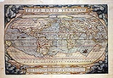
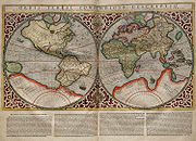
The cartographic depictions of the southern continent in the 16th and early 17th centuries, as might be expected for a concept based on such abundant conjecture and minimal data, varied wildly from map to map; in general, the continent shrank as potential locations were reinterpreted. At its largest, the continent included Tierra del Fuego
, separated from South America by a small strait; New Guinea
; and what would come to be called Australia
. In Ortelius's atlas Theatrum Orbis Terrarum, published in 1570, Terra Australis extends north of the Tropic of Capricorn in the Pacific Ocean.
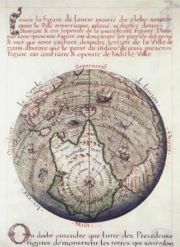
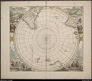
As long as it appeared on maps at all, the continent minimally included the unexplored lands around the South Pole
, but generally much larger than the real Antarctica, spreading far north – especially in the Pacific Ocean
. New Zealand
, first seen by the Dutch
explorer Abel Tasman
in 1642, was regarded by some as a part of the continent.
 Over the centuries the idea of Terra Australis gradually lost its hold. In 1615, Jacob le Maire and Willem Schouten
's rounding of Cape Horn proved that Tierra del Fuego
was a relatively small island, while in 1642 Abel Tasman
's first pacific voyage proved that Australia was not part of the mythical southern continent. Much later, James Cook
sailed around most of New Zealand in 1770, showing that even it could not be part of a large continent. On his second voyage he circumnavigated
the globe at a very high southern latitude
, at some places even crossing the south polar circle
, showing that any possible southern continent must lie well within the cold polar areas. There could be no extension into regions with a temperate climate, as had been thought before. In 1814, Matthew Flinders
published the book A Voyage to Terra Australis
in which he wrote:
...with the accompanying note at the bottom of the page:
Flinders had concluded that the Terra Australis as hypothesized by Aristotle
and Ptolemy
did not exist, so he wanted the name applied to what he saw as the next best thing: "Australia
". His conclusion would soon be revealed as a mistake, but by that time the name had stuck.
was finally sighted in the hypothetical area of Terra Australis on January 27, 1820 by Russian Fabian Gottlieb von Bellingshausen
, the first confirmed sighting.
Continent
A continent is one of several very large landmasses on Earth. They are generally identified by convention rather than any strict criteria, with seven regions commonly regarded as continents—they are : Asia, Africa, North America, South America, Antarctica, Europe, and Australia.Plate tectonics is...
appearing on European maps from the 15th to the 18th century. Other names for the continent include Magallanica or Magellanica ("the land of Magellan
Ferdinand Magellan
Ferdinand Magellan was a Portuguese explorer. He was born in Sabrosa, in northern Portugal, and served King Charles I of Spain in search of a westward route to the "Spice Islands" ....
"), La Australia del Espíritu Santo (Spanish: "the southern land of the Holy Spirit"), and La grande isle de Java (French: "the great island of Java
Java
Java is an island of Indonesia. With a population of 135 million , it is the world's most populous island, and one of the most densely populated regions in the world. It is home to 60% of Indonesia's population. The Indonesian capital city, Jakarta, is in west Java...
"). Terra Australis was one of several names applied to the actual continent of Australia, after its European discovery; it is the root of the continent's modern name (see Etymology, at Australia
Australia
Australia , officially the Commonwealth of Australia, is a country in the Southern Hemisphere comprising the mainland of the Australian continent, the island of Tasmania, and numerous smaller islands in the Indian and Pacific Oceans. It is the world's sixth-largest country by total area...
).
Origins
Aristotle
Aristotle was a Greek philosopher and polymath, a student of Plato and teacher of Alexander the Great. His writings cover many subjects, including physics, metaphysics, poetry, theater, music, logic, rhetoric, linguistics, politics, government, ethics, biology, and zoology...
. His ideas were later expanded by Ptolemy
Ptolemy
Claudius Ptolemy , was a Roman citizen of Egypt who wrote in Greek. He was a mathematician, astronomer, geographer, astrologer, and poet of a single epigram in the Greek Anthology. He lived in Egypt under Roman rule, and is believed to have been born in the town of Ptolemais Hermiou in the...
(1st century AD), who believed that the Indian Ocean
Indian Ocean
The Indian Ocean is the third largest of the world's oceanic divisions, covering approximately 20% of the water on the Earth's surface. It is bounded on the north by the Indian Subcontinent and Arabian Peninsula ; on the west by eastern Africa; on the east by Indochina, the Sunda Islands, and...
was enclosed on the south by land, and that the lands of the Northern Hemisphere
Northern Hemisphere
The Northern Hemisphere is the half of a planet that is north of its equator—the word hemisphere literally means “half sphere”. It is also that half of the celestial sphere north of the celestial equator...
should be balanced by land in the south
Southern Hemisphere
The Southern Hemisphere is the part of Earth that lies south of the equator. The word hemisphere literally means 'half ball' or "half sphere"...
. Ptolemy's maps, which became well-known in Europe during the Renaissance
Renaissance
The Renaissance was a cultural movement that spanned roughly the 14th to the 17th century, beginning in Italy in the Late Middle Ages and later spreading to the rest of Europe. The term is also used more loosely to refer to the historical era, but since the changes of the Renaissance were not...
, did not actually depict such a continent, but they did show an Africa which had no southern oceanic boundary (and which therefore might extend all the way to the South Pole), and also raised the possibility that the Indian Ocean
Indian Ocean
The Indian Ocean is the third largest of the world's oceanic divisions, covering approximately 20% of the water on the Earth's surface. It is bounded on the north by the Indian Subcontinent and Arabian Peninsula ; on the west by eastern Africa; on the east by Indochina, the Sunda Islands, and...
was entirely enclosed by land. Christian thinkers did not discount the idea that there might be land beyond the southern seas, but the issue of whether it could be inhabited was controversial.
Mapping the Southern Continent
Explorers of the Age of DiscoveryAge of Discovery
The Age of Discovery, also known as the Age of Exploration and the Great Navigations , was a period in history starting in the early 15th century and continuing into the early 17th century during which Europeans engaged in intensive exploration of the world, establishing direct contacts with...
, from the late 15th century on, proved that Africa was almost entirely surrounded by sea, and that the Indian Ocean was accessible from both west and east. These discoveries reduced the area where the continent could be found; however, many cartographers held to Aristotle's opinion. Scientists, such as Gerardus Mercator
Gerardus Mercator
thumb|right|200px|Gerardus MercatorGerardus Mercator was a cartographer, born in Rupelmonde in the Hapsburg County of Flanders, part of the Holy Roman Empire. He is remembered for the Mercator projection world map, which is named after him...
(1569) and Alexander Dalrymple
Alexander Dalrymple
Alexander Dalrymple was a Scottish geographer and the first Hydrographer of the British Admiralty. He was the main proponent of the theory that there existed a vast undiscovered continent in the South Pacific, Terra Australis Incognita...
as late as 1767 argued for its existence, with such arguments as that there should be a large landmass
Landmass
A landmass is a contiguous area of land surrounded by ocean. Although it may be most often written as one word to distinguish it from the usage "land mass"—the measure of land area—it is also used as two words.Landmasses include:*supercontinents...
in the south
Southern Hemisphere
The Southern Hemisphere is the part of Earth that lies south of the equator. The word hemisphere literally means 'half ball' or "half sphere"...
as a counterweight
Counterweight
A counterweight is an equivalent counterbalancing weight that balances a load.-Uses:A counterweight is often used in traction lifts , cranes and funfair rides...
to the known landmasses in the Northern Hemisphere. As new lands were discovered, they were often assumed to be parts of the hypothetical continent.
Terra Australis was depicted on the mid-16th-century Dieppe maps
Dieppe maps
The Dieppe maps are a series of world maps produced in Dieppe, France, in the 1540s, 1550s and 1560s. They are large hand-produced maps, commissioned for wealthy and royal patrons, including Henry II of France and Henry VIII of England...
, where its coastline appeared just south of the islands of the East Indies; it was often elaborately charted, with a wealth of fictitious detail. There was much interest in Terra Australis among Norman
Normandy
Normandy is a geographical region corresponding to the former Duchy of Normandy. It is in France.The continental territory covers 30,627 km² and forms the preponderant part of Normandy and roughly 5% of the territory of France. It is divided for administrative purposes into two régions:...
and Breton
Brittany
Brittany is a cultural and administrative region in the north-west of France. Previously a kingdom and then a duchy, Brittany was united to the Kingdom of France in 1532 as a province. Brittany has also been referred to as Less, Lesser or Little Britain...
merchants at that time. In 1566 and 1570, Francisque and André d'Albaigne
André d'Albaigne
Francisque and André d’Albaigne were 16th-century Italian merchants from the city of Lucca. Their name was Dalbagnio, according to a notary act of 1567 involving their brother Pellegrino .-d'Albaigne proposal to colonize Terra Australis:-Francisque d’Albaigne :From Lisbon Francisque and André...
presented Gaspard de Coligny
Gaspard de Coligny
Gaspard de Coligny , Seigneur de Châtillon, was a French nobleman and admiral, best remembered as a disciplined Huguenot leader in the French Wars of Religion.-Ancestry:...
, Admiral of France, with projects for establishing relations with the Austral lands. Although the Admiral gave favourable consideration to these initiatives, they came to nought when Coligny was killed in 1572
St. Bartholomew's Day massacre
The St. Bartholomew's Day massacre in 1572 was a targeted group of assassinations, followed by a wave of Roman Catholic mob violence, both directed against the Huguenots , during the French Wars of Religion...
.
Luis Váez de Torres, a Galician
Galician
Galician can refer to:* Something of, from, or related to Galicia * Galician language* Galician people, an ethnic group of Galicia, Spain* Galician wine, wine produced in Galicia, Spain*Galician cuisine- See also :* Galicia...
or Portuguese
Portuguese people
The Portuguese are a nation and ethnic group native to the country of Portugal, in the west of the Iberian peninsula of south-west Europe. Their language is Portuguese, and Roman Catholicism is the predominant religion....
navigator working for the Spanish Crown, proved the existence of a passage south of New Guinea, now known as Torres Strait
Torres Strait
The Torres Strait is a body of water which lies between Australia and the Melanesian island of New Guinea. It is approximately wide at its narrowest extent. To the south is Cape York Peninsula, the northernmost continental extremity of the Australian state of Queensland...
.
Pedro Fernandes de Queirós
Pedro Fernandes de Queirós
Pedro Fernandes de Queirós , was a Portuguese navigator best known for his involvement with Spanish voyages of discovery in the Pacific Ocean, in particular the 1595-1596 voyage of Alvaro de Mendaña de Neira, and for leading a 1605-1606 expedition which crossed the Pacific in search of Terra...
, another Portuguese navigator sailing for the Spanish Crown, saw a large island south of New Guinea in 1606, which he named La Australia del Espiritu Santo. He represented this to the King of Spain
Spain
Spain , officially the Kingdom of Spain languages]] under the European Charter for Regional or Minority Languages. In each of these, Spain's official name is as follows:;;;;;;), is a country and member state of the European Union located in southwestern Europe on the Iberian Peninsula...
as the Terra Australis incognita.
Isaac and Jacob Le Maire
Jacob Le Maire
Jacob Le Maire was a Dutch mariner who circumnavigated the earth in 1615-16. The strait between Tierra del Fuego and Isla de los Estados was named the Le Maire Strait in his honor, though not without controversy...
established the Australische Compagnie (Australian Company) in 1615 to trade with Terra Australis, which they called "Australia".
Alexander Dalrymple
Alexander Dalrymple
Alexander Dalrymple was a Scottish geographer and the first Hydrographer of the British Admiralty. He was the main proponent of the theory that there existed a vast undiscovered continent in the South Pacific, Terra Australis Incognita...
, the Examiner of Sea Journals for the English East India Company,whilst translating some Spanish documents captured in the Philippines in 1752, found de Torres's testimony. This discovery led Dalrymple to publish the Historical Collection of the Several Voyages and Discoveries in the South Pacific Ocean in 1770-1771. Dalrymple presented a beguiling tableau of the Terra Australis, or Southern Continent:
The number of inhabitants in the Southern Continent is probably more than 50 millions, considering the extent, from the eastern part discovered by Juan Fernandez, to the western coast seen by Tasman, is about 100 deg. of longitude, which in the latitude of 40 deg. amounts to 4596 geographic, or 5323 stature miles. This is a greater extent than the whole civilized part of Asia, from Turkey to the eastern extremity of China. There is at present no trade from Europe thither, though the scraps from this table would be sufficient to maintain the power, dominion, and sovereignty of Britain, by employing all its manufacturers and ships. Whoever considers the Peruvian empire, where arts and industry flourished under one of the wisest systems of government, which was founded by a stranger, must have very sanguine expectations of the southern continent, from whence it is more than probable Mango Capac, the first Inca, was derived, and must be convinced that the country, from whence Mango Capac introduced the comforts of civilized life, cannot fail of amply rewarding the fortunate people who shall bestow letters instead of quippos (quipus), and iron in place of more awkward substitutes.
Dalrymple's claim of the existence of an unknown continent aroused widespread interest and prompted the British government in 1769 to order James Cook
James Cook
Captain James Cook, FRS, RN was a British explorer, navigator and cartographer who ultimately rose to the rank of captain in the Royal Navy...
in HM Bark Endeavour
HM Bark Endeavour
HMS Endeavour, also known as HM Bark Endeavour, was a British Royal Navy research vessel commanded by Lieutenant James Cook on his first voyage of discovery, to Australia and New Zealand from 1769 to 1771....
to seek out the Southern Continent to the South and West of Tahiti. The expedition eventually led in 1770 to the British discovery and charting of the Eastern coastline of Australia.
The cartographic depictions of the southern continent in the 16th and early 17th centuries, as might be expected for a concept based on such abundant conjecture and minimal data, varied wildly from map to map; in general, the continent shrank as potential locations were reinterpreted. At its largest, the continent included Tierra del Fuego
Tierra del Fuego
Tierra del Fuego is an archipelago off the southernmost tip of the South American mainland, across the Strait of Magellan. The archipelago consists of a main island Isla Grande de Tierra del Fuego divided between Chile and Argentina with an area of , and a group of smaller islands including Cape...
, separated from South America by a small strait; New Guinea
New Guinea
New Guinea is the world's second largest island, after Greenland, covering a land area of 786,000 km2. Located in the southwest Pacific Ocean, it lies geographically to the east of the Malay Archipelago, with which it is sometimes included as part of a greater Indo-Australian Archipelago...
; and what would come to be called Australia
Australia
Australia , officially the Commonwealth of Australia, is a country in the Southern Hemisphere comprising the mainland of the Australian continent, the island of Tasmania, and numerous smaller islands in the Indian and Pacific Oceans. It is the world's sixth-largest country by total area...
. In Ortelius's atlas Theatrum Orbis Terrarum, published in 1570, Terra Australis extends north of the Tropic of Capricorn in the Pacific Ocean.
As long as it appeared on maps at all, the continent minimally included the unexplored lands around the South Pole
South Pole
The South Pole, also known as the Geographic South Pole or Terrestrial South Pole, is one of the two points where the Earth's axis of rotation intersects its surface. It is the southernmost point on the surface of the Earth and lies on the opposite side of the Earth from the North Pole...
, but generally much larger than the real Antarctica, spreading far north – especially in the Pacific Ocean
Pacific Ocean
The Pacific Ocean is the largest of the Earth's oceanic divisions. It extends from the Arctic in the north to the Southern Ocean in the south, bounded by Asia and Australia in the west, and the Americas in the east.At 165.2 million square kilometres in area, this largest division of the World...
. New Zealand
New Zealand
New Zealand is an island country in the south-western Pacific Ocean comprising two main landmasses and numerous smaller islands. The country is situated some east of Australia across the Tasman Sea, and roughly south of the Pacific island nations of New Caledonia, Fiji, and Tonga...
, first seen by the Dutch
Netherlands
The Netherlands is a constituent country of the Kingdom of the Netherlands, located mainly in North-West Europe and with several islands in the Caribbean. Mainland Netherlands borders the North Sea to the north and west, Belgium to the south, and Germany to the east, and shares maritime borders...
explorer Abel Tasman
Abel Tasman
Abel Janszoon Tasman was a Dutch seafarer, explorer, and merchant, best known for his voyages of 1642 and 1644 in the service of the VOC . His was the first known European expedition to reach the islands of Van Diemen's Land and New Zealand and to sight the Fiji islands...
in 1642, was regarded by some as a part of the continent.
Decline of the idea
Willem Schouten
Willem Cornelisz Schouten was a Dutch navigator for the Dutch East India Company. He was the first to sail the Cape Horn route to the Pacific Ocean.- Biography :Willem Cornelisz Schouten was born in c...
's rounding of Cape Horn proved that Tierra del Fuego
Tierra del Fuego
Tierra del Fuego is an archipelago off the southernmost tip of the South American mainland, across the Strait of Magellan. The archipelago consists of a main island Isla Grande de Tierra del Fuego divided between Chile and Argentina with an area of , and a group of smaller islands including Cape...
was a relatively small island, while in 1642 Abel Tasman
Abel Tasman
Abel Janszoon Tasman was a Dutch seafarer, explorer, and merchant, best known for his voyages of 1642 and 1644 in the service of the VOC . His was the first known European expedition to reach the islands of Van Diemen's Land and New Zealand and to sight the Fiji islands...
's first pacific voyage proved that Australia was not part of the mythical southern continent. Much later, James Cook
James Cook
Captain James Cook, FRS, RN was a British explorer, navigator and cartographer who ultimately rose to the rank of captain in the Royal Navy...
sailed around most of New Zealand in 1770, showing that even it could not be part of a large continent. On his second voyage he circumnavigated
Circumnavigation
Circumnavigation – literally, "navigation of a circumference" – refers to travelling all the way around an island, a continent, or the entire planet Earth.- Global circumnavigation :...
the globe at a very high southern latitude
Latitude
In geography, the latitude of a location on the Earth is the angular distance of that location south or north of the Equator. The latitude is an angle, and is usually measured in degrees . The equator has a latitude of 0°, the North pole has a latitude of 90° north , and the South pole has a...
, at some places even crossing the south polar circle
Polar circle
A polar circle is either the Arctic Circle or the Antarctic Circle. On Earth, the Arctic Circle is located at a latitude of N, and the Antarctic Circle is located at a latitude of S....
, showing that any possible southern continent must lie well within the cold polar areas. There could be no extension into regions with a temperate climate, as had been thought before. In 1814, Matthew Flinders
Matthew Flinders
Captain Matthew Flinders RN was one of the most successful navigators and cartographers of his age. In a career that spanned just over twenty years, he sailed with Captain William Bligh, circumnavigated Australia and encouraged the use of that name for the continent, which had previously been...
published the book A Voyage to Terra Australis
A Voyage to Terra Australis
A Voyage to Terra Australis: Undertaken for the Purpose of Completing the Discovery of that Vast Country, and Prosecuted in the Years 1801, 1802, and 1803, in His Majesty's Ship the Investigator was a sea voyage journal written by English mariner and explorer Matthew Flinders...
in which he wrote:
- "There is no probability, that any other detached body of land, of nearly equal extent, will ever be found in a more southern latitude; the name Terra Australis will, therefore, remain descriptive of the geographical importance of this country, and of its situation on the globe: it has antiquity to recommend it; and, having no reference to either of the two claiming nations, appears to be less objectionable than any other which could have been selected.*"
...with the accompanying note at the bottom of the page:
- "* Had I permitted myself any innovation upon the original term, it would have been to convert it into AUSTRALIA; as being more agreeable to the ear, and an assimilation to the names of the other great portions of the earth."
Flinders had concluded that the Terra Australis as hypothesized by Aristotle
Aristotle
Aristotle was a Greek philosopher and polymath, a student of Plato and teacher of Alexander the Great. His writings cover many subjects, including physics, metaphysics, poetry, theater, music, logic, rhetoric, linguistics, politics, government, ethics, biology, and zoology...
and Ptolemy
Ptolemy
Claudius Ptolemy , was a Roman citizen of Egypt who wrote in Greek. He was a mathematician, astronomer, geographer, astrologer, and poet of a single epigram in the Greek Anthology. He lived in Egypt under Roman rule, and is believed to have been born in the town of Ptolemais Hermiou in the...
did not exist, so he wanted the name applied to what he saw as the next best thing: "Australia
Australia
Australia , officially the Commonwealth of Australia, is a country in the Southern Hemisphere comprising the mainland of the Australian continent, the island of Tasmania, and numerous smaller islands in the Indian and Pacific Oceans. It is the world's sixth-largest country by total area...
". His conclusion would soon be revealed as a mistake, but by that time the name had stuck.
Antarctica
AntarcticaHistory of Antarctica
The history of Antarctica emerges from early Western theories of a vast continent, known as Terra Australis, believed to exist in the far south of the globe...
was finally sighted in the hypothetical area of Terra Australis on January 27, 1820 by Russian Fabian Gottlieb von Bellingshausen
Fabian Gottlieb von Bellingshausen
Fabian Gottlieb Thaddeus von Bellingshausen was an officer in the Imperial Russian Navy, cartographer and explorer, who ultimately rose to the rank of Admiral...
, the first confirmed sighting.
See also
- Ancient world mapsAncient world mapsEarly world maps cover depictions of the world from the Iron Age to the Age of Discovery and the emergence of modern geography during the early modern period.-Babylonian Imago Mundi Early world maps cover depictions of the world from the Iron Age to the Age of Discovery and the emergence of modern...
- Terra IncognitaTerra incognitaTerra incognita or terra ignota is a term used in cartography for regions that have not been mapped or documented. The expression is believed to be first seen in Ptolemy’s Geography circa 150 CE...
- Terra pericolosaTerra pericolosaTerra pericolosa is an Italian phrase for "dangerous land", used in cartography to denote regions that are believed to be likely to put the travellers in jeopardy. Such regions would probably not have been mapped or documented fully....
- History of cartographyHistory of cartographyCartography , or mapmaking, has been an integral part of the human story for a long time, possibly up to 8,000 years...
- List of cartographers
- Lost continent
- Regio PatalisRegio PatalisRegio Patalis is Latin for "the Region of Patala". It took its name from the ancient city of Patala at the mouth of the Indus River...