

Bittangabee Bay
Encyclopedia
Bittangabee Bay is a tiny picturesque bay
on the rugged and remote stretch of coastline south of Eden, New South Wales
in New South Wales
(Australia
). The bay is located in Ben Boyd National Park
, with a small camping ground and facilities maintained by
National Parks and Wildlife Service (NPWS)
, Merimbula office . It can be reached by an unsealed road from the Princes Highway. The bay is the only safe haven between Twofold Bay
, Eden, New South Wales
and Mallacoota Inlet and passing yachts are seen anchored for the night there most evenings. It is fed by Bittangabee Creek.
 Bittangabee Bay has a known history for the indigenous people of the region, and significant early European settlement.
.
Bittangabee Bay was known as 'Pertangerbee' by the original occupants of the area, the Thaua/Thawa/Thauaira people of the Yuin
(Murring) nation, who have lived here for over 6,000 years. It was an important camp place and teaching ground, possibly a men's area, as Bundooro, one of the aboriginal names for Green Cape
, was a teaching area for young men, and believed to be a men's area . Naa-chi (now Nadgee Nature Reserve
), on the other side of Green Cape
to Bittangabee Bay, is the resting-place of their Rainbow Serpent
, the most important totem of most Australian aboriginal people.
The Aborigines retain strong traditional and spiritual links to the land, and people in the National Parks Service wish to maintain a collaborative relationship with Koori
people, acknowledging their cultural beliefs and themselves adopting a philosophy of custodianship of this beautiful part of NSW.
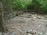
The stone ruins at the bay date from 1844. In 1977, Kenneth McIntyre
suggested the ruins were of Portuguese origin, and this romantic notion quickly established credence before it was ultimately proven incorrect by historian Michael Pearson.
were left to be collected, until a passable road was built.
Bittangabee Bay is the nearest safe anchorage to Green Cape Lighthouse , built in 1881, and it is where the building materials and supplies for the lighthouse were landed, and then carted overland to the lighthouse. A wooden jetty and storeroom were built at Bittangabee Bay in 1881 by Albert Aspinall
, a stonemason and builder, who won the contract to build the lighthouse. Aspinall then took five months to construct a seven kilometre-long wooden tramway through the forest and heathland to connect Bittangabee with Green Cape
, when he could then commence building the light tower and houses. Materials and supplies were transported Bittangabee to the lighthouse site on wooden trolleys pulled by horses.
Bay
A bay is an area of water mostly surrounded by land. Bays generally have calmer waters than the surrounding sea, due to the surrounding land blocking some waves and often reducing winds. Bays also exist as an inlet in a lake or pond. A large bay may be called a gulf, a sea, a sound, or a bight...
on the rugged and remote stretch of coastline south of Eden, New South Wales
Eden, New South Wales
Eden is a coastal town in the South Coast region of New South Wales, Australia. The town, south of the state capital Sydney near the border with Victoria, is located between Nullica Bay to the south and Calle Calle Bay, the northern reach of Twofold Bay, and built on undulating land adjacent to a...
in New South Wales
New South Wales
New South Wales is a state of :Australia, located in the east of the country. It is bordered by Queensland, Victoria and South Australia to the north, south and west respectively. To the east, the state is bordered by the Tasman Sea, which forms part of the Pacific Ocean. New South Wales...
(Australia
Australia
Australia , officially the Commonwealth of Australia, is a country in the Southern Hemisphere comprising the mainland of the Australian continent, the island of Tasmania, and numerous smaller islands in the Indian and Pacific Oceans. It is the world's sixth-largest country by total area...
). The bay is located in Ben Boyd National Park
Ben Boyd National Park
Ben Boyd National Park is a national park in New South Wales, Australia, south of Sydney. It is named after the entrepreneur Ben Boyd who had a variety of interests in the far South Coast of New South Wales including whaling and farming. The park itself was established in 1971...
, with a small camping ground and facilities maintained by
National Parks and Wildlife Service (NPWS)
National Parks and Wildlife Service (New South Wales)
The National Parks and Wildlife Service is part of the Office of Environment and Heritage - the main government conservation agency in New South Wales, Australia....
, Merimbula office . It can be reached by an unsealed road from the Princes Highway. The bay is the only safe haven between Twofold Bay
Twofold Bay
Twofold Bay is a bay on the south coast of New South Wales, Australia, close to the border with Victoria. The bay has an area of about 30 square kilometres. Close to North Head is a conspicuous islet, Mewstone Rock. About five km south of the islet is Red Point which forms the southern headland of...
, Eden, New South Wales
Eden, New South Wales
Eden is a coastal town in the South Coast region of New South Wales, Australia. The town, south of the state capital Sydney near the border with Victoria, is located between Nullica Bay to the south and Calle Calle Bay, the northern reach of Twofold Bay, and built on undulating land adjacent to a...
and Mallacoota Inlet and passing yachts are seen anchored for the night there most evenings. It is fed by Bittangabee Creek.
History
.
Bittangabee Bay was known as 'Pertangerbee' by the original occupants of the area, the Thaua/Thawa/Thauaira people of the Yuin
Yuin
Yuin people are those Australian Aborigines from the South Coast of New South wales who are considered to be the traditional owners of the land and water from Merimbula to Port Jackson.- Country :...
(Murring) nation, who have lived here for over 6,000 years. It was an important camp place and teaching ground, possibly a men's area, as Bundooro, one of the aboriginal names for Green Cape
Green Cape
Green Cape is a headland or cape on the far south coast of New South Wales. It is located at 37° 15' S 150° 03' E, within Ben Boyd National Park, south of Eden, New South Wales...
, was a teaching area for young men, and believed to be a men's area . Naa-chi (now Nadgee Nature Reserve
Nadgee Nature Reserve
Nadgee Nature Reserve is a protected area on the far south coast of New South Wales, to the immediate south of Ben Boyd National Park. Its southern border is the state border with Victoria, where it abuts Croajingolong National Park. Of its total area of , is declared wilderness...
), on the other side of Green Cape
Green Cape
Green Cape is a headland or cape on the far south coast of New South Wales. It is located at 37° 15' S 150° 03' E, within Ben Boyd National Park, south of Eden, New South Wales...
to Bittangabee Bay, is the resting-place of their Rainbow Serpent
Rainbow Serpent
The Rainbow Serpent is a common motif in the art and mythology of Aboriginal Australia. It is named for the snake-like meandering of water across a landscape and the colour spectrum caused when sunlight strikes water at an appropriate angle relative to the observer.The Rainbow Serpent is seen as...
, the most important totem of most Australian aboriginal people.
The Aborigines retain strong traditional and spiritual links to the land, and people in the National Parks Service wish to maintain a collaborative relationship with Koori
Koori
The Koori are the indigenous Australians that traditionally occupied modern day New South Wales and Victoria....
people, acknowledging their cultural beliefs and themselves adopting a philosophy of custodianship of this beautiful part of NSW.
The stone ruins at the bay date from 1844. In 1977, Kenneth McIntyre
Kenneth McIntyre
Kenneth Gordon McIntyre OBE was an Australian lawyer, historian and mathematician who is perhaps best known for his controversial book The Secret Discovery of Australia - Portuguese ventures 200 years before Captain Cook....
suggested the ruins were of Portuguese origin, and this romantic notion quickly established credence before it was ultimately proven incorrect by historian Michael Pearson.
Green Cape Lighthouse
The derelict stone storehouse at Bittangabee Bay is the only standing building within 6 kilometres (from the lighthouse and beach houses at Wonboyn), and was where supplies for Green Cape LighthouseGreen Cape Lighthouse
The Green Cape Lighthouse is a lighthouse located at the tip of Green Cape, a headland forming the northern boundary of Disaster Bay, in southern New South Wales, Australia. It is the southernmost lighthouse in New South Wales and Australia's first lighthouse built in concrete. At it is also the...
were left to be collected, until a passable road was built.
Bittangabee Bay is the nearest safe anchorage to Green Cape Lighthouse , built in 1881, and it is where the building materials and supplies for the lighthouse were landed, and then carted overland to the lighthouse. A wooden jetty and storeroom were built at Bittangabee Bay in 1881 by Albert Aspinall
Albert Aspinall
Albert Wood Aspinall was an Australian stonemason and builder. He was an expert in constructing round towers and buildings.-Early life:...
, a stonemason and builder, who won the contract to build the lighthouse. Aspinall then took five months to construct a seven kilometre-long wooden tramway through the forest and heathland to connect Bittangabee with Green Cape
Green Cape
Green Cape is a headland or cape on the far south coast of New South Wales. It is located at 37° 15' S 150° 03' E, within Ben Boyd National Park, south of Eden, New South Wales...
, when he could then commence building the light tower and houses. Materials and supplies were transported Bittangabee to the lighthouse site on wooden trolleys pulled by horses.