

Dieppe maps
Encyclopedia
The Dieppe maps are a series of world maps produced in Dieppe
, France, in the 1540s, 1550s and 1560s. They are large hand-produced maps, commissioned for wealthy and royal patrons, including Henry II of France
and Henry VIII of England
. The Dieppe school of cartographers
included Pierre Desceliers
, Johne Rotz, Guillaume Le Testu
, Guillaume Brouscon
and Nicholas Desliens.
 The Dieppe Maps known to have existed into modern times include the following
Sarah Toulouse has published a more detailed and comprehensive list of 37 charts and atlases made between 1542 and 1635 and belonging to the Dieppe or Norman school of marine cartography.
, Portuguese
or Gallicised Portuguese, it has often been assumed that the Dieppe school of mapmakers were working from Portuguese
sources that no longer exist. It has been assumed that Portuguese
cartographers
were bribed for information of the latest discoveries, despite the official Portuguese
Politica de sigilo (policy of silence). The Cantino
map of 1502 (not a Dieppe school map) shows evidence of second hand Portuguese
sources, and this has been taken by some as supporting evidence for this assumption.
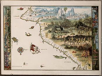
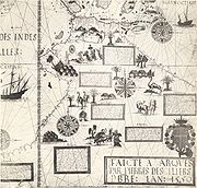
A common feature of most of the Dieppe world maps (see Vallard 1547, Desceliers 1550) are the compass rose
s and navigational rhumb lines, suggestive of a sea-chart
. However, they are best understood as works of art, clearly intended to be spread out on a table, and containing information on the latest discoveries, side by side with mythological references and illustrations. For example, the Desceliers 1550 map carries descriptions of early French
attempts to colonise Canada
, the conquests of Peru
by the Spanish
and the Portuguese
sea-trade among the Spice Islands
. On the same map can be found descriptions of legendary Cathay
, king Prester John
in Ethiopia
, and the race of Amazons
in Russia. Other Dieppe maps also carry fictitious features such as the Marco Polo
inspired Zanzibar/Îles des Geanz. (see Vallard 1547, Rotz 1542 and Dauphin c1536-42). As with other maps made before the 17th century, the Dieppe maps show no knowledge of longitude
. While latitude
could be marked in degrees as observed by astrolabe
or quadrant
, easting could only be given in distance. Mercator's
projection first appeared in 1568-9, a development too late to influence the Dieppe cartographers
.
Most of the Dieppe maps depict a large land mass entitled Jave la Grande
, between what is now Indonesia
and Antarctica. In the English-speaking world particularly, academic and popular interest in the Dieppe maps over the last 150 years has focused largely on this feature of the maps. This is because Jave la Grande is thought by some writers to provide clues of a possible Portuguese
exploration of Australia's coasts in the 1520s. However, the most recent academic writings on the Dieppe maps by Carile(1997), Brunelle (2007) and King (2009) have suggested the maps need to be considered in their entirety, and consideration needs to be given to what they reveal about various influences on the mapmakers, as well as French aspirations. This group of writers argue that the maps are not necessarily literal records of voyages of exploration.
has argued that, although the Dieppe school of cartographers was active for only a generation—from about 1535 to 1562—the cartographers associated with it were acting as propagandists for French geographic knowledge and territorial claims in the New World
. The decades when the Dieppe school was flourishing were also the decades in which French trade with the New World
was at its 16th century height, in terms of the North Atlantic fish trade, the still fledgling fur trade, and, most important for the cartographers, the rivalry with the Portuguese
for control of the coasts of Brazil
and the supplies of lucrative Brazilwood
. Brunelle says that the Dieppe cartographers accessed cartographic skills and geographic knowledge from Portuguese
mariners, pilots, and geographers working in France, at the same time as they were producing maps meant to emphasize French dominion over the New World
, both in Newfoundland and in Brazil
, that the Portuguese
also claimed. She noted that, in design and decorative style the Dieppe school maps represented a blending of the latest geographical and nautical knowledge circulating in Europe (and the portolan style of depicting coastlines), with older conceptualizations of world geography deriving from Ptolemy
and mediaeval cartographers and explorers such as Marco Polo
. Renaissance
mapmakers such as those based in Dieppe relied heavily on each other's work, as well as on maps from previous generations, and thus their maps represented a mixture of old and new data and even differing conceptualizations of space, often coexisting uneasily in the same map.
, incorporating a huge promontory extending northward called "Jave la Grande". According to the French geographer Numa Broc, Terra Australis
found its most inspired illustrator in pilot-cartographer of Le Havre
, Guillaume Le Testu
. Le Testu's
Cosmographie Universelle, the sumptuous atlas he presented in 1556 to Coligny
, Grand Admiral of France, constituted a veritable encyclopaedia of the geographic and ethnographic knowledge of the time. French historian Frank Lestringant has said: "The nautical fiction of Le Testu fulfilled the conditions of a technical instrumentality, while giving to King Henry II
and his minister, Admiral Coligny
, the… anticipatory image of an empire that awaited to be brought into being". In the Cosmographie twelve vividly coloured charts are devoted to a survey of the fictitious continent Terra Australis
. In these charts, Le Testu
drew the outlines of an enormous Austral continent which covered the southern part of the globe and filled a considerable part of the Indian Ocean
. This imaginary land derived from the Antichthone of the Greeks and had already been reactivated, notably by the mathematician and cosmographer Oronce Fine
(1531) and by Le Testu's
predecessors of the Dieppe school. According to the Portuguese historian Paolo Carile, the attitude of Le Testu
reveals a cultural conflict between the old cosmographic beliefs and the demands of an empirical concept of geographical and ethnographical knowledge, influenced by the rigour of his Calvinist faith. Carile notes that while on the iconographic side Le Testu
depicts an Austral Continent with strangely tropical conditions incorporating beasts drawn from fantasy and old legends, on the other side he nullifies these leaps of imagination by his admission that the land shown as part of the Terra Australis
was still unknown and what was marked out on his map was based solely on imagination and surmise.
, the first Professor of Mathematics at the Collège Royal in Paris (now the Collège de France). His 1531 world map was published in 1532 in the Novus Orbis Regionum ac Insularum. Fine’s cosmography was derived from that of the German mathematician, Johannes Schoener. In his study of Schöner‘s globes, Franz von Wieser, found that the derivation of Fine’s mappemonde from them was “unverkennbar” (“unmistakeable”). Lucien Gallois noted in 1890, as Franz von Wieser had done before him, the undeniable “ressemblance parfaite” (“perfect resemblance”) between Fine’s 1531 mappemonde and Schoener’s 1533 globe. Schoener’s globe of 1523 also closely resembled Fine’s mappemonde, proving that Schoener's cosmographic concepts pre-dated those of Fine. Albert Anthiaume wrote in 1911:
One place name in particular on the Dieppe maps, the baie bresille on northwest coast the 1542 Rotz map’s Lande of Java, which appears as Baye bresille on the Harleian, Baye bresill on the Desceliers and Baie Braecillie on Le Testu’s Grande Jave of 1556, illustrates the reliance of their makers on the Schoener/Fine cosmography. Armand Rainaud noted in 1893 that this appellation, “without doubt comes from the globes of Schoener and the maps of Oronce Fine”. On Fine’s 1531 mappemonde, BRASIELIE REGIO is shown as part of the Terra Australis lying to the east of Africa and to the south of Java, just where Schoener located BRASIELIE REGIO on his 1523 globe, and where the Dieppe maps locate their Baye Bresille.
Another indication of this reliance is given by the placement of CATIGARA (Kattigara) on the western coast of South America on the mid-1540s Harleian mappemonde and on Le Testu’s 1556 map of western South America: the same location it occupied on Fine’s 1531 mappemonde and on Schoener’s 1523 and 1533 globes. Kattigara (or Cattigara) was understood by the 2nd century Alexandrian geographer Claudius Ptolemy to be a port and emporium on the eastern side of the Sinus Magnus, or Great Gulf, the actual Gulf of Thailand. The 1507 Waldseemüller map
shows Catigara in this location. Following the 1519-1521 circumnavigation of the world by the expedition led by Ferdinand Magellan
and completed after his death in the Philippines by Sebastian de Juan Sebastián Elcano
, Schoener identified the Pacific Ocean with Ptolemy’s Sinus Magnus, which he labelled on his 1523 globe, SINUS MAGNUS EOV[um] MARE DE SUR (the Great Gulf, Eastern Sea, South Sea”). The eastern side of the Sinus Magnus, which Schoener took to be the peninsula of India Superior (Indochina) where Cattigara was located, was therefore identified by him with South America, which on his 1533 globe bears the inscription, America, Indiae superioris et Asiae continentis pars (“America, a part of India Superior and of the Asian continent”). Cattigara was accordingly located on Schoener’s 1523 and 1533 globes on the western coast of South America. CATIGARA occupied the same location on Fine’s mappemonde, as it also did on the Dieppe school maps, the mid-1540s Harleian mappemonde and Le Testu’s 1556 map of western South America.
in the mid-16th century is indicated by Lancelot Voisin de La Popelinière
, who in 1582 published Les Trois Mondes, a work setting out the history of the discovery of the globe. In Les Trois Mondes, La Popelinière pursued a geopolitical design by using cosmographic conjectures which were at the time quite credible, to theorize a colonial expansion by France into the Austral territories. His country, eliminated from colonial competition in the New World
after a series of checks at the hands of the Portuguese and Spanish, could only thenceforward orient her expansion toward this "third world". He declared: "to the ambition of the French is promised the Terre Australe
, a territory which could not but be filled with all kinds of goods and things of excellence". Taking up an earlier proposal by André d'Albaigne
and inspired by Le Testu's
description of Terra Australis
, La Popelinière described in eloquent terms this unknown "third world" which would complete the Old World
and the New World
. He wrote;
It is noteworthy that La Popelinière believed that only Ferdinand Magellan
had actually sighted the southern continent, in the shape of Tierra del Fuego
. He was apparently ignorant that Francis Drake
sailed through open sea to the south of Tierra del Fuego
in 1578, proving it to be an island and not, as Magellan
had supposed, part of Terra Australis
. La Popelinière, the would be colonist, gave no indication that he thought that anyone, French, Portuguese
or otherwise, had visited the part of Terra Australis
shown on the Dieppe maps as "Jave la Grande".
 Discussion of the Dieppe maps in contemporary Australia is exclusively confined to the Jave la Grande
feature. In the media, the maps are sometimes mistakenly described as Portuguese and they are often cited as evidence James Cook did not "discover Australia".
The first writer to put these maps forward as evidence of Portuguese
discovery of Australia was Alexander Dalrymple
in 1786, in a short note to his Memoir Concerning the Chagos and Adjacent Islands. Dalrymple
was intrigued enough to publish 200 copies of the Dauphin map.
Since then a number of other writers have contributed to the debate about the "Jave La Grande" landmass that appears on the Dieppe maps. These include;
Dieppe, Seine-Maritime
Dieppe is a commune in the Seine-Maritime department in France. In 1999, the population of the whole Dieppe urban area was 81,419.A port on the English Channel, famous for its scallops, and with a regular ferry service from the Gare Maritime to Newhaven in England, Dieppe also has a popular pebbled...
, France, in the 1540s, 1550s and 1560s. They are large hand-produced maps, commissioned for wealthy and royal patrons, including Henry II of France
Henry II of France
Henry II was King of France from 31 March 1547 until his death in 1559.-Early years:Henry was born in the royal Château de Saint-Germain-en-Laye, near Paris, the son of Francis I and Claude, Duchess of Brittany .His father was captured at the Battle of Pavia in 1525 by his sworn enemy,...
and Henry VIII of England
Henry VIII of England
Henry VIII was King of England from 21 April 1509 until his death. He was Lord, and later King, of Ireland, as well as continuing the nominal claim by the English monarchs to the Kingdom of France...
. The Dieppe school of cartographers
Cartography
Cartography is the study and practice of making maps. Combining science, aesthetics, and technique, cartography builds on the premise that reality can be modeled in ways that communicate spatial information effectively.The fundamental problems of traditional cartography are to:*Set the map's...
included Pierre Desceliers
Pierre Desceliers
Pierre Desceliers was a French cartographer of the Renaissance and an eminent member of the Dieppe School of Cartography. He is considered the father of French hydrography....
, Johne Rotz, Guillaume Le Testu
Guillaume Le Testu
Guillaume Le Testu, also called Têtu, was a 16th century French corsair, explorer and navigator during the Elizabethan age. He was a successful privateer during the early years of the French Wars of Religion...
, Guillaume Brouscon
Guillaume Brouscon
Guillaume Brouscon was a French mapmaker of the Dieppe school in the 16th century. He was from the port of Le Conquet, near BrestHe published his Brouscon's Almanachs in 1546, which were used for their informations on tides by English, French and Breton sailors. They allowed to known the direction...
and Nicholas Desliens.
Existing Dieppe maps
- Johne Rotz, Boke of Idrography, 1542. British LibraryBritish LibraryThe British Library is the national library of the United Kingdom, and is the world's largest library in terms of total number of items. The library is a major research library, holding over 150 million items from every country in the world, in virtually all known languages and in many formats,...
, London - Guillaume BrousconGuillaume BrousconGuillaume Brouscon was a French mapmaker of the Dieppe school in the 16th century. He was from the port of Le Conquet, near BrestHe published his Brouscon's Almanachs in 1546, which were used for their informations on tides by English, French and Breton sailors. They allowed to known the direction...
, world chart, 1543, Huntington Library, Los Angeles, California - Pierre DesceliersPierre DesceliersPierre Desceliers was a French cartographer of the Renaissance and an eminent member of the Dieppe School of Cartography. He is considered the father of French hydrography....
, "Royal" world chart, 1546. John Rylands LibraryJohn Rylands LibraryThe John Rylands Library is a Victorian Gothic building on Deansgate in Manchester, England. The library, which opened to the public in 1900, was founded by Mrs Enriqueta Augustina Rylands in memory of her late husband, John Rylands...
, University of ManchesterUniversity of ManchesterThe University of Manchester is a public research university located in Manchester, United Kingdom. It is a "red brick" university and a member of the Russell Group of research-intensive British universities and the N8 Group... - Anonymous, "Harleian" or "Dauphin" world chart. c1547. British LibraryBritish LibraryThe British Library is the national library of the United Kingdom, and is the world's largest library in terms of total number of items. The library is a major research library, holding over 150 million items from every country in the world, in virtually all known languages and in many formats,...
, London - Anonymous, made for Nicholas Vallard, portolan atlas, c1547. Huntington Library, Los Angeles, California
- Pierre Desceliers, world chart, 1550. British LibraryBritish LibraryThe British Library is the national library of the United Kingdom, and is the world's largest library in terms of total number of items. The library is a major research library, holding over 150 million items from every country in the world, in virtually all known languages and in many formats,...
, London - Pierre Desceliers, world chart, 1553. ViennaViennaVienna is the capital and largest city of the Republic of Austria and one of the nine states of Austria. Vienna is Austria's primary city, with a population of about 1.723 million , and is by far the largest city in Austria, as well as its cultural, economic, and political centre...
(Destroyed) - Guillaume Le Testu, Cosmographie Universelle, 1555. Bibliothèque du Service historique de l‘Armée de Terre, Paris
- Anonymous, portolan atlas -attributed to Pierre Desceliers, world chart. c1555. Morgan LibraryMorgan LibraryThe Morgan Library & Museum is a museum and research library in New York City, USA. It was founded to house the private library of J. P. Morgan in 1906, which included, besides the manuscripts and printed books, some of them in rare bindings, his collection of prints and drawings...
, New YorkNew YorkNew York is a state in the Northeastern region of the United States. It is the nation's third most populous state. New York is bordered by New Jersey and Pennsylvania to the south, and by Connecticut, Massachusetts and Vermont to the east... - Guillaume Le Testu, world chart, 1566. Bibliothèque Nationale de FranceBibliothèque nationale de FranceThe is the National Library of France, located in Paris. It is intended to be the repository of all that is published in France. The current president of the library is Bruno Racine.-History:...
, Paris - Nicholas Desliens, world chart, c1541-1561. DresdenDresdenDresden is the capital city of the Free State of Saxony in Germany. It is situated in a valley on the River Elbe, near the Czech border. The Dresden conurbation is part of the Saxon Triangle metropolitan area....
(Destroyed) - Nicholas Desliens, world chart, 1566. Bibliothèque Nationale de FranceBibliothèque nationale de FranceThe is the National Library of France, located in Paris. It is intended to be the repository of all that is published in France. The current president of the library is Bruno Racine.-History:...
, Paris - Nicholas Desliens, world chart, 1567. National Maritime MuseumNational Maritime MuseumThe National Maritime Museum in Greenwich, England is the leading maritime museum of the United Kingdom and may be the largest museum of its kind in the world. The historic buildings forming part of the Maritime Greenwich World Heritage Site, it also incorporates the Royal Observatory, Greenwich,...
, GreenwichGreenwichGreenwich is a district of south London, England, located in the London Borough of Greenwich.Greenwich is best known for its maritime history and for giving its name to the Greenwich Meridian and Greenwich Mean Time... - Attributed to Nicholas Desliens, world chart, c1568. National Maritime MuseumNational Maritime MuseumThe National Maritime Museum in Greenwich, England is the leading maritime museum of the United Kingdom and may be the largest museum of its kind in the world. The historic buildings forming part of the Maritime Greenwich World Heritage Site, it also incorporates the Royal Observatory, Greenwich,...
, GreenwichGreenwichGreenwich is a district of south London, England, located in the London Borough of Greenwich.Greenwich is best known for its maritime history and for giving its name to the Greenwich Meridian and Greenwich Mean Time...
Sarah Toulouse has published a more detailed and comprehensive list of 37 charts and atlases made between 1542 and 1635 and belonging to the Dieppe or Norman school of marine cartography.
The Dieppe School of mapmaking
Because many of the inscriptions on the Dieppe maps are written in FrenchFrench language
French is a Romance language spoken as a first language in France, the Romandy region in Switzerland, Wallonia and Brussels in Belgium, Monaco, the regions of Quebec and Acadia in Canada, and by various communities elsewhere. Second-language speakers of French are distributed throughout many parts...
, Portuguese
Portuguese language
Portuguese is a Romance language that arose in the medieval Kingdom of Galicia, nowadays Galicia and Northern Portugal. The southern part of the Kingdom of Galicia became independent as the County of Portugal in 1095...
or Gallicised Portuguese, it has often been assumed that the Dieppe school of mapmakers were working from Portuguese
History of Portugal
The history of Portugal, a European and an Atlantic nation, dates back to the Early Middle Ages. In the 15th and 16th centuries, it ascended to the status of a world power during Europe's "Age of Discovery" as it built up a vast empire including possessions in South America, Africa, Asia and...
sources that no longer exist. It has been assumed that Portuguese
History of Portugal
The history of Portugal, a European and an Atlantic nation, dates back to the Early Middle Ages. In the 15th and 16th centuries, it ascended to the status of a world power during Europe's "Age of Discovery" as it built up a vast empire including possessions in South America, Africa, Asia and...
cartographers
Cartography
Cartography is the study and practice of making maps. Combining science, aesthetics, and technique, cartography builds on the premise that reality can be modeled in ways that communicate spatial information effectively.The fundamental problems of traditional cartography are to:*Set the map's...
were bribed for information of the latest discoveries, despite the official Portuguese
History of Portugal
The history of Portugal, a European and an Atlantic nation, dates back to the Early Middle Ages. In the 15th and 16th centuries, it ascended to the status of a world power during Europe's "Age of Discovery" as it built up a vast empire including possessions in South America, Africa, Asia and...
Politica de sigilo (policy of silence). The Cantino
Cantino planisphere
The Cantino planisphere is the earliest surviving map showing Portuguese Discoveries in the east and west. It is named after Alberto Cantino, an agent for the Duke of Ferrara, who successfully smuggled it from Portugal to Italy in 1502...
map of 1502 (not a Dieppe school map) shows evidence of second hand Portuguese
History of Portugal
The history of Portugal, a European and an Atlantic nation, dates back to the Early Middle Ages. In the 15th and 16th centuries, it ascended to the status of a world power during Europe's "Age of Discovery" as it built up a vast empire including possessions in South America, Africa, Asia and...
sources, and this has been taken by some as supporting evidence for this assumption.
A common feature of most of the Dieppe world maps (see Vallard 1547, Desceliers 1550) are the compass rose
Compass rose
A compass rose, sometimes called a windrose, is a figure on a compass, map, nautical chart or monument used to display the orientation of the cardinal directions — North, East, South and West - and their intermediate points. It is also the term for the graduated markings found on the traditional...
s and navigational rhumb lines, suggestive of a sea-chart
Nautical chart
A nautical chart is a graphic representation of a maritime area and adjacent coastal regions. Depending on the scale of the chart, it may show depths of water and heights of land , natural features of the seabed, details of the coastline, navigational hazards, locations of natural and man-made aids...
. However, they are best understood as works of art, clearly intended to be spread out on a table, and containing information on the latest discoveries, side by side with mythological references and illustrations. For example, the Desceliers 1550 map carries descriptions of early French
History of France
The history of France goes back to the arrival of the earliest human being in what is now France. Members of the genus Homo entered the area hundreds of thousands years ago, while the first modern Homo sapiens, the Cro-Magnons, arrived around 40,000 years ago...
attempts to colonise Canada
History of Canada
The history of Canada covers the period from the arrival of Paleo-Indians thousands of years ago to the present day. Canada has been inhabited for millennia by distinctive groups of Aboriginal peoples, among whom evolved trade networks, spiritual beliefs, and social hierarchies...
, the conquests of Peru
Peru
Peru , officially the Republic of Peru , is a country in western South America. It is bordered on the north by Ecuador and Colombia, on the east by Brazil, on the southeast by Bolivia, on the south by Chile, and on the west by the Pacific Ocean....
by the Spanish
History of Spain
The history of Spain involves all the other peoples and nations within the Iberian peninsula formerly known as Hispania, and includes still today the nations of Andorra, Gibraltar, Portugal and Spain...
and the Portuguese
History of Portugal
The history of Portugal, a European and an Atlantic nation, dates back to the Early Middle Ages. In the 15th and 16th centuries, it ascended to the status of a world power during Europe's "Age of Discovery" as it built up a vast empire including possessions in South America, Africa, Asia and...
sea-trade among the Spice Islands
Maluku Islands
The Maluku Islands are an archipelago that is part of Indonesia, and part of the larger Maritime Southeast Asia region. Tectonically they are located on the Halmahera Plate within the Molucca Sea Collision Zone...
. On the same map can be found descriptions of legendary Cathay
Cathay
Cathay is the Anglicized version of "Catai" and an alternative name for China in English. It originates from the word Khitan, the name of a nomadic people who founded the Liao Dynasty which ruled much of Northern China from 907 to 1125, and who had a state of their own centered around today's...
, king Prester John
Prester John
The legends of Prester John were popular in Europe from the 12th through the 17th centuries, and told of a Christian patriarch and king said to rule over a Christian nation lost amidst the Muslims and pagans in the Orient. Written accounts of this kingdom are variegated collections of medieval...
in Ethiopia
Ethiopia
Ethiopia , officially known as the Federal Democratic Republic of Ethiopia, is a country located in the Horn of Africa. It is the second-most populous nation in Africa, with over 82 million inhabitants, and the tenth-largest by area, occupying 1,100,000 km2...
, and the race of Amazons
Amazons
The Amazons are a nation of all-female warriors in Greek mythology and Classical antiquity. Herodotus placed them in a region bordering Scythia in Sarmatia...
in Russia. Other Dieppe maps also carry fictitious features such as the Marco Polo
Marco Polo
Marco Polo was a Venetian merchant traveler from the Venetian Republic whose travels are recorded in Il Milione, a book which did much to introduce Europeans to Central Asia and China. He learned about trading whilst his father and uncle, Niccolò and Maffeo, travelled through Asia and apparently...
inspired Zanzibar/Îles des Geanz. (see Vallard 1547, Rotz 1542 and Dauphin c1536-42). As with other maps made before the 17th century, the Dieppe maps show no knowledge of longitude
Longitude
Longitude is a geographic coordinate that specifies the east-west position of a point on the Earth's surface. It is an angular measurement, usually expressed in degrees, minutes and seconds, and denoted by the Greek letter lambda ....
. While latitude
Latitude
In geography, the latitude of a location on the Earth is the angular distance of that location south or north of the Equator. The latitude is an angle, and is usually measured in degrees . The equator has a latitude of 0°, the North pole has a latitude of 90° north , and the South pole has a...
could be marked in degrees as observed by astrolabe
Astrolabe
An astrolabe is an elaborate inclinometer, historically used by astronomers, navigators, and astrologers. Its many uses include locating and predicting the positions of the Sun, Moon, planets, and stars, determining local time given local latitude and longitude, surveying, triangulation, and to...
or quadrant
Quadrant (instrument)
A quadrant is an instrument that is used to measure angles up to 90°. It was originally proposed by Ptolemy as a better kind of astrolabe. Several different variations of the instrument were later produced by medieval Muslim astronomers.-Types of quadrants:...
, easting could only be given in distance. Mercator's
Gerardus Mercator
thumb|right|200px|Gerardus MercatorGerardus Mercator was a cartographer, born in Rupelmonde in the Hapsburg County of Flanders, part of the Holy Roman Empire. He is remembered for the Mercator projection world map, which is named after him...
projection first appeared in 1568-9, a development too late to influence the Dieppe cartographers
Cartography
Cartography is the study and practice of making maps. Combining science, aesthetics, and technique, cartography builds on the premise that reality can be modeled in ways that communicate spatial information effectively.The fundamental problems of traditional cartography are to:*Set the map's...
.
Most of the Dieppe maps depict a large land mass entitled Jave la Grande
Jave la Grande
La grande isle de Java was, according to Marco Polo, the largest island in the world: his Java Minor was the actual island of Sumatra, which takes its name from the city of Samudera situated on its northern coast....
, between what is now Indonesia
Indonesia
Indonesia , officially the Republic of Indonesia , is a country in Southeast Asia and Oceania. Indonesia is an archipelago comprising approximately 13,000 islands. It has 33 provinces with over 238 million people, and is the world's fourth most populous country. Indonesia is a republic, with an...
and Antarctica. In the English-speaking world particularly, academic and popular interest in the Dieppe maps over the last 150 years has focused largely on this feature of the maps. This is because Jave la Grande is thought by some writers to provide clues of a possible Portuguese
History of Portugal
The history of Portugal, a European and an Atlantic nation, dates back to the Early Middle Ages. In the 15th and 16th centuries, it ascended to the status of a world power during Europe's "Age of Discovery" as it built up a vast empire including possessions in South America, Africa, Asia and...
exploration of Australia's coasts in the 1520s. However, the most recent academic writings on the Dieppe maps by Carile(1997), Brunelle (2007) and King (2009) have suggested the maps need to be considered in their entirety, and consideration needs to be given to what they reveal about various influences on the mapmakers, as well as French aspirations. This group of writers argue that the maps are not necessarily literal records of voyages of exploration.
Gayle K. Brunelle's work
Professor Gayle K. Brunelle of California State UniversityCalifornia State University
The California State University is a public university system in the state of California. It is one of three public higher education systems in the state, the other two being the University of California system and the California Community College system. It is incorporated as The Trustees of the...
has argued that, although the Dieppe school of cartographers was active for only a generation—from about 1535 to 1562—the cartographers associated with it were acting as propagandists for French geographic knowledge and territorial claims in the New World
New World
The New World is one of the names used for the Western Hemisphere, specifically America and sometimes Oceania . The term originated in the late 15th century, when America had been recently discovered by European explorers, expanding the geographical horizon of the people of the European middle...
. The decades when the Dieppe school was flourishing were also the decades in which French trade with the New World
New World
The New World is one of the names used for the Western Hemisphere, specifically America and sometimes Oceania . The term originated in the late 15th century, when America had been recently discovered by European explorers, expanding the geographical horizon of the people of the European middle...
was at its 16th century height, in terms of the North Atlantic fish trade, the still fledgling fur trade, and, most important for the cartographers, the rivalry with the Portuguese
Portugal
Portugal , officially the Portuguese Republic is a country situated in southwestern Europe on the Iberian Peninsula. Portugal is the westernmost country of Europe, and is bordered by the Atlantic Ocean to the West and South and by Spain to the North and East. The Atlantic archipelagos of the...
for control of the coasts of Brazil
Brazil
Brazil , officially the Federative Republic of Brazil , is the largest country in South America. It is the world's fifth largest country, both by geographical area and by population with over 192 million people...
and the supplies of lucrative Brazilwood
Brazilwood
Caesalpinia echinata is a species of Brazilian timber tree in the pea family, Fabaceae. Common names include Brazilwood, Pau-Brasil, Pau de Pernambuco and Ibirapitanga . This plant has a dense, orange-red heartwood that takes a high shine, and it is the premier wood used for making bows for...
. Brunelle says that the Dieppe cartographers accessed cartographic skills and geographic knowledge from Portuguese
Portugal
Portugal , officially the Portuguese Republic is a country situated in southwestern Europe on the Iberian Peninsula. Portugal is the westernmost country of Europe, and is bordered by the Atlantic Ocean to the West and South and by Spain to the North and East. The Atlantic archipelagos of the...
mariners, pilots, and geographers working in France, at the same time as they were producing maps meant to emphasize French dominion over the New World
New World
The New World is one of the names used for the Western Hemisphere, specifically America and sometimes Oceania . The term originated in the late 15th century, when America had been recently discovered by European explorers, expanding the geographical horizon of the people of the European middle...
, both in Newfoundland and in Brazil
Brazil
Brazil , officially the Federative Republic of Brazil , is the largest country in South America. It is the world's fifth largest country, both by geographical area and by population with over 192 million people...
, that the Portuguese
Portugal
Portugal , officially the Portuguese Republic is a country situated in southwestern Europe on the Iberian Peninsula. Portugal is the westernmost country of Europe, and is bordered by the Atlantic Ocean to the West and South and by Spain to the North and East. The Atlantic archipelagos of the...
also claimed. She noted that, in design and decorative style the Dieppe school maps represented a blending of the latest geographical and nautical knowledge circulating in Europe (and the portolan style of depicting coastlines), with older conceptualizations of world geography deriving from Ptolemy
Ptolemy
Claudius Ptolemy , was a Roman citizen of Egypt who wrote in Greek. He was a mathematician, astronomer, geographer, astrologer, and poet of a single epigram in the Greek Anthology. He lived in Egypt under Roman rule, and is believed to have been born in the town of Ptolemais Hermiou in the...
and mediaeval cartographers and explorers such as Marco Polo
Marco Polo
Marco Polo was a Venetian merchant traveler from the Venetian Republic whose travels are recorded in Il Milione, a book which did much to introduce Europeans to Central Asia and China. He learned about trading whilst his father and uncle, Niccolò and Maffeo, travelled through Asia and apparently...
. Renaissance
Renaissance
The Renaissance was a cultural movement that spanned roughly the 14th to the 17th century, beginning in Italy in the Late Middle Ages and later spreading to the rest of Europe. The term is also used more loosely to refer to the historical era, but since the changes of the Renaissance were not...
mapmakers such as those based in Dieppe relied heavily on each other's work, as well as on maps from previous generations, and thus their maps represented a mixture of old and new data and even differing conceptualizations of space, often coexisting uneasily in the same map.
Other writers on French world views and the Dieppe Maps
The Dieppe maps all depict the southern continent, Terra AustralisTerra Australis
Terra Australis, Terra Australis Ignota or Terra Australis Incognita was a hypothesized continent appearing on European maps from the 15th to the 18th century...
, incorporating a huge promontory extending northward called "Jave la Grande". According to the French geographer Numa Broc, Terra Australis
Terra Australis
Terra Australis, Terra Australis Ignota or Terra Australis Incognita was a hypothesized continent appearing on European maps from the 15th to the 18th century...
found its most inspired illustrator in pilot-cartographer of Le Havre
Le Havre
Le Havre is a city in the Seine-Maritime department of the Haute-Normandie region in France. It is situated in north-western France, on the right bank of the mouth of the river Seine on the English Channel. Le Havre is the most populous commune in the Haute-Normandie region, although the total...
, Guillaume Le Testu
Guillaume Le Testu
Guillaume Le Testu, also called Têtu, was a 16th century French corsair, explorer and navigator during the Elizabethan age. He was a successful privateer during the early years of the French Wars of Religion...
. Le Testu's
Guillaume Le Testu
Guillaume Le Testu, also called Têtu, was a 16th century French corsair, explorer and navigator during the Elizabethan age. He was a successful privateer during the early years of the French Wars of Religion...
Cosmographie Universelle, the sumptuous atlas he presented in 1556 to Coligny
Gaspard de Coligny
Gaspard de Coligny , Seigneur de Châtillon, was a French nobleman and admiral, best remembered as a disciplined Huguenot leader in the French Wars of Religion.-Ancestry:...
, Grand Admiral of France, constituted a veritable encyclopaedia of the geographic and ethnographic knowledge of the time. French historian Frank Lestringant has said: "The nautical fiction of Le Testu fulfilled the conditions of a technical instrumentality, while giving to King Henry II
Henry II of France
Henry II was King of France from 31 March 1547 until his death in 1559.-Early years:Henry was born in the royal Château de Saint-Germain-en-Laye, near Paris, the son of Francis I and Claude, Duchess of Brittany .His father was captured at the Battle of Pavia in 1525 by his sworn enemy,...
and his minister, Admiral Coligny
Gaspard de Coligny
Gaspard de Coligny , Seigneur de Châtillon, was a French nobleman and admiral, best remembered as a disciplined Huguenot leader in the French Wars of Religion.-Ancestry:...
, the… anticipatory image of an empire that awaited to be brought into being". In the Cosmographie twelve vividly coloured charts are devoted to a survey of the fictitious continent Terra Australis
Terra Australis
Terra Australis, Terra Australis Ignota or Terra Australis Incognita was a hypothesized continent appearing on European maps from the 15th to the 18th century...
. In these charts, Le Testu
Guillaume Le Testu
Guillaume Le Testu, also called Têtu, was a 16th century French corsair, explorer and navigator during the Elizabethan age. He was a successful privateer during the early years of the French Wars of Religion...
drew the outlines of an enormous Austral continent which covered the southern part of the globe and filled a considerable part of the Indian Ocean
Indian Ocean
The Indian Ocean is the third largest of the world's oceanic divisions, covering approximately 20% of the water on the Earth's surface. It is bounded on the north by the Indian Subcontinent and Arabian Peninsula ; on the west by eastern Africa; on the east by Indochina, the Sunda Islands, and...
. This imaginary land derived from the Antichthone of the Greeks and had already been reactivated, notably by the mathematician and cosmographer Oronce Fine
Oronce Finé
Oronce Fine was a French mathematician and cartographer.-Life:...
(1531) and by Le Testu's
Guillaume Le Testu
Guillaume Le Testu, also called Têtu, was a 16th century French corsair, explorer and navigator during the Elizabethan age. He was a successful privateer during the early years of the French Wars of Religion...
predecessors of the Dieppe school. According to the Portuguese historian Paolo Carile, the attitude of Le Testu
Guillaume Le Testu
Guillaume Le Testu, also called Têtu, was a 16th century French corsair, explorer and navigator during the Elizabethan age. He was a successful privateer during the early years of the French Wars of Religion...
reveals a cultural conflict between the old cosmographic beliefs and the demands of an empirical concept of geographical and ethnographical knowledge, influenced by the rigour of his Calvinist faith. Carile notes that while on the iconographic side Le Testu
Guillaume Le Testu
Guillaume Le Testu, also called Têtu, was a 16th century French corsair, explorer and navigator during the Elizabethan age. He was a successful privateer during the early years of the French Wars of Religion...
depicts an Austral Continent with strangely tropical conditions incorporating beasts drawn from fantasy and old legends, on the other side he nullifies these leaps of imagination by his admission that the land shown as part of the Terra Australis
Terra Australis
Terra Australis, Terra Australis Ignota or Terra Australis Incognita was a hypothesized continent appearing on European maps from the 15th to the 18th century...
was still unknown and what was marked out on his map was based solely on imagination and surmise.
Dependence of the Dieppe school on the cosmography of Oronce Fine and Johannes Schoener
The cartographers of the Dieppe school incorporated into their world maps the cosmographic concepts of Oronce FineOronce Finé
Oronce Fine was a French mathematician and cartographer.-Life:...
, the first Professor of Mathematics at the Collège Royal in Paris (now the Collège de France). His 1531 world map was published in 1532 in the Novus Orbis Regionum ac Insularum. Fine’s cosmography was derived from that of the German mathematician, Johannes Schoener. In his study of Schöner‘s globes, Franz von Wieser, found that the derivation of Fine’s mappemonde from them was “unverkennbar” (“unmistakeable”). Lucien Gallois noted in 1890, as Franz von Wieser had done before him, the undeniable “ressemblance parfaite” (“perfect resemblance”) between Fine’s 1531 mappemonde and Schoener’s 1533 globe. Schoener’s globe of 1523 also closely resembled Fine’s mappemonde, proving that Schoener's cosmographic concepts pre-dated those of Fine. Albert Anthiaume wrote in 1911:
One place name in particular on the Dieppe maps, the baie bresille on northwest coast the 1542 Rotz map’s Lande of Java, which appears as Baye bresille on the Harleian, Baye bresill on the Desceliers and Baie Braecillie on Le Testu’s Grande Jave of 1556, illustrates the reliance of their makers on the Schoener/Fine cosmography. Armand Rainaud noted in 1893 that this appellation, “without doubt comes from the globes of Schoener and the maps of Oronce Fine”. On Fine’s 1531 mappemonde, BRASIELIE REGIO is shown as part of the Terra Australis lying to the east of Africa and to the south of Java, just where Schoener located BRASIELIE REGIO on his 1523 globe, and where the Dieppe maps locate their Baye Bresille.
Another indication of this reliance is given by the placement of CATIGARA (Kattigara) on the western coast of South America on the mid-1540s Harleian mappemonde and on Le Testu’s 1556 map of western South America: the same location it occupied on Fine’s 1531 mappemonde and on Schoener’s 1523 and 1533 globes. Kattigara (or Cattigara) was understood by the 2nd century Alexandrian geographer Claudius Ptolemy to be a port and emporium on the eastern side of the Sinus Magnus, or Great Gulf, the actual Gulf of Thailand. The 1507 Waldseemüller map
Waldseemüller map
The Waldseemüller map, Universalis Cosmographia, is a printed wall map of the world by German cartographer Martin Waldseemüller, originally published in April 1507. It is known as the first map to use the name "America". The map is drafted on a modification of Ptolemy's second projection, expanded...
shows Catigara in this location. Following the 1519-1521 circumnavigation of the world by the expedition led by Ferdinand Magellan
Ferdinand Magellan
Ferdinand Magellan was a Portuguese explorer. He was born in Sabrosa, in northern Portugal, and served King Charles I of Spain in search of a westward route to the "Spice Islands" ....
and completed after his death in the Philippines by Sebastian de Juan Sebastián Elcano
Juan Sebastián Elcano
Juan Sebastián Elcano was a Basque Spanish explorer who completed the first circumnavigation of the world. As Ferdinand Magellan's second in command, Elcano took over after Magellan's death in the Philippines.-Early life:Elcano was born to Domingo Sebastián Elcano I and Catalina del Puerto...
, Schoener identified the Pacific Ocean with Ptolemy’s Sinus Magnus, which he labelled on his 1523 globe, SINUS MAGNUS EOV[um] MARE DE SUR (the Great Gulf, Eastern Sea, South Sea”). The eastern side of the Sinus Magnus, which Schoener took to be the peninsula of India Superior (Indochina) where Cattigara was located, was therefore identified by him with South America, which on his 1533 globe bears the inscription, America, Indiae superioris et Asiae continentis pars (“America, a part of India Superior and of the Asian continent”). Cattigara was accordingly located on Schoener’s 1523 and 1533 globes on the western coast of South America. CATIGARA occupied the same location on Fine’s mappemonde, as it also did on the Dieppe school maps, the mid-1540s Harleian mappemonde and Le Testu’s 1556 map of western South America.
La Popelinière and French colonial expansion
The extent of French knowledge concerning Terra AustralisTerra Australis
Terra Australis, Terra Australis Ignota or Terra Australis Incognita was a hypothesized continent appearing on European maps from the 15th to the 18th century...
in the mid-16th century is indicated by Lancelot Voisin de La Popelinière
Lancelot Voisin de La Popelinière
Lancelot Voisin de La Popelinière , was a Gascon writer and historian. He was a Protestant, and took part in the Wars of Religion on the Huguenot side...
, who in 1582 published Les Trois Mondes, a work setting out the history of the discovery of the globe. In Les Trois Mondes, La Popelinière pursued a geopolitical design by using cosmographic conjectures which were at the time quite credible, to theorize a colonial expansion by France into the Austral territories. His country, eliminated from colonial competition in the New World
New World
The New World is one of the names used for the Western Hemisphere, specifically America and sometimes Oceania . The term originated in the late 15th century, when America had been recently discovered by European explorers, expanding the geographical horizon of the people of the European middle...
after a series of checks at the hands of the Portuguese and Spanish, could only thenceforward orient her expansion toward this "third world". He declared: "to the ambition of the French is promised the Terre Australe
Terra Australis
Terra Australis, Terra Australis Ignota or Terra Australis Incognita was a hypothesized continent appearing on European maps from the 15th to the 18th century...
, a territory which could not but be filled with all kinds of goods and things of excellence". Taking up an earlier proposal by André d'Albaigne
André d'Albaigne
Francisque and André d’Albaigne were 16th-century Italian merchants from the city of Lucca. Their name was Dalbagnio, according to a notary act of 1567 involving their brother Pellegrino .-d'Albaigne proposal to colonize Terra Australis:-Francisque d’Albaigne :From Lisbon Francisque and André...
and inspired by Le Testu's
Guillaume Le Testu
Guillaume Le Testu, also called Têtu, was a 16th century French corsair, explorer and navigator during the Elizabethan age. He was a successful privateer during the early years of the French Wars of Religion...
description of Terra Australis
Terra Australis
Terra Australis, Terra Australis Ignota or Terra Australis Incognita was a hypothesized continent appearing on European maps from the 15th to the 18th century...
, La Popelinière described in eloquent terms this unknown "third world" which would complete the Old World
Old World
The Old World consists of those parts of the world known to classical antiquity and the European Middle Ages. It is used in the context of, and contrast with, the "New World" ....
and the New World
New World
The New World is one of the names used for the Western Hemisphere, specifically America and sometimes Oceania . The term originated in the late 15th century, when America had been recently discovered by European explorers, expanding the geographical horizon of the people of the European middle...
. He wrote;
It is noteworthy that La Popelinière believed that only Ferdinand Magellan
Ferdinand Magellan
Ferdinand Magellan was a Portuguese explorer. He was born in Sabrosa, in northern Portugal, and served King Charles I of Spain in search of a westward route to the "Spice Islands" ....
had actually sighted the southern continent, in the shape of Tierra del Fuego
Tierra del Fuego
Tierra del Fuego is an archipelago off the southernmost tip of the South American mainland, across the Strait of Magellan. The archipelago consists of a main island Isla Grande de Tierra del Fuego divided between Chile and Argentina with an area of , and a group of smaller islands including Cape...
. He was apparently ignorant that Francis Drake
Francis Drake
Sir Francis Drake, Vice Admiral was an English sea captain, privateer, navigator, slaver, and politician of the Elizabethan era. Elizabeth I of England awarded Drake a knighthood in 1581. He was second-in-command of the English fleet against the Spanish Armada in 1588. He also carried out the...
sailed through open sea to the south of Tierra del Fuego
Tierra del Fuego
Tierra del Fuego is an archipelago off the southernmost tip of the South American mainland, across the Strait of Magellan. The archipelago consists of a main island Isla Grande de Tierra del Fuego divided between Chile and Argentina with an area of , and a group of smaller islands including Cape...
in 1578, proving it to be an island and not, as Magellan
Ferdinand Magellan
Ferdinand Magellan was a Portuguese explorer. He was born in Sabrosa, in northern Portugal, and served King Charles I of Spain in search of a westward route to the "Spice Islands" ....
had supposed, part of Terra Australis
Terra Australis
Terra Australis, Terra Australis Ignota or Terra Australis Incognita was a hypothesized continent appearing on European maps from the 15th to the 18th century...
. La Popelinière, the would be colonist, gave no indication that he thought that anyone, French, Portuguese
Portugal
Portugal , officially the Portuguese Republic is a country situated in southwestern Europe on the Iberian Peninsula. Portugal is the westernmost country of Europe, and is bordered by the Atlantic Ocean to the West and South and by Spain to the North and East. The Atlantic archipelagos of the...
or otherwise, had visited the part of Terra Australis
Terra Australis
Terra Australis, Terra Australis Ignota or Terra Australis Incognita was a hypothesized continent appearing on European maps from the 15th to the 18th century...
shown on the Dieppe maps as "Jave la Grande".
Debates over the theory of Portuguese discovery of Australia
Jave la Grande
La grande isle de Java was, according to Marco Polo, the largest island in the world: his Java Minor was the actual island of Sumatra, which takes its name from the city of Samudera situated on its northern coast....
feature. In the media, the maps are sometimes mistakenly described as Portuguese and they are often cited as evidence James Cook did not "discover Australia".
The first writer to put these maps forward as evidence of Portuguese
History of Portugal
The history of Portugal, a European and an Atlantic nation, dates back to the Early Middle Ages. In the 15th and 16th centuries, it ascended to the status of a world power during Europe's "Age of Discovery" as it built up a vast empire including possessions in South America, Africa, Asia and...
discovery of Australia was Alexander Dalrymple
Alexander Dalrymple
Alexander Dalrymple was a Scottish geographer and the first Hydrographer of the British Admiralty. He was the main proponent of the theory that there existed a vast undiscovered continent in the South Pacific, Terra Australis Incognita...
in 1786, in a short note to his Memoir Concerning the Chagos and Adjacent Islands. Dalrymple
Alexander Dalrymple
Alexander Dalrymple was a Scottish geographer and the first Hydrographer of the British Admiralty. He was the main proponent of the theory that there existed a vast undiscovered continent in the South Pacific, Terra Australis Incognita...
was intrigued enough to publish 200 copies of the Dauphin map.
Since then a number of other writers have contributed to the debate about the "Jave La Grande" landmass that appears on the Dieppe maps. These include;
19th and early 20th century writers
- R. H. Major, in 1859, then Keeper of Maps in the British MuseumBritish MuseumThe British Museum is a museum of human history and culture in London. Its collections, which number more than seven million objects, are amongst the largest and most comprehensive in the world and originate from all continents, illustrating and documenting the story of human culture from its...
, who wrote Early Voyages to Terra Australis, arguing "Java La Grande" was Australia's west and east coastline. - James R. McClymont was of the opinion that the placement of "Jave la Grande" on the Dieppe maps was a theoretical construct and not the result of an actual discovery of Australia. In 1892, he drew attention to the similarity of the "Jave la Grande" of the Dieppe maps with the outline of the coasts of South America and noted the placement on it of American place names such as Baye bresill, and adduced this as proof of "the complete absence of all connection between the theory of a Terra AustralisTerra AustralisTerra Australis, Terra Australis Ignota or Terra Australis Incognita was a hypothesized continent appearing on European maps from the 15th to the 18th century...
and the geographical fact of the Australian continent". His lament was that, "to this day a confusion exists between these distinct phenomena, which blurs the outlines of early Australian history". McClymont cited the Franco-Portuguese navigator and cosmographer Jean AlfonseJean AlfonseJean Fonteneau dit Alfonse de Saintonge was a French navigator, explorer and corsair, prominent in the European age of discovery....
who, in his work of 1544, La Cosmographie, identified Java Minor (SumatraSumatraSumatra is an island in western Indonesia, westernmost of the Sunda Islands. It is the largest island entirely in Indonesia , and the sixth largest island in the world at 473,481 km2 with a population of 50,365,538...
) as an island but Java Major (JavaJavaJava is an island of Indonesia. With a population of 135 million , it is the world's most populous island, and one of the most densely populated regions in the world. It is home to 60% of Indonesia's population. The Indonesian capital city, Jakarta, is in west Java...
) as part of the continent of Terra AustralisTerra AustralisTerra Australis, Terra Australis Ignota or Terra Australis Incognita was a hypothesized continent appearing on European maps from the 15th to the 18th century...
, which extended as far as the Antarctic Pole and the Strait of MagellanStrait of MagellanThe Strait of Magellan comprises a navigable sea route immediately south of mainland South America and north of Tierra del Fuego...
. Based on a faulty reading of Marco PoloMarco PoloMarco Polo was a Venetian merchant traveler from the Venetian Republic whose travels are recorded in Il Milione, a book which did much to introduce Europeans to Central Asia and China. He learned about trading whilst his father and uncle, Niccolò and Maffeo, travelled through Asia and apparently...
, AlfonseJean AlfonseJean Fonteneau dit Alfonse de Saintonge was a French navigator, explorer and corsair, prominent in the European age of discovery....
wrote in La Cosmographie: "La Grand Jave is a land that goes as far as under the Antarctic Pole and from the Terre Australle in the west to the land of the Strait of MagellanStrait of MagellanThe Strait of Magellan comprises a navigable sea route immediately south of mainland South America and north of Tierra del Fuego...
on the eastern side. Some say that it is islands but from what I have seen of it, it is a continent [terre ferme]…That which is called Jave Mynore is an island, but la Grand Jave is terra firma." - George CollingridgeGeorge CollingridgeGeorge Collingridge was an Australian writer and illustrator best known today for his early assertions of Portuguese discovery of Australia in the 16th century....
wrote The Discovery of Australia in 1895 and reproduced a number of the "Jave La Grande" sections of several Dieppe maps for English speaking audiences. He also argued "Jave La Grande" was substantially Australia's coastline. Collingridge produced a shorter version of this book for use in New South Wales schools; The First Discovery of Australia and New Guinea in 1906. It was not used. - Edward Heawood, Librarian of the Royal Geographical Society, London, noted in 1899 that the argument for the coasts of Australia having been reached early in the 16th century rested almost entirely on the fact that "early in the sixteenth century a certain unknown map-maker drew a large land, with indications of definite knowledge of its coasts, in the quarter of the globe in which Australia is placed". He pointed out that "a difficulty arises from the necessity of supposing at least two separate voyages of discovery, one on each coast, though absolutely no record of any such exists". He concluded: "the slight reliance to be placed on the French maps with respect to outlying parts of the world, and the influence still exercised by the old writers, is shown by their delineation of Japan, the insertion of an Isle des Géants in the Southern Indian oceans, and of Catigara on the west coast of South America, as also by the fictitious coast-line of a southern continent... This should surely make us hesitate to base so important assumption as that of a discovery of Australia in the 16th century on their unsupported testimony". Heawood subsequently said he thought there was an “extraordinarily slight foundation” for the idea of a discovery of Australia early in the 16th century, “considering the vagueness of the delineation of the southern land, and the fact that this is not limited to the position of Australia, but stretches completely round the southern hemisphere, in some (including the earliest) of the maps”. That it came farthest north where Australia happened to be was merely due to the arbitrary junction with Java, of which the southern coast was then unknown, and which from Marco Polo’s time had been thought t be of enormous extent. Heawood noted that the Pierre DesceliersPierre DesceliersPierre Desceliers was a French cartographer of the Renaissance and an eminent member of the Dieppe School of Cartography. He is considered the father of French hydrography....
mappemondes of 1536 and 1550 bore a picture of cannibals on Jave la Grande, which appeared to have been copied from a similar tableau on the island of Java on Martin Waldseemüller’s 1516 Carta Marina. Heawood concluded that this seemed to add strength to the argument for a hypothetical origin for Jave la Grande, Waldseemüller’s representation of Java with its cannibals on the Carta Marina serving as the first stage in the process of its evolution”. - In 1902, the historian Charles de La Roncière argued for a French origin of the Dieppe maps: "Besides spices and other valuable merchandise, the Parmentier expeditionJean ParmentierJean Parmentier , born in Dieppe, France, was a navigator, cartographer, and poet. Jean and his brother Raoul made numerous voyages for the shipowner Jean Ango, and sailed to the coasts of Brazil, North America, West Africa and Sumatra....
(of 1529) brought back vague ideas on Australia or Jave-la-Grande, which left traces in the contemporary Dieppe cartography". - Ernest Scott, first Professor of History at the University of MelbourneUniversity of MelbourneThe University of Melbourne is a public university located in Melbourne, Victoria. Founded in 1853, it is the second oldest university in Australia and the oldest in Victoria...
, wrote on the significance of Dieppe Maps in several books between 1916 and 1929. He argued that while intriguing, the Dieppe maps alone could not be accepted as evidence the PortuguesePortugalPortugal , officially the Portuguese Republic is a country situated in southwestern Europe on the Iberian Peninsula. Portugal is the westernmost country of Europe, and is bordered by the Atlantic Ocean to the West and South and by Spain to the North and East. The Atlantic archipelagos of the...
had a knowledge of Australia in the 16th century. In the Introduction to Australian Discovery by Sea, Scott explained that the Dieppe mapmaker Desceliers had: "connected up Java with PtolemyPtolemyClaudius Ptolemy , was a Roman citizen of Egypt who wrote in Greek. He was a mathematician, astronomer, geographer, astrologer, and poet of a single epigram in the Greek Anthology. He lived in Egypt under Roman rule, and is believed to have been born in the town of Ptolemais Hermiou in the...
's imaginary outline of Terra Incognita, and also with the outline of the land which Magellan saw to the south of him when he sailed through his strait in 1520. But in so doing he played tricks with Ptolemy's frank confession of ignorance. He did not like the look of Ptolemy's plain line, so he serrated it. He actually attributed names to the teeth of the saw as if they were real capes, and showed rivers flowing into the gaps between. He produced a pretty and mysterious-looking map, which geographically was a hoax. There is no land where Desceliers marked those capes and streams. There is no continent stretching from Java to South America on the one side and to the south of Africa on the other. In joining up Java with Ptolemy's line he necessarily covered the area where the real continent of Australia was, and accidentally produced a certain delusive resemblance to part of the outline of that land. Desceliers' map does not prove that up to this date any navigator had seen any portion of Australia". - In 1922, Professor G.A. Wood argued that to see similarities between Australia's coasts and Jave La Grande of the Dieppe maps was to study the maps in the wrong spirit. They should be seen "not as prosaic records of historical facts, but as brilliant geographical romances." However, he stated that he would not be surprised if the Portuguese had some knowledge of North Western Australia.
Contemporary writers
- In 1963, Professor Andrew Sharp suggested that the Dieppe cartographers had mistakenly reassembled original unscaled Portuguese charts of Java, resulting in "Jave La Grande"
- In 1977, lawyer Kenneth McIntyreKenneth McIntyreKenneth Gordon McIntyre OBE was an Australian lawyer, historian and mathematician who is perhaps best known for his controversial book The Secret Discovery of Australia - Portuguese ventures 200 years before Captain Cook....
wrote The Secret Discovery of Australia. Portuguese ventures 200 years before Captain Cook. This book achieved widespread publicity in Australia. It remains the best known of the books attempting to prove that Jave La Grande is Australia. McIntyre attributed discrepancies in "Java la Grande" to the difficulties of accurately recording positions without a reliable method of determining longitudeLongitudeLongitude is a geographic coordinate that specifies the east-west position of a point on the Earth's surface. It is an angular measurement, usually expressed in degrees, minutes and seconds, and denoted by the Greek letter lambda ....
, and the techniques used to convert maps to different projections. - Roger Herve, former Keeper of Maps at the Bibliothèque Nationale de FranceBibliothèque nationale de FranceThe is the National Library of France, located in Paris. It is intended to be the repository of all that is published in France. The current president of the library is Bruno Racine.-History:...
, Paris, argued that "Jave La Grande" showed evidence of PortugueseHistory of PortugalThe history of Portugal, a European and an Atlantic nation, dates back to the Early Middle Ages. In the 15th and 16th centuries, it ascended to the status of a world power during Europe's "Age of Discovery" as it built up a vast empire including possessions in South America, Africa, Asia and...
and SpanishHistory of SpainThe history of Spain involves all the other peoples and nations within the Iberian peninsula formerly known as Hispania, and includes still today the nations of Andorra, Gibraltar, Portugal and Spain...
discoveries of Australia and New Zealand between 1521 and 1528. Chance Discoveries of Australia and New Zealand by Portuguese and Spanish Navigators between 1521 and 1528 was first published in English in 1983. - In the 1980s, Helen WallisHelen WallisHelen Margaret Wallis was the Map Curator of the British Library from 1967 to 1987.-Biography:Born in Barnet, Wallis attended St Paul's School for Girls and studied at St Hugh's College, Oxford, where she completed her D.Phil degree in 1954.In 1951, she was appointed assistant to R.A...
, then Curator of Maps at the British LibraryBritish LibraryThe British Library is the national library of the United Kingdom, and is the world's largest library in terms of total number of items. The library is a major research library, holding over 150 million items from every country in the world, in virtually all known languages and in many formats,...
, suggested that the French 1529 voyage to SumatraSumatraSumatra is an island in western Indonesia, westernmost of the Sunda Islands. It is the largest island entirely in Indonesia , and the sixth largest island in the world at 473,481 km2 with a population of 50,365,538...
of Jean ParmentierJean ParmentierJean Parmentier , born in Dieppe, France, was a navigator, cartographer, and poet. Jean and his brother Raoul made numerous voyages for the shipowner Jean Ango, and sailed to the coasts of Brazil, North America, West Africa and Sumatra....
and his brother may have collected information that found its way onto the Dieppe Maps. While admitting the evidence for this was circumstantial, she suggested that perhaps a Dieppe cartographer such as Jean Rotz may have accompanied the expedition. Wallis also observed: "The place-name interpretations of Bill Richardson are ingenious, but the concept of Java-la-Grande as a composite of southern Java and Indochina is in my view far-fetched and not proven". - In 1980, the French geographer Numa Broc commented on Wallis's suggestion: "Unfortunately, the accounts of sailors such as the Parmentier brothersJean ParmentierJean Parmentier , born in Dieppe, France, was a navigator, cartographer, and poet. Jean and his brother Raoul made numerous voyages for the shipowner Jean Ango, and sailed to the coasts of Brazil, North America, West Africa and Sumatra....
or of Jean Alfonse are couched in much too imprecise terms for it to be possible to decide [whether they reached Australia]. - In his exhaustive work on Luis Váez de Torres, QueenslandQueenslandQueensland is a state of Australia, occupying the north-eastern section of the mainland continent. It is bordered by the Northern Territory, South Australia and New South Wales to the west, south-west and south respectively. To the east, Queensland is bordered by the Coral Sea and Pacific Ocean...
historian Captain Brett Hilder suggested "Jave La Grande" as depicted on the Dieppe maps was simply a mythical continent. - In 1984, Brigadier (ret’d) Lawrence Fitzgerald wrote Java La Grande (sic) In this book he compared the coastlines of "Jave la Grande" as shown on the Dauphin (1536–42) and Desceliers (1550) maps with the modern Australian coastline, arguing the Dieppe mapmakers had incorrectly assembled PortugueseHistory of PortugalThe history of Portugal, a European and an Atlantic nation, dates back to the Early Middle Ages. In the 15th and 16th centuries, it ascended to the status of a world power during Europe's "Age of Discovery" as it built up a vast empire including possessions in South America, Africa, Asia and...
charts. He also suggested some of the Dieppe map illustrations found on "Jave la Grande" may relate to Australia. - In 1421: The Year China Discovered the World, published in 2002, English writer Gavin MenziesGavin MenziesRowan Gavin Paton Menzies is a retired British submarine lieutenant-commander and author. He is best known for his controversial book 1421: The Year China Discovered the World, in which he asserts that the fleets of Chinese Admiral Zheng He visited the Americas prior to European explorer...
suggested the "Jave La Grande" landform of the Dieppe maps relates to discoveries of ChineseChinaChinese civilization may refer to:* China for more general discussion of the country.* Chinese culture* Greater China, the transnational community of ethnic Chinese.* History of China* Sinosphere, the area historically affected by Chinese culture...
explorer Zheng HeZheng HeZheng He , also known as Ma Sanbao and Hajji Mahmud Shamsuddin was a Hui-Chinese mariner, explorer, diplomat and fleet admiral, who commanded voyages to Southeast Asia, South Asia, the Middle East, and East Africa, collectively referred to as the Voyages of Zheng He or Voyages of Cheng Ho from...
and his admirals. MenziesGavin MenziesRowan Gavin Paton Menzies is a retired British submarine lieutenant-commander and author. He is best known for his controversial book 1421: The Year China Discovered the World, in which he asserts that the fleets of Chinese Admiral Zheng He visited the Americas prior to European explorer...
suggested the Dieppe mapmakers worked from PortugueseHistory of PortugalThe history of Portugal, a European and an Atlantic nation, dates back to the Early Middle Ages. In the 15th and 16th centuries, it ascended to the status of a world power during Europe's "Age of Discovery" as it built up a vast empire including possessions in South America, Africa, Asia and...
charts of Australia, which were in turn copied from ChineseChinaChinese civilization may refer to:* China for more general discussion of the country.* Chinese culture* Greater China, the transnational community of ethnic Chinese.* History of China* Sinosphere, the area historically affected by Chinese culture...
sources. - In his 2004 survey of mapping of the Pacific, Thomas Suarez suggests Jave La Grande is most likely a "whimsy sparked by medieval texts, which suggested a vast Java..." He also points out that some Dieppe chartmakers such as Pierre Desceliers on his 1546 world chart, "accompany it with an inscription stating that it has never been discovered."
- In 2007, journalist Peter Trickett's book Beyond CapricornBeyond CapricornBeyond Capricorn: How Portuguese adventurers secretly discovered and mapped Australia and New Zealand 250 years before Captain Cook is a 2007 book by journalist Peter Trickett on the theory of Portuguese discovery of Australia...
was published. This stated that an assembly error had been made by cartographersCartographyCartography is the study and practice of making maps. Combining science, aesthetics, and technique, cartography builds on the premise that reality can be modeled in ways that communicate spatial information effectively.The fundamental problems of traditional cartography are to:*Set the map's...
working on the Vallard Atlas of 1547, and that if part of it (see 1856 copy above right) was rotated 90 degrees, it became an accurate map of the AustraliaAustraliaAustralia , officially the Commonwealth of Australia, is a country in the Southern Hemisphere comprising the mainland of the Australian continent, the island of Tasmania, and numerous smaller islands in the Indian and Pacific Oceans. It is the world's sixth-largest country by total area...
n coasts, and New ZealandNew ZealandNew Zealand is an island country in the south-western Pacific Ocean comprising two main landmasses and numerous smaller islands. The country is situated some east of Australia across the Tasman Sea, and roughly south of the Pacific island nations of New Caledonia, Fiji, and Tonga...
's north island. He also suggested some of the illustrations and embellishments on "Jave La Grande" may relate to Australia. Some media publicity at the time of the book's release incorrectly suggested the Vallard map is not well known. - Associate Professor William A. R. (Bill) Richardson was former reader in PortuguesePortuguese languagePortuguese is a Romance language that arose in the medieval Kingdom of Galicia, nowadays Galicia and Northern Portugal. The southern part of the Kingdom of Galicia became independent as the County of Portugal in 1095...
and Spanish at Flinders UniversityFlinders UniversityFlinders University, , is a public university in Adelaide, South Australia. Founded in 1966, it was named in honour of navigator Matthew Flinders, who explored and surveyed the South Australian coastline in the early 19th century.The university has established a reputation as a leading research...
, South AustraliaSouth AustraliaSouth Australia is a state of Australia in the southern central part of the country. It covers some of the most arid parts of the continent; with a total land area of , it is the fourth largest of Australia's six states and two territories.South Australia shares borders with all of the mainland...
. Since 1983 Richardson has written more than 20 articles on the "Jave La Grande" question for academic journals. Richardson has also criticized Gavin MenziesGavin MenziesRowan Gavin Paton Menzies is a retired British submarine lieutenant-commander and author. He is best known for his controversial book 1421: The Year China Discovered the World, in which he asserts that the fleets of Chinese Admiral Zheng He visited the Americas prior to European explorer...
assertion the Dieppe maps provide clues as to a possible ChineseChinaChinese civilization may refer to:* China for more general discussion of the country.* Chinese culture* Greater China, the transnational community of ethnic Chinese.* History of China* Sinosphere, the area historically affected by Chinese culture...
discovery of Australia. In 2006 his book Was Australia charted before 1606? The Jave La Grande inscriptions was published. Richardson devotes much of this book to considering the "Jave La Grande" connection to Australia and in particular the information that toponymyToponymyToponymy is the scientific study of place names , their origins, meanings, use and typology. The word "toponymy" is derived from the Greek words tópos and ónoma . Toponymy is itself a branch of onomastics, the study of names of all kinds...
(the study of placenames) can provide in identification. His conclusion is that "Jave La Grande" is unmistakably connected to the coast of south-west JavaJavaJava is an island of Indonesia. With a population of 135 million , it is the world's most populous island, and one of the most densely populated regions in the world. It is home to 60% of Indonesia's population. The Indonesian capital city, Jakarta, is in west Java...
and the southern coast of VietnamVietnamVietnam – sometimes spelled Viet Nam , officially the Socialist Republic of Vietnam – is the easternmost country on the Indochina Peninsula in Southeast Asia. It is bordered by China to the north, Laos to the northwest, Cambodia to the southwest, and the South China Sea –...
. In 2007 he also criticized Trickett's book. - Emeritus Professor Victor Prescott has claimed Richardson "brilliantly demolished the argument that Java la Grande show(s) the east coast of Australia." However, Australian historian Alan FrostAlan FrostAlan Frost is a La Trobe University-based academic. A major theme of his research has involved the European exploration of the Pacific Ocean over the second half of the eighteenth century. He is best known for books in which he challenges common historical stereotypes and misconceptions concerning...
has recently written that Richardson's argument is "so speculative and convoluted as not to be credible". - In a contribution to the University of Chicago's History of Cartography, Sarah Toulouse concluded regarding the Jave-la-Grande of the Norman charts: 'Our present knowledge of the available source material seems to support the idea that this large promontory was as fictional as the rest of Terra Australis. In fact, the Norman cartographers themselves refer to these regions as ones of "land not at all discovered," and in his "Cartographie universelle" Le Testu is even clearer on the matter when he says that he includes imaginary lands so as to alert navigators to the political dangers that might lie ahead in these unknown seas [folio 34]. Nevertheless, mystery remains—especially as some of the place-names on this imaginary coast are of Portuguese origin, but no known Portuguese map shows Jave-la-Grande as such'.
- Writing in The Globe in 2009, Robert J. King argued (like Scott in 1929) that Jave la Grande was a theoretical construction, an artifact of 16th century cosmography. He points out that the geographers and map makers of the Renaissance struggled to bridge the gap from the world-view inherited from Graeco-Roman antiquity, as set out in Claudius Ptolemy's Geography, and a map of the world that would take account of the new geographical information obtained during the Age of Discoveries. The Dieppe world maps reflected the state of geographical knowledge of their time, both actual and theoretical. Accordingly, Java Major, or Jave la Grande, was shown as a promontory of the undiscovered antarctic continent of Terra AustralisTerra AustralisTerra Australis, Terra Australis Ignota or Terra Australis Incognita was a hypothesized continent appearing on European maps from the 15th to the 18th century...
. King argues that Jave la Grande on the Dieppe maps represents one of Marco Polo's pair of Javas (Major or Minor), misplaced far to the south of its actual location and attached to a greatly enlarged Terra AustralisTerra AustralisTerra Australis, Terra Australis Ignota or Terra Australis Incognita was a hypothesized continent appearing on European maps from the 15th to the 18th century...
: it does not represent Australia discovered by unknown Portuguese voyagers.
See also
- France-Asia relations
- France AntarctiqueFrance AntarctiqueFrance Antarctique was a French colony south of the Equator, in Rio de Janeiro, Brazil, which existed between 1555 and 1567, and had control over the coast from Rio de Janeiro to Cabo Frio...
- Guillaume Le TestuGuillaume Le TestuGuillaume Le Testu, also called Têtu, was a 16th century French corsair, explorer and navigator during the Elizabethan age. He was a successful privateer during the early years of the French Wars of Religion...
- Jave la GrandeJave la GrandeLa grande isle de Java was, according to Marco Polo, the largest island in the world: his Java Minor was the actual island of Sumatra, which takes its name from the city of Samudera situated on its northern coast....
- Theory of Portuguese discovery of AustraliaTheory of Portuguese discovery of AustraliaAlthough most historians hold that the European discovery of Australia began in 1606 with the voyage of the Dutch navigator Willem Janszoon on board the Duyfken, a theory exists that a Portuguese expedition arrived in Australia between 1521 and 1524...
- Regio PatalisRegio PatalisRegio Patalis is Latin for "the Region of Patala". It took its name from the ancient city of Patala at the mouth of the Indus River...
- André d'AlbaigneAndré d'AlbaigneFrancisque and André d’Albaigne were 16th-century Italian merchants from the city of Lucca. Their name was Dalbagnio, according to a notary act of 1567 involving their brother Pellegrino .-d'Albaigne proposal to colonize Terra Australis:-Francisque d’Albaigne :From Lisbon Francisque and André...
External links
- State Library of Victoria copy of the Dauphin Map
- The National Library of Australia's Gateway site on exploration of Australia
- Images of the Vallard atlas (1547) at the Huntington Library
- Desceliers map (1550) at the British Library
- Copy of Deceliers map (1550) at State Library of Victoria
- Desliens map(1566) reproduction at the National Library of Australia
- Rotz world map(1542) at Gavin Menzies' website
- The Goans get tough and the mystery remains by Phillip Knightly, Sydney Morning Herald, April 14, 2007